Naval History Homepage and Site Search
Naval History Homepage and Site Search
|
||||||||
|
||||||||
|
Armed Merchant Cruiser, mercantile conversion Pendant No M.94 (on coming into service). Built 1914, 15,831grt, 16kts, owned by Royal Mail Steam Packet, Belfast-registered. Armament: 8-6in, 2-6pdr. Crew (7.15): 38 officers & 300 crew (bi). In service 10.3.15. Of over 60 commissioned AMC's employed on patrol and later convoy protection, 33 served with 10th Cruiser Squadron on Northern Patrol. Sunk 29.2.16 in action with German GREIF in North Sea. (British Warships 1914-1919) |
||||||||
|
||||||||
|
Notes: 1. Latitude/longitude, including for days in port, show representative decimal positions for each day, as calculated by the Old Weather project's analysis program. As such, they differ by varying amounts from the positions recorded, usually at noon, in the log pages. In addition, some latitudes/longitudes have been amended in edited logs for errors in the logs, for errors in identifying locations by the analysis program, or simply for greater accuracy. In all cases, refer to the log-page scans for the positions as originally recorded. Not all log pages contain this information and the ships' positions have therefore often been estimated. 2. Full account of any day is available by clicking on the link above that day. Groups of links refer to log book covers and introductory information; some may be blank. Editor’s notes: Positions (Latitude and Longitude) are given for noon each day, correcting or estimating the position given in the logs as appropriate. If exact times are not indicated in the log they have been estimated from the position of the entries (which show times on the left hand side of the log page). Information about sea state is based on the Sea Disturbance Scale where “rough to very rough” indicates waves 5 to 10 feet from peak to trough, “high” indicates waves of 11 to 15 feet, “very high” indicates wave height of 16 to 35 feet and “phenomenal” indicates waves of 36 feet and above. A note is made of numbers on sick list where this exceeds 5. This and other information from the log is included in square brackets [not in italics] if it is not to be found under “Remarks” on the right hand side of the page. Additional information about geographical locations, terminology and about merchant and foreign naval ships encountered has been provided where identification is reasonably certain, by means of embedded links within the text. Note also that when looking at the maps of the voyages of this ship there may be little apparent movement when Alcantara is on patrol, as she often arrives back at a similar position at noon; information about the distance travelled each day has therefore been provided in the text below. There is more information about the ship here and some limited information here. |
||||||||
|
THE VOYAGES OF HMS ALCANTARA 1915-1916 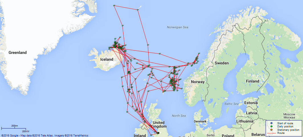
(Maps prepared using Journey Plotter, developed by Maikel. The Plots can only be approximate. They are made by joining-up positions on successive days, and sometimes positions are not given. There will therefore be occasions when the ship appears to have travelled overland) LOGS FOR APRIL 1915 4caf8393cadfd34197000fc0: (http://oldweather.s3.amazonaws.com/ADM53-33260/ADM53-33260-002_1.jpg) [Page with signature of TE Wardle, Commander in Command, no other information filled in] 4caf8393cadfd34197000fc1: (http://oldweather.s3.amazonaws.com/ADM53-33260/ADM53-33260-003_0.jpg) [Details of Barometer and Thermometers] Barometer Mercurial or Aneroid: Mercurial Name of Maker and number: Height of cistern above sea: 63 feet Error of Mercurial Barometer Standard Thermometers for Air Temperature Position in Ship: Whether in screen: Not supplied up to date of log Maker and No: Thermometer for Sea Temperature Maker and No: Not supplied up to date of log 4caf8393cadfd34197000fc2: (http://oldweather.s3.amazonaws.com/ADM53-33260/ADM53-33260-003_1.jpg) 16 April 1915 At Liverpool Lat 53.43, Long -3.01 [estimated] 8.0am: Commissioned ship. 11.0am: Shore gang coaling ship. 1.15pm: Hands fell in and told off as requisite. 5.0pm: Leave to Starboard Watch till 7.0am. 4caf8393cadfd34197000fc3: (http://oldweather.s3.amazonaws.com/ADM53-33260/ADM53-33260-004_0.jpg) 17 April 1915 At Liverpool Lat 53.43, Long -3.01 7.10am: Hands fall in and told of as requisite. 8.0am: Hands embarking 6" shell. 1.15pm: Hands employed embarking 6” shell and ammunition. pm: Shore gang coaling ship. 7.0pm: Completed ammunitioning. Leave to Port Watch till 7.0am. 4caf8393cadfd34197000fc4: (http://oldweather.s3.amazonaws.com/ADM53-33260/ADM53-33260-004_1.jpg) 18 April 1915 At Liverpool Lat 53.43, Long -3.01 4.0am: Shore gang coaling ship. 8.30am: Landed Roman Catholics for Service. 9.40am: Divisions and Prayers. 9.45am: Roman Catholics returned. Noon: Leave to Starboard Watch till 6.0am. 9.0pm: C/O [Commanding Officer] Rounds. Finished coaling ship. [Fuel Remaining: Coal 3856 tons]. 4caf8393cadfd34197000fc5: (http://oldweather.s3.amazonaws.com/ADM53-33260/ADM53-33260-005_0.jpg) 19 April 1915 At Liverpool Lat 53.43, Long -3.01 6.10am: Hands employed cleaning ship. 1.15pm: Hands employed as requisite for stability tests. 2.0pm: Taking in Gunnery and Medical Stores. 3.45pm: Leave to Port Watch till 7.0am. 4.15pm: Starboard Watch drawing stores. 7.0pm: 6 Stoker ratings joined ship from Devonport. 4caf8393cadfd34197000fc6: (http://oldweather.s3.amazonaws.com/ADM53-33260/ADM53-33260-005_1.jpg) 20 April 1915 At Liverpool Lat 53.43, Long -3.01 1.0am: 63 Fireman joined ship from Southampton. 8.45am: Hands employed cleaning paintwork and as requisite. 1.0pm: Shifted ship to new berth across dock. 1.15pm: Hands employed drawing Paymasters and Boatswains stores. 5.0pm: Leave to Starboard Watch till 7.0am. 4caf8393cadfd34197000fc7: (http://oldweather.s3.amazonaws.com/ADM53-33260/ADM53-33260-006_0.jpg) 21 April 1915 At Liverpool Lat 53.43, Long -3.01 am and pm: Hands employed cleaning paintwork. 6.45pm: 20 Boys joined ship from Devonport. 7.0pm: 4 Royal Marines joined ship from Ports[mouth]. 4caf8393cadfd34197000fc8: (http://oldweather.s3.amazonaws.com/ADM53-33260/ADM53-33260-006_1.jpg) 22 April 1915 At Liverpool Lat 53.43, Long -3.01 1.15pm: Hands employed drawing stores and as requisite. 4.30pm: Evening Quarters. Leave to Starboard watch till 7.0am. 4caf8393cadfd34197000fc9: (http://oldweather.s3.amazonaws.com/ADM53-33260/ADM53-33260-007_0.jpg) 23 April 1915 At Liverpool Lat 53.43, Long -3.01 6.10am: Hands employed shifting ship. 2.30pm: 1 Fireman discharged to Hospital. 6.0pm: Leave to Port watch till 7.0am. [Misty through middle of the day] 4caf8393cadfd34197000fca: (http://oldweather.s3.amazonaws.com/ADM53-33260/ADM53-33260-007_1.jpg) 24 April 1915 At Liverpool Lat 53.43, Long -3.01 6.10am: Shifted ship across dock. Hands employed cleaning ship. 1.30pm: Leave to Starboard Watch till 7.0am. pm: Hands make and mend clothes. 3.30pm: Shifted ship across dock. 4.30pm: Shifted ship across dock. [Rain for most of the day] 4caf8393cadfd34197000fcb: (http://oldweather.s3.amazonaws.com/ADM53-33260/ADM53-33260-008_0.jpg) 25 April 1915 At Liverpool Lat 53.43, Long -3.01 8.45am: Divisions and inspection by CO. 9.30am: Church. Noon: Leave to Port Watch till 7.0am. [Fuel Remaining: Coal 3869 tons (104 received)] 4caf8393cadfd34197000fcc: (http://oldweather.s3.amazonaws.com/ADM53-33260/ADM53-33260-008_1.jpg) 26 April 1915 At Liverpool Lat 53.43, Long -3.01 1.15pm: Hands employed cleaning paintwork and drawing stores. 3.0pm: Shifted ship to allow Saxonia [possibly this ship] to come inside. 5.0pm: Leave to Starboard Watch till 7.0am. 6.0pm: Pritchard POI joined from Hospital. 4caf8393cadfd34197000fcd: (http://oldweather.s3.amazonaws.com/ADM53-33260/ADM53-33260-009_0.jpg) 27 April 1915 At Liverpool Lat 53.43, Long -3.01 8.45am: Hands employed:- Starboard Watch painting ship’s side, Remainder as requisite. 1.0pm: Shifted ship from Huskisson Dock to alongside Mauretania in Sandon Half Tide Dock. 3.0pm: Secured. 6.0pm: Leave to Port Watch till 7.0am. 4caf8393cadfd34197000fce: (http://oldweather.s3.amazonaws.com/ADM53-33260/ADM53-33260-009_1.jpg) 28 April 1915 At Liverpool Lat 53.43, Long -3.00 [estimated] 9.30am: HMS “Alsatian” sailed 6.0pm: Leave to Port Watch till 7.0am, Boys till 7.0pm. 8.30pm: POI Armourer joined ship from Portsmouth. 4caf8393cadfd34197000fcf: (http://oldweather.s3.amazonaws.com/ADM53-33260/ADM53-33260-010_0.jpg) 29 April 1915 At Liverpool Lat 53.43, Long -3.00 8.0am: Hands clean into painting rig. am and pm: Hands employed cleaning paintwork and as requisite. Noon: Hoisted new lifeboat inboard. 1.30pm: Leave to Boys till 7.0pm. 4.30pm: Leave to Starboard Watch till 7.0am. 6.55pm: 1 RMLI [Royal Marines Light Infantry] and 1 Boy 1st Class discharged to Hospital. 8.30pm: 1 Marine joined ship from Gosport. 4caf8393cadfd34197000fd0: (http://oldweather.s3.amazonaws.com/ADM53-33260/ADM53-33260-010_1.jpg) 30 April 1915 At Liverpool Lat 53.43, Long -3.00 10.0am: Hands employed getting in stores, cleaning paintwork and as requisite. Ship taking in ballast. 2.0pm: Leave to firemen till 7pm. 2.25pm: Discharged Chief Armourer and 1 Sick Berth Attendant. 6.0pm: Hands getting in stores. 7.0pm: Leave to Port Watch till 7.0am. LOGS FOR MAY 1915 4caf8393cadfd34197000fd1: (http://oldweather.s3.amazonaws.com/ADM53-33260/ADM53-33260-011_0.jpg) [Blank page] 4caf8393cadfd34197000fd2: (http://oldweather.s3.amazonaws.com/ADM53-33260/ADM53-33260-011_1.jpg) [Blank page] 4caf8393cadfd34197000fd3: (http://oldweather.s3.amazonaws.com/ADM53-33260/ADM53-33260_0.jpg) [Left hand side of cover of Copy of Log for April 1915] 4caf8393cadfd34197000fd4: (http://oldweather.s3.amazonaws.com/ADM53-33260/ADM53-33260_1.jpg) [Right hand side of cover signed by AE Hernandez Lieutenant RNR, Navigating Officer] 4caf8393cadfd34197000fd5: (http://oldweather.s3.amazonaws.com/ADM53-33261/ADM53-33261-002_0.jpg) [Blank page] 4caf8393cadfd34197000fd6: (http://oldweather.s3.amazonaws.com/ADM53-33261/ADM53-33261-002_1.jpg) [Page signed by Commander in Command, as before and dated 7 June 1915, no other information] 4caf8394cadfd34197000fd7: (http://oldweather.s3.amazonaws.com/ADM53-33261/ADM53-33261-003_0.jpg) [Details of Barometer and Thermometers] Barometer Mercurial or Aneroid: Aneroid Name of Maker and number: F Smith and Son, Southampton Height of cistern above sea: 68 feet 3 inches Error of Mercurial Barometer: unknown Thermometers for Air Temperature Position in Ship: Lower Bridge Whether in screen: No Maker and No: Sewill 121. Date: Throughout Thermometer for Sea Temperature Maker and No: Sewill 122. Date: Throughout [Note - J. Sewill is a Liverpool manufacturer of nautical and meteorological instruments which still exists today] 4caf8394cadfd34197000fd8: (http://oldweather.s3.amazonaws.com/ADM53-33261/ADM53-33261-003_1.jpg) 1 May 1915 At Liverpool Lat 53.43, Long -3.00 11.45am: HMS Teutonic sailed. 1.15pm: Hands mustered for monthly payment. 2.30pm: Leave to Starboard Watch till 7.0am. 3.45pm: 1 Domestic discharged to shore. [Rain from 8am onwards] 4caf8394cadfd34197000fd9: (http://oldweather.s3.amazonaws.com/ADM53-33261/ADM53-33261-004_0.jpg) 2 May 1915 At Liverpool Lat 53.4, Long -3.0 8.30am: Landed Roman Catholics. 9.45am: Divisions and Captains Rounds. 10.0am: Roman Catholics returned. 10.30am: Divine Service. 1 Marine Rating joined ship from Gosport. 11.30am: Leave to firemen of 4-8 Watch till 2.0pm. 1.0pm: Leave to Starboard Watch till 7.0am, Boys till 7.0pm. 8.30pm: Leave to firemen till 7.0am. [Air and wet bulb temperature recorded from noon onwards, noon temperature 50F] 4caf8394cadfd34197000fda: (http://oldweather.s3.amazonaws.com/ADM53-33261/ADM53-33261-004_1.jpg) 3 May 1915 At Liverpool Lat 53.43, Long -3.00 1.15pm: Proceeded out of dock assisted by two tugs. 2.50pm: Came to Starboard anchor in 11 fathoms. Veered to 75 fathoms cable. [Anchor Bearings: New Brighton Tower West 0.6 miles] 3.30pm: Swung out and secured cutters. 4.40pm: Hands securing boats. 4.45pm: Customs tug alongside. 6.0pm: General Quarters, providing ammunition for all guns. 7.15pm: Secured. [Bearings Verified] 10.7pm: Sounded over stern, 10 fathoms. [Temperature peaked at 55F at 4pm, wind increasing through evening] 4caf8394cadfd34197000fdb: (http://oldweather.s3.amazonaws.com/ADM53-33261/ADM53-33261-005_0.jpg) 4 May 1915 At Liverpool Lat 53.44, Long -3.03 [estimated] [Ship at anchor. Bearings: North Wall Light N88W, No 11 Occulting Buoy N10W, New Brighton Tower S44W] 9.15am: Divisions and Prayers. Exercised General Quarters and Collision Stations. 11.55am: 1 Boy and 1 Steward joined ship from RN Barracks Portsmouth. 1.40pm: Tug left ship with working party. 2.50pm: Working party returned with stores. 4.40pm: Weighed port anchor and proceeded to new berth. 5.10pm: Anchored in 10 fathoms, Port anchor, Veered to 75 fathoms cable. [Rock Light S89W, New Brighton Tower S48W] 9.0pm: Weighed and proceeded. Course and speed as requisite. 11.0pm: Dropped Pilot. 11.30pm: Bar Light abeam. Course N47W, Revs 84. [Misty with passing showers through middle of the day, winds force 5 to 4] 4caf8394cadfd34197000fdc: (http://oldweather.s3.amazonaws.com/ADM53-33261/ADM53-33261-005_1.jpg) 5 May 1915 From Liverpool, at Sea Lat 55.63, Long -7.08 2.30am: Observed Chicken Rock Light. 2.50am: Commenced zigzagging 1 point each side of course. 6.42am: Mew Island S87W. Distant 3 miles. 8.15am: Altered course to avoid trawlers. 2.37pm: Courses various. Challenged HMS “Montagu” [this must be a somewhat dyslexic reference to HMS Motagua, given the fact that HMS Montagu sank in 1906 off Lundy Island and Motagua was in the area at the time - see her log for this date] pm: Zigzagging every 5 minutes, 2 points. Manned Nos 2 and 3 6 inch Guns. 4.30pm: Evening Quarters and Night Defence. 5.10pm: Sighted Barra Head E by N. 5.27pm: Barra Head Light abeam 10 miles. Log 83.4, altered course N25W. 11.5pm: Altered course N9W, Log 71, Revs 68. [Course and Distance made good: Various 211 miles] [True Bearing and Distance: Barra Head 345 degrees. Distant 72.5 miles] [Misty on and off for most of the day] 4caf8394cadfd34197000fdd: (http://oldweather.s3.amazonaws.com/ADM53-33261/ADM53-33261-006_0.jpg) 6 May 1915 From Liverpool, at Sea Lat 60.47, Long -12.33 9.0am: Zigzagging 1 Point. 0.5pm: Stopped Engines. 0.10pm: Proceeded course N26E, Revs 74. 0.45pm: Altered course to intercept SS, Log 550.2. 2.24pm: Stopped to Lower seaboat. 3.0pm: Prize crew put on SS “Otterstad” of Arendal [Norway], Sub Lieutenant Price in charge. 3.40pm: Hoisted seaboat. Set Course N27E, 74 Revs. 3.45pm: Lat 60 8 N, Long 12 6 W. [Distance run through the Water: 342.7 miles] [Misty and damp for most of the day, maximum temperature 49F at 8am] 4caf8394cadfd34197000fde: (http://oldweather.s3.amazonaws.com/ADM53-33261/ADM53-33261-006_1.jpg) 7 May 1915 From Liverpool, at Sea Lat 64.48, Long -12.42 10.25am: Challenged HMS “Hildebrand”. 11.0am: Carried out gun trials, altered course S45E, Log 39.1. 11.27am: Completed gun trials. Course N40E, Log 44. 4.20pm: Evening Quarters and Night defence. [Soundings at 5pm, 6pm 7pm and 8pm] 8.45pm: Darkened ship. 10.15pm: Sounded 57 fathoms fs [fine sand], Log 95.4. [Distance run through the Water: 310.1 miles] [Winds force 2 to 6 during day, temperature dropping from a high of 42F at 4am, down to 30F at 8pm and midnight] 4caf8394cadfd34197000fdf: (http://oldweather.s3.amazonaws.com/ADM53-33261/ADM53-33261-007_0.jpg) 8 May 1915 From Liverpool, at Sea Lat 67.12, Long -16.13 2.0am: Sighted Rioshall [?] Light bearing S26W, altered course N30E, reduced to 65 revs, zigzag 3 points every 5 minutes. 6.42am: Sighted icebergs, altered course N30E. Log 72. 7.0am: Zigzag 3 points every 10 minutes. 0.30pm: Altered course S30W. Log 81.5. 3.15pm: Altered course N30E, Log 17.5. 6.0pm: Altered course S36W. Log 54. 7.26pm: Sighted land bearing S15W. 8.45pm: Altered course N40E. Log 29.0. 11.25pm: Altered course S30W. Log 24.0. [Course and Distance made good: Various 335 miles] [True Bearing and Distance: Resnaes [presumably Revsnaes] Light House S (True), 34 miles. [Squally with snow at 4pm, when air temperature 32F; sea temperature recorded from 8pm onwards - 32F] 4caf8394cadfd34197000fe0: (http://oldweather.s3.amazonaws.com/ADM53-33261/ADM53-33261-007_1.jpg) 9 May 1915 From Liverpool, at Sea Lat 67.17, Long -16.33 1.40am: Observed Revsnaes Light S25W (Compass), Log 55.6. 2.0am: Sounding lead and 50 fathoms wire lost while heaving in. 2.5am: Altered course N30E, Log 60.0. 3.45am: Observed icefield bearing NW, 3.4 miles. 4.20am: Altered course S30W, Log 95.5. 8.0am: Altered course N30E, Log 37.2. 9.45am: Divisions and Commanders inspection. 10.0am: Divine Service. 10.27am: Encountered icefield, courses various negative zigzag. 11.51am: Set course S60E, Log 83. [Changes of course in pm at 1.15, 2.35, 6.15 and 9.30] [Distance run through the Water: 310.8 miles] [Temperature 30F at 4am, sea temperature 29F, misty in middle of day, rain and snow in pm] 4caf8394cadfd34197000fe1: (http://oldweather.s3.amazonaws.com/ADM53-33261/ADM53-33261-008_0.jpg) 10 May 1915 From Liverpool, at Sea Lat 67.00, Long -15.70 [Patrolling to and fro in am] 3.30pm: Eased to 84 Revs, zigzag 2 points every 15 minutes. 3.55pm: Sighted HMS “Alsatian” SSE. 4.23pm: Altered course N30W. Steamed in company with HMS “Alsatian” 75 Revs. 11.15pm: Observed several icebergs. [Course and Distance made good: Various 292.0 miles] [True Bearing and Distance: Rendezvous S66E, 76 miles] [Winds force 4 to 5 all day, peak temperature 32F at 4pm, sea temperatures ranging from 31 to 34F, barometric pressure relatively high] 4caf8394cadfd34197000fe2: (http://oldweather.s3.amazonaws.com/ADM53-33261/ADM53-33261-008_1.jpg) 11 May 1915 From Liverpool, at Sea Lat 67.75, Long -14.72 [Numerous changes of course and speed from 0.4am to 3.20am] 5.0am: Courses as requising [sic] for coasting along ice field. 11.0am: Courses as requisite for rounding ice field. 2.0pm: Sighted smoke of steamer and increased to 80 Revs, Log 2132.3. 2.40pm: Eased to 40 Revs. Stopped engines and handed log. 3.0pm: Boarded sealer “Polaris” of Bergen. 3.40pm: Set course S35E, 68 Revs. 8.0pm: Manned No 2 and 3 6 inch guns and 6 pounder. 8.20pm: Altered course S75W. Commenced to zigzag 1 point each side every 10 minutes. 11.30pm: Darkened ship. [Course and Distance made good: Various 328 miles] [Temperatures during day varying between 27 and 31F, sea temperatures from 29 to 31F] 4caf8394cadfd34197000fe3: (http://oldweather.s3.amazonaws.com/ADM53-33261/ADM53-33261-009_0.jpg) 12 May 1915 From Liverpool, at Sea Lat 66.33, Long -18.00 2.15am: Sighted land bearing S65W, Log 2287.2. 3.25am: Revsnez [Revsnaes] Light bearing S60W, 10 Miles, Log 2303.6. 5.0am to 8.0am: Courses as ordered for ascertaining extent of ice floe. 2.0pm: Guns crews fell out (Captain’s orders). 6.30pm: Randanafs [?] bearing N. Distant 3.5 miles, altered course S66E, Log 2494.0. 6.37pm: Altered course E, to intercept steamer. 6.50pm: Signalled Danish SS “Nexos” from Ardrossan [Scotland] to Iceland. 8.0pm: Zigzagging 2 points every 15 minutes. [Distance run through the Water: 307.4 miles] 4caf8394cadfd34197000fe4: (http://oldweather.s3.amazonaws.com/ADM53-33261/ADM53-33261-009_1.jpg) 13 May 1915 From Liverpool, at Sea Lat 65.08, Long -10.27 0.10am: Observed Langanaes [Langanes] Light S7E, Log 2567.3. 1.35am: Langanaes Light abeam S36W (True), distant 3.7 miles. Commenced zigzag 1 point each side. Log 2580.2. 10.30am: All electrically controlled WT [watertight] doors closed and opened. 2.0pm: Increased to 80 Revs, negative zigzag. Log 2756.3. [Course and Distance made good: Various 308 miles] [True Bearing and Distance: 10 miles N of Lunda Light S85E, 509 miles] [Number on sick list: 8] [Snow all morning, gloomy in afternoon, then more snow, wind force 6 in pm, sea state rough in evening] 4caf8394cadfd34197000fe5: (http://oldweather.s3.amazonaws.com/ADM53-33261/ADM53-33261-010_0.jpg) 14 May 1915 From Liverpool, at Sea Lat 63.88, Long 2.70 1.40pm: Challenged “stranger”. Reply HMS “Donegal”. 6.45pm: Altered course N32E. Challenged HMS “India”. 7.5pm: Altered course S80E, Log 3197, to intercept SS. 7.37pm: Altered course N61E, SS having prize crew on board from HMS India. 8.0pm: Zigzag 2 points each side of course. 9.5pm: Altered course S50E to intercept SS, log 3225.3. [Course and Distance made good: S80E, 364 miles] [True Bearing and Distance: Position N end of patrol N68E, 156 miles] [Number on sick list: 9] [Rain and showers for much of the day, temperature 41F at 4pm, sea temperature 45F] 4caf8394cadfd34197000fe6: (http://oldweather.s3.amazonaws.com/ADM53-33261/ADM53-33261-010_1.jpg) 15 May 1915 From Liverpool, at Sea Lat 64.58, Long 8.00 2.45pm: Halten island Light House S37E. 3.0pm: Halten Island Light House South (True), 5.2 miles, altered course N35W. Log 3456.9. 6.0pm: Close electrically controlled WT [watertight] doors. [Distance run through the Water: 331.6 miles] [True Bearing and Distance: 5 miles N of Lunda Light S64E, 45 miles (True)] [Number on sick list: 10] 4caf8394cadfd34197000fe7: (http://oldweather.s3.amazonaws.com/ADM53-33261/ADM53-33261-011_0.jpg) 16 May 1915 From Liverpool, at Sea Lat 64.90, Long 8.93 11.15pm: Latitude Polaris 65 16 N, altered course S10W, log 3856.5. [Course and Distance made good: Various 305 miles] [Number on sick list: 10] [Nothing much happening today as Alcantara patrols to and fro but squally winds up to force 8 in morning (with sea state rough to very rough), dropping to force 4 later on, barometric pressure relatively low, down to 29.06 over 52 at 4pm, then starting to rise] 4caf8394cadfd34197000fe8: (http://oldweather.s3.amazonaws.com/ADM53-33261/ADM53-33261-011_1.jpg) 17 May 1915 At Sea Lat 65.20, Long 8.77 6.55am: Altered course N67W to intercept SS. 7.30am: Stopped. Lieutenant Commander Tarrant boarded Norwegian SS “Leander”. 8.9am: Hoisted boat and proceeded course S75W, 67 Revs, Log 3961. 11.8am: Altered course to intercept SS, N15E, Log 3995. 2.0pm: Closed Electrically controlled WT doors. 5.20pm - 7.20pm: Courses as requisite to Navigating Lieutenant’s orders. 7.20pm: Halden [Halten] Light House bearing S (True) 13 miles, altered course N10E. 7.30pm: Zigzag 2 points each way every 10 minutes. 11.13pm: Altered course S59W to avoid SS bound NNE, Log 4151 (Norwegian SS “Havos” [possibly Havsø]). 11.18pm: Resumed Course, Log 4152. [Course and Distance made good: Various 286 miles] [Number on sick list: 8] [Winds force 4 to 6 during day, sea state very rough in early morning, barometric pressure rising] 4caf8394cadfd34197000fe9: (http://oldweather.s3.amazonaws.com/ADM53-33261/ADM53-33261-012_0.jpg) 18 May 1915 At Sea Lat 64.45, Long 8.25 [Nothing of note happened today, entries from log shown below as example, omitting changes in course and log readings every few hours and “WTSBC”, indicating Wireless Telegraph and Signal Books Correct, every 4 hours:] 9.30am: Divisions and Prayers. 9.45am: Exercised Fire Stations. Divisional Drill. 4.30pm: Evening Quarters and night defence. 6.0pm: Closed Electrically controlled WT [watertight] Doors. [Course and Distance made good: Various 309 miles] [Number on sick list: 8] 4caf8394cadfd34197000fea: (http://oldweather.s3.amazonaws.com/ADM53-33261/ADM53-33261-012_1.jpg) 19 May 1915 At Sea Lat 65.10, Long 9.10 0.30am: Sighted smoke bearing S by E (Magnetic). 6.20am: Altered course N48W to intercept SS. 6.50am: Stopped and boarded Norwegian SS “Steinstad” Kirkness [possibly Kirkenes] to Middlesbrough, circling round SS. 7.32am: Allowed SS to proceed. Hoisted in boat. 7.33am: Set Course N57E, 67 Revs, Log 4562. 9.55am: Altered course N78E to intercept trawler, Log 4592. 10.40am: Stopped and boarded trawler. 11.5am: Hoisted in boat. Set course N57E. 0.30pm: Sighed land bearing S45E. 2.43pm: Observed Kia [Kya] bearing S29E (compass), Log 4643. 3.25pm: Zigzag every 5 minutes. 5.20pm: Kia Beacon bearing W (True) 2 miles, altered course S78W, Log 4678. 7.18pm: Halten Light House bearing South (True) 9 miles, log 4704. 8.10pm: Darkened ship. [Distance run through the Water: 291.9 miles] [True Bearing and Distance: Kia Island S35E, 53 miles] [Number on sick list: 7] 4caf8394cadfd34197000feb: (http://oldweather.s3.amazonaws.com/ADM53-33261/ADM53-33261-013_0.jpg) 20 May 1915 At Sea Lat 65.75, Long 9.70 2.0am: Sighted smoke bearing NE. 3.10am: Altered course to intercept SS, Log 4807.6. 3.25am: Stopped. Boarded SS “Malmland”. 4.0am: Prize crew left ship (Lat 64 30 N, [Long] 8 12 E). 4.15am: Boat returned and hoisted in. SS “Malmland” proceeded with Prize Crew, Sub Lieutenant Williamson in charge. Set Course N46E, 67 Revs, Log 4808.7. Zigzag 2 Points every 10 minutes. 7.39pm: Altered course S47W, log 5009. 8.25pm: Log carried away. 8.50pm: New log streamed. 9.0pm: Darkened ship. [Course and Distance made good: Various 302 miles] [Number on sick list: 9] 4caf8394cadfd34197000fec: (http://oldweather.s3.amazonaws.com/ADM53-33261/ADM53-33261-013_1.jpg) 21 May 1915 At Sea Lat 64.13, Long 7.40 8.5am: Altered course to intercept SS. 8.19am: Course and speed as requisite for approaching SS, Log 5158.0. 9.24am: Stopped. Boarded SS “Atland” of Gothenburg. 9.57am: Boat returned and hoisted inboard. Course as requisite. 3.30pm: Zigzag 2 Points every 10 minutes. 4.30pm: Evening Quarters and night Defence. 9.20pm: Halten Island Light House S (True), Distant 10 miles. [Distance run through the Water: 284.8 miles] [Number on sick list: 7] [Barometric pressure relatively high; noon temperature 45F, sea temperature 43F] 4caf8394cadfd34197000fed: (http://oldweather.s3.amazonaws.com/ADM53-33261/ADM53-33261-014_0.jpg) 22 May 1915 At Sea Lat 65.33, Long 9.10 1.45pm: Sighted land S44E. 4.26pm: South Kia Beacon S, Log 5555.6. 6.55pm: Halten Light House bearing S True, Log 88.5. [Distance run through the Water: 303.8 miles] [True Bearing and Distance: Kia S28E, 65 miles] [Number on sick list: 7] [Misty during middle of day, rain at midnight, maximum temperature 50F at 4pm, sea temperature 45F] 4caf8394cadfd34197000fee: (http://oldweather.s3.amazonaws.com/ADM53-33261/ADM53-33261-014_1.jpg) 23 May 1915 At Sea Lat 65.00, Long 8.80 8.40am: Altered course to intercept SS bound NE, log 5764. 8.52am: Stopped. Boarded Swedish SS Poleinkelin [?]. 8.54am: Circling round SS. 9.20am: Allowed SS to proceed. Hoisted boat and proceeded, course S47W, Log 5765. 9.30am: Divisions. 9.45am: Divine Service. 3.15pm: Altered course to intercept SS, 66 revs. 3.30pm: Stopped and boarded Norwegian SS “Snestad”. Circling round SS. 4.0pm: Hoisted boat and allowed SS to proceed. 4.10pm: Set Course S46W, 56 Revs. 9.0pm: Zigzag 2 points. [Course and Distance made good: Various 299 miles] [Number on sick list: 7] [Mist, then fog, throughout the day, winds force 3 or 4] 4caf8394cadfd34197000fef: (http://oldweather.s3.amazonaws.com/ADM53-33261/ADM53-33261-015_0.jpg) 24 May 1915 At Sea Lat 64.23, Long 7.53 5.25am: Negative zigzag. 6.5am: 66 Revs. Zigzag 2 Points. 11.45am: Challenged HMS “Ebro”. 2.15pm: Tested Engine Rooms WT [watertight] doors. [Course and Distance made good: Various 266.5 miles] [True Bearing and Distance: 10 miles N of Langanaes N 76 22 E, 590 miles] [Mist and rain all day, winds force 6 to 7 at midnight] 4caf8394cadfd34197000ff0: (http://oldweather.s3.amazonaws.com/ADM53-33261/ADM53-33261-015_1.jpg) 25 May 1915 At Sea Lat 65.72, Long -2.50 4.30pm: Evening Quarters and night defence. Read Warrant No 2. 6.0pm: Closed WT doors 1-6 Electrically. 6.5pm: Opened WT doors 1-6 Electrically. [Course and Distance made good: Various 196 miles] [True Bearing and Distance: 10 miles N of Langanaes Light House N80W, 304 miles] [Windy, force 4 to 7 all day, with mist during middle of the day] 4caf8394cadfd34197000ff1: (http://oldweather.s3.amazonaws.com/ADM53-33261/ADM53-33261-016_0.jpg) 26 May 1915 At Sea Lat 66.38, Long -14.18 7.0am: Observed High land S80W, log 6600.4. 11.30am: Langanaes [Langanes] Light House bearing S84W True, Distant 16 miles. 0.45pm: Langanaes Light House bearing S (True) 2.1 miles. 3.3pm: Altered course N52W, Log 6705.6. Observed Revsnaes Light House bearing S84W (True). 4.3pm: Revsnaes Light House S (True) 3 miles, altered course N62W. 6.5pm: Altered course N70W, Log 6748.4. Ice sighted NW. 7.45pm: Courses as requisite to Navigator’s orders, 66 Revs. 8.50pm: Siglenaes [Siglunes] Light House bearing S (True) 4.5 miles. 11.0pm: Set Course S13E, Log 6821.6. [Course and Distance made good: N83W, 305 miles] [True Bearing and Distance: Langanaes Light House N85W, 7.5 miles] [Mist or rain all morning, wind up to force 6 at midnight] 4caf8394cadfd34197000ff2: (http://oldweather.s3.amazonaws.com/ADM53-33261/ADM53-33261-016_1.jpg) 27 May 1915 At Sea Lat 66.44, Long -13.50 0.40am: Singlenaes [sic] Light House bearing S (True), Distant 3.5 miles, altered course S60E, 67 Revs, Log 6846. 2.45am: Flatey Light House bearing S (True), Distant 6 miles, altered course N86E, Log 6870. 6.0am: Spoke SS “Nexios” [possibly “Nexos” as seen earlier]. 6.26am: Altered course S54E, Log 6920.1. Hraumhofna Tange [Hraunhafnartangi] South (True), 3 miles. 10.10am: Challenged HMS “Alsatian”. 10.50am: Boat left ship. 11.15am: Hoisted boat and proceeded, keeping station E 1 mile of HMS Alsatian, speed various. 0.15pm: Altered course S12E, 67 Revs, zigzag 3 Points, 10 minutes. 3.20pm: Negative zigzag. 8.10pm: WT [watertight] door 25 closed. [Course and Distance made good: Various 319 miles] [Misty for much of the day, winds force 5 in pm] 4caf8394cadfd34197000ff3: (http://oldweather.s3.amazonaws.com/ADM53-33261/ADM53-33261-017_0.jpg) 28 May 1915 At Sea Lat 63.20, Long -12.00 5.12am: Altered course to intercept SS. 5.50am: Spoke ST [Steam Trawler] Seahorse No 533 of Hull [H533 - possibly this ship]. 5.52am: Set Course S33W, Log 7195. 7.28pm: Altered course to intercept ST Monarch GY29 [listed here]. 7.52pm: Resumed course N18W, Log 7365.5. [Distance run through the Water: 287.1 miles] [Course and Distance made good: Various 217 miles] [Squally winds in pm, up to force 7, sea state rough to very rough for most of day] 4caf8394cadfd34197000ff4: (http://oldweather.s3.amazonaws.com/ADM53-33261/ADM53-33261-017_1.jpg) 29 May 1915 At Sea Lat 63.30, Long -11.98 5.55am: Challenged HMS “Otway”. 2.12pm: Altered course S4W, Log 7590.0. Negative zigzag. 3.45pm: Sighted HMS “Otway” bearing S65E. Hull down. 6.0pm: Swung ship for adjusting compasses. 7.35pm: Challenged HMS “Oropesa”. 8.3pm: Stopped. Sent boat to HMS “Oropesa”. Circling round “Oropesa”. 8.35pm: Hoisted in boat with prize crew. Set Course N24E, Log 7667.0. 9.56pm: Altered course N65E to intercept ST steering South. 11.7pm: Stopped. Boarded Dutch ST No IJM [this indicates Ijmuiden but no registration number given]. 11.35pm: Hoisted in boat Set course N14E. [Course and Distance made good: Various 290.6 miles] 4caf8394cadfd34197000ff5: (http://oldweather.s3.amazonaws.com/ADM53-33261/ADM53-33261-018_0.jpg) 30 May 1915 At Sea Lat 63.30, Long -12.00 0.30am: Challenged HMS “Otway”. 6.0am: Challenged HMS “Oropesa”. 1.35pm: Challenged HMS “Oropesa”. 9.35pm: Altered course to intercept ST, Log 7959.6. 10.15pm: Altered course to intercept schooner. Courses and speed as requisite. 10.45pm: Set Course N33W, 67 Revs and allowed ship to proceed, l Log 7966.3. [Course and Distance made good: Various 284 miles] [Mist and rain on and off all day, winds force 6 to 7 in am, with sea state very rough] 4caf8394cadfd34197000ff6: (http://oldweather.s3.amazonaws.com/ADM53-33261/ADM53-33261-018_1.jpg) 31 May 1915 At Sea Lat 63.35, Long -12.00 2.13am: Courses various to intercept ST A164 of Aberdeen [Braconmoor - details here]. 3.7am: Boat left ship and boarded ST. 3.20am: Hoisted boat, allowed ST to proceed. 3.30am: Set course S68E, 67 Revs. 3.0pm: Sighted land bearing N22W. 8.15pm: Nos 26 and 27 WT Doors closed. 8.53pm: Negative zigzag. 9.30pm: Nos 17, 24 and 25 WT Doors closed. [Course and Distance made good: Various 284 miles] [Winds force 6 or 7 and sea state rough to very rough all pm] LOGS FOR JUNE 1915 4caf8394cadfd34197000ff7: (http://oldweather.s3.amazonaws.com/ADM53-33261/ADM53-33261-019_0.jpg) [Blank page] 4caf8394cadfd34197000ff8: (http://oldweather.s3.amazonaws.com/ADM53-33261/ADM53-33261-019_1.jpg) [Blank page] 4caf8394cadfd34197000ff9: (http://oldweather.s3.amazonaws.com/ADM53-33261/ADM53-33261_0.jpg) [Left hand side of cover of Copy of Log for May 1915] 4caf8394cadfd34197000ffa: (http://oldweather.s3.amazonaws.com/ADM53-33261/ADM53-33261_1.jpg) [Right hand side of cover, signed by Navigating Officer, as before] 4caf8391cadfd34197000e8f: (http://oldweather.s3.amazonaws.com/ADM53-33262/ADM53-33262-002_0.jpg) [Blank page] 4caf8391cadfd34197000e90: (http://oldweather.s3.amazonaws.com/ADM53-33262/ADM53-33262-002_1.jpg) [Page not filled in] 4caf8391cadfd34197000e91: (http://oldweather.s3.amazonaws.com/ADM53-33262/ADM53-33262-003_0.jpg) [Details of Barometer and Thermometers] Barometer Mercurial or Aneroid: Mercurial Name of Maker and number: Sharman D Neill, Belfast, No 1084 Height of cistern above sea: 67 feet Error of Mercurial Barometer: Standard Thermometers for Air Temperature Position in Ship: Fore Bridge Whether in screen: Yes Maker and No: X. Date: From 1 June to 30 June Thermometer for Sea Temperature Maker and No: Casartelli Bros. Date: From 1 June to 30 June New Instrument brought into use on 21st June 4caf8391cadfd34197000e92: (http://oldweather.s3.amazonaws.com/ADM53-33262/ADM53-33262-003_1.jpg) 1 June 1915 At Sea Lat 63.12, Long -12.22 1.30pm: Altered course to intercept ST. Handed Log. 1.35pm: Stopped and boarded ST “Hermoine” [sic, probably Hermione, H992]. 1.55pm: Hoisted in boat, allowed ST to proceed. Set Course N20E. 4.28pm: Stopped, boarded ST “Electric” [probably GY236 listed here]. 4.35pm: Boat hoisted in, allowed ST to proceed. Course various. 4.55pm: Stopped, boarded Danish smack “Bonetio”. 5.25pm: Boat Hoisted in. Set Course S24E, 67 Revs, zigzag 2 points. 5.30pm: Challenged HMS “Arlanza”. 8.56pm: Altered course to intercept FS [Fishing Smack]. 9.24pm: Stopped, boarded smack “TG543” [TG being the registration for Trelleborg, Sweden or in this case more likely Trangisvaag, Faero Islands]. 9.52pm: Boat hoisted in. Set course N27W, Log 8519.5. [Course and Distance made good: Various 294.6 miles] [Wind force 6 at 4am, force 5 at 8am with sea state very rough, then wind dropping, temperature highest at 4am - 45F] 4caf8391cadfd34197000e93: (http://oldweather.s3.amazonaws.com/ADM53-33262/ADM53-33262-004_0.jpg) 2 June 1915 At Sea Lat 63.12, Long -11.73 9.40am: Altered course S, Log 8670.0, To intercept ST. 11.0am: Stopped, boarded ST “GY700” [Ninus, listed here]. 11.35am: Hoisted boat, Set course N65W, 67 Revs. 5.0pm: Swung ship for Deviations. Course S19E, Log 8751.8 [Course and Distance made good: Various 265 miles] 4caf8391cadfd34197000e94: (http://oldweather.s3.amazonaws.com/ADM53-33262/ADM53-33262-004_1.jpg) 3 June 1915 At Sea Lat 63.27, Long -11.98 8.0am: Altered course To Intercept ST H506 [Cornelian]. 9.15am: Set Course N50W, Log 8959.0. 0.10pm: Challenged by HMS “Arlanza”. 0.33pm: Altered course N22W, log 8999.5, zigzag 2 Points every 15 minutes. [Course and Distance made good: Various 306 miles] [Winds force 4 to 6 all day, temperature 48F from noon to 8pm, sea temperature 46F] 4caf8391cadfd34197000e95: (http://oldweather.s3.amazonaws.com/ADM53-33262/ADM53-33262-005_0.jpg) 4 June 1915 At Sea Lat 63.30, Long -12.00 8.0am: Course as requisite for intercepting ST. 9.10am: Sounded in 100 fathoms black sand. 10.50pm: Altered course to intercept ST. 11.15pm: Stopped. Boarded ST Wilhelmina IJM35. 11.40pm: Boat hoisted. Set course N43W, 67 revs. [Course and Distance made good: Various 294 miles] [Rain at 4am, wind force 5 or 6 throughout am, misty and force 4 in pm] 4caf8391cadfd34197000e96: (http://oldweather.s3.amazonaws.com/ADM53-33262/ADM53-33262-005_1.jpg) 5 June 1915 At Sea Lat 62.30, Long -9.97 8.3am: Altered course Various To intercept HMS “Orama”. 8.15am: Stopped. Transferred mails. 8.25am: Set course S22E, 75 Revs. 11.7am: 79 revs, zigzag 1 Point every 10 minutes. 0.30pm: Challenged HMS “Virginian”. 1.25pm: Stopped. Received HMS “Virginian’s” mails. 2.0pm: Proceeded on course S18E, 72 Revs, zigzag 1 Point every 10 minutes. 4.30pm: Evening Quarters and night defence. 4.55pm: Altered course S25W, Log 9646.0. 8.0pm: Darkened ship. 9.30pm: No 17, 24, 25, 26 and 27 WT Doors closed. [Course and Distance made good: 297 miles] [Wind force 4 to 5 all day, temperature 48-49F all day] 4caf8391cadfd34197000e97: (http://oldweather.s3.amazonaws.com/ADM53-33262/ADM53-33262-006_0.jpg) 6 June 1915 At Sea Lat 57.30, Long -8.57 5.30am: Observed St Kilda bearing S10E. 9.30am: St Kilda bearing W (True) Distant 19.8 miles, altered course S14E, 78 Revs, Log 9886.0. 9.45am: Divisions and Captains Rounds. 10.10am: Divine Service. 0.30pm: Commenced sounding every half hour. 4.45pm: Observed Skerryvore Light House S75E (True). 7.43pm: Encountered thick fog, slow ahead, negative zigzag. 8.0pm: Dead slow. 8.50pm: Nos 17, 24, 25, 26 and 27 WT Doors closed. [Course and Distance made good: Various 339 miles] [True Bearing and Distance: 10 miles West of Barra Head S33E, 36 miles] [Mist then fog all pm] 4caf8391cadfd34197000e98: (http://oldweather.s3.amazonaws.com/ADM53-33262/ADM53-33262-006_1.jpg) 7 June 1915 To Liverpool, at Sea Lat 53.56, Long -3.25 [rough estimate] [Details of Soundings: Number of Fathoms and nature of bottom; shown every half hour throughout morning, on far right of page] 0.20am: Observed Otter Rock Light bearing N72E, Rathlin Light S3W. 1.26am: Mull of Cantyre Light bearing S41E. 2.10am: Abeam. 3.35am: Ailsa Craig N44E. Mull of Cantyre N44W, altered course S6W, Log 10,110.0] 8.20am: Sighted Chicken Rock bearing S60E (Compass). 8.55am: 50 Revs. Encountered thick fog. 9.45am: Working up to full speed. 0.10pm: Altered course S70E, log 10,239.2. 0.25pm: Negative zigzag. 1.0pm: Handed Log. 1.3pm: Bar Light Ship abeam. Embarked Pilot. Courses and speed as requisite for entering harbour. 2.30pm: Anchored in 12 fathoms, Starboard anchor 5 shackles. All Ammunition returned. [Anchor Bearings: Salisbury Tower N63E (Magnetic), New Brighton Tower N21W (Magnetic), Ships Head N32W] 7.47pm: Tug left ship with Liberty men. 8.45pm: Ship swung to ebb. [Bearings: Egremont Pier N63W (Compass), North Wall Light N12E (Compass), Clock Tower N83E (Compass)] 9.30pm: Tug left ship with liberty men. [Course and Distance made good: Various 314 miles] [Fuel Remaining: Coal 730 tons] [Fog and mist all morning, noon temperature 59F, sea temperature 56F] 4caf8391cadfd34197000e99: (http://oldweather.s3.amazonaws.com/ADM53-33262/ADM53-33262-007_0.jpg) 8 June 1915 At Liverpool Lat 53.40, Long -3.03 [estimated] [Anchor Bearings: Egremont Pier N63W, North Wall Light N12E, Clock Tower N82E] 4.0am: Ship swung to flood. 6.45am: Weighed and proceeded into Alfred Basin, Birkenhead, assisted by two tugs. Engines as requisite. 7.54am: Ship made fast. am: Hands employed painting ship’s side. pm: Hands employed painting ship and as requisite. 2.0pm: Commenced coaling ship with shore gang. 2.30pm: 1 Seaman, 2 Stoker ratings joined ship from HMS “Eagle”. 4.30pm: Leave to first part Starboard Watch till 7am. 6.0pm: Stopped coaling. [Temperature 60 to 61F all day] 4caf8391cadfd34197000e9a: (http://oldweather.s3.amazonaws.com/ADM53-33262/ADM53-33262-007_1.jpg) 9 June 1915 At Liverpool Lat 53.40, Long -3.03 2.0am: Coaling ship. 7.0am: Hands employed painting ship. pm: Coaling ship. 6.0pm: Stopped coaling ship 4caf8391cadfd34197000e9b: (http://oldweather.s3.amazonaws.com/ADM53-33262/ADM53-33262-008_0.jpg) 10 June 1915 At Liverpool Lat 53.40, Long -3.03 2.0am: Coaling ship. 8.35am: Hands painting ship. 3.30pm: Hands embarking Paymaster stores. 4.30pm: Leave to second part starboard watch till 7am. 9.0pm: Rounds. Stopped coaling. [Temperature 68F at noon and 4pm] 4caf8391cadfd34197000e9c: (http://oldweather.s3.amazonaws.com/ADM53-33262/ADM53-33262-008_1.jpg) 11 June 1915 At Liverpool Lat 53.40, Long -3.03 7.30am: Coaling ship by shore gang. 9.00am: Stopped coaling. 10.30am: Port watch returned from leave. 11.30am: Leave to starboard watch till noon Tuesday [on this Friday]. 1.30pm: Commenced coaling ship. 4.30pm: Leave to first Port till 7.0am. Evening Quarters. 10.0pm: Coaling ship. [Misty from noon until 8pm, temperature 70F at 4 and 8pm] 4caf8391cadfd34197000e9d: (http://oldweather.s3.amazonaws.com/ADM53-33262/ADM53-33262-009_0.jpg) 12 June 1915 At Liverpool Lat 53.40, Long -3.03 5.40am: Completed coaling. 6.10am and 9.0am: Hands employed cleaning ship. 1.10pm: Leave to second Port till 7.0am. Hands make and mend clothes. 1.15pm: Discharged 1 Fireman to shore. 3.30pm: Discharged 1 Steward to shore. [Fuel Remaining: Coal 3796 tons] [Misty for most of the day] 4caf8391cadfd34197000e9e: (http://oldweather.s3.amazonaws.com/ADM53-33262/ADM53-33262-009_1.jpg) 13 June 1915 At Liverpool Lat 53.40, Long -3.03 7.45am: Landed Roman Catholics. 10.0am: Divine Service. 1.0pm: Leave to first Port till 7.0am. [Misty until 4pm, temperature peaked at 78F at 4pm] 4caf8391cadfd34197000e9f: (http://oldweather.s3.amazonaws.com/ADM53-33262/ADM53-33262-010_0.jpg) 14 June 1915 At Liverpool Lat 53.40, Long -3.03 8.45am: Hands employed cleaning paintwork and drawing stores. 1.15pm: Hands employed cleaning paintwork and drawing Bos’uns [Boatswain’s] and Paymaster’s stores. 4.30pm: Leave to second Port till 7.0am. [Misty again for much of the day] 4caf8391cadfd34197000ea0: (http://oldweather.s3.amazonaws.com/ADM53-33262/ADM53-33262-010_1.jpg) 15 June 1915 At Liverpool Lat 53.40, Long -3.03 9.15am: Hands employed cleaning ship’s side and drawing stores. 10.15am: 1 AB joined ship from RNB Portsmouth via HMS “Eagle”. Noon: Starboard watch returned off leave. 1.0pm: Hands employed painting ship. 4.35pm: Leave to Port Watch till 7.0am. 4caf8391cadfd34197000ea1: (http://oldweather.s3.amazonaws.com/ADM53-33262/ADM53-33262-011_0.jpg) 16 June 1915 At Liverpool Lat 53.40, Long -3.03 1.15pm: Hands employed cleaning ship and drawing Navigators, Gunners, Bosuns and Carpenters stores. 5.0pm: Leave to Starboard Watch till 7.0am. [Misty all pm] 4caf8392cadfd34197000ea2: (http://oldweather.s3.amazonaws.com/ADM53-33262/ADM53-33262-011_1.jpg) 17 June 1915 At Liverpool Lat 53.40, Long -3.03 3pm: Leave to CPOs and POs till 8.0pm. [Misty again for much of the day, temperature 55 or 56F all day] 4caf8392cadfd34197000ea3: (http://oldweather.s3.amazonaws.com/ADM53-33262/ADM53-33262-012_0.jpg) 18 June 1915 At Liverpool [and at Sea] Lat 54.85, Long -5.50 1.10am Cast off from Quay and proceeded out of basin assisted by two tugs. 1.40am: Proceeded down river, courses and speed as requisite. 3.5am: Formby Light Vessel abeam, disembarked pilot. 3.28am: Bar Light Ship bearing S (T). Set course N50W. Working to full speed, streamed Log and commenced zigzag 2 Points. 7.20am: Chicken Rock Light North (T) 7 miles, Log 60.5. 10.0am: South Rock Light S56W (T) 1 mile, altered course N16E, Log 104.6. 11.5am: Mew Island Light House West (T) 5 miles, altered course N9W, Log 122. 0.10pm: Maidens Light House W (T) 5 miles, altered course N23W. 1.15pm: Stopped by Patrol Boat. 1.25pm: Proceeded, Course as requisite to Navigator’s orders. 2.20pm: Tor Point S (T), 2 miles, altered course N59W, Log 175. 2.30pm: Rue Point N (T) 1 mile, altered course N47W, Log 177. 2.45pm: Commenced zigzagging 2 Points. 4.10pm: Altered course N15W, Log 204.7, Innistrahull [Inishtrahull] Light House W (Compass), 15 miles. 6.35pm: Skerryvore N23E (T), Log 245.1. 7.46pm: Skerryvore E (T), Log 264.9. 8.23pm: Altered course N16W, Log 274, Barra Head N4W, 12 miles. 10.0pm: 67 Revs. Barra Head E (T), 15 miles, log 301. [Course and Distance made good: Various 138 miles] [True Bearing and Distance: Maidens Light House N61W, 9.5 miles] 4caf8392cadfd34197000ea4: (http://oldweather.s3.amazonaws.com/ADM53-33262/ADM53-33262-012_1.jpg) 19 June 1915 From Liverpool Lat 58.10, Long -10.77 4.0am: St Kilda E (T) 30 miles. 9.20am: Altered course S21W, Log 460.1. 1 Point Zigzag. 10.0am: Altered course N9E, Log 468.8, 2 Points zigzag. 5.0pm: 1 Point Zigzag. 7.10pm: Challenged by HMS “Cedric”. 11.55pm: Challenged by HMS “Oropesa”. Midnight: Negative Zigzag. [Course and Distance made good: Various 357 miles] 4caf8392cadfd34197000ea5: (http://oldweather.s3.amazonaws.com/ADM53-33262/ADM53-33262-013_0.jpg) 20 June 1915 At Sea Lat 60.14, Long -11.02 [rough estimate] 1.20am: Altered course S5E. Log 670. 2.0am: Altered course N5W, 30 degrees zigzag. 5.0am: Altered course S5E. 8.0am: Altered course N5W. 11.0am: Altered course S5E. Log 794.0. 2.30pm: Altered course N3E. Log 838.4. 4.25pm: 1 Cell prisoner released. 4.30pm: Evening Quarters and night defence. 5.0pm: Altered course S3E. 6.55pm: Challenged HMS Oropesa. 9.0pm: Course as requisite to intercept SS. 10.17pm: Stopped. Boarded Norwegian SS “Conrad Mohr” of Bergen. 10.55pm: SS proceeded with prize crew, in charge Sub Lieutenant Vivian. Set Course S81W, 75 Revs. 11.7pm: Altered course S75W, 67 Revs. Challenged Oropesa. Midnight: Altered course S3E. [Course and Distance made good: Various 313 miles] 4caf8392cadfd34197000ea6: (http://oldweather.s3.amazonaws.com/ADM53-33262/ADM53-33262-013_1.jpg) 21 June 1915 At Sea Lat 60.77, Long -12.03 6.35am: Challenged by HMS “Oropesa”. 9.30am: Divisions and Prayers. 9.45am: General Quarters. Divisional Drill. 10.0am: Hoisted and swung in all life boats. 1:45pm: Altered course N4W, Zigzag 30 degrees, Log 1122.5. 8.0pm: Darkened ship. 8.30pm: Nos 25, 26 and 27 WT Doors closed. [Course and Distance made good: Various 294 miles] 4caf8392cadfd34197000ea7: (http://oldweather.s3.amazonaws.com/ADM53-33262/ADM53-33262-014_0.jpg) 22 June 1915 At Sea Lat 60.70, Long -12.02 8.53am: Altered course S60W, Log 1366.5 to intercept SS. 9.25am: Stopped. Boarded Norwegian SS Star [possibly this ship]. 10.49am: Boat hoisted, proceeded N35E, 67 Revs, Log 1371.2, Zigzag 3 Points. 9.30pm: Nos 17, 24, 25, 26 and 27 WT doors closed. [Course and Distance made good: Various 283 miles] [Rain and mist for much of the day] 4caf8392cadfd34197000ea8: (http://oldweather.s3.amazonaws.com/ADM53-33262/ADM53-33262-014_1.jpg) 23 June 1915 At Sea Lat 60.78, Long -12.10 10.54am: Swung ship for deviation to Navigator’s orders. 11.22am: Set course S3E, log 1680.6. 10.2pm: Altered course N65E, log 1814.2. Challenged by HMS “Oratava” [Orotava]. [Course and Distance made good: Various 303 miles] [Wind force 4 for most of day, maximum temperature 51F at noon, sea temperature 52F] 4caf8392cadfd34197000ea9: (http://oldweather.s3.amazonaws.com/ADM53-33262/ADM53-33262-015_0.jpg) 24 June 1915 At Sea Lat 60.78, Long -12.10 6.30am: Altered course W, Log 1918. Challenged [HMS] Changuinola. 9.45am: Exercised Collision stations. Divisional Drill. 9.30pm: Nos 17, 24, 25, 26 and 27 WT doors closed. [Course and Distance made good: Various 296 miles] [Another day patrolling to and fro, winds force 4 or 5 all day] 4caf8392cadfd34197000eaa: (http://oldweather.s3.amazonaws.com/ADM53-33262/ADM53-33262-015_1.jpg) 25 June 1915 At Sea Lat 60.78, Long -12.10 0.40pm: Challenged HMS “Ebro”. 1.50pm: Challenged HMS “Hildebrand”. 2.15pm: Stopped, boat left ship for “Hildebrand”. 2.30pm: Boat returned with Sub Lieutenant Vivian and armed guard. 2.32pm: Set course N22W, 67 Revs. 8.30pm: Challenged HMS “Andes”. [Course and Distance made good: Various 299 miles] 4caf8392cadfd34197000eab: (http://oldweather.s3.amazonaws.com/ADM53-33262/ADM53-33262-016_0.jpg) 26 June 1915 At Sea Lat 60.78, Long -12.10 4.55pm: Courses as requisite for intercepting sailing ship. 5.25pm: Stopped. Boarded schooner (Danish) Urda. 5.50pm: Boat hoisted, set course S39E, 67 Revs. [Course and Distance made good: Various 295 miles] 4caf8392cadfd34197000eac: (http://oldweather.s3.amazonaws.com/ADM53-33262/ADM53-33262-016_1.jpg) 27 June 1915 At Sea Lat 60.78, Long -12.10 3.0am: Challenged HMS “Montagua” [Motagua]. 9.30am: Divisions. 10.0am: Divine Service. 6.45pm: Challenged HMS “Orcoma”. 7.15pm: Stopped, boat left ship for “Orcoma”. 7.35pm: Boat hoisted, set course N32E, 74 Revs, Log 2961. 11.15pm: Challenged HMS “Orotava”. [Course and Distance made good: Various 294 miles] [Winds force 3 to 4 all day, misty from late am onwards] 4caf8392cadfd34197000ead: (http://oldweather.s3.amazonaws.com/ADM53-33262/ADM53-33262-017_0.jpg) 28 June 1915 At Sea Lat 60.32, Long -11.80 1.20am: Challenged HMS “Otway”. 8.0am: Negative zigzag. 9.3am: Courses as requisite for rifle firing at cask. 1 six pounder misfired cartridge thrown overboard. 9.25am: Proceeded N32E, Log 3155.0. 9.30am: Divisions and Prayers, Court martial returns read. 2.20pm: Courses various for intercepting SS. 2.32pm: Stopped, boarded Danish SSs “Triton” and “Rjukan”. 3.20pm: Boats returned and hoisted. Set course N6W, 74 Revs, Log 3225.9. 8.18pm: Dir Fjeld S61W, 16.2 miles. 9.53pm: Gunolfsvikar Fjeld [Gunnólfsvikurfjall] N71W. 11.50pm: Langanaes [Langanes] Light bearing W (T) 4 miles, altered course N36W, Log 3348. [Course and Distance made good: Various 319.6 miles] [True Bearing and Distance: 10 miles W of Langanaes Light House N25W, 140 miles] 4caf8392cadfd34197000eae: (http://oldweather.s3.amazonaws.com/ADM53-33262/ADM53-33262-017_1.jpg) 29 June 1915 At Sea Lat 66.50, Long -15.25 3.5am: Observed ice ahead. 5.35am: Observed icefield ahead. 5.43am: Courses various to intercept S/V, log 3432. 6.14am: Stopped, boarded SV Olga Pauline. 7.0am: Boat hoisted. 7.10am: Set course S75E, 67 Revs, Lat 66 25 N, Long 17 25 W. 9.45am: Courses various to intercept schooner, Log 3469.2. 9.55am: Stopped, boarded Danish schooner Felix [listed here]. 10.20am: Boat hoisted, set course S44E, 67 Revs. 11.55am: Langanaes S26E (C). 1.57pm: Langanaes Light House W (T) 5 miles, altered course S60E, Log 3513. 5.45pm: Dir Fjeld S33W (T), Distant 33.2 miles. [Course and Distance made good: Various 295 miles] [True Bearing and Distance: Langanaes Light House S57E, 22 miles] [Fairly quiet weather, winds force 3 and below, temperature peaked at 44F at 4pm, sea temperature 42F] 4caf8392cadfd34197000eaf: (http://oldweather.s3.amazonaws.com/ADM53-33262/ADM53-33262-018_0.jpg) 30 June 1915 At Sea Lat 63.68, Long -10.00 3.23am: Altered course S23W, Zigzag 2 Points every 10 minutes. 4.10pm: Altered course various to intercept ST. 4.50pm: Stopped, boarded Danish ST “Star of Hope”. 5.10pm: Boat hoisted, set course N62W, 67 Revs. 5.20pm: Altered course N83W to intercept SS. 5.45pm: Stopped. Boarded SS “Bredsund” (Norwegian). 6.20pm: Boat hoisted, set course S62E, 67 Revs, Log 3867.8. [Course and Distance made good: Various 314.5 miles] 4caf8392cadfd34197000eb0: (http://oldweather.s3.amazonaws.com/ADM53-33262/ADM53-33262-018_1.jpg) [Log page not filled in, with “END” at top] 4caf8392cadfd34197000eb1: (http://oldweather.s3.amazonaws.com/ADM53-33262/ADM53-33262-019_0.jpg) [Blank page] 4caf8392cadfd34197000eb2: (http://oldweather.s3.amazonaws.com/ADM53-33262/ADM53-33262-019_1.jpg) [Blank page] LOGS FOR JULY 1915 4caf8392cadfd34197000eb3: (http://oldweather.s3.amazonaws.com/ADM53-33262/ADM53-33262_0.jpg) [Left hand side of cover of Copy of Log indicating June, presumably in error] 4caf8392cadfd34197000eb4: (http://oldweather.s3.amazonaws.com/ADM53-33262/ADM53-33262_1.jpg) [Right hand side of cover, signed by Navigating Officer, as before] 4caf8392cadfd34197000eb5: (http://oldweather.s3.amazonaws.com/ADM53-33263/ADM53-33263-002_0.jpg) [Blank page] 4caf8392cadfd34197000eb6: (http://oldweather.s3.amazonaws.com/ADM53-33263/ADM53-33263-002_1.jpg) [Page not filled in] 4caf8392cadfd34197000eb7: (http://oldweather.s3.amazonaws.com/ADM53-33263/ADM53-33263-003_0.jpg) [Information about Barometer and Thermometers] Barometer Mercurial or Aneroid: Mercurial Name of Maker and number: Height of cistern above sea: 67 feet Error of Mercurial Barometer: Standard Thermometers for Air Temperature Position in Ship: Fore Bridge Whether in screen: Yes Maker and No: X. Date: From 1st July to 31st July Thermometer for Sea Temperature Maker and No: Casartelli Bros. Date: From 1st July to 31st July 4caf8392cadfd34197000eb8: (http://oldweather.s3.amazonaws.com/ADM53-33263/ADM53-33263-003_1.jpg) 1 July 1915 At Sea Lat 64.22, Long -5.65 3.0am: Zigzag 2 Points every 10 minutes. 7.45am: Swung ship for Deviation, Log 4041. 8.3am: Resumed course S23W. 8.28am: Course as requisite to intercept ST. 9.5am: Stopped, boarded Norwegian ST “Eystein”. 9.35am: Boat hoisted, proceeded 67 Revs, set course S23W, Log 4056.7. 0.45pm: Hands mustered for monthly payment. 8.30pm: Challenged HMS “Alsatian”. 9.27pm: Keeping station with HMS Alsatian, Course and speed as requisite. 10.0pm: Altered course N23E, Log 4218.2, 74 Revs. Parted company with HMS “Alsatian”. [Course and Distance made good: Various 287.5 miles] 4caf8392cadfd34197000eb9: (http://oldweather.s3.amazonaws.com/ADM53-33263/ADM53-33263-004_0.jpg) 2 July 1915 At Sea Lat 66.82, Long -6.05 7.30am: No 2 Guns crew fell out 0.37pm: Hauled in Log for repairs, Log 4433.1. 0.48pm: Log streamed. 4.30pm: Evening Quarters and night defence. [Distance run through the Water: 336.1 miles] [Heading N and E all day, apparently no longer on patrol] 4caf8392cadfd34197000eba: (http://oldweather.s3.amazonaws.com/ADM53-33263/ADM53-33263-004_1.jpg) 3 July 1915 At Sea [and at Jan Mayen Island] Lat 70.75, Long -9.25 [very rough estimate as very little information in log about where ship is at noon] 1.0am: Observed Burenberg Peak[Beerenberg, the main volcano on Jan Mayen Island] Peak N19E (C), Log 4613.2. 7.50am: Stopped, came to Port anchor in 20 fathoms, Veered to 60 fathoms cable. 8.20am: Boat left ship for land. 9.10am: Boat hoisted, weighed, proceeded 60 Revs, Course as requisite to orders. [Courses as requisite to Navigating Lieutenants orders] 1.30pm: Stopped, came to Port anchor in 10 fathoms, Veered to 45 fathoms cable. 1.40pm: Cutter left ship with first landing party. Manned No1 Starboard 6 inch gun. [Ship at anchor in Mary Muss Bay. Anchor Bearings: Eastern Point N80E, Vogelberg S58E, Pola Rock S62W, Braille Tower N89W] 2.15pm: Boat left the ship with Captain and First Lieutenant. 4.10pm: First Sea boat returned and hoisted. 4.30pm: Second Sea boat returned and hoisted. 5.0pm: Weighed and proceeded. 5.15pm: Stopped, came to Port anchor in 10 fathoms, Veered to 30 fathoms cable. 5.40pm: Weighed and proceeded, 67 Revs, Course as requisite, Braille Tower abeam. [Courses as requisite to Navigating Lieutenants Orders] 9.15pm: Stopped, came to Port anchor in 21 fathoms, Veered to 30 fathoms of cable. Boat left for shore. [Anchor Bearings, Compass: Rock N78.5E, Egg Bluff N10.5W, Ships Head S] 11.55pm: Boat returned and hoisted. Weighed and proceeded, Course and speed as requisite. Midnight: Set course S75E, 74 Revs. [Distance run through the Water: 299.3 miles] [For more information on Jan Mayen Island see here] 4caf8392cadfd34197000ebb: (http://oldweather.s3.amazonaws.com/ADM53-33263/ADM53-33263-005_0.jpg) 4 July 1915 At Sea Lat 71.20, Long -16.48 1.30am: Altered course N68W, Log 4796.5, Youngs Foreland bearing S (T), 2 miles. 11.35am: Eased to 74 Revs. Sighted ice bearing N60W. [Noon to 4pm and 5.30pm to 8pm: Courses as requisite for cruising along ice field] 1.0pm: 6 Pounder Gun Crew fell out. 8.45pm: Eased to 60 revs. 8.50pm: Encountered ice. Full speed astern and as requisite. 9.25pm: Set course East, Log 5068.9, 42 Revs. Midnight: Altered course South [Log] 5090.5. [Course and Distance made good: Various 236 miles] [Temperature peaked at 45F at noon, sea temperature 37F, mist and rain at 4pm, foggy for rest of pm] 4caf8392cadfd34197000ebc: (http://oldweather.s3.amazonaws.com/ADM53-33263/ADM53-33263-005_1.jpg) 5 July 1915 At Sea Lat 69.07, Long -13.88 [Course and Distance made good: Various 230 miles] [Travelling S in am and S and W in pm, only changes in speed noted in log, fog (sometimes thick) all day] 4caf8392cadfd34197000ebd: (http://oldweather.s3.amazonaws.com/ADM53-33263/ADM53-33263-006_0.jpg) 6 July 1915 At Sea Lat 66.01, Long -13.03 [very rough estimate as no position in log] 6.50am: Course as requisite for intercepting SS, Log 5333.0. 7.20am: Stopped, boarded SS “Snyg”. 7.55am: Boat hoisted, set course S18E, 67 Revs, Log 5357. 8.0am: Langanaes 6 miles Distant, S66W. 10.55am: Course as requisite for intercepting schooner. 11.5am: Stopped. Boarded Danish Schooner “H Petesen” [probably HH Petersen]. 11.25am: Boat hoisted, set course S18E, 67 Revs. 1.54pm: Altered course S45W, Log 5401.7. Increased to full speed to intercept SS. 2.26pm: Stopped, hoisted out boat and boarded Norwegian SS “Varo” [shown here under subsequent name]. 2.52pm: Boat hoisted, set course S19E, 67 Revs. [Distance run through the Water: 298.9 miles] [Fog (sometimes thick) almost all day again] 4caf8392cadfd34197000ebe: (http://oldweather.s3.amazonaws.com/ADM53-33263/ADM53-33263-006_1.jpg) 7 July 1915 At Sea Lat 64.05, Long -13.43 [extremely rough estimate as no position in log] 1.30am: Dead slow. Thick fog. 2.55am: Courses as requisite for intercepting SS, 30 Revs. 3.20am: Stopped. Boarded Danish SS “Vesta”. 3.50am: Boat hoisted, proceeded at 30 Revs. 11.15am: Course as requisite for intercepting SS. 0.35pm: Stopped. Boarded ST “Rhodesia” [possibly this ship]. 0.55pm: Boat hoisted, set course N65E, 72 revs. 1.30pm: Altered course to intercept schooner. 1.55pm: Stopped. Boarded Danish Schooner AH Friso [probably AH Friis]. 2.15pm: Boat hoisted, set course N37E, 67 Revs. 5.30pm: Altered course S23W, Log 5624.0, Zigzag 2 Points every 10 minutes. [Course and Distance made good: Various 293 miles] [Foggy early in day, misty during afternoon, patrolling to and fro] 4caf8392cadfd34197000ebf: (http://oldweather.s3.amazonaws.com/ADM53-33263/ADM53-33263-007_0.jpg) 8 July 1915 At Sea Lat 64.05, Long -13.43 [extremely rough estimate as no position in log] 6.45am: Stopped. Boarded Danish Schooner “Lala Rock” [possibly Laila Rookh, listed here]. 7.0am: Boat hoisted, set course S5E, 67 Revs, [Log] 5780.3. 10.45am: Course as requisite to intercept schooner. 11.35am: Stopped. Boarded Danish schooner “Freden”. 11.52am: Boat hoisted, set course N58W, 67 Revs. [Course and Distance made good: Various 263 miles] [Patrolling to and fro in am, heading N and E in pm, fog and mist in am and again at midnight] 4caf8392cadfd34197000ec0: (http://oldweather.s3.amazonaws.com/ADM53-33263/ADM53-33263-007_1.jpg) 9 July 1915 At Sea Lat 66.49, Long -17.26 [extremely rough estimate as position not shown in log] 1.15am: Altered course N38W, Log 6012.1. Langanaes [Langanes] W (T) 6 miles. 4.0am: Revsnaes Light House S63W (T). 5.48am: Rödehuk abeam 7 miles, Log 6076.0 7.40am: Observed ice ahead, altered course S78N, Log 6101. 9.5am: Stopped, hoisted out boat and boarded Norwegian Schooner Patriot and ST EA5 [EA being the registration for Eysafjord, Iceland] (Danish). 10.0am: Swung ship for deviations. 2.45pm: Rodebuk [Rodehuk] Point abeam 8 miles, Log 59. 3.35pm: Revsnaes Tower South (T) 7 miles, Log 69.2. 4.30pm: Course as requisite for adjusting compass. 5.15pm: Set course S29E, Log 6184.8. 8.57pm: Eased to 32 Revs. Thick fog. [Course and Distance made good: Various 289.0 miles] [Thick fog still recorded at midnight] 4caf8392cadfd34197000ec1: (http://oldweather.s3.amazonaws.com/ADM53-33263/ADM53-33263-008_0.jpg) 10 July 1915 At Sea Lat 66.80, Long -12.97 [extremely rough estimate as still no position in log] [Course and Distance made good: Various 243 miles] [Patrolling to and fro, log only records changes in speed and course for the day. Very foggy early am, mist and fog for rest of the day] 4caf8392cadfd34197000ec2: (http://oldweather.s3.amazonaws.com/ADM53-33263/ADM53-33263-008_1.jpg) 11 July 1915 At Sea Lat 66.57, Long -14.57 [extremely rough estimate as still no position in log] [Course and Distance made good: Various 256 miles] [Another day patrolling to and fro at an undisclosed location off Iceland. Wind force 4 to 5 in am, force 6 all pm, rain, mist and drizzle all day, temperature around 40F throughout] 4caf8392cadfd34197000ec3: (http://oldweather.s3.amazonaws.com/ADM53-33263/ADM53-33263-009_0.jpg) 12 July 1915 At Sea Lat 66.57, Long -14.57 [extremely rough estimate as still no position in log] 11.55pm: Altered course N to intercept SS, Log 6847.2. 1.45pm: Stopped. Boarded Norwegian SS “Stralsund”. 2.10pm: Boat hoisted, set course N62W, 67 Revs. [Still patrolling to and fro in the mist and fog] 4caf8392cadfd34197000ec4: (http://oldweather.s3.amazonaws.com/ADM53-33263/ADM53-33263-009_1.jpg) 13 July 1915 At Sea Lat 66.70, Long -16.74 [extremely rough estimate as no position in log] [Course and Distance made good: Various 276 miles] [Still patrolling to and fro in the mist and fog. Log only records routine matters, changes of speed and course and closing of watertight doors] 4caf8392cadfd34197000ec5: (http://oldweather.s3.amazonaws.com/ADM53-33263/ADM53-33263-010_0.jpg) 14 July 1915 At Sea Lat 66.89, Long -16.17 [extremely rough estimate in absence of position in log] [Course and Distance made good: Various 250 miles] [More of the same] 4caf8392cadfd34197000ec6: (http://oldweather.s3.amazonaws.com/ADM53-33263/ADM53-33263-010_1.jpg) 15 July 1915 At Sea Lat 67.10, Long -15.56 [another extremely rough estimate] [Course and Distance made good: Various 289 miles] [Still patrolling, still in the mist and fog, log now up to 7782.0 at 10pm, but one feels the crew must be getting rather bored] 4caf8392cadfd34197000ec7: (http://oldweather.s3.amazonaws.com/ADM53-33263/ADM53-33263-011_0.jpg) 16 July 1915 At Sea Lat 66.71, Long -13.77 [very rough estimate] 10.55am: Course as requisite for intercepting SS. 11.45am: Stopped. Boarded SS “Kepler” (Swedish). 0.20pm: Boat hoisted, set course N32W, 74 Revs. 3.47pm: Langanaes [Langanes] S (T) 3.7 miles, log 8002.5 6.38pm: Revsnaes Light House abeam 7 miles. 8.50pm: Observed Grimsey Island S78W (T), Rodehuk S77E (T). 10.0pm: North end of Grimsey S (T) 4 miles. 10.21pm: Speeds as requisite for fog. [Course and Distance made good: Various 294 miles] [Mist finally lifted by midday but foggy again in late evening] 4caf8392cadfd34197000ec8: (http://oldweather.s3.amazonaws.com/ADM53-33263/ADM53-33263-011_1.jpg) 17 July 1915 At Sea Lat 66.53, Long -18.00 1.0am: Speeds as requisite for fog. 5.30am: Observed ice on Starboard bow. 6.0am: Observed ice floes ahead. 6.25am: Sounded in 90 fathoms BS [black sand]. 1.12pm: Grimsey Island abeam 16 miles. 6.50pm: Revsnaes Light House S (T) 11 miles, altered course N39E, Log 8303. [Course and Distance made good: Various 281.0 miles] [True Bearing and Distance: Grimsey Island S 16 miles] [Fog then mist all day (again), sea temperatures recorded every hour in am, consistently 35F, rising to 40F in pm] 4caf8392cadfd34197000ec9: (http://oldweather.s3.amazonaws.com/ADM53-33263/ADM53-33263-012_0.jpg) 18 July 1915 At Sea Lat 66.58, Long -16.3 [Sounding regularly during am] 6.15am: Observed Cape Langanaes [Langanes] S67W. 9.55am: Divine Service. 4.7pm: Course as requisite to intercept steamers. 4.30pm: Stopped. Boarded Norwegian SSs “Snorre and Brodd”. 5.4pm: Boat hoisted, Course as requisite. [Course and Distance made good: Various 299 miles] [Misty all day yet again] 4caf8392cadfd34197000eca: (http://oldweather.s3.amazonaws.com/ADM53-33263/ADM53-33263-012_1.jpg) 19 July 1915 At Sea Lat 67.12, Long -16.17 8.24am: Courses as requisite for intercepting SS. 8.35am: Stopped. Boarded Norwegian SS Aalesund. 8.55am: Boat hoisted, set course N39E, Log 8771.0. 2.45pm: Revsnaes Light House S (T) 8 miles, altered course N39E, Log 8829.9. 4.30pm: Evening Quarters and night defence. 9.10pm: Course as requisite to intercept schooner. 9.40pm: Stopped. Boarded Danish Schooner “Active” [probably Activ]. 10.0pm: Boat hoisted, set course N60W, 67 Revs. 11.0pm: Worked to full speed. Course as requisite to intercept SS. 11.17pm: Stopped. Boarded Norwegian SS Alf [possibly this ship]. 11.50pm: Boat hoisted, set course N34W, 67 Revs. [Course and Distance made good: Various 289 miles] [Misty all day yet again] 4caf8392cadfd34197000ecb: (http://oldweather.s3.amazonaws.com/ADM53-33263/ADM53-33263-013_0.jpg) 20 July 1915 At Sea Lat 66.65, Long -16.00 [Course and Distance made good: Various 275 miles] [Yet another day patrolling to and fro in the fog and mist. Peak temperature 41F at noon, sea temperature 40F] 4caf8392cadfd34197000ecc: (http://oldweather.s3.amazonaws.com/ADM53-33263/ADM53-33263-013_1.jpg) 21 July 1915 At Sea Lat 66.83, Long -15.15 [estimated as noon position not shown in log] 2.0pm: Langanaes [Langanes] Light House S (T) 11 miles. [Course and Distance made good: Various 240 miles] [Thick fog, then mist in morning, finally clearing by noon] 4caf8392cadfd34197000ecd: (http://oldweather.s3.amazonaws.com/ADM53-33263/ADM53-33263-014_0.jpg) 22 July 1915 At Sea Lat 66.78, Long -16.62 [rough estimate as noon position not shown in log] 1.0am: Revsnaes Light House South (T), 3.5 miles. [Course and Distance made good: Various 267 miles] [Another day when nothing of note happened on patrol. Fog at 8am, then misty for rest of the day, rain from 8pm] 4caf8392cadfd34197000ece: (http://oldweather.s3.amazonaws.com/ADM53-33263/ADM53-33263-014_1.jpg) 23 July 1915 At Sea Lat 63.75, Long -4.79 [rough estimate, partly based on position of HMS Alsatian - see her log for this date] 10.20am: Stopped. Boarded Norwegian SS Thorchafter [possibly Thore Hafte]. 10.45am: Boat hoisted, set course S54E, Log 9873.7. 1.45pm: Challenged HMS “Alsatian”. 1.50pm: Courses various for closing, Log 9912.5. 2.35pm: Stopped. Boarded Swedish SS William. 3.5pm: Boat hoisted. 3.50pm: Proceeded 69 Revs to close with HMS “Alsatian”. 4.15pm: Keeping station half mile from “Alsatian”. 4.35pm: Boat left for Alsatian. Evening Quarters and night defence. 5.0pm: Boat returned. 5.15pm: Proceeded, Course as requisite. 5.30pm: Set course S46W, 72 Revs. 7.40pm: Observed high land S (T). 10.0pm: Myggenoes [Myggenaes, Faroe Islands] Light bearing S41W. 11.20pm: Myggenoes Light abeam S58E (T) 5 miles. 11.25pm: Zigzag 1 Point. [Distance run through the Water: 300.9 miles] [Misty on and off during am, with winds force 3 to 5, barometric pressure relatively low, down to 29.20 over 53 at noon, then starting to rise] 4caf8392cadfd34197000ecf: (http://oldweather.s3.amazonaws.com/ADM53-33263/ADM53-33263-015_0.jpg) 24 July 1915 At Sea Lat 58.80, Long -8.08 [very rough estimate as no position shown in log] 10.50am: Swung out all lifeboats. 7.30pm: St Kilda S30E. [Distance run through the Water: 300.6 miles] 4caf8392cadfd34197000ed0: (http://oldweather.s3.amazonaws.com/ADM53-33263/ADM53-33263-015_1.jpg) 25 July 1915 At Sea Lat 55.95, Long -7.60 [estimated, based on noon position for HMS Patia for this date] 6.40am: Barra Head N63E (T), 83 Revs. 8.38am: Altered course to speak trawler, Log 10449.4. 10.15am: Skerryvore Light House E (T) 15.5 miles. 11.50am: Challenged HMS Patia. 2.36pm: Altered course To Navigating Lieutenant’s Orders. 4.20pm: Tor Point W (T) 2 miles. 5.45pm: Maiden Light W (T) 2 miles, altered course S12E, Log 10594.2. 9.23pm: Altered course S30E, Log 10650.7. Chicken Rock E (T) 10 miles. 10.13pm: Chicken Rock N (T), 9.5 miles. [Distance run through the Water: 315.1 miles] 4caf8392cadfd34197000ed1: (http://oldweather.s3.amazonaws.com/ADM53-33263/ADM53-33263-016_0.jpg) 26 July 1915 At Sea [and Liverpool] Lat 53.43, Long -3.01 [estimated] 0.45am: St Ormes Head S (T), 10 miles. 1.40am: Courses as requisite to Navigator’s Orders. 2.44am: Bar Light Ship abeam. 2.58am: 67 Revs. Handed log 10,724.5. 3.2am: Pilot aboard. Full speed. 4.30am: Came to anchor in 18 fathoms. [Bearings: New Brighton Tower N13W (magnetic), Royal Liver Tower N36E, Wallasey Landing Stage S80W] 6.0am: Hoisted in all boats. 7.0am: Tug alongside for Postman. 9.0am: 4 Days leave to Starboard Watch. 9.30am: Weighed. 10.25am: Proceeded into Dock. 11.7am: Ship made fast in Sandon Dock. pm: Hands employed painting ship. 1 AB and 1 WT discharged to RN Barracks Portsmouth. 4.45pm: Leave to First Part Port till 7am. [Course and Distance made good: Various 230 miles] [Fuel Remaining: Coal 824 tons] [Rain and thunder during pm, noon temperature 56F] 4caf8392cadfd34197000ed2: (http://oldweather.s3.amazonaws.com/ADM53-33263/ADM53-33263-016_1.jpg) 27 July 1915 At Liverpool Lat 53.43, Long -3.01 7.30am: Commenced Coaling ship. 11.30am: Discharged 1 Boy to Hospital. 4.30pm: Leave to Second Port till 7.0am. [Rain at noon, passing showers all pm, with thunder and lightning at midnight] 4caf8392cadfd34197000ed3: (http://oldweather.s3.amazonaws.com/ADM53-33263/ADM53-33263-017_0.jpg) 28 July 1915 At Liverpool Lat 53.43, Long -3.01 am and pm: Hands painting ship. 1.30pm: 1 AB RFR [Royal Fleet Reserve] joined ship from HMS “Eagle”. 4.30pm: Leave to First Port till 7.0am. 4caf8392cadfd34197000ed4: (http://oldweather.s3.amazonaws.com/ADM53-33263/ADM53-33263-017_1.jpg) 29 July 1915 At Liverpool Lat 53.43, Long -3.01 Noon: Leave to Boys till 7pm. 4.30: Leave to Second Port till 7.0am. 4caf8392cadfd34197000ed5: (http://oldweather.s3.amazonaws.com/ADM53-33263/ADM53-33263-018_0.jpg) 30 July 1915 At Liverpool Lat 53.43, Long -3.01 1.30am: 2nd Steward joined ship from Southampton. pm: Port Watch leave for 4 days. pm: Hands employed drawing stores. 4.0pm: Leave to First Part Starboard till 7.0am. 4caf8392cadfd34197000ed6: (http://oldweather.s3.amazonaws.com/ADM53-33263/ADM53-33263-018_1.jpg) 31 July 1915 At Liverpool Lat 53.43, Long -3.01 pm: Hands drawing stores. 7.30pm: Leave to Second Part Starboard till 7.0am. 4caf8392cadfd34197000ed7: (http://oldweather.s3.amazonaws.com/ADM53-33263/ADM53-33263-019_0.jpg) [Blank page] 4caf8392cadfd34197000ed8: (http://oldweather.s3.amazonaws.com/ADM53-33263/ADM53-33263-019_1.jpg) [Blank page] LOGS FOR AUGUST 1915 4caf8392cadfd34197000ed9: (http://oldweather.s3.amazonaws.com/ADM53-33263/ADM53-33263_0.jpg) [Left hand side of cover of Copy of Log indicating July 1915 (possibly in error)] 4caf8392cadfd34197000eda: (http://oldweather.s3.amazonaws.com/ADM53-33263/ADM53-33263_1.jpg) [Right hand side of cover, signed by Navigating Officer, as before] 4caf8392cadfd34197000edb: (http://oldweather.s3.amazonaws.com/ADM53-33264/ADM53-33264-002_0.jpg) [Blank page] 4caf8392cadfd34197000edc: (http://oldweather.s3.amazonaws.com/ADM53-33264/ADM53-33264-002_1.jpg) [Page not filled in, signed by Captain Wardle] 4caf8392cadfd34197000edd: (http://oldweather.s3.amazonaws.com/ADM53-33264/ADM53-33264-003_0.jpg) [Details Barometer and Thermometers, as before] 4caf8392cadfd34197000ede: (http://oldweather.s3.amazonaws.com/ADM53-33264/ADM53-33264-003_1.jpg) 1 August 1915 At Liverpool Lat 53.43, Long -3.01 9.0am: Landed RC's [Roman Catholics] for Church. 9.10am: Divisions. 9.30am: Divine Service. 10.0am: Discharged 1 AB to Hospital. 1.45pm: Leave to First Starboard Watch until 7am August 2nd. [Completion of coaling not indicated in log but now have 3895.0 tons of coal remaining] [Rain in morning, gloomy at noon, temperature up to 69F in pm] 4caf8392cadfd34197000edf: (http://oldweather.s3.amazonaws.com/ADM53-33264/ADM53-33264-004_0.jpg) 2 August 1915 At Liverpool Lat 53.43, Long -3.01 7.0pm: Leave first part of watch until 7am August 3rd. 10.0pm: 1 OS joined ship from Devonport. [Rain on and off from noon onwards] 4caf8392cadfd34197000ee0: (http://oldweather.s3.amazonaws.com/ADM53-33264/ADM53-33264-004_1.jpg) 3 August 1915 At Liverpool Lat 53.43, Long -3.01 10.0am: Hands employed as requisite drawing provisions. pm: Hands employed as in forenoon. 4.15pm: Evening Quarters. 4.30pm: Read Warrant No 6. 7.0pm: Leave for second part of watch until 7am August 5th. 4caf8392cadfd34197000ee1: (http://oldweather.s3.amazonaws.com/ADM53-33264/ADM53-33264-005_0.jpg) 4 August 1915 At Liverpool Lat 53.43, Long -3.01 Noon: Hands preparing ship for sea. Received one Sub Lieutenant RNVR for passage to “Alsatian”. 2.0pm: Singled moorings. 3.15pm: Slipped from dock side. 3.55pm: Entered river assisted by two tugs. 4.40pm: Swung ship for adjusting compasses, swung out all boats. 5.30pm: General Quarters. Provided ammunition. 5.55pm: Cast off Tugs. 6.45pm: Disembarked pilot. 6.52pm: Formby Light Ship abeam. 7.2pm: Log streamed. 7.10pm: Set course N54W, Bar Light Ship abeam. Zigzag 2 Points. 10.55pm: Altered course N29W. Chicken Light N (T), 12 miles. Midnight: Chicken Light E (T) 11 miles. Altered course N12E. 4caf8392cadfd34197000ee2: (http://oldweather.s3.amazonaws.com/ADM53-33264/ADM53-33264-005_1.jpg) 5 August 1915 From Liverpool, at Sea Lat 56.43, Long -7.68 2.30am: Altered course N21W, Mull of Galloway E( T) 9 miles, Log 113.5. 3.55am: Altered course N32W, Maidens Light W (T), 5 miles, Log 135.4. 5.0am: Challenged HMS “Tara”. 5.15am: Negative Zigzag. 6.0am: Courses as requisite in Rathlin N channel. 6.15am: Zigzag 2 Points, course as requisite rounding Bull Point. 7.50am: Altered course N3W, Inishtrahull (W) (T) 9 miles, Log 195.0. 11.27am: Skerryvore Light House E (T) 17 miles. 0.40pm: Challenged HMS “Teutonic”. 1.10pm: Altered course N57W, Log 278.1, to signal trawler. 1.25pm: Altered course N20W, Log 280.6. Barra Head E (T) 10 miles. 5.5pm: Course as requisite to intercept SS. 5.27pm: Passed Norwegian SS Ruth. Armed guard on board. 8.0pm: Darkened ship. [Course and Distance made good: Various 259.0 miles] [True Bearing and Distance: Skerryvore Light House S71E, 20.5 miles] 4caf8392cadfd34197000ee3: (http://oldweather.s3.amazonaws.com/ADM53-33264/ADM53-33264-006_0.jpg) 6 August 1915 From Liverpool, at Sea Lat 61.10, Long -11.20 9.30am: Swung in all boats. 9.30am: Divisions and Prayers. Articles of War read. 10.0am: General Quarters. 3.50pm: Altered course as requisite. Challenged HMS “Andes” and “Ebro”. 4.0pm: Challenged HMS “Alsatian”. 4.20pm: Stopped. Boat left ship for HMS “Alsatian” with 1 Officer RNVR. 4.30pm: Evening Quarters and night defence. 4.45pm: Boat returned. Proceeded. 5.0pm: Set course N24E, “A” zigzag. 9.0pm: Nos 25. 26 and 27 WT Doors closed. [Course and Distance made good: Various 326 miles] 4caf8392cadfd34197000ee4: (http://oldweather.s3.amazonaws.com/ADM53-33264/ADM53-33264-006_1.jpg) 7 August 1915 At Sea Lat 64.78, Long -12.20 6.35am: Altered course W to intercept SS, Log 823.4. 7.10am: Challenged HMS “Digby”, Negative zigzag. 10.40am: Eased to 50 revs. Fog. 1.0pm: Sounded in 120 fathoms, Rock. [Course and Distance made good: Various 305.0 miles] [Mist and fog for most of the day] 4caf8392cadfd34197000ee5: (http://oldweather.s3.amazonaws.com/ADM53-33264/ADM53-33264-007_0.jpg) 8 August 1915 At Sea Lat 66.67, Long -16.33 9.30am: Divisions and Inspection by Captain. 10.0am: Divine Service. 1.0pm: Courses as required to Navigating Lieutenant’s Orders. Sounded in 54 fathoms, shingle. 2.35pm: Altered course N30E, Log 1193.0, Revsnaes S (T) 2 miles. [Course and Distance made good: Various 266 miles] [Log for the day mostly recording changes in speed and course. Thick fog at 4am, then mist for rest of am, air and sea temperature at 8pm 42F] 4caf8392cadfd34197000ee6: (http://oldweather.s3.amazonaws.com/ADM53-33264/ADM53-33264-007_1.jpg) 9 August 1915 At Sea Lat 67.05, Long -16.08 10.5am: Stopped. Boarded Danish schooner “Willimas” [probably Wiliemoes listed here - Willemoes in some references], Lat 66 44 N, [Long] 16 5 W. 10.30am: Boat hoisted. 10.36am: Set course N28E, 70 Revs. 4.50pm: Swung ship for adjusting compasses, Log 1500. 5.38pm: Set course N30E, Log 1505.7. [Course and Distance made good: Various 302 miles] [Misty all am, fog, sometimes thick, until late evening] 4caf8392cadfd34197000ee7: (http://oldweather.s3.amazonaws.com/ADM53-33264/ADM53-33264-008_0.jpg) 10 August 1915 At Sea Lat 66.63, Long -16.00 1.12pm: Courses as requisite to Navigator’s orders. 2.48pm: Courses as requisite to intercept SS. 3.5pm: Stopped. Boarded Norwegian SS “Swyg”, [Lat] 66 33 N, [Long] 15 32 W. 3.44pm: Boat hoisted, set course S55E, 70 Revs, in company with SS “Swyg”. 4.45pm: Courses as required. SS Swyg proceeded. 6.10pm: Altered course to intercept SS. 6.15pm: Stopped. Boarded Swedish SS Mimer [Mimer (1) listed here], [Lat] 66 37 N, [Long] 15 47 W. 6.45pm: Boat hoisted, set course S45E, 70 Revs, Log 1750.5. 8.25pm: Stopped. Sent prize crew in charge of Lieutenant Johnson on board Swedish SS Mimer. 8.50pm: Boat hoisted, set course N60W, Log 1772.6. 10.40pm: Altered course N30E, Log 1795.5, Revsnaes Light S (T) 2 miles. Midnight: Zigzagging. [Course and Distance made good: Various 234.0 miles] [Fog then mist in am, clear in pm] 4caf8392cadfd34197000ee8: (http://oldweather.s3.amazonaws.com/ADM53-33264/ADM53-33264-008_1.jpg) 11 August 1915 At Sea Lat 67.17, Long -16.20 2.19am: Eased to 50 Revs. Negative Zigzag. 3.32am: Increased to 70 Revs, zigzag. 3.53am: Sighted land ahead. 5.20am: Courses as requisite to intercept SS. 6.15am: Stopped. Boarded Danish SS “Gullfoss” [Gullfoss (1) listed here], [Lat] 66 37 N, [Long] 16 48 W. 6.35am: Boat hoisted. 7.5am: Stopped. Boarded Hull ST Peridot H234. 7.35am: Boat hoisted, set course S65E, 86 Revs, Log 1885.7. 8.15am: Revsnaes Light House S5E (T) 3 miles. 11.20am: 70 Revs. Zigzagging 1 Point. 2.0pm: Altered course N30E, Log 1976, Zigzag 2 Points. 4.30pm: Altered course S30W, Log 2008. Evening Quarters and night defence. 8.5pm: Altered course N30E, Log 2053, Revsnaes Light House S (T) 5 miles. [Course and Distance made good: Various 257 miles] [Foggy at 4am, then clear, wind force 4 to 5 in pm] 4caf8392cadfd34197000ee9: (http://oldweather.s3.amazonaws.com/ADM53-33264/ADM53-33264-009_0.jpg) 12 August 1915 At Sea Lat 66.83, Long -16.20 [Course and Distance made good: Various 288 miles] [Log for the day records routine matters and changes in speed and courses while patrolling to and fro, zigzagging from time to time and closing watertight doors. Winds force 4 to 5 all day, fog and mist from 8am onwards, temperature peaked at 45F at noon, sea temperature 44F] 4caf8392cadfd34197000eea: (http://oldweather.s3.amazonaws.com/ADM53-33264/ADM53-33264-009_1.jpg) 13 August 1915 At Sea Lat 66.93, Long -16.20 10.25pm: Stopped and lowered 2 cutters for boat pulling. 11.10am: Both cutters hoisted. 11.18am: Set course N30E, 60 Revs. [Course and Distance made good: Various 222.0 miles] [Other log entries relate, for most part, to changes in speed and course while patrolling, in thick fog all day] 4caf8392cadfd34197000eeb: (http://oldweather.s3.amazonaws.com/ADM53-33264/ADM53-33264-010_0.jpg) 14 August 1915 At Sea Lat 67.57, Long -16.20 [Course and Distance made good: 153 miles] [Thick fog all day again, patrolling to and fro] 4caf8392cadfd34197000eec: (http://oldweather.s3.amazonaws.com/ADM53-33264/ADM53-33264-010_1.jpg) 15 August 1915 At Sea Lat 66.95, Long -16.17 [Course and Distance made good: Various 114 miles] [Another day patrolling in thick fog] 4caf8392cadfd34197000eed: (http://oldweather.s3.amazonaws.com/ADM53-33264/ADM53-33264-011_0.jpg) 16 August 1915 At Sea Lat 66.50, Long -16.17 [Course and Distance made good: Various 113 miles] [Still patrolling in fog all day, though slightly less thick than before] 4caf8392cadfd34197000eee: (http://oldweather.s3.amazonaws.com/ADM53-33264/ADM53-33264-011_1.jpg) 17 August 1915 At Sea Lat 66.53, Long -17.67 8.25am: Observed Revsnaes Light House S57E (T). 9.12am: Stopped. Boarded Danish schooner “Zampa”, [Lat] 66 36 N, [Long] 16 27W. 9.35am: Boat hoisted, set course N58W, 75 Revs. 0.35pm: Altered course N8E, Log 3052.1, Grimsey Island bearing N (T), 5 miles. 3.55am: Altered course S33E, Log 3097.0. Mevenklint Island N40W, 12 miles. 9.0pm: Revsnaes Light House S (T) 10 miles. Commenced zigzag. [Course and Distance made good: Various 204 miles] [True Bearing and Distance: Grimsey Island N73W, 6.5 miles] [Fog finally lifted about 5.30am] 4caf8392cadfd34197000eef: (http://oldweather.s3.amazonaws.com/ADM53-33264/ADM53-33264-012_0.jpg) 18 August 1915 At Sea Lat 66.43, Long -14.47 7.30am: Altered course to intercept SS. 8.3am: Stopped. Boarded Norwegian SS Aalesund, [Lat] 66 33 N, [Long] 15 5 W. 8.15am: Boat hoisted, set course S69E. 0.50pm: Stopped. Boarded Norwegian SS “Heimar” [?] [Lat] 66 17 N, [Long] 14 9 W. 0.12pm: Boat hoisted. 1.20pm: Set course N10W, 80 Revs. 3.34pm: Stopped. Boarded Norwegian SS Vest Rae [?], 66 33 N, 15 27 W. 3.52pm: Boat hoisted, set course N31W, 75 Revs. 5.55pm: Stopped. Boarded ST GY1066, William Grant [listed here], 66 37 N, 16 13 W. 6.20pm: Boat hoisted, set course N85W, 80 revs. 7.40pm: Stopped. Boarded Norwegian SS “Argo” [possibly this ship], 66 28 N, 16 49 W. 7.58pm: Boat hoisted, set course N77E, 70 Revs, Log 8453.0. 8.50pm: Altered course as requisite to intercept ST. 9.20pm: Stopped. Boarded GY ST 1066 [which seems odd as she was boarded at 5.55pm]. 9.35pm: Boat hoisted, 70 Revs. 9.50pm: Set course N34E, Log 3470.6. Zigzag. [Course and Distance made good: Various 326 miles] [True Bearing and Distance: Langanaes S24W, 2.5 miles] 4caf8392cadfd34197000ef0: (http://oldweather.s3.amazonaws.com/ADM53-33264/ADM53-33264-012_1.jpg) 19 August 1915 At Sea Lat 66.12, Long -13.00 4.45am: Langanaes S (T) 5 miles. 8.50am: Altered course S80E, Log 3162.0. Challenged HMS “Ambrose”. 9.25am: Stopped. Sent boat to “Ambrose”. 9.45am: Boat returned with armed guard. 10.30am: Zigzag 2 Points every 10 minutes. 0.20pm: Altered course S75W, Log 3649.0. Full speed, Negative zigzag. 0.50pm: Courses as requisite to intercept SS. 0.58pm: Stopped. Boarded Danish SS Perm, [Lat] 66 7 N, [Long] 13 46 W. 1.20pm: Boat returned for armed guard in charge of Lieutenant GH Ruxton. 1.45pm: Boat hoisted. 1.53pm: Set course N9W, 70 Revs, Zigzag, Log 3657.8. 3.30pm: Langanaes [Langanes] W (T) 6.5 miles. 4.30pm: Evening Quarters and night defence. Read Warrant No 9. 10.20pm: Negative Zigzag. [Course and Distance made good: Various 287.6 miles] [Gloomy weather at 8pm, then fog set in] 4caf8392cadfd34197000ef1: (http://oldweather.s3.amazonaws.com/ADM53-33264/ADM53-33264-013_0.jpg) 20 August 1915 At Sea Lat 66.45, Long -14.42 0.15pm: Courses and speed as required to Navigating Lieutenant’s orders. 0.16pm: Observed Langanaes ahead, altered course S15E. pm: W Casey, gunner, reprimanded by the Captain for neglect of duty [signed [apparently]] TD Casey, gunner. 8.30pm: Courses various to intercept SS. 8.43pm: Stopped. Boarded Danish SS Godafoss, [Lat] 66 31 N, [Long] 15 33 W. 9.5pm: Boat hoisted, set course N22W, 72 Revs. 11.0pm: Zigzag 2 Points every 10 minutes. [Distance run through the Water: 261.3 miles] [True Bearing and Distance: Langanaes S29W, 4.5 miles] [Misty all morning, clearing in afternoon] 4caf8392cadfd34197000ef2: (http://oldweather.s3.amazonaws.com/ADM53-33264/ADM53-33264-013_1.jpg) 21 August 1915 At Sea Lat 66.58, Long -14.00 am: No 3 starboard tank found to be brackish and pumped out (95 Tons), commenced evaporating into deck Tank. 9.30am: Turning ship at full speed for experiments. 4.10pm: Stopped. Boarded Norwegian SS “Glyg”, [Lat] 66 34 N, [Long] 15 42 W. 4.30pm: Boat hoisted, set course N14E, 70 Revs. 10.30pm: Altered course N32E, Log 4320. Revsnaes Light S (T) 10 miles. [Distance run through the Water: 287.4 miles] [Temperature peaked at 56F at noon, sea temperature 45F, rain in late evening] 4caf8392cadfd34197000ef3: (http://oldweather.s3.amazonaws.com/ADM53-33264/ADM53-33264-014_0.jpg) 22 August 1915 At Sea Lat 66.50, Long -15.00 9.30am: Divisions, Prayers and Physical Drill. Altered course N40W, Langanaes [Langanes] Light House S (T), 2 miles, Log 4464.7. 10.0am: Divine Service. 11.45am: Stopped. Boarded Danish Schooner “Ruth” [listed here], 66 25 N, 15 30 W. 11.58am: Boat hoisted, set course N32E, 72 Revs. 7.0pm: Altered course S81W, Log 4579.3. Zigzag 1 Point. 8.13pm: Altered course S75E, Log 4606.3. Negative zigzag. Revsnaes Light House S (T) 3 miles. 9.0pm: Zigzag 2 Points. [Distance run through the Water: 308.6 miles] [Wind force 5 at 4am, then dropped, freshening to force 5-6 at midnight, barometric pressure consistently relatively low] 4caf8392cadfd34197000ef4: (http://oldweather.s3.amazonaws.com/ADM53-33264/ADM53-33264-014_1.jpg) 23 August 1915 At Sea Lat 66.47, Long -15.00 8.30am: Courses various to intercept SS. 10.0am: Stopped. Boarded Norwegian SS “Kristine”, [Lat] 66 28 N, [Long] 15 0 W. 10.20am: Boat hoisted, set course N55W, 80 Revs. 4.16pm: Altered course S28E, Log 4874.1, to intercept SS. 4.35pm: Stopped. Boarded Norwegian Schooner “Patriot”, 66 32 N, 14 38 W. 4.55pm: Boat hoisted, set course N43W, 70 Revs. 6.0pm: Commenced Zigzag 2 Points. 9.10pm: Rodebuk [Rodehuk] Point bearing S3W (T). [Distance run through the Water: 318.3 miles] [Wind force 6 at 4am, then dropping during the day, freshening again at midnight, barometric pressure still relatively low] 4caf8392cadfd34197000ef5: (http://oldweather.s3.amazonaws.com/ADM53-33264/ADM53-33264-015_0.jpg) 24 August 1915 At Sea Lat 66.45, Long -14.92 10.25am: Langanaes Light House S51W (T), Drift N65E (Z) 19 miles since 12.0am. 0.55pm: Courses various for communicating SS. 1.15pm: In communication with SS Lofoten of Bergen, 66 30 N, 15 35 W. 5.23pm: Courses various to communicate with SS “Nordcap” [listed here] (Danish). 9.45pm: Courses Various To intercept ship. 10.0pm: Stopped. Boarded Danish schooner “Juliane” [listed with Nordcap above], 66 43 N, 16 57 W. 10.30pm: Boat hoisted, set course N60E, Log 5260. [Distance run through the Water: 313.4 miles] [True Bearing and Distance: Langenaes [sic] S70E, 10.5 miles] [Winds force 5 to 6 until 4pm then dropping slightly, sea state rough to very rough through middle of day, barometric pressure low (28.68 over 51 at 4am) but starting to rise slowly] 4caf8392cadfd34197000ef6: (http://oldweather.s3.amazonaws.com/ADM53-33264/ADM53-33264-015_1.jpg) 25 August 1915 At Sea Lat 66.70, Long -15.00 5.55am: Observed Langanaes S3E (T) 10 miles. 7.0am: Langanaes South (T) 3.5 miles. 7.38pm: Altered course S70W, Log 5523.4. Full speed ahead to intercept steamer. 8.0pm: Stop both, hauled in log 5528.3. Course and speed as requisite to board Norwegian steamer “Thore Hafte” [seen on 23rd July]. [Lat] 66 28 N, [Long] 14 51 W. 8.4pm: Hoisted out boat, proceeded to board steamer. 8.20pm: Boat returned, hoisted inboard, proceeded 70 revs to intercept Swedish steamer “Geevy” [or possibly Gewy?]. 66 28 N, 14 51.5 W. 8.30pm: Boarded Vessel. 8.47pm: Boat hoisted inboard. 9.25pm: Boat proceeded to steamer. 9.35pm: Boat hoisted. 9.55pm: Set course N36W, log 5531.6. 11.40pm: Resvnaes [Revsnaes] Light S70W, log 555.5. [Distance run through the Water: 302.0 miles] [Winds force 5 to 7 in am, 5 to 4 in pm, sea rough to very rough until afternoon] 4caf8392cadfd34197000ef7: (http://oldweather.s3.amazonaws.com/ADM53-33264/ADM53-33264-016_0.jpg) 26 August 1915 At Sea Lat 66.63, Long -14.00 0.30am: Revnaes [sic] Light abeam S54W (C) 10.5 miles. 0.40am: Altered course N34E, log 5569. Zig-zag 2 points every 10 minutes. 4.0am: Masthead lookout aloft. 4.45am: Altered course S8E, Log 5623. Stopped Zig-zagging. 9.30am: Hauled in log 5684.3. Target hoisted out. 9.55am: Target tow rope carried away. 10.25am: Target hoisted inboard. Proceeded 70 revs. Set Course S8E. 10.43am: Streamed Patent Log. 0.50pm: Altered course N32W, Log 5714, to intercept Norwegian SS “F Heredia”, [Lat] 66 20 N, [Long] 14 12 W. 0.58pm: Log hauled in 5715.7. 1.5pm: Stopped, hoisted out boat, boarded vessel. Proceeded 70 revs, course as requisite. 1.22pm: Vessel allowed to proceed. Boarded Norwegian SS “Aalesund”. 66 20 N 14 12 W. 1.49pm: Boat returned and hoisted. 2.30pm: Boat hoisted out, boarded “Aalesund” with armed guard (Midshipman Simpson). 2.47pm: Boat hoisted. 2.55pm: Log streamed. 3.0pm: Set course S75E, Log 5717.2. 9.45pm: Altered course as requisite to intercept Norwegian SS A R C [?], 66 20 N, 14 20 W. 10.8pm: Hoisted out boat, proceeded 70 revs. 10.20pm: Stopped both, hoisted in boat. 10.35pm: Proceeded 70 revs. 10.35pm: Log streamed 5816.5. Set course N32E. [Distance run through the Water: 276.4 miles] [True Bearing and Distance: Langanaes S39W, 25 miles] 4caf8392cadfd34197000ef8: (http://oldweather.s3.amazonaws.com/ADM53-33264/ADM53-33264-016_1.jpg) 27 August 1915 At Sea Lat 66.47, Long -14.37 0.12am: Langanaes Light bearing S (T). 2.13am: Resvnaes [Revsnaes] Light Bearing S60W (T), Log 5865.8. 2.55am: Altered course N34E, Log 5875.0. Resvnaes Light Bearing S30W (T). 5.10am: Altered course S12E, Log 5905. Commenced zig-zagging. 6.45am: Fog. Eased to 40 revs. 7.0am: Increased to 70 revs. Fog cleared. 7.40am: Observed high land Bearing South (T). 8.10am: Stopped zig-zagging. Log 5942.2. 8.30am: Sounded in 9 fathoms, rock. 9.30am: Altered course to intercept steamer. Log hauled in 5960. Divisions, Prayers. 9.35am: Stopped. Boarded SS “Glyg”. [Lat] 66 32 N, [Long] 14 54 W. 10.0am: Stopped. Hoisted in boat. 10.5am: Set course S30E, 70 revs, Zig-zag. 3.20pm: Altered course N33E. Log 6027. Commenced Zig-zagging. 9.15pm: Altered course N30E. Log 6104.6. Stopped Zig-zagging. [Soundings at 8.30, 8.45, 9.0 and 9.15pm] [Distance run through the Water: 281 miles] [True Bearing and Distance: Langanaes S42E, 7 miles] [Foggy at 8am, misty at noon, showers and drizzle in afternoon, with winds force 4 to 5, rising to force 7 at midnight, noon temperature 42F] 4caf8392cadfd34197000ef9: (http://oldweather.s3.amazonaws.com/ADM53-33264/ADM53-33264-017_0.jpg) 28 August 1915 At Sea Lat 66.38, Long -14.42 [Distance run through the Water: 303.1 miles] [True Bearing and Distance: Langanaes W (T) 2 miles] [Log just records routine matters, some soundings and changes in speed and course while on patrol. Winds between force 5 and 7 all day, sea state rough to very rough for much of the day.] 4caf8392cadfd34197000efa: (http://oldweather.s3.amazonaws.com/ADM53-33264/ADM53-33264-017_1.jpg) 29 August 1915 At Sea Lat 66.03, Long -13.53 9.32am: Langanase [sic] Light bearing West (T) 2.3 miles. 9.50am: Divine Service. [Distance run through the Water: 306 miles] [Apart from recording soundings from time to time during middle of day, log just records routine matters and changes in speed and course while patrolling. Winds force 5 to 7 until late evening, sea state rough or very rough at times, misty on and off during the day, foggy from 11pm] 4caf8392cadfd34197000efb: (http://oldweather.s3.amazonaws.com/ADM53-33264/ADM53-33264-018_0.jpg) 30 August 1915 At Sea Lat 66.67, Long -16.00 7.0am till 11.0am: Sounding at regular intervals. 10.45am: Observed landing bearing south. 0.52pm: Altered course N20W, log 6834.7 to intercept Norwegian SS Arrvik, [Lat] 66 43 N, [Long] 16 9 W. 1.15pm: Stopped. Hoisted out boat and proceeded to board vessel. 1.37pm: Boat returned and hoisted inboard. 2.20pm: Altered course N15W to intercept Norwegian SS “Varo”. 5.45pm: Stopped. Boarded Norwegian SS “Jotun”, Lat 66 59 N, Long 15 22 W. 6.5pm: Proceeded 80 revs. Courses as requisite. 6.25pm: Stopped. Boarded Norwegian SS “Agnes”, Lat 66 31 N, Long 15 15 W. 6.45pm: Boat hoisted. Proceeded 70 revs. Set course S40E. 7.0pm: Altered course to intercept Norwegian SS “Adger” [probably Agder], Lat 66 31 N, Long15 5 W. 7.10pm: Boarded vessel. 7.25pm: Boat returned. Proceeded, 70 revs. Set course S65E. Zig-zagged. 11.48pm: Revsanes [Revsnaes] Light bore South(T) 5 miles. [Distance run through the Water: 226.7 miles] [True Bearing and Distance: Rodehük S53W (T) 15 miles] [Thick fog until mid morning] 4caf8392cadfd34197000efc: (http://oldweather.s3.amazonaws.com/ADM53-33264/ADM53-33264-018_1.jpg) 31 August 1915 At Sea Lat 66.52, Long -16.20 2.45am: Eased to 40 revs. Fog. 8.0am: Commenced Zig-zagging. 8.50am: Altered course S65W, Log 7040.8. Stopped Zig-zagging. 9.7am: Altered course to intercept Norwegian SS “Snyg” [Lat] 66 40 N, [Long] 16 14 W. 9.15am: Stopped. Boarded vessel. 9.30am: Proceeded 70 revs, set course N60W. 10.20am: Stopped. Boarded Norwegian SS “Lofoten”. 66 40 N, 16 32 W. 10.40am: Proceeded 72 revs, set course S86E. Zig-zagged. 1.35pm: Altered course S50E, Log 7090.2. Zig-zagging. 4.22pm: Worked up to 80 revs, altered course S10W, Log 7127.9. Stopped Zig-zagging. [Distance run through the Water: 261.7 miles] [True Bearing and Distance: Revsnaes Light House South (True) 10 miles] [Foggy at 4am, then clearer; temperature peaked at 39F at 4pm] LOGS FOR SEPTEMBER 1915 4caf8392cadfd34197000efd: (http://oldweather.s3.amazonaws.com/ADM53-33264/ADM53-33264-019_0.jpg) [Blank page] 4caf8392cadfd34197000efe: (http://oldweather.s3.amazonaws.com/ADM53-33264/ADM53-33264-019_1.jpg) [Blank page] 4caf8392cadfd34197000eff: (http://oldweather.s3.amazonaws.com/ADM53-33264/ADM53-33264_0.jpg) [Left hand side of cover of Log for August 1915] 4caf8392cadfd34197000f00: (http://oldweather.s3.amazonaws.com/ADM53-33264/ADM53-33264_1.jpg) [Right hand side of cover, signed by Navigating Officer, as before] 4caf8392cadfd34197000f01: (http://oldweather.s3.amazonaws.com/ADM53-33265/ADM53-33265-002_0.jpg) [Blank page] 4caf8392cadfd34197000f02: (http://oldweather.s3.amazonaws.com/ADM53-33265/ADM53-33265-002_1.jpg) [Page with signature of Captain, otherwise not filled in] 4caf8392cadfd34197000f03: (http://oldweather.s3.amazonaws.com/ADM53-33265/ADM53-33265-003_0.jpg) [Details of Barometer and Thermometers, as before] 4caf8392cadfd34197000f04: (http://oldweather.s3.amazonaws.com/ADM53-33265/ADM53-33265-003_1.jpg) 1 September 1915 At Sea Lat 65.00, Long -11.33 1.0am - 1.30am: Sounding. 10.10am: 60 revs. Circling on rendezvous. 11.40am: Challenge and Answer HMS “Ebro”. Courses as requisite. 0.5pm: Stopped. Boat lowered, communicated with “Ebro”. Circled round “Ebro”. 0.25pm: Boat returned with armed guard. Proceeded, course N10W, 70 revs. Zig-zagged. 3.10pm: 70 revs. Stopped Zig-zag. 3.17pm: Altered course N72E. Zig-zagged. 3.50pm: Altered course to intercept Trawler “Oceanic” GY563 [probably Oceanic IV listed here as GY863]. 4.0pm: Boarded Oceanic. 4.3pm: Proceeded 70 revs. 4.22pm: Stopped, hoisted boat. Proceeded 70 revs Course N7W. 4.30pm: Evening Quarters. Night Defence. Commenced Zig-zagging. 7.0pm - 10.35pm: Sounding. 10.10pm: Langanaes [Langanes] bearing N75W. [Course and Distance made good: Various 328.9 miles] 4caf8392cadfd34197000f05: (http://oldweather.s3.amazonaws.com/ADM53-33265/ADM53-33265-004_0.jpg) 2 September 1915 At Sea Lat 66.55, Long -14.92 5.30am: Commenced Zig-zagging, Log 7515.0. 7.25am: Observed Langanaes S30W (True), Log 7660.0. 7.50am: Altered course N75W. Stopped Zig-zagging. 9.7am: Stopped. Dropped target. 9.21am: Proceeded 70 revs. 9.30am: Divisions, Prayers, Physical Drill. Commenced Zig-Z. 9.45am: Altered course N29E. Aiming rifle practice, 6 inch guns. 11.20am: Picked up target. 11.25am: Proceeded course N72W, 70 revs. 11.40am: Zig-zagged. 6.15pm: Stopped. Boarded Danish SS “Isafold”. 6.38pm: Proceeded, course S80E, 70 revs. 7.0pm: Commenced Zig-zagging. 9.18pm: Stopped. Boarded Swedish SS “Hero” [Lat] 66 19 N, [Long] 14 17 W. 9.48pm: Placed armed guard on board (Lieutenant Price). 10.3pm: Proceeded N31E, 70 revs. 10.30pm: Langanaes Light bearing W (True), 5 miles. [Distance run through the Water: 290.1 miles] [Course and Distance made good: Various 271.1 miles] [True Bearing and Distance: Langanaes S44.5E, 13.5 miles] 4caf8392cadfd34197000f06: (http://oldweather.s3.amazonaws.com/ADM53-33265/ADM53-33265-004_1.jpg) 3 September 1915 At Sea Lat 66.47, Long -14.75 5.30pm: Commenced Zig-zagging, log 7881.5. 7.45am: Observed Langanaes [Langanes] S11W (True) log 7908.0. 10.0am: Stopped. 10.3am: Boarded Norwegian SS “Kristine”. 10.50am: Placed armed guard on board vessel (Midshipman Smith), 66 20 N, 14 19 W. 11.2am: Proceeded, course N28E, 70 revs. 11.27am: Altered course N34W. Zig-Z. Langanaes S43W (True), 2.25 miles. 3.30pm: Ships Position, Cross Bearings of Rodehuk and Melrakka [Melrakkanes] [Lat] 66 36.5 N, [Long] 16 3 W. 3.40pm: Revsnaes Light House bearing S (True) distant 3 miles. 4.50pm: Observed Grimsey bearing S86W (True), log 8010.8. 9.0pm: Rodehuk bearingS38W (True), Melrakka Nes S26E (True), altered course N33E. Log 8064.1. Zig-zagging. 10.0pm: Stopped Zig-zagging. [Distance run through the Water: 284.8 miles] [True Bearing and Distance: Langanaes S49.5E, 18.5 miles] 4caf8392cadfd34197000f07: (http://oldweather.s3.amazonaws.com/ADM53-33265/ADM53-33265-005_0.jpg) 4 September 1915 At Sea Lat 66.23, Long -13.95 [Log details routine matters and changes in course and speed and whether zigzagging, sighting various Light Houses while patrolling to and fro. Fog then mist from 6am to noon and again from 11pm, winds variable from force 3 to 6 during day] [Course and Distance made good: Various 290.2 miles] 4caf8392cadfd34197000f08: (http://oldweather.s3.amazonaws.com/ADM53-33265/ADM53-33265-005_1.jpg) 5 September 1915 At Sea Lat 66.92, Long -15.00 5.30am: Zig Zag 2 points, patent log 8446.9. 8.15am to 11.50am: Sounding every 15 minutes. 10.45am: Handed patent log (8519), Course and speed as necessary boarding Norwegian SS Gudrun in 66 34 N, 14 17 W. 11.25am: SS Gudrun allowed to proceed. Proceeded course S29W (Standard), 70 revs. 0.35pm: 40 revs. Fog. 1.35pm: 70 revs. Fog cleared. Zig-zag 2 points, patent log 8536.5. 9.5pm: Altered course N33E, patent log 8634.5. Negative ZZ. Revsnaes Light S (True) 10 miles. [Course and Distance made good: Various 286.9 miles] [Number on sick list: 6] [Rain during morning, misty at noon, then brighter] 4caf8392cadfd34197000f09: (http://oldweather.s3.amazonaws.com/ADM53-33265/ADM53-33265-006_0.jpg) 6 September 1915 At Sea Lat 66.67, Long -16.08 3.5am: Revsnaes Light S8W (True), altered course N33E (Standard), patent log 8715. 7.0am: Hands employed cleaning ship. Observed high land bearing S (True), patent log 8768.2. 8.50am: Altered course S70W, patent log 8791.2, 75 revs, Negative zig-zag, to intercept Swedish SS “Mimer”, [Lat] 66 33 N, [Long] 16 45 W. 10.57am: Handed patent log (8820), Course and speed as necessary boarding Norwegian barque “Olivia”, 66 47 N, 16 54 W. 11.35am: “Olivia” allowed to proceed. Proceeded, set course S42E (Standard), 70 revs. Noon: Revsnaes S41E (True), Rodehuk S9W (True). 1.10pm: Altered course to intercept schooner. 1.20pm: Handed patent log (8862.9). Course and speed as necessary boarding Swedish schooner “Valand”. 1.55pm: Schooner Valand allowed to proceed. Proceeded, set course N70W, 75 revs, Negative zigzag. 3.50pm: Course and speed as necessary to intercept steamer, patent log 8871. 2.50pm [should presumably be 3.50]: Revsnaes Light House S12E (True) 3 miles. 4.16pm: Altered course to intercept steamer, handed patent log (8874.9). 4.28pm: Course and speed as necessary boarding Danish SS “Mjollinir” [probably Mjølnir, listed here], Lat 66 26 N, Long 16 47 W. 4.50pm: SS Mjollinir allowed to proceed. Proceeded, set course N33E (Standard), 70 [revs]. 7.8pm: Course and speed as necessary boarding Norwegian SS “Nereus”. Handed patent log (8905), 66 36 N, 16 25 W. 7.35pm: SS “Nereus” allowed to proceed. Proceeded, set course N33E (Standard), 70 revs. Zig-zag 1 point. [Course and Distance made good: Various 306.3 miles] [True Bearing and Distance: Revsnaes S13W, 7.5 miles] [Number on sick list: 6] 4caf8392cadfd34197000f0a: (http://oldweather.s3.amazonaws.com/ADM53-33265/ADM53-33265-006_1.jpg) 7 September 1915 At Sea Lat 66.45, Long -14.67 9.15am: Handed patent log (9086), course and speed as necessary boarding Norwegian brigatine [sic - brigantine] “Mariana” in Lat 66 27 N, Long 14 37 W. 9.40am: “Mariana” allowed to proceed. Proceeded, set course N32W (Standard), 70 revs, zig-zag 1 point. 0.50pm: Langanaes Light South (True) 4.5 miles, patent log 9126.6. 1.32pm: Langanaes and Svinalei Kiar Tange [Svínalækjartangi] in transit distant 1.5 miles, patent log 9135.8. Steamed through occasional fog banks during watch. [Course and Distance made good: Various 301.1 miles] [Fog, from 5 to 8 pm, misty at midnight] 4caf8392cadfd34197000f0b: (http://oldweather.s3.amazonaws.com/ADM53-33265/ADM53-33265-007_0.jpg) 8 September 1915 At Sea Lat 64.83, Long -11.25 3.56am: Slow both. In proximity of HMS Hildebrand. 4.0am: Fired 1 round blank, Starboard No1. 4.5am: Handed patent log (9276.3). Challenged HMS Hildebrand. Course and speed as requisite taking up station. 4.30am: Communicated with “Hildebrand”. Received Surgeon and one rating for “Victorian” and “Ebro”. 5.35am: Proceeded, set course N64W (Standard), 40 revs. 10.10am: 75 revs. Fog cleared. 11.45am: 60 revs. Fog. [Numerous changes of speed from 0.4pm to 8.30pm] 9.0pm: 75 revs. Fog cleared. [Course and Distance made good: Various 218.8 miles] [Fog for most of the day, sometimes very thick] 4caf8392cadfd34197000f0c: (http://oldweather.s3.amazonaws.com/ADM53-33265/ADM53-33265-007_1.jpg) 9 September 1915 At Sea Lat 60.77, Long -11.67 10.0am: Evolution - Collision Stations. Tested Electric WT [watertight] doors. 0.45pm: Altered course N67W, log 9631.4. Fired one round blank 6 inch round every quarter of an hour. 3.5pm: Negative gun. 5.0pm: Stopped. 5.15pm: Heard 2 guns fired. Handed patent log 9684.8. 5.16pm to 7.8pm: Fired 6 inch and 3 pounder gun occasionally. Using steam whistle continually. 7.20pm: Sighted HMS “Victorian”. Course and speed as necessary. 7.55pm: Victorian’s boat came alongside, Surgeon transferred to “Victorian”. 8.10pm: 50 revs. Streamed patent log. Course as requisite. 8.25pm: Set course S42W (Standard), patent log 9687.4. 65 revs. No 25 WT door closed. 9.50pm: Nos 17 and 24 WT doors closed. [Course and Distance made good: Various 287.3 miles] [Mist and fog from 8am to 8pm, wind force 6 at 4am, reducing later on, force 3 in pm, maximum temperature 57F at 8am] 4caf8392cadfd34197000f0d: (http://oldweather.s3.amazonaws.com/ADM53-33265/ADM53-33265-008_0.jpg) 10 September 1915 At Sea Lat 57.17, Long -12.50 5.30am: Zig-Zag 1 point, patent log 9826.6. 8.0am: Negative Zig-zag. Swinging for Deviation of Compass. 9.50am: General Quarters. 9.55am: Set course S23W (Standard), patent log 9894.2, 85 revs. Swung out all boats. 10.0am: Zig-Zag 1 point, patent log 9896.2. 5.0pm: Position by Observed Altitudes 56 59 N, 9 8 W. 4.30pm to 7.30pm: Sounding every half an hour. 8.30pm: Barra Head N14E (True) 11.5 miles, altered course S10E (True). 9.23pm: Observed Skerryvore Light S68E (True), patent log 10079.6. 8.5pm to 10.45pm: Sounding at intervals. [Course and Distance made good: Various 313.4 miles] 4caf8392cadfd34197000f0e: (http://oldweather.s3.amazonaws.com/ADM53-33265/ADM53-33265-008_1.jpg) 11 September 1915 At Sea Lat 53.69, Long -3.92 [rough estimate] 4.50am: Mull of Cantyre Light House abeam, 1 mile. 8.20am: Observed South Rock Light bearing S44W(T) 4 miles 10.31am: Altered course S47E, log 10284.2, Chickens Light House bearing North (True) 1.5 miles. Zig-zag 20 degrees. 1.40pm: Challenged HMS Orcoma. 2.10pm: Negative Zig-zag. Patent log 10343.5. 2.36pm: Handed Patent log 10350.8. Course and speed as requisite. 3.35pm: Picked up Pilot from Tug. 4.17pm: Anchored in River Mersey, 11.5 fathoms, Port anchor, 75 fathoms. [Ships Head S5E. Anchor Bearings: Vauxhall Church in Transit 124 degrees: S41E, Liver Building Tower (West) S16E, Seacombe Tower S17W, North Brighton Tower N28W] 5.0pm: Captain ashore. 5.30pm: Port Watch on leave. First Lieutenant ashore. 6.25pm: Tug returned with Postman and mails. 7.5pm: Tug returned with Captain and Doctor. 7.30pm: Ship swinging to flood. 10.0pm: Weighed and proceeded to Canada Dock Entrance. 11.57pm: Entered Dock assisted by 3 tugs. [Course and Distance made good: Various 380.8 miles] 4caf8392cadfd34197000f0f: (http://oldweather.s3.amazonaws.com/ADM53-33265/ADM53-33265-009_0.jpg) 12 September 1915 At Liverpool [though not stated and unclear which dock she is in] Lat 53.43, Long -3.00 [estimated] 1.0am: Made fast alongside berth and let go tugs. 6.0am: Hands employed mooring ship from jetty for coaling. 7.45am: Commenced coaling. 11.0am: Seaman to Hospital by Ambulance. 1.30pm: Hands employed as necessary. 3.20pm: 10 boys, 1 able seaman and 2nd Steward joined ship. 4.15pm: Quarters. 7.0pm: Leave for part of Watch till 7.0am. 9.5pm: Rounds. [Fuel Remaining: Coal 808 tons] [Temperature peaked at 66F at 8pm] 4caf8392cadfd34197000f10: (http://oldweather.s3.amazonaws.com/ADM53-33265/ADM53-33265-009_1.jpg) 13 September 1915 At Liverpool [though not stated] Lat 53.43, Long -3.00 9.30am: Divisions and Prayers. am and pm: Coaling ship. 4pm: 1 boy left for hospital. 7.0pm: Leave for First part of watch until 7.0am. 4caf8392cadfd34197000f11: (http://oldweather.s3.amazonaws.com/ADM53-33265/ADM53-33265-010_0.jpg) 14 September 1915 At Liverpool [though not stated] Lat 53.43, Long -3.00 10.0am: 3 fireman, 1 domestic discharged from ship. 1 boy sent to hospital. 2.0pm: 2 boys joined from Portsmouth Depôt. 3.30pm: Took in 25 rounds of Practice Shell. 4.0pm: Leave to part of watch till 7am. 8.5pm: Ten seamen (RNR) joined ship. [Rain from 8pm onwards] 4caf8392cadfd34197000f12: (http://oldweather.s3.amazonaws.com/ADM53-33265/ADM53-33265-010_1.jpg) 15 September 1915 At Liverpool [though not stated] Lat 53.43, Long -3.00 7.0am: Hands told off as necessary painting ship and receiving stores. 11.0am: Finished coaling and hove ship alongside quay. 3.0pm: One fireman discharged from ship. 4.0pm: Leave for part of watch till 7.0am. [Fuel Remaining: Coal 3939 tons] 4caf8392cadfd34197000f13: (http://oldweather.s3.amazonaws.com/ADM53-33265/ADM53-33265-011_0.jpg) 16 September 1915 At Liverpool [though not stated] Lat 53.43, Long -3.00 7.0am: Hands told off as necessary painting ship and receiving stores. 1 POI RNR joined ship from Portsmouth. Noon: Port Watch returned from leave. 0.30pm: Starboard Watch proceeded on 4 days leave. 2.55pm: Midshipmen Smith and Stevens discharged. 5.0pm: Leave for part of Watch till 7am. 8.30pm: Lieutenant Commander Tarrant left ship. 4caf8392cadfd34197000f14: (http://oldweather.s3.amazonaws.com/ADM53-33265/ADM53-33265-011_1.jpg) 17 September 1915 At Liverpool [though not stated] Lat 53.43, Long -3.00 1.55am: Midshipman Simpso [presumably Simpson] returned on board (recalled from leave). 7.0am: Hands employed as necessary painting and receiving stores. 9.0am: W Croft Chief Carpenter joined. 10.0am: S Pritchard PO discharged to Whale Island. E Vanstone, O Lea and T Atkins discharged to Devonport and Portsmouth RN Barracks. Noble (Shipwright) joined. 11.0am: Sub Lieutenant Stanley joined. Lieutenant Runton left. 1.0pm: Midshipman Simpson discharged. 2.35pm: Midshipmen D'Arcy Evans, Paish and Simons joined. 2.45pm: Mr Almond and Mr Holmes (Assistant Engineers) joined. Hill AB RNR discharged to hospital. 4.30pm: Leave to part of watch till 7am. 4caf8392cadfd34197000f15: (http://oldweather.s3.amazonaws.com/ADM53-33265/ADM53-33265-012_0.jpg) 18 September 1915 At Liverpool [though not stated] Lat 53.43, Long -3.00 7.0am: Hands told off as necessary painting and receiving stores. 11.0am: Heslop ERA discharged to hospital. 1.0pm: Leave for part of Watch till 7am. 2.0pm: Hammond AB RNVR and Heath Telegraphist left to join RN Barracks Portsmouth. 8.30pm: 1 SB [Sick Bay] Rating, 1 First Class Boy, 1 RNR AB joined from Portsmouth. 10.30pm: 1 Stoker joined ship from Devonport. [Misty during morning and at midnight, temperature at noon 68F] 4caf8392cadfd34197000f16: (http://oldweather.s3.amazonaws.com/ADM53-33265/ADM53-33265-012_1.jpg) 19 September 1915 At Liverpool [though not stated] Lat 53.43, Long -3.00 9.45am: Divisions. 10.15am: Divine Service. 1.0pm: Leave to part of watch till 7.0am. 2.0pm: C White Leading Seaman, Simpson AB, Walsh Fireman joined from HMS Eagle for passage to HMS Arlanza. 4caf8392cadfd34197000f17: (http://oldweather.s3.amazonaws.com/ADM53-33265/ADM53-33265-013_0.jpg) 20 September 1915 At Liverpool [though not stated] Lat 53.43, Long -3.00 7.0am: Hands fell in and employed painting. 8.30am: Hands employed getting in stores and provisions. 0.45pm: Mr Whatefield (Assistant Engineer) joined ship. Brown, Martin, McConadis [or McConachis?] ERAs left ship for RNB Portsmouth. 2.30pm: Probationary Surgeon Johnson joined ship. 3.50pm: Leave to part of watch. 7.0pm: 3 ratings from HMS Arlanza transferred to HMS Eagle. 11.15pm: Probationary Surgeon Ward left ship. 4caf8392cadfd34197000f18: (http://oldweather.s3.amazonaws.com/ADM53-33265/ADM53-33265-013_1.jpg) 21 September 1915 At Liverpool [though not stated] Lat 53.49, Long -3.10 [estimated] 7.0am: Cast off Hawsers. 8.0am: Tied up in Sandon Basin. 8.50am: Cast off Hawsers. 9.15am: Passed from Dock into River. Draft Forward 25ft, Aft 25ft 3in. 9.47am: Anchored Starboard anchor, 90 fathoms/118 fathoms. [True Anchor Bearings: Rock Light House S63W, North Wall Light House N83E, New Brighton Tower S21W: Ships Head E (Standard)] 10.0am: Gun Layers up Ammunition etc. 10.45am: Swung out and lowered boats to D Deck. 11.30am: Tug returns to ship. 11.35am: Working cable. 11.40am: Anchor Aweigh and proceed under Pilot’s orders. 0.30pm: Tug alongside for Pilot, leaving off Formby Light Ship. Dropped Pilot, proceeded 70 revs. 0.48pm: Streamed patent log. 0.50pm: Set course N51W, Bar Light W (True) 0.5 miles, commenced zig-zag 3 points to Port and 3 points to Starboard. 4.15pm: Spoke HMS Arlanza Steering SE. 6.15pm - 6.45pm: Sounded every 15 minutes. 6.55pm: Sout [sic] Rock W (True) 2 miles, patent log 96.0. 8.0pm: Commenced zig-zag 1 point each side. 9.45pm: Spoke HMS Otway Steering SW. 10.30pm: Altered course N61W, patent log 154.2. Opened Mull of Cantyre Light N14W (True). 11.3pm: Mull of Cantyre Light E (True) 7 miles. 11.30pm: Gunners Rounds Correct. 4caf8392cadfd34197000f19: (http://oldweather.s3.amazonaws.com/ADM53-33265/ADM53-33265-014_0.jpg) 22 September 1915 At Sea [though not stated at top of page] Lat 57.37, Long -9.97 0.34am: Altered course N13W, patent log 184.6. Negative Zig-zag. Oversay Light bearing N (True) 7 miles. 1.0am: Commenced zig-zag C 1 point, patent log 191.4. Oversay Light Bearing E (True) 4.5 miles. 5.30am - 6.30am: Sounded every half hour. 10.15am: Evolution. Collision Stations. 11.30am: Altered course to intercept SS, patent log 354.9. Handed patent log 354.9. 11.35am: Stopped, sent boat to board Norwegian SS Capella, [Lat] 57 22 N, [Long] 9 58 W. Circled round 70 revs. 11.45am: Boat returned, Course as requisite. 0.20pm: Stopped. Sent boat to SS with Sub Lieutenant Stanley and armed guard. 0.35pm: Hoisted boat, full steam ahead 74 revs. 0.37pm: Set course N29W. Streamed patent log. 4.30pm: Quarters and Night Defence Stations. 6.3pm: Darken Ship. 8.30pm: Negative Zig-zag patent log 465.6, 70 Revs. Numbers 26 and 27 WT Doors closed. 8.40pm: First Lieutenant’s Rounds. No 25 WT Door closed. [Course and Distance made good: Various 354.9 miles] [Misty for much of the day, noon temperature 58F] 4caf8392cadfd34197000f1a: (http://oldweather.s3.amazonaws.com/ADM53-33265/ADM53-33265-014_1.jpg) 23 September 1915 At Sea [though not stated] Lat 58.63, Long -12.30 0.40am: Course S26W (Standard), patent log 521.0, zig-zag 2 Points. 10.20am: Circling Port and Starboard, patent log 640.0. 10.40am: Set course S63E (Standard), patent log 6495. 10.50am: Circling Port and Starboard, patent log 650.8. 11.0am: Circling round Rendezvous. 4.25pm: Circling, patent log 721.4. 5.17pm: Circling, patent log 733.0. 6.30pm: Altered course S58E (Standard), patent log 750.2. Challenged HMS Cedric. Course and speed as requisite taking up station. 6.55pm: Handed patent log 756.5. 7.10pm: Communicated. 7.33pm: Proceeded, revs 70. 7.38pm: Streamed patent log, set course N29W (Standard), Commenced zig-zag 2 points. [Course and Distance made good: Various 313.8 miles] [Misty for part of am, hail from time to time, winds force 4 to 5 from 8am, sea state rough at times] 4caf8392cadfd34197000f1b: (http://oldweather.s3.amazonaws.com/ADM53-33265/ADM53-33265-015_0.jpg) 24 September 1915 At Sea [though not stated] Lat 61.23, Long -13.92 3.0am: Occasional rain squalls. 4.48am: Log 876.8. Course and speed as necessary boarding Norwegian SS John Bloomar [John Blumer], Lat 59 55 N, Long 14 5 W. 5.0am: Handed patent log 879.4. 6.0am: SS John Blumar [sic] allowed to proceed. 6.10am: Set Course N29E (Standard). Streamed patent log, zig-zag 2 points, Revs 70. 8.0am: No 6 Tank Port empty, No 6 Starboard 6 inch, No 7 Starboard being emptied. 10.15am: No 7 Starboard tank being filled again. 5.40pm: Revs 55, Negative Zig-zag, patent log 1033.0. 11.37pm: Rev[s] 55 {fog cleared). [Course and Distance made good: Various 303.9 miles] [Winds force 3 to 4 during day, thick fog from 8pm onwards] 4caf8392cadfd34197000f1c: (http://oldweather.s3.amazonaws.com/ADM53-33265/ADM53-33265-015_1.jpg) 25 September 1915 At Sea [though not stated] Lat 62.57, Long -14.13 6.10am: Zig-zag 4 points each side, patent log 1129.4. 9.0am: C zig-zag 4 points. 3.30pm: Altered course S74E (Standard), patent log 1241.4, C 1 point zig-zag. [Course and Distance made good: Various 240.2 miles] [Gloomy and wind force 5 at noon, squally and force 6 later in day, sea rough at times from noon onwards] 4caf8392cadfd34197000f1d: (http://oldweather.s3.amazonaws.com/ADM53-33265/ADM53-33265-016_0.jpg) 26 September 1915 At Sea [though not stated] Lat 64.00, Long -6.00 2.0am: Frequent short strong squalls. Throwing sprays over all for’ard. 3.50am: Observed Myggnais [Myggenaes] Light bearing S50E (True), patent log 1395.0. 4.0am - 4.30am: Sounded every 10 minutes. 6.0am: Zig-zag 2 points. 9.35am: Pump out Starboard tank No 7. 10.0am: Divine Service. 10.35am: Altered course N25E (Standard), patent [log] 1476.0, zig-zag 4 Points. 2.30pm: To Engine Room work all fresh water from Port Side. 3.0pm: Altered course S33E (Standard), Patent log 1530.7. Challenged HMS Alsatian, course and speed as requisite. 3.30pm: Handed Patent Log 1536.5. Communicated with HMS Alsatian. 4.10pm: Streamed Patent log. set course S75E (Standard), C zig-zag 4 points. 4.18pm: Negative zig-zag, Patent log 1538.6. Course and speed as requisite to communicate with HMS Alsatian. 5.5pm: Set course S75E (Standard), patent log 1548.8, C zig-zag 4 points. 8.40pm: Altered course S78E (Standard), patent log 1592.0, zig-zag 1 Point every 10 minutes. [Course and Distance made good: Various 295.9 miles] [Winds force 5 to 6 all day, sea state rough, temperature at noon 45F, sea temperature 44F] 4caf8392cadfd34197000f1e: (http://oldweather.s3.amazonaws.com/ADM53-33265/ADM53-33265-016_1.jpg) 27 September 1915 At Sea [though not stated] Lat 64.00, Long 0.50 4.30am: C zig-zag 4 points, patent log 1659.3, altered course S80E (Standard). 7.19am: Course S80E (Standard), Patent log 1723.5. Negative zig-zag. 7.26am: Handed patent log 1724.9, Course and speed as necessary boarding Norwegian SS “Argo” in Lat 63 36 N, Long 0 8 W. 7.30am: SS Argo allowed to proceed, set course S80E (Standard), C zig-zag 4 points Port and Starboard. 8.0am: Zig-zag 1 point. 9.20am: Course N49E (Standard), patent log 1745.0. Negative zig-zag. 9.40am: Challenged HMS Columbella, Course and speed as requisite to communicate. 10.0am: Handed Patent Log 1754.1. Lat [blank], Long [blank]. 10.50am: Proceeded, Course N77E (Standard), zigzag 2 Points. Streamed Patent log, Revs 70. 4.50pm: Altered course S71E (Standard), Patent log 1827.0, C zig-zag 2 Points. [Course and Distance made good: Various 285.8 miles] [Squally wind force 4 to 6 all day, sea state rough or very rough, rain at midnight] 4caf8392cadfd34197000f1f: (http://oldweather.s3.amazonaws.com/ADM53-33265/ADM53-33265-017_0.jpg) 28 September 1915 At Sea [though not stated] Lat 64.25, Long 6.18 [Log mostly records routine matters, as show below as an example - omitting log readings, changes in course and speed and WT&SBC (Wireless Telegraph and Signal Books Correct), every 4 hours:] 2.0am: Frequent short sleet squalls. 5.0am: Gunners Rounds Correct. 7.0am: Hands employed cleaning ship. 9.30am: Divisions, Prayers and Physical Drill. 10.0am: Fire Stations. 1.10pm: Hands fell in. 4.30pm: Quarters and Night Defence. 5.30pm: Darken Ship. Tested Navigating Lights. Correct. 6.0pm: Electric WT [watertight] Doors Worked. 8.30pm: Rounds. 8.45pm: No 25 WTD Closed. 9.40pm: Nos 17 and 24 WTDs Closed. [Course and Distance made good: Various 298.6 miles] [Another squally day, winds force 4 to 6, sea state rough for most of day] 4caf8392cadfd34197000f20: (http://oldweather.s3.amazonaws.com/ADM53-33265/ADM53-33265-017_1.jpg) 29 September 1915 At Sea [though not stated] Lat 64.00, Long 3.53 9.40am: Handed patent log 2349.3, Course and speed as requisite. 10.0am: Communicated with Robert Smith (Armed trawler), received 1 Rating (sick). 10.25am: Proceeded, Revs 70, set course N78W (Standard), Patent log streamed, C zig-zag 2 Points. 1.53pm: Handed Patent log 2394.7, course and speed as requisite boarding Russian SS Mariz, Lat 64 6 N, Long 2 25 E. 2.30pm: SS Mariz allowed to proceed. 2.36pm: Proceeded, Revs 70, Streamed Patent log, swung for compass adjustment. 3.0pm: Set course N78W (standard), C zig-zag 2 points. 3.12pm: Patent log 2401.1. Negative zig-zag. [Course and Distance made good: Various 304.8 miles] [Wind force 4 for most of day, noon temperature 45F, sea temperature 48.5F] 4caf8392cadfd34197000f21: (http://oldweather.s3.amazonaws.com/ADM53-33265/ADM53-33265-018_0.jpg) 30 September 1915 At Sea [though not stated] Lat 63.90, Long 2.33 2.0am: Sleet squalls frequent. 9.30am: Divisions, Prayers and Physical Drill. Exercised at Boat Stations. 1.35pm: Swinging for Compass Adjustment, Patent log 2691.7. 1.55pm: Set course S15W (Standard), Patent log 2695.7. C zig-zag 2 points. 5.47pm: Handed Patent log 2747.3, Course and speed as requisite boarding Trawler Newland, Lat 62 39 N, Long 2 23 W. 5.55pm: Stopped to communicate. 9.30pm: Proceeded, Revs 70, Course N19E (Standard), Streamed Patent log, C zig-zag 2 points every 10 minutes. [Course and Distance made good: Various 303.6 miles] [Wind force 4 for most of day] 4caf8392cadfd34197000f22: (http://oldweather.s3.amazonaws.com/ADM53-33265/ADM53-33265-018_1.jpg) [Log page, not filled in apart from “END” at top] LOGS FOR OCTOBER 1915 4caf8392cadfd34197000f23: (http://oldweather.s3.amazonaws.com/ADM53-33265/ADM53-33265-019_0.jpg) [Blank page] 4caf8392cadfd34197000f24: (http://oldweather.s3.amazonaws.com/ADM53-33265/ADM53-33265-019_1.jpg) [Blank page] 4caf8392cadfd34197000f25: (http://oldweather.s3.amazonaws.com/ADM53-33265/ADM53-33265_0.jpg) [Left hand side of cover of Copy of Log for September 1915] 4caf8392cadfd34197000f26: (http://oldweather.s3.amazonaws.com/ADM53-33265/ADM53-33265_1.jpg) [Right hand side of cover, signed by Navigating Officer, as before] 4caf8392cadfd34197000f27: (http://oldweather.s3.amazonaws.com/ADM53-33266/ADM53-33266-002_0.jpg) [Blank page] 4caf8392cadfd34197000f28: (http://oldweather.s3.amazonaws.com/ADM53-33266/ADM53-33266-002_1.jpg) [Page not filled in but signed by Captain and dated 1 November 1915] 4caf8392cadfd34197000f29: (http://oldweather.s3.amazonaws.com/ADM53-33266/ADM53-33266-003_0.jpg) [Details of Barometer and Thermometers, as before] 4caf8392cadfd34197000f2a: (http://oldweather.s3.amazonaws.com/ADM53-33266/ADM53-33266-003_1.jpg) 1 October 1915 At Sea Lat 63.17, Long 2.17 6.38am: Course and speed as requisite communicating with Armed Trawler Newland. 7.20am: Proceeded, Revs 70, Streamed Patent log, Course S75W, C 2 points zig-zag. 9.30am: Divisions. Prayers. Read Articles of War and Quarterly Court Martial Returns. 2.40pm: Handed Patent log 2962.4, Course and speed as requisite boarding English SS Durham in Lat 63 49 N, Long 2 19 E. 3.20pm: SS Durham allowed to proceed. 3.25pm: Proceeded, set course N19E (Standard), Streamed Patent log. 4.23pm: Altered course S15W (Standard), Special zig-zag. [Course and Distance made good: Various 257.2 miles] [Wind force 4 all day] 4caf8392cadfd34197000f2b: (http://oldweather.s3.amazonaws.com/ADM53-33266/ADM53-33266-004_0.jpg) 2 October 1915 At Sea Lat 63.25, Long 1.10 6.30am: Handed Patent log 3154.1, Course and speed as requisite communicating with Armed Trawler R Smith [Robert Smith, as seen earlier], Lat 62 48 N, Long 1 17 E. 6.50am: Revs 70. Circled. 7.30am: Proceed, Revs 70, Streamed Patent log. 8.0am: Set course N19E (Standard), C 2 point zig-zag. 9.16am: Altered course N (Standard), handed Patent log 3174.6, Course and speed as requisite boarding Swedish SS Phyllis, Lat 63 0 N, Long 1 23 E. 9.50am: SS Phyllis allowed to proceed. 9.57am: Proceeded, Revs 70. 9.58am: Streamed Patent log, set course N19E (Standard), C 2 point zig-zag. 2.10pm: Handed Patent log 3229.4, Course and speed as requisite boarding English SS “Merridio”, Lat 63 42 N, Long 1 22 E. Circled, 70 Revs. 2.55pm: Allowed to proceed, Streamed Patent log, set course S44E (Standard), C 2 points zig-zag. 5.40pm: Handed Patent log 3266.4, Course and speed as requisite boarding Norwegian SS Hisa [possibly Hisø], Lat 62 17 N, Long 2 11 E. 6.20pm: Allowed to proceed. Proceeded 70 Revs, set course N19E (Standard), Streamed Patent log, C zig-zag 2 Points. [Course and Distance made good: Various 284.4 miles] 4caf8392cadfd34197000f2c: (http://oldweather.s3.amazonaws.com/ADM53-33266/ADM53-33266-004_1.jpg) 3 October 1915 At Sea Lat 63.08, Long 1.67 3.40am: Revs 67, Handed Patent log 3385.5, Course and speed as requisite boarding Russian SS Erika, Lat 63 0 N, Long 2 12 E. 4.55am: Allowed to proceed. 5.0am: Proceeded, set course S49W (Standard), Streamed Patent log, Revs 75, zig-zag 1 Point every 10 minutes. 7.40am: Handed Patent log 3425.6, Course and speed as requisite communicating with Armed Trawlers Rushcoe [listed here under previous name Jellicoe] and Saxon [in same list], Lat 62 36 N, Long 1 34 E. 8.0am: Proceeded, Revs 60. 8.5am: Streamed Patent Log, set course S15W (Standard), C 1 point zig-zag. 8.45am: Placed Mr Davy (Midshipman RNR) and armed guard on AT Saxon, Lat 62 80 N, Long 1 52 E. 9.35am: Proceeded, Revs 70, Streamed Patent log, set course N19E (Standard), C 2 Point zig-zag. 10.0am: Divine Service. 0.55pm: Handed Patent log 3472.1, course and speed as requisite boarding Norwegian SS Modena, Lat 63 7 N, Long 1 44 E, Negative zig-zag. 1.25pm: Allowed to proceed. 1.33pm: Proceeded, Rev[s] 70, set course N19E (Standard). 1.36pm: Streamed Patent log, C 2 point zig-zag. [Course and Distance made good: Various 278.3 miles] 4caf8392cadfd34197000f2d: (http://oldweather.s3.amazonaws.com/ADM53-33266/ADM53-33266-005_0.jpg) 4 October 1915 At Sea Lat 63.83, Long 2.00 3.1am: Handed patent log 3647.1, Course and speed as requisite boarding British SS Luque, Lat 63 57 N, Long 1 44 E. 4.10am: Allowed to proceed. 4.15am: Proceeded, set course S15W (Standard), Streamed Patent log, 2 point zig-zag, Revs 70. 10.0am: Exercised at General Quarters. Boys to Instruction. [Course and Distance made good: Various 288.6 miles] 4caf8392cadfd34197000f2e: (http://oldweather.s3.amazonaws.com/ADM53-33266/ADM53-33266-005_1.jpg) 5 October 1915 At Sea Lat 63.33, Long 2.00 [Course and Distance made good: Various 813.2 [should be 313.2] miles] [Number on sick list: 6] [Log records changes in speed and course and routine activities while patrolling to and fro. Mist, sometimes thick, from 8am, winds force 4 to 5 until late evening, temperature around 50F all day, with sea temperature of 49F] 4caf8392cadfd34197000f2f: (http://oldweather.s3.amazonaws.com/ADM53-33266/ADM53-33266-006_0.jpg) 6 October 1915 At Sea Lat 64.00, Long 2.00 [Course and Distance made good: Various 254.6 miles] [Patrolling to and fro in mist and fog until it cleared at midnight] 4caf8392cadfd34197000f30: (http://oldweather.s3.amazonaws.com/ADM53-33266/ADM53-33266-006_1.jpg) 7 October 1915 At Sea Lat 63.55, Long 2.00 [Lat corrected from noon position given in log as 68 33 N, based on other positions as shown below] 5.5am: Revs 70, C zig-zag 2 Points every 10 minutes. 8.0am: Altered course S70W (Standard), C zig-zag 1 Point every 10 minutes. 8.35am: Handed Patent log 4525.2, Course and speed as requisite boarding British SS Westville, [Lat] 63 50 N, [Long] 2 0 E. 9.20am: SS Westville allowed to proceed Proceeded. 9.28am: Streamed Patent log, set course S15W (Standard). 1.45pm: Handed Patent log 4578.8, Course and speed as requisite boarding Armed Trawler “Newland”, 63 20 N, 1 53 E. 2.30pm: Newland proceeded. 2.32pm: Streamed Patent log, set course N19E (Standard), Revs 70, C 2 point zig-zag. 4.30pm: Quarters and Night Defence Stations. Darken Ship. Navigation Lights Tested. Correct. [Course and Distance made good: Various 247.3 miles] [True Bearing and Distance: Rendez-vous S 14 miles] 4caf8392cadfd34197000f31: (http://oldweather.s3.amazonaws.com/ADM53-33266/ADM53-33266-007_0.jpg) 8 October 1915 At Sea Lat 63.45, Long 2.50 10.10am: Connected up After Steering Wheel. 10.12am: Disconnected After Steering Wheel. 10.46am: Handed Patent log 4848.3, Course and speed as requisite boarding British SS Zero, [Lat] 63 25 N, [Long] 2 30 E. 11.33am: Allowed [to] Proceed. Proceeded 70 Revs, Streamed Patent log, set course N19E. 4.0pm: Swinging for Deviation. 4.20pm: Set course S15W (Standard), C 2 point zig-zag. 11.30pm: Handed Patent log 4999.1, Course and speed as requisite to board British SS Ravenstone [listed here], 63 41 N, 2 36 E. 11.40pm: Secure. [Course and Distance made good: Various 292 miles] 4caf8392cadfd34197000f32: (http://oldweather.s3.amazonaws.com/ADM53-33266/ADM53-33266-007_1.jpg) 9 October 1915 At Sea Lat 63.38, Long 2.12 0.30am: SS Ravenstone allowed to proceed. 0.38am: Revs 70, Streamed Patent log, set course N19E (Standard). 6.35am: Revs 70. Handed Patent log 5075.9, Course and speed as requisite to board British SS Plutus, [Lat] 64 5 N, [Long] 2 16 E. 7.15am: “Plutus” allowed to proceed. 7.20am: Proceeded 75 Revs, Streamed Patent log, set course S25W (Standard), C 1 point zig-zag. 9.45am: Sighted Armed Trawler Saxon, Course and speed as requisite boarding her. 9.55am: Handed Patent log 5110.8, 63 47 N, 2 7 E. 10.17am: Proceeded 70 Revs, set course S15W (Standard), C 2 point zig-zag, Streamed Patent log. [Course and Distance made good: Various 291.1 miles] 4caf8392cadfd34197000f33: (http://oldweather.s3.amazonaws.com/ADM53-33266/ADM53-33266-008_0.jpg) 10 October 1915 At Sea Lat 63.80, Long 2.17 1.55am: Handed Patent log 5312.3, Course and speed as requisite to board Norwegian SS Karm [possibly Karma], [Lat] 63 25 N, [Long] 2 7 E. 2.45am: SS Karm allowed to proceed. 2.50am: Proceeded, Revs 70, set course S15W (Standard), Streamed Patent log. 9.30am: Divisions. 9.50am: Divine Service. 5.10pm: Handed Patent log 5499.1, Course and speed as requisite boarding Russian SS Siter, 63 27 N, 2 2 E. 5.35pm: Allowed to proceed. 5.40pm: Proceeded, Revs 70, set course N19E (Standard), Streamed Patent log, 2 point zig-zag. [Course and Distance made good: Various 301 miles] 4caf8392cadfd34197000f34: (http://oldweather.s3.amazonaws.com/ADM53-33266/ADM53-33266-008_1.jpg) 11 October 1915 At Sea Lat 63.93, Long 2.00 6.0am: Handed Patent log 5660.6, Course and speed as necessary to board British SS Llanthony Abbey, [Lat] 63 26 N, [Long] 2 0 E. 6.35am: Allowed to Proceed. 6.40am: Proceeded, 70 Revs, set course S15W (Standard), Streamed Patent log. 10.15am: Handed Patent log, Course as requisite for Target Practice. Carried out aiming rifle practice from 6 inch and 6 pounder guns. Boys at Instruction. 11.20am: Target inboard, Streamed Patent log, set course N19E (Standard). 1.0pm: Boys at Helm Instruction till 4pm. 5.50pm: Negative zig-zag. [Course and Distance made good: Various 303.3 miles] [Winds force 4 to 6 in pm with sea state rough at times, temperature about 50F all day, sea temperature about 49F] 4caf8392cadfd34197000f35: (http://oldweather.s3.amazonaws.com/ADM53-33266/ADM53-33266-009_0.jpg) 12 October 1915 At Sea Lat 62.00, Long -2.00 6.55am: Altered course South (True), 4 point B zig-zag. 7.20am: Altered course North (True), 4 point B zig-zag. 8.25am: Challenge Stranger, reply HMS Mantua, Course and speed as requisite to communicate. 9.10am: Lowered boat, communicated. 9.45am: Proceeded, Revs 80, set course S62W (Standard), streamed Patent log. [Course and Distance made good: Various 287.2 miles] [Fuel Remaining: Coal 2049 tons] [Winds from S and SSE from force 5 to 8 during day, sea state high through middle of day, barometric pressure relatively low] 4caf8392cadfd34197000f36: (http://oldweather.s3.amazonaws.com/ADM53-33266/ADM53-33266-009_1.jpg) 13 October 1915 At Sea [and Busta Voe] Lat 60.38, Long -1.37 [estimated] 7.52am: Course and speed as requisite. Handed Patent log 6227.5. 8.0am: Entered Harbour. 8.45am: Moored 17 fathoms, 45 fathoms each anchor. [Anchor Bearings: Busta House N46W, Burgastoo S55W, Light S8W, Free Kirk N60E: Ships Head S5E (Standard)] 9.0am: Colliers alongside. Hands employed preparing for Coaling. 9.30am: Commenced coaling. 1.0pm: Hands employed coaling and painting. [Anchor Bearings; Busta House Flag Staff 297 degrees x Free Kirk 43 degrees] 7.0pm: Stopped coaling. Having received 112 tons Port Collier, 134 Tons Starboard Collier. [Course and Distance made good: Various 232 miles] 4caf8392cadfd34197000f37: (http://oldweather.s3.amazonaws.com/ADM53-33266/ADM53-33266-010_0.jpg) 14 October 1915 At Busta Voe Lat 60.38, Long -1.37 7.0am: Commenced Coaling. Hands employed coaling and painting ship. 1.0pm: Hands employed as in forenoon. 6.0pm: Stopped Coaling. Having received 170 Tons Port Collier, 202 Tons Starboard Collier. 4caf8392cadfd34197000f38: (http://oldweather.s3.amazonaws.com/ADM53-33266/ADM53-33266-010_1.jpg) 15 October 1915 At Busta Voe Lat 60.38, Long -1.37 7.0am: Commenced Coaling. Hands employed coaling and painting ship. 4.0pm: Completed Coaling. Having received 168 Tons Port Collier, 214 Tons Starboard Collier, 1000 Tons altogether. [Fuel Remaining: Coal 2954 tons] 4caf8392cadfd34197000f39: (http://oldweather.s3.amazonaws.com/ADM53-33266/ADM53-33266-011_0.jpg) 16 October 1915 At Busta Voe Lat 60.38, Long -1.37 0.25am: HMS Ebro anchored. 3.35am: Surgeon Landed to proceed to Lerwick. 7.0am: Hands employed cleaning ship. 0.15pm: Leave for Port Watch and Boys till 5pm. 5.30pm: Darken Ship. 8.50pm: No 26, 27 WTD Closed. 9.0pm: Rounds. 9.10pm: No 25 WTD Closed. 10.10pm: No 17, 24 WTD Closed. 4caf8392cadfd34197000f3a: (http://oldweather.s3.amazonaws.com/ADM53-33266/ADM53-33266-011_1.jpg) 17 October 1915 At Busta Voe Lat 60.38, Long -1.37 8.15am: HMS Oropesa anchored. 9.30am: Divisions and Divine Service. 0.30pm: Leave to Starboard Watch and Boys to 4.0pm. 5.30pm: Working cables. 5.50pm: Anchor aweigh, proceeded, Rev[s] 60, Course and speed as requisite leaving harbour. 6.20pm: Swarbacks Minn Light N (True), distant 1 Cable length, Streamed Patent log, set course N38W (Standard), C 1 point zig-zag. 10.0pm: 17, 24 WTD Closed. Draft Forward 21ft 8in, Aft 24ft 0in. 4caf8392cadfd34197000f3b: (http://oldweather.s3.amazonaws.com/ADM53-33266/ADM53-33266-012_0.jpg) 18 October 1915 At Sea Lat 62.08, Long 1.00 0.45pm: Altered course N73E, sighted HMS Mantua N73E, Patent log 248.0. Course and speed as requisite to communicate and transfer Armed Guards. 1.10pm: Hands fell in. Handed Patent log 252.8. [Lat] 62 5 N, [Long] 1 0 E. 1.40pm: Proceeded, Revs 70, set course S16W (Standard), Streamed Patent log, C 2 point zig-zag. 3.0pm: Handed Patent log 269.3, Course and speed as requisite boarding British SS “Katha”, 61 58 N, 1 17 E. 3.30pm: Proceeded 70 Rev[s], set course S35W (Standard), C 2 point zig-zag. [Course and Distance made good: Various 241.5 miles] [Rain all morning, temperatures around 48 to 49F, sea temperature 49 to 50F] 4caf8392cadfd34197000f3c: (http://oldweather.s3.amazonaws.com/ADM53-33266/ADM53-33266-012_1.jpg) 19 October 1915 At Sea Lat 62.50, Long 1.50 11.45am: Altered course N66W (Standard) to intercept Steamer. 0.40pm: Course and speed as requisite boarding Norwegian SS Ripa, [Lat] 62 32 N, [Long] 1 0 E. Handed Patent log 547.6. 1.10pm: Hands fell in. SS Ripa proceeded. 1.20pm: Proceeded 70 Rev[s]. 1.23pm: Streamed Patent log, set course S15W (Standard), C 2 point zig-zag. [Course and Distance made good: Various 303 miles] [Barometric pressure relatively high, temperature around 49F for most of day] 4caf8392cadfd34197000f3d: (http://oldweather.s3.amazonaws.com/ADM53-33266/ADM53-33266-013_0.jpg) 20 October 1915 At Sea Lat 61.97, Long 1.47 5.50pm: Negative zig-zag, altered course S31E (Standard). 5.55pm: Handed Patent log 921.8, Course and speed as requisite boarding British SS Sapho [Sappho], [Lat] 61 55 N, [Long] 1 35 E. 6.45pm: Allowed to proceed, set course S50W (Standard), Streamed Patent log, C 2 points zig-zag. [Course and Distance made good: Various 306.3 miles] 4caf8392cadfd34197000f3e: (http://oldweather.s3.amazonaws.com/ADM53-33266/ADM53-33266-013_1.jpg) 21 October 1915 At Sea Lat 61.67, Long 1.17 [Not much happening today. Below is an example of the “routine” log entries for the day, without the information on changes of course every 3 to 4 hours or checking of WT and Signal Books every 4 hours:] 7.0am: Hands employed cleaning ship. 9.30am: Divisions, Prayers, Physical Drill. 10.0am: Collision Stations. All WTDs [watertight doors] Closed. 10.15am: Boys at Instruction. 2.0pm: Closed EWT [electrically controlled watertight] doors. 4.30pm: Quarters, Night Defence. 4.35pm: Darken Ship. 4.40pm: Navigation Lights Tested. Correct. 8.30pm: 26, 27 WTDs Closed. Rounds. 8.45pm: 17, 24 and 25 WTDs Closed. [Course and Distance made good: Various 302.3 miles] 4caf8393cadfd34197000f3f: (http://oldweather.s3.amazonaws.com/ADM53-33266/ADM53-33266-014_0.jpg) 22 October 1915 At Sea Lat 61.90, Long 0.83 [Course and Distance made good: Various 305.1 miles] [Patrolling to and fro, wind force 4 or 5 all day, SSE, sea state rough in am] 4caf8393cadfd34197000f40: (http://oldweather.s3.amazonaws.com/ADM53-33266/ADM53-33266-014_1.jpg) 23 October 1915 At Sea Lat 61.67, Long 1.57 6.0am: Observed land S65E (Standard), distant approximately 68 miles. 8.0am: Altered course N29E(S) to intercept SS. 8.45am: Handed Patent log 1716, Course and speed as requisite boarding British SS Weimar [listed here], [Lat] 62 25 N, [Long] 2 34 E. 9.15am: SS Weimar allowed to proceed. 9.35am: Proceeded, set course S63W (Standard), Streamed Patent log. 2.1pm: Handed Patent log 1775.4, Course and speed as requisite to board Norwegian Barque “Guldaas”, 61 33 N, 1 16 E. 2.25pm: Barque Guldaas allowed to proceed. 2.31pm: Proceeded, Revs 70, Streamed Patent log, set course N19E (Standard), C 2 point zig-zag. 5.55pm: Port Engine Stopped. Engine Room Defect. Rev[s] 80 on Starboard Engine. 6.5pm: Altered course S16W, Negative zig-zag. 7.0pm: Turbine Engine Stopped. 10.40pm: Engine Room Defects made good, Revs 70, C zig-zag 2 Points. [Course and Distance made good: Various 303.3 miles] 4caf8393cadfd34197000f41: (http://oldweather.s3.amazonaws.com/ADM53-33266/ADM53-33266-015_0.jpg) 24 October 1915 At Sea Lat 61.55, Long 1.25 6.37am: Altered course S40E (Standard), Course and speed as requisite to board Norge [Norwegian] SS Hector. 7.40am: Handed Patent log 1978.7, 61 40 N, 1 40 E. 8.20am: Proceeded S75E (Standard), Streamed Patent log, Revs 70. 9.45am: Handed Patent log 1997.3, course and speed as requisite boarding Norge SS Dragset, 61 33 N, 1 10 E. 10.5am: Allowed to proceed. 10.10am: Proceeded, Revs 80, Streamed Patent log, set course SSW (Standard). 10.40am: Altered course S40W (Standard), Handed Patent log 2004.9, Course and speed as requisite boarding Norge SS Hector, 61 24 N, 8 E. 11.15am: SS Hector proceeded to Lerwick with Midshipman Briggs RNR and Armed Guard. 11.20am: Proceeded, Streamed Patent log, revs 80, set course E (Standard). 1.4pm: Altered course N15W (Standard) to intercept SS Iberia, Swedish, 61 49 N, 1 27 E. 1.20pm: Handed Patent log 2034.5. 1.30pm: Boarded SS Iberia. 2.25pm: SS Iberia proceeded to Lerwick with Sub Lieutenant Starkey and armed guard. 2.27pm: Proceeded, 70 Revs, Streamed Patent log, set course N75W (Standard), C zig-zag 2 points. [Course and Distance made good: Various 275.5 miles] 4caf8393cadfd34197000f42: (http://oldweather.s3.amazonaws.com/ADM53-33266/ADM53-33266-015_1.jpg) 25 October 1915 At Sea Lat 61.75, Long 2.10 3.40am: Altered course N80W (Standard), 1 point C zig-zag to intercept SS. 4.10am: Handed Patent log 2214.4, Course and speed as requisite boarding Norwegian SS Carlotta, [Lat] 61 58 N, [Long] 1 3 E. 4.45am: Allowed to proceed. 4.55am: Proceeded, Rev[s] 70, Streamed Patent log, set course S15W (Standard), C 2 point zig-zag. 9.32am: Handed Patent log 2273.6, course and speed as requisite boarding Norge [Norwegian] SS Romsdalfjord, 61 49 N, 1 52 E. 10.35am: SS Romsdalfjord allowed to proceed on SE course to await orders. Set course S60E (Standard), Streamed Patent log. 11.35am: Altered course S65W (Standard), Course and speed as requisite boarding her, 61 45 N, 2 6 E. 11.55am: Handed Patent log 2290.1. SS Romsdalfjord proceed to Lerwick with Lieutenant Williamson and Armed Guard. 0.30pm: Revs 70, Streamed Patent log, set course N20W (Standard), C zig-zag 2 points. 3.40pm: Altered course N (Standard), negative zigzag Course as requisite to intercept trawler. [Course and Distance made good: Various 287.1 miles] [Passing showers for much of the day, winds force 4 to 6 and sea state rough in pm, barometric pressure relatively high, temperature at noon 47F, sea temperature 49F] 4caf8393cadfd34197000f43: (http://oldweather.s3.amazonaws.com/ADM53-33266/ADM53-33266-016_0.jpg) 26 October 1915 At Sea Lat 63.17, Long 1.97 8.20am: Altered course N22W (Standard), Negative zigzag, Course and speed as requisite to communicate with HMS Mantua, [Lat] 63 18 N, [Long] 2 0 E. 8.34am: Handed Patent log 2542.8. 8.41am: Communicated. 9.5am: Proceeded 70 Revs, set course S33E (Standard), Streamed Patent log, C 2 point zig-zag. 2.30pm: Sighted HM Trawler Arley, Course and speed as requisite to board her. 2.50pm: Handed Patent log 2615.7, 63 33 N, 2 20 E. Sub Lieutenant Kay RNR returned, relieved by Midshipman Stanton RNR. 4.20pm: Proceeded, 70 Revs, set course N75E (Standard), C 2 point zig-zag. Streamed Patent log. [Course and Distance made good: Various 293.1 miles] [Squally, force 4 to 5 for most of day, sea state rough to very rough] 4caf8393cadfd34197000f44: (http://oldweather.s3.amazonaws.com/ADM53-33266/ADM53-33266-016_1.jpg) 27 October 1915 At Sea Lat 63.55, Long 3.60 5.15pm: Handed patent log 2955.6, Engines and Course as requisite to communicate with HMS Andes, in lat 62 55 N, long 1 11 E. Two armed guards returned with Sub Lieutenant Stanley RNR and Lieutenant Williamson RNR. 5.55pm: Streamed patent log, proceeded course N18E (Standard), zig-zag 2 points. 8.5pm: No 1 and 2 WT doors permanently closed. [Course and Distance made good: Various 301.2 miles] [Temperature at noon 36F, sea temperature 47F] 4caf8393cadfd34197000f45: (http://oldweather.s3.amazonaws.com/ADM53-33266/ADM53-33266-017_0.jpg) 28 October 1915 At Sea Lat 63.00, Long 2.83 9.5am: Handed log 3154.3, courses and speed as necessary to board British SS Rownton in lat 62 54 N, [Long] 2 31 E. Helm and engines as requisite circling. 9.35am: SS Rownton allowed to proceed. 11.0am: Communicate with armed trawlers “Robert Smith” and “Rushcoe”. 11.10am: Proceeded 70 [revs], set course S6W (Standard), streamed log. 0.55pm: Handed log 3176.7 in 63 11 N, 2 19 E. Helm and engines as requisite to communicate with HM armed trawler “Saxon”. 1.10pm: Revs 70, circling round. 1.20pm: Armed trawler “Saxon” proceeded with armed guard and Midshipman Stevens. 1.25pm: Proceeded, revs 70. 1.28pm: Patent log streamed, set course S34W (Standard). 7.30pm: Altered course N73W (Standard) - Challenged trawler RE Smith. 9.15pm: Sighted 4 funnel cruiser bearing NE (compass), general quarters. Helm and engines as requisite. 9.36pm: Altered course N19E (Standard). Revs 70, secure. [Course and Distance made good: 289.4 miles Various] 4caf8393cadfd34197000f46: (http://oldweather.s3.amazonaws.com/ADM53-33266/ADM53-33266-017_1.jpg) 29 October 1915 At Sea Lat 61.93, Long 1.17 3.0am: Helm and engines as requisite to board steamer in [Lat] 63 11 N, [Long] 0 11 E. 3.40am: Handed patent log 3362.2. 4.12am: Helm and engines as requisite circling round British SS Rutherglen. 4.42am: Vessel allowed to proceed. 4.55am: Proceeded, Rev[s] 70, set course S11W (Standard), C 2 point zig-zag. 5.35am: Challenged HMS Andes. 2.30pm: Challenged HMS Andes. 4.30pm: Evening quarters. Read warrant no 10. 5.35pm: General quarters. 5.40pm: Challenged HMS Andes. Secure. [Course and Distance made good: Various 292.4 miles] [Wind and sea increasing during evening] 4caf8393cadfd34197000f47: (http://oldweather.s3.amazonaws.com/ADM53-33266/ADM53-33266-018_0.jpg) 30 October 1915 At Sea Lat 61.38, Long 3.32 8.0am: Observed land E (Compass). [Course and Distance made good: Various 297.3 miles] [Number on sick list: 7] [Log indicates changes in course and speed and routine matters. Wind force 4 to 6 during day, sea state rough from noon, temperature 45F at noon, sea temperature 48F] 4caf8393cadfd34197000f48: (http://oldweather.s3.amazonaws.com/ADM53-33266/ADM53-33266-018_1.jpg) 31 October 1915 At Sea Lat 62.25, Long 1.50 9.7am: Helm and engines as requisite to intercept British SS Argo. 9.20am: Altered course S40E, 1 point c zig-zag. 9.30am: Divisions. 9.50am: Divine service. 10.53am: Handed patent log 4031.8. Helm and Course as requisite to board Norwegian trawler “Little Emma”, 62 9 N, 1 29 E. 11.0am: Revs 70 circling round. 11.20am: “Little Emma” allowed to proceed. 11.27am: Proceeded 70 revs, streamed patent log, altered course N19E, 2 point zigzag. 1.54pm: Altered course N80E (Standard), negative zigzag, to intercept British SS Parklands in 62 41 N, 1 28 E. 2.6pm: Handed patent log 4066.6. Helm and Course as requisite. 2.10pm: Streamed patent log. 3.20pm: Altered course N1W (Standard), C 1 point zig-zag, to intercept Swedish Barque “Signal”. 3.38pm: Handed patent log 4085.8, negative zig-zag, helm and engines as requisite to board “Signal” in 62 56 N, 1 20 E. 3.45pm: Evening Quarters - Night defence stations, darkened ship, revs 70 circling round “Signal”. 4.15pm: Patent log streamed, revs 70, Course S21W (Standard), C zig-zag 2 points. 9.20pm: Handed patent log 4152.2. Helm and engines as requisite to board SS “Balto”, Norwegian, 62 18 N, 2 1 E. 9.25pm: Revs 70 circling. 10.10pm: Stopped both. 10.55pm: SS Balto proceeded [to] Kirkwall with armed guard under Sub Lieutenant Stanley RNR. 10.57pm: Proceeded 70 revs. 11.0pm: Streamed patent log, altered course S51E (Standard), 2 point C zig-zag. [Course and Distance made good: Various 293.6 miles] [Number on sick list: 7] LOGS FOR NOVEMBER 1915 4caf8393cadfd34197000f49: (http://oldweather.s3.amazonaws.com/ADM53-33266/ADM53-33266-019_0.jpg) [Blank page] 4caf8393cadfd34197000f4a: (http://oldweather.s3.amazonaws.com/ADM53-33266/ADM53-33266-019_1.jpg) [Blank page] 4caf8393cadfd34197000f4b: (http://oldweather.s3.amazonaws.com/ADM53-33266/ADM53-33266_0.jpg) [Left hand side of cover of Copy of Log for October 1915] 4caf8393cadfd34197000f4c: (http://oldweather.s3.amazonaws.com/ADM53-33266/ADM53-33266_1.jpg) [Right hand side of cover, signed by Navigating Officer, as before] 4caf8393cadfd34197000f4d: (http://oldweather.s3.amazonaws.com/ADM53-33267/ADM53-33267-001_0.jpg) [Left hand side of cover of Copy of Log for November 1915] 4caf8393cadfd34197000f4e: (http://oldweather.s3.amazonaws.com/ADM53-33267/ADM53-33267-001_1.jpg) [Right hand side of cover, signed by Navigating Officer, as before] 4caf8393cadfd34197000f4f: (http://oldweather.s3.amazonaws.com/ADM53-33267/ADM53-33267-002_0.jpg) [Blank page] 4caf8393cadfd34197000f50: (http://oldweather.s3.amazonaws.com/ADM53-33267/ADM53-33267-002_1.jpg) [Page not filled in, signed by Captain, as before] 4caf8393cadfd34197000f51: (http://oldweather.s3.amazonaws.com/ADM53-33267/ADM53-33267-003_0.jpg) [Details of Barometer and Thermometers, as before] 4caf8393cadfd34197000f52: (http://oldweather.s3.amazonaws.com/ADM53-33267/ADM53-33267-003_1.jpg) 1 November 1915 At Sea Lat 62.60, Long 0.42 [Nothing of note today, these are the “routine” log entries, apart from the changes in speed and course while on patrol and checking of WT and Signal Books every 4 hours:] 7.55am: Hands employed cleaning ship. 9.30am: Divisions and Prayers. Physical Drill. 10.0am: Exercised at General Quarters. 10.10am: After steering gear connected and tested. 11.0am: Boys at instructions. 2.20pm: ECWT [electrically controlled watertight] doors tested. Nos 1 and 2 remain closed. 3.45pm: Evening Quarters. Night defence. Darkened ship. 4.15pm: Tested Navigation lights (correct). 8.30pm: Nos 26 and 27 WT doors closed. 8.55pm: No 25 WT door closed. 10.5pm: Nos 17 and 24 WT doors closed. [Course and Distance made good: Various 284.0 miles] [Number on sick list: 6] 4caf8393cadfd34197000f53: (http://oldweather.s3.amazonaws.com/ADM53-33267/ADM53-33267-004_0.jpg) 2 November 1915 At Sea Lat 62.03, Long 1.50 1.37am: Handed patent log 4488.6. Helm and engines as requisite to board British SS Russell, [Lat] 62 36 N, [Long] 1 30 E. 2.20am: Russell allowed to proceed. 2.33am: Streamed patent log, altered course S28W (Standard), revs 79, 2 point C zig-zag. 10.10am: Negative zig-zag circling target. Boys at instructions and 6 pounder rifle aiming target practice. Guns crews at 6 inch Rifle aiming. 0.4pm: Altered course N21E (Standard) 2 point C zig-zag. [Course and Distance made good: Various 291 miles] [Number on sick list: 7] 4caf8393cadfd34197000f54: (http://oldweather.s3.amazonaws.com/ADM53-33267/ADM53-33267-004_1.jpg) 3 November 1915 At Sea Lat 62.20, Long 1.17 4.20am: Handed patent log 4818.9. Helm and engines as requisite to board Norwegian SS Hallfinde [Hallfried, shown here under a later name] ex Magdalene, [Lat] 62 16 N, [Long] 1 19 E. 4.30am: Circling round 70 revs. 6.15am: SS Hallfinde proceeded to Middlesboro' with armed guard and Sub Lieutenant Kaye RNR. 6.34am: Proceeded 70 revs. 6.38am: Streamed patent log, set course S24W, 2 point zig-zag. 0.30pm: Wind shifted to NNE. [Course and Distance made good: Various 281.5 miles] 4caf8393cadfd34197000f55: (http://oldweather.s3.amazonaws.com/ADM53-33267/ADM53-33267-005_0.jpg) 4 November 1915 At Sea Lat 62.15, Long 0.95 11.10am: Handed patent log 5192.3. Helm and engines as requisite to board SS Silvio (British), 62 9 N, 0 57 E. 11.15am: Revs 70 circling round. 11.20am: Stopped. 11.35am: SS Silvio allowed to proceed. 11.45am: Communicated with HM[T] Arley and received armed guard and Midshipman Stanton. 0.5pm: Arley proceeded. 0.10pm: Proceeded 70 revs, set course N35E (Standard). 0.12pm: Streamed patent log, 2 point C zig-zag. [Course and Distance made good: Various 306.5 miles] 4caf8393cadfd34197000f56: (http://oldweather.s3.amazonaws.com/ADM53-33267/ADM53-33267-005_1.jpg) 5 November 1915 At Sea Lat 62.27, Long 1.33 6.7am: Altered course N79W (Standard), negative zig-zag. 6.25am: Handed patent log 5431.8. Course and engines as requisite to board Norwegian SS Leedal [probably Ledaal] bearing N79W distant 1.5 miles, [Lat] 62 22 N, [Long] 0 49 E. Circled at 70 revs. 7.0am: Allowed to proceed, log streamed, set course S30E (Standard). 7.40am: Handed patent log 5439.3. Engines and course as requisite to communicate HM[T] Saxon, 62 16 N, 1 0 E. 8.35am: Proceeded, set course S72E (Standard), revs 70, zig-zag 2 points, streamed patent log. 9.50am: Handed patent log 5454.5, course and engines as necessary to communicate with HM trawler Saxon, lat 62 16 N, [Long] 1 20 E. 10.50am: Proceeded, revs 72, set course S15W (Standard), streamed patent log, zig-zag 2 points. 6.10pm: Altered course S67W (Standard) towards light bearing W (compass). 8.7pm: Altered course N32E, zig-zag 2 points. [Course and Distance made good: Various 278.6 miles] [Number on sick list: 7] [Rain at times in am, showers and winds force 4 to 5 in pm] 4caf8393cadfd34197000f57: (http://oldweather.s3.amazonaws.com/ADM53-33267/ADM53-33267-006_0.jpg) 6 November 1915 At Sea Lat 62.02, Long 1.20 10.15pm: Handed patent log 5909.6. 10.20pm: Revs 70. Communicated with SS “Toro”, British, [Lat] 63 4 N, [Long] 1 54 E. 10.25pm: Allowed her to proceed. Patent log streamed, set course S72E (Standard), 2 point zig-zag. [Course and Distance made good: Various 316.7 miles] [Number on sick list: 6] [Barometric pressure dropping rapidly during day] 4caf8393cadfd34197000f58: (http://oldweather.s3.amazonaws.com/ADM53-33267/ADM53-33267-006_1.jpg) 7 November 1915 At Sea Lat 62.87, Long 0.53 3.0am: Frequent strong wind and rain storms. 9.30am: Divisions. 9.45am: Divine Service. 10.25am: Revs 70. Shipping heavy sprays forward. 4.20pm: Handed patent log 6133.9. Courses and engines as necessary to communicate with HMS Orcoma, 62 34 N, 1 30 W. 4.55pm: Proceeded, set course S78E (Standard), streamed patent log. 5.0pm: Courses Various circling. 5.45pm: Set course S80W (Standard). [Course and Distance made good: Various 288.6 miles] [Squally all day, wind force 5, sea state rough to very rough most of day. Barometric pressure (barometer described as “pumping” at 8am) lowest at noon (28.98 over 48), then starting to rise again. Temperature peaked at 46F at 8pm] 4caf8393cadfd34197000f59: (http://oldweather.s3.amazonaws.com/ADM53-33267/ADM53-33267-007_0.jpg) 8 November 1915 At Sea Lat 60.47, Long -9.00 2.0am: Heavy sleet and wind squalls at frequent intervals. 4.0am: Sounded 100 fathoms bottom. 5.0am: Sounded 110 fathoms sand. 6.50am: Sumbo Light N46W (True) distant 24 miles. 11.30am: Prisoner under sentry's charge released. [Course and Distance made good: Various 322.9 miles] 4caf8393cadfd34197000f5a: (http://oldweather.s3.amazonaws.com/ADM53-33267/ADM53-33267-007_1.jpg) 9 November 1915 At Sea Lat 55.43, Long -7.07 5.14am: Barra Head Light S67E (True) distant 40 miles. 6.45am: Barra Head Light W (True), 10 miles. Altered course S11E (Standard) 1 point C zig-zag. 8.45am: Skerryvore E (True), 12 miles. altered course S (Standard). 9.40am: Course as necessary for compass Errors. 9.47am: Resume Course. 11.25am: Inishtrahull S29W (True). 0.10pm: Altered course S49E (Standard). Inishtrahull W (True) 5 miles. 1.12pm: Altered course S59E (Standard). Negative zig-zag. 2.55pm: Tor Point W (True) 2 miles, altered course S17E (Standard) 1 point zig-zag. 4.38pm: Maidens Head Light W (True) 5 miles, altered course S15W (Standard). 5.23pm: Negative zig-zag. 5.37pm: Mew Island Light W (True) 7 miles, altered course S (Standard). 6.12pm: Skulmartin Light S27W (True) 7 miles. 8.10pm: Altered course S46E (Standard), Chicken Rock E (True) 5 miles. 10.10pm: Great Ormes Head S10E (True) and Skerries S45W (True), altered course S42E (Standard). [Course and Distance made good: Various 376.6 miles] [Low barometric pressure all day, lowest at midnight (when 28.82 over 35), winds force 5 for most of day with sea state rough] 4caf8393cadfd34197000f5b: (http://oldweather.s3.amazonaws.com/ADM53-33267/ADM53-33267-008_0.jpg) 10 November 1915 At Sea and Liverpool Lat 53.42, Long -3.01 [rough estimate] 1.0am: Handed patent log 6968.2. Engines and courses as requisite entering harbour. 3.5am: Anchored 75 fathoms awash starboard anchor 14 Fathoms water. [Bearings: Ship’s Head S15W, Morpeth Rock green light S31W, centre pier Birkenhead Dock S86W, Egremont 3 green lights triangle N13W] 6.10am: Commence to swing to flood. 7.20am: Swung on Flood Tide. [Anchor Bearings: Ship’s Head N20W, Liverpool Light S87E, New Brighton Light N13W, Birkenhead Dock N70W, Birkenhead Church S46W] 7.50am: Tug left with postman. 8.30am: Tug left with liberty men Starboard watch. 10.30am: Tug arrived with postman and mails. 11.30am: Hands to stations docking ship. WT [Wireless Telegraph] and SB [Signal Books] returned to Captain. 1.0pm: Made fast alongside Alfred Dock, Birkenhead. 3.45pm: Sub Lieutenant Stanley RNR returned. 5.0pm: Leave for First part of Port watch. 6.0pm: 3 signal ratings RNVR and 1 Telegraphist RNVR joined the ship. 3 armed guards returned to the ship [Course and Distance made good: Various 205 miles] 4caf8393cadfd34197000f5c: (http://oldweather.s3.amazonaws.com/ADM53-33267/ADM53-33267-008_1.jpg) 11 November 1915 At Birkenhead Lat 53.40, Long -3.02 [estimated] 9.0am: Hands employed returning stores and as requisite. Sub Lieutenant Kaye and Midshipman Briggs RNR returned to ship. 1.10pm: Hands told off as requisite. Leave for Boys until 8pm. 2.30pm: 2 First Class boys joined the ship at 2.30. 3.30pm: Commenced coaling 3.30. 4.0pm: Leave to second part of port watch. 9.0pm: Stopped coaling. [Fuel Remaining: Coal 790 tons] [Barometric pressure falling during day, rain from 8pm onwards] 4caf8393cadfd34197000f5d: (http://oldweather.s3.amazonaws.com/ADM53-33267/ADM53-33267-009_0.jpg) 12 November 1915 At Birkenhead Lat 53.40, Long -3.02 10.30am: One AR [Radio Rating] RNVR left the ship. Noon: No coaling. Rain. 1.10pm: Hands employed getting in stores etc, returning empty cartridge cases. 2.0pm: Fireman discharged to shore. 3.0pm: Trimmer discharged to shore. 4.0pm: Leave for Second part of Port watch. Leave for boys entertained ashore. [Rain, sometimes heavy, all day, barometer falling until 4pm (when 28.57 over 44), then starting to rise] 4caf8393cadfd34197000f5e: (http://oldweather.s3.amazonaws.com/ADM53-33267/ADM53-33267-009_1.jpg) 13 November 1915 At Birkenhead Lat 53.40, Long -3.02 8.30am: Commence coaling. 10.30am: Mr Poole Midshipman RNR joined ship. Noon: Stopped coaling. 2.0pm: Leave for First part Port watch. 8.0pm: Stopped coaling. 8.30pm: 4 ABs joined ship. [Barometric pressure rising throughout day, temperature at noon 40F] 4caf8393cadfd34197000f5f: (http://oldweather.s3.amazonaws.com/ADM53-33267/ADM53-33267-010_0.jpg) 14 November 1915 At Birkenhead Lat 53.40, Long -3.02 6.30am: HMS Otway passed into West Float Basin. 8.30am: Commence coaling. 9.0am: 2 seaman ratings left ship for Devonport depot. am: Starboard watch return from long leave. Port watch granted long leave. 1.0pm: Leave to part of watch. 8.0pm: Stopped coaling. 4caf8393cadfd34197000f60: (http://oldweather.s3.amazonaws.com/ADM53-33267/ADM53-33267-010_1.jpg) 15 November 1915 At Birkenhead Lat 53.40, Long -3.02 8.0am: Commence coaling. 8.30am: 3 Naval ratings left ship to join Portsmouth RNB. pm: Hands employed getting in provisions and stores. 5.0pm: Leave to part of Watch till 7am. 9.30pm: Stopped coaling. [Snowing until 4pm] 4caf8393cadfd34197000f61: (http://oldweather.s3.amazonaws.com/ADM53-33267/ADM53-33267-011_0.jpg) 16 November 1915 At Birkenhead Lat 53.40, Long -3.02 8.0am: Hands employed painting ship and getting in stores. Commence Coaling. pm: Hands employed getting in stores and provisions. 5.0pm: Leave for part of watch till 7am. 8.0pm: Stopped coaling. 9.0pm: One wireless rating left ship. 4caf8393cadfd34197000f62: (http://oldweather.s3.amazonaws.com/ADM53-33267/ADM53-33267-011_1.jpg) 17 November 1915 At Birkenhead Lat 53.40, Long -3.02 8.0am: Hands employed painting and getting in stores. Commence coaling. 4.30pm: Leave to part of watch till 7am. 5.30pm: Completed with coal. 10.0pm: 2 seamen ratings joined ship from Portsmouth depot. [Fuel Remaining: Coal total 4041 tons, received 3336 tons.] [Fog from midday onwards, temperature 32F all day] 4caf8393cadfd34197000f63: (http://oldweather.s3.amazonaws.com/ADM53-33267/ADM53-33267-012_0.jpg) 18 November 1915 At Birkenhead Lat 53.40, Long -3.02 9.0am: Port watch return from long leave. pm: Hands employed painting and cleaning ship. 5.0pm: Leave Starboard watch and part of Port. [Fog and mist all day] 4caf8393cadfd34197000f64: (http://oldweather.s3.amazonaws.com/ADM53-33267/ADM53-33267-012_1.jpg) 19 November 1915 Leave Birkenhead Lat 53.41, Long -3.01 [estimated] 9.5am: Cast off hawsers, moved into river. 10.3am: Anchored in 13 fathoms, Starboard anchor, fog, 45 fathoms of cable in water. 11.0am: WT [Wireless Telegraph] and SB [Signal Books] issued to Coding room and signal bridge. 0.40pm: Weighed anchor and proceeded down river, Course and engines as required by pilot. 1.30pm: Off Formby Lightship dropped pilot. 1.45pm: Off Bar Lightship Course N53W (Standard), patent log streamed, 2 point C zig-zag every 10 minutes, Revs 85. 5.43pm: Altered course N28W, Chicken Light N (True) 9 miles. 6.28pm: Altered course N10E (Standard) 1 point c zig-zag. 9.7pm: Altered course N2E (Standard), Mew Island W (True) 8.5 miles. 10.25pm: Challenged HMS Cedric. 10.42pm: Altered course N26W (Standard), negative zig-zag. Corsewall Point S64E (True) bearing [?] Sanda N17W (True). 11.42pm: Mull of Kantyre (Cantyre) Light East (True) 7 miles. 4caf8393cadfd34197000f65: (http://oldweather.s3.amazonaws.com/ADM53-33267/ADM53-33267-013_0.jpg) 20 November 1915 At Sea Lat 57.60, Long -9.60 0.28am: Altered course N42W (Standard), Otter Rock N (True) 6 miles, 1 point C zig-zag. 1.19am: Oversay N23E (True)). 1.47am: Oversay E (True) 9 miles, altered course N10W (Standard). 4.33am: Skerryvore Light bearing E (True), 10.5 miles. 5.10am: Navigation lights exhibited. 5.33am: Observed Barra Head Light bearing N5E (True). 6.0am: Switched off Navigation lights. 6.38am: Barra Head Light bearing E (True) 10 miles, altered course N25W. 7.20am: Negative zig-zag. 1.15pm: Challenged HMS Orotava. [Course and Distance made good: Various 365 miles] [Winds force 5 in am, force 5 to 7 in pm, sea state high at times, temperature at noon 48F, sea temperature 48F] 4caf8393cadfd34197000f66: (http://oldweather.s3.amazonaws.com/ADM53-33267/ADM53-33267-013_1.jpg) 21 November 1915 At Sea Lat 61.10, Long -11.00 7.0am: Shipping heavy sprays forward at intervals. 9.30am: Divisions, negative zig-zag. 9.40am: Presented Distinguished Service Medal to Leading Seaman Dundas RFR [Royal Fleet Reserve]. [Entry on Royal Navy Medal Index reads: DUNDAS, Alexander H, LS, RFR 199495, DSM [29255]] 10.0am: Held Divine Service, 3 point C zig-zag. 3.45pm: Evening quarters. Night defence stations. Darken ship. Navigation lights tested (correct). [Course and Distance made good: Various 330.1 miles] [Rain on and off all day, winds mostly force 5 and 6, sea state rough at times] 4caf8393cadfd34197000f67: (http://oldweather.s3.amazonaws.com/ADM53-33267/ADM53-33267-014_0.jpg) 22 November 1915 At Sea Lat 61.47, Long -11.15 11.0am: Altered course S3E (Standard) to communicate with HMS Alsatian and Hildebrand. 11.30am: Handed patent log 898.5. Engines and course as requisite circling at revs 70, Lat 61 28 N, [Long] 11 9 W. 0.15pm: Proceeded on course N61E (Standard), Revs 70, patent log streamed, keeping station with HMS Alsatian. 3.23pm: Parted company with HMS Alsatian, Revs 70. [Course and Distance made good: Various 239.4 miles] [Wind force 5 in morning, rising to force 7 in evening, sea state rough most of day, rain on and off] 4caf8393cadfd34197000f68: (http://oldweather.s3.amazonaws.com/ADM53-33267/ADM53-33267-014_1.jpg) 23 November 1915 At Sea Lat 63.82, Long -7.18 [Course and Distance made good: Various 192.2 miles] [Log just records routine matters, changes of speed and course. Winds from North, force 7 to 8 in am, dropping to force 4 by midnight, sea state very high in am, reducing to very rough in pm, noon temperature 30F, sea temperature 35F] 4caf8393cadfd34197000f69: (http://oldweather.s3.amazonaws.com/ADM53-33267/ADM53-33267-015_0.jpg) 24 November 1915 At Sea Lat 64.15, Long -5.97 [Course and Distance made good: Various 200.4 miles] [Number on sick list: 7] [Nothing of note happening while patrolling, wind force 5 to 7 in am, when sea state very rough; wind and sea reducing in pm, snow at 4pm and midnight, temperature 31 to 35F, sea temperature 37 to 40F] 4caf8393cadfd34197000f6a: (http://oldweather.s3.amazonaws.com/ADM53-33267/ADM53-33267-015_1.jpg) 25 November 1915 At Sea Lat 63.70, Long -7.67 4.5am: Work up to full speed. Challenge steamer, reply HMS “Alsatian”. 4.15am: Proceeded on Course S56E (Standard), Revs 70. [Course and Distance made good: Various 303.6 miles] [Number on sick list: 7] [A day of quieter weather - temperature 32F throughout, wind from N and E] 4caf8393cadfd34197000f6b: (http://oldweather.s3.amazonaws.com/ADM53-33267/ADM53-33267-016_0.jpg) 26 November 1915 At Sea Lat 63.70, Long -7.67 [Course and Distance made good: Various 307.3 miles] [Nothing of note happened while patrolling to and fro, winds increasing from force 3 to 5 during day, mostly from S and W, and getting warmer - up to 44F in pm] 4caf8393cadfd34197000f6c: (http://oldweather.s3.amazonaws.com/ADM53-33267/ADM53-33267-016_1.jpg) 27 November 1915 At Sea Lat 63.70, Long -7.67 [Course and Distance made good: Various 303.0 miles] [Again nothing noted in log apart from changes in course and speed and routine matters, winds force 3 to 4, with rain late in the day, barometer dropping] 4caf8393cadfd34197000f6d: (http://oldweather.s3.amazonaws.com/ADM53-33267/ADM53-33267-017_0.jpg) 28 November 1915 At Sea Lat 64.20, Long -7.68 9.30am: Divisions. 10.0am: Divine Service. 11.0am: Altered course S87W (standard). Negative zig-zag (working up to 85 Revs). 3.45pm: Altered course S76W (standard) to communicate with HMS “Alsatian”. 4.15pm: Handed patent log 2579.7. Stopped. Boat lowered to take Captain to “Alsatian”. 5.20pm: Boat returned, proceeded on Course N20E (Standard), Revs 60, patent log streamed, Negative zig-zag. [Course and Distance made good: Various 310.6 miles] [Wind force 4 for most of the day, relatively low barometric pressure] 4caf8393cadfd34197000f6e: (http://oldweather.s3.amazonaws.com/ADM53-33267/ADM53-33267-017_1.jpg) 29 November 1915 At Sea Lat 64.50, Long -9.50 9.45am: Altered course N28E (standard), Negative zigzag. 9.55am: Challenge stranger, reply HMS Andes. 10.10am: Handed patent log 2765.1. Engines and course as necessary to communicate with HMS Andes, [Lat] 64 32 N, [Long] 10 0 W. 11.8am: Proceeded Course S49E (Standard), Revs 75, streamed patent log, negative zig-zag. Received armed guard Midshipman Stevens in charge and Lieutenant Williamson. Boys at Instructions. [Course and Distance made good: Various 263.8 miles] [Winds very variable in am, force 5 to 6 in pm, sea state mostly rough to very rough] 4caf8393cadfd34197000f6f: (http://oldweather.s3.amazonaws.com/ADM53-33267/ADM53-33267-018_0.jpg) 30 November 1915 At Sea Lat 63.10, Long 1.03 11.10am: "Hove to" to repair gun shelter on Forecastle, revs 40. 11.55am: Resumed course, revs 70. 2.25pm: Intercepted Swedish vessel Kron Princessan Margarita [Kronprinsessan Margareta], revs 75. 3.47pm: Hauled in patent log 3106.5, stopped, [Lat] 62 56 N, [Long] 2 32 E. 4.53pm: Challenged stranger, reply HMS Orcoma. 5.5pm: Communicating by signal with HMS Orcoma. 8.55pm: Engines and course as requisite to board Kron Princessan Margarita. 9.20pm: Handed patent log 3126.7, Lat 62 58 N, Long 2 45 E. 11.30pm: Margarita proceeded to Lerwick with armed guard and Sub Lieutenant Stanley RNR. 11.35pm: Resumed Course N38W (standard), revs 60, patent log streamed. [Course and Distance made good: Various 295.5 miles] [Wind force 5 to 7 for most of day, sea state very rough to high through middle of day, noon temperature 37F, sea temperature 38F] 4caf8393cadfd34197000f70: (http://oldweather.s3.amazonaws.com/ADM53-33267/ADM53-33267-018_1.jpg) [Log page not filled in, apart from “END” at top] LOGS FOR DECEMBER 1915 4caf8393cadfd34197000f71: (http://oldweather.s3.amazonaws.com/ADM53-33267/ADM53-33267-019_0.jpg) [Blank page] 4caf8393cadfd34197000f72: (http://oldweather.s3.amazonaws.com/ADM53-33267/ADM53-33267-019_1.jpg) [Blank page] 4caf8393cadfd34197000f73: (http://oldweather.s3.amazonaws.com/ADM53-33268/ADM53-33268-001_0.jpg) [Left hand side of cover of Copy of Log for December 1915] 4caf8393cadfd34197000f74: (http://oldweather.s3.amazonaws.com/ADM53-33268/ADM53-33268-001_1.jpg) [Right hand side of cover, signed by Navigating Officer, as before] 4caf8393cadfd34197000f75: (http://oldweather.s3.amazonaws.com/ADM53-33268/ADM53-33268-002_0.jpg) [Blank page] 4caf8393cadfd34197000f76: (http://oldweather.s3.amazonaws.com/ADM53-33268/ADM53-33268-002_1.jpg) [Page not filled in but signed by Captain and dated 8 January 1916] 4caf8393cadfd34197000f77: (http://oldweather.s3.amazonaws.com/ADM53-33268/ADM53-33268-003_0.jpg) [Information about Barometer and Thermometers] Barometer Mercurial or Aneroid: Mercurial Name of Maker and number: Sharman Dheioo [sic - should be D Neill] Ltd, Belfast, No 1084 Height of cistern above sea: 67 ft 6 ins Error of Mercurial Barometer Unknown Thermometers for Air Temperature Position in Ship: Outside charthouse Whether in screen: Yes Maker and No: 121. Date: month of December Thermometer for Sea Temperature Maker and No: Castelli [sic - should be Casartelli] & Co, Date: month of December 4caf8393cadfd34197000f78: (http://oldweather.s3.amazonaws.com/ADM53-33268/ADM53-33268-003_1.jpg) 1 December 1915 At Sea Lat 62.97, Long 2.30 [Course and Distance made good: Various 215.8 miles] [Log just records routine matters and changes of course and speed, patrolling to and fro. Winds force 4 to 5 for most of day, sea state rough at times, passing showers and rain from noon onwards] 4caf8393cadfd34197000f79: (http://oldweather.s3.amazonaws.com/ADM53-33268/ADM53-33268-004_0.jpg) 2 December 1915 At Sea Lat 61.50, Long 1.58 [Course and Distance made good: Various 256.2 miles] [Log mostly records routine matters, as shown below, omitting entries just noting changes in speed and checking of WT and Signal Books every 4 hours:] 0.3am: Altered course N32E (standard), Revs 50. 4.28am: Altered course S29W (standard). 8.0am: 2 point C zig-zag. 9.30am: Divisions. Prayers. Physical exercise. 10.0am: Exercised collision stations. 10.0am: Sounded in 270, observed land bearing S49W (True), distant approximately 65 miles, altered course N32E (standard). 11.0am: Boys at Instruction. 3.0pm: Evening Quarters. Night defence stations. Darken ship. Navigation lights tested (Starboard light not correct). Both side lights (oil) in readiness on bridge. 5.50pm: Revs 50. Negative zig-zag. 8.45pm: No 25 WT [watertight] door closed. 9.0pm: Altered course S15W (standard). 9.20pm: No 26 and 27 WT door closed. 9.40pm: No 17 and 24 WT door closed. [Course and Distance made good: Various 256.2 miles] [Snow at times during the day] 4caf8393cadfd34197000f7a: (http://oldweather.s3.amazonaws.com/ADM53-33268/ADM53-33268-004_1.jpg) 3 December 1915 At Sea Lat 62.27, Long 3.98 3.8am: Navigation lights switched on. 3.25am: Navigation lights switched off. 9.0am: Read Articles of War and Captain’s inspection of ship’s company in Life Belts. 9.50am: Sounded in 270 fathoms. Sounded 270 fathoms up till 12.30. 1.0pm: Negative zig-zag. 3.5pm: Altered course N74E (standard) 1 point c zig-zag. 3.30pm: Negative zig-zag. 8.25pm: Altered course S29W (standard) C zig-zag 1 point. [Course and Distance made good: Various 252.7 miles] [Heavy snow at 4am, snowing at 8am and 4pm, daytime temperatures 32 to 34F, sea temperature varied from 41 to 46F during day, barometric pressure relatively low] 4caf8393cadfd34197000f7b: (http://oldweather.s3.amazonaws.com/ADM53-33268/ADM53-33268-005_0.jpg) 4 December 1915 At Sea Lat 62.33, Long 2.00 7.49am: Altered course S36E (standard), negative zig-zag to intercept Trawler Saxon. 8.5am: Handed patent log 4007.8. Engines and course as requisite to board Saxon, [Lat] 62 23 N, [Long] 1 32 E. 9.30am: Proceeded S8E (Standard), Revs 85, streamed patent log, negative zig-zag. 2.35pm: Handed patent log 4082.7. Course and speed as requisite to board Norwegian SS Ripa, 61 16 N, 2 18 E, circling. 3.0pm: Evening Quarters. Night defence stations. Darken ship. Navigation lights tested (correct). SS Ripa allowed to proceed. 3.5pm: Proceeded S34E (standard), Revs 85, streamed patent log. 5.15pm: Altered course N63W (standard), Revs 60, 4 point zig-zag every 20 minutes. 10.0pm: Altered course N50E (standard), negative zig-zag, Revs 70. Course and Engines as requisite to board Danish Schooner Fuglen [listed here]. 10.30pm: Handed patent log 4171.4, 61 3 N, 2 25 E. 11.45pm: Allowed her to proceed, patent log streamed, Revs 60, Course N35W (standard), 2 point C zig-zag. [Course and Distance made good: Various 268.4 miles] [Barometric pressure still relatively low] 4caf8393cadfd34197000f7c: (http://oldweather.s3.amazonaws.com/ADM53-33268/ADM53-33268-005_1.jpg) 5 December 1915 At Sea Lat 61.83, Long 1.13 3.30pm: Land N88W (compass), Distant 32 miles. 8.0pm - 8.40pm: On centre course. [Course and Distance made good: Various 264.0 miles] [Log mostly records routine matters, soundings and changes in course (at 5.35am, 9.20am and 4.0pm) and speed] 4caf8393cadfd34197000f7d: (http://oldweather.s3.amazonaws.com/ADM53-33268/ADM53-33268-006_0.jpg) 6 December 1915 At Sea Lat 61.65, Long 0.67 5.45pm: Handed patent log 4505.4. Course and speed as requisite boarding Russian SS Nisri [or Nieri?], [Lat] 62 9 N, [Long] 1 10 E. 6.15am: SS Nisri allowed to proceed. 6.30am: Proceeded, set course S22W (standard), Streamed Patent log, Revs 75, C 1 point zig-zag. 9.30am: Handed Patent log. Course and speed as requisite to communicate with Armed Trawlers Arley, Saxon, Tenby Castle [see also her log], 61 35 N, 1 0 E. 10.50am: Received Armed Guard from Saxon for Orcoma. 11.0am: Challenged stranger. 11.10am: Reply HMS Orcoma. Revs 70. 11.30am: Communicated with Orcoma, 61 39 N, 0 40 E. Noon: Transferred Armed Guard to Orcoma. 0.35pm: Altered course S36E, Revs 72. 0.38pm: Streamed Patent log. 1.0pm: C 2 point zig-zag. 4.50pm: Altered course S14W (Standard), Revs 60, Negative zig-zag. [Course and Distance made good: Various 258.4 miles] [Winds N and E and force 5 to 6 from noon onwards, sea state increasing to rough in evening, barometric pressure low and dropping] 4caf8393cadfd34197000f7e: (http://oldweather.s3.amazonaws.com/ADM53-33268/ADM53-33268-006_1.jpg) 7 December 1915 At Sea Lat 60.67, Long 1.83 [Course and Distance made good: Various 243.6 miles] [Log records routine matters, changes in course and speed, sounding from time to time. Barometric pressure consistently low, winds force 5 to 7 and sea state very rough at times in am, wind force 3 to 4 in pm, rain on and off all day, highest temperature for day 45F at midnight, sea temperature 45 to 46F] 4caf8393cadfd34197000f7f: (http://oldweather.s3.amazonaws.com/ADM53-33268/ADM53-33268-007_0.jpg) 8 December 1915 At Sea Lat 60.80, Long 2.00 7.47pm: Altered course N10W (standard), Revs 70 to intercept Russian SS Hermes. 8.50pm: Course and speed as requisite to communicate. 8.52pm: Handed Patent log 5164.6. 9.45pm: Streamed Patent log. Proceeded, set course S14W (Standard), Revs 60. [Course and Distance made good: Various 276.8 miles] [Barometric pressure low but rising in pm, rain on and off all day, winds in pm force 4 to 6, sea state rough towards end of day] 4caf8393cadfd34197000f80: (http://oldweather.s3.amazonaws.com/ADM53-33268/ADM53-33268-007_1.jpg) 9 December 1915 At Sea Lat 60.80, Long 2.23 [Course and Distance made good: Various 230.2 miles] [Log records routine matters, changes of speed and course. Winds force 4 to 5 in am, 3 to 4 in pm, noon temperature 36F, sea temperature 44F] 4caf8393cadfd34197000f81: (http://oldweather.s3.amazonaws.com/ADM53-33268/ADM53-33268-008_0.jpg) 10 December 1915 At Sea Lat 60.97, Long 1.85 11.23am: Handed patent log 5549. Engines and Course as requisite to communicate with armed trawler Rushcoe in lat 60 58 N, [Long] 1 51 E. Stopped. 0.20pm: Revs 70, patent log streamed, set course S14W (Standard), 40 degrees C zig-zag. [Course and Distance made good: Various 260 miles] 4caf8393cadfd34197000f82: (http://oldweather.s3.amazonaws.com/ADM53-33268/ADM53-33268-008_1.jpg) 11 December 1915 At Sea Lat 61.17, Long 2.00 [Course and Distance made good: Various 277 miles] [Nothing of note happened today. Barometric pressure fairly low and dropping, winds force 3 to 5 during day, from N and E, snow at noon and midnight, temperature peaked at 37F at noon] 4caf8393cadfd34197000f83: (http://oldweather.s3.amazonaws.com/ADM53-33268/ADM53-33268-009_0.jpg) 12 December 1915 At Sea Lat 60.58, Long 2.03 9.30am: Divisions. 9.40am: Divine Service. 1.15pm: One pair of binoculars broken by accident. [Course and Distance made good: Various 272.1 miles] [Sleet squalls recorded at 7am, barometric pressure rising in pm, winds in pm force 6 to 7, squally with hail, sea state high] 4caf8393cadfd34197000f84: (http://oldweather.s3.amazonaws.com/ADM53-33268/ADM53-33268-009_1.jpg) 13 December 1915 At Sea Lat 60.53, Long -0.80 [Lat corrected from log position 62 32 N] 4.5am: Altered course W(S). Working up to 70 revs to intercept Danish SS United States [listed here]. 10.7am: Observed land N50W. Noon: Bound Skerry lighthouse S (True) distant 6.5 miles. 0.5pm: Handed patent log 3629.1 [sic - should be 6329.1] and reduced speed. Courses and speeds as requisite boarding SS. 1.15pm: Danish SS United States sent to Greenock with armed guard and Lieutenant Vivian RNR. 1.17pm: Proceeded on Course S73E (Standard), patent log streamed, Revs 60. 2.0pm: 2 points C zig-zag. 8.12pm: Handed patent log 6412.8, revs 60. Course and engines as requisite to board Norwegian steamer “Ingar”, [Lat] 60 35 N, [Long] 1 46 E. 9.15pm: Vessel allowed to proceed. 9.17pm: Streamed patent log, set course S72E (standard), proceeded Revs 65. 9.30pm: C 2 point zig-zag. Midnight: Frequent heavy snow squalls [Course and Distance made good: Various 230 miles] [True Bearing and Distance: The Snap Fetlar Island (Shetlands) bearing N (True) distant 2 miles] [Squally all morning, winds force 5 to 8 with hail and snow at times and sea state high in late morning, winds force 4 to 5 in pm, heavy snow at midnight] 4caf8393cadfd34197000f85: (http://oldweather.s3.amazonaws.com/ADM53-33268/ADM53-33268-010_0.jpg) 14 December 1915 At Sea Lat 62.00, Long 2.50 8.53am: Course and engines as requisite to board armed trawlers Tenby Castle and Arley. Handed patent log 6541.8. 9.0am: Stopped. 9.15am: Communicated with trawlers in [Lat] 62 0 N, [Long] 2 0 E. 10.30am: Trawlers proceeded. 10.35am: Revs 70. 10.40am: Altered course S72W (Standard). Carried out 1 inch aiming practice with after 6 inch guns at towing target. 11.50am: Stopped. 0.10pm: Target inboard. Proceeded 70 revs, streamed patent log. 1.0pm: Hauled in patent log 6551.9, negative zig-zag, course and engines as requisite to communicate with armed trawler Rushcoe in 62 3 N, 2 57 E. Chronometer Watch No 1257, Hughes, London issued to trawler Rushcoe. 2.5pm: Rushcoe proceeded. 2.8pm: Proceeded, revs 75. 2.38pm: Handed patent log 6558.0, communicated by signal to Trawlers Arley and Tenby Castle, 62 8 N, 3 3 W. 2.54pm: Trawlers proceeded. Proceeded, revs 65. 2.58pm: Patent log streamed, altered course N74W (standard), C 2 point zig-zag. [Course and Distance made good: Various 230.7 miles] [Number on sick list: 7] [Snow on and off during day, winds quite variable in strength] 4caf8393cadfd34197000f86: (http://oldweather.s3.amazonaws.com/ADM53-33268/ADM53-33268-010_1.jpg) 15 December 1915 At Sea Lat 62.17, Long 2.00 9.50am: Courses and speed as necessary carrying out 1 inch aiming practice with Port 6 inch guns. Revs 60. 10.25am: Challenged stranger, reply HMS Ebro. 11.0am: Picked up target. 11.5pm: Proceeded, set course S40W (standard), Revs 70. 11.20am: Courses and speed as necessary to communicate with HMS Ebro in [Lat] 62 10 N, [Long] 2 0 E. [Course and Distance made good: Various 262.5 miles] [Number on sick list: 8] 4caf8393cadfd34197000f87: (http://oldweather.s3.amazonaws.com/ADM53-33268/ADM53-33268-011_0.jpg) 16 December 1915 At Sea Lat 61.10, Long 2.00 8.30am: Engines and course as necessary to communicate with trawlers Saxon and Walpole [listed here]. Handed patent log 7042.4 in [Lat] 61 0 N, [Long] 2 0 E. 9.55am: Challenged steamer, reply HMS Ebro. 10.0am: Trawlers left for patrols. 10.10am: Dropped target and carried out 1 inch aiming practice 6 inch guns. 11.20am: Proceeded, Course N18E (Standard), 2 points C zig-zag, streamed patent log, Revs 70. [Course and Distance made good: Various 278.6 miles] [Number on sick list: 8] [Squally with rain in pm] 4caf8393cadfd34197000f88: (http://oldweather.s3.amazonaws.com/ADM53-33268/ADM53-33268-011_1.jpg) 17 December 1915 At Sea Lat 61.30, Long 1.82 3.20am: Wind veered to N. 5.3am: Altered course N75E (Standard), negative zig-zag to intercept Trawlers Arley and Tenby Castle. 9.3am: Altered course N63W (Standard), negative zig-zag, to communicate with trawler “Arley”. 9.18am: Handed patent log 7319.1. Engines and Course as requisite. 9.34am: Proceeded, revs 70, altered course N60W (standard). 9.50am: Patent log streamed. 9.58am: Handed patent log 7320.6, stopped. 10.6am: Target out, proceeded 60 revs, courses as requisite. 10.30am: Carried out target practice with 6 inch guns. 11.45am: Picked up target. 11.47am: Proceeded, Revs 70, set course N18E (Standard), C 2 point zig-zag. 11.50am: Streamed patent log. 8.46pm: Handed patent log 7434.1. Course and speed as necessary to intercept Norwegian SS “Algol” and trawler “Rushcoe”, 61 28 N, 3 3 E. 9.10pm: Placed armed guard on board “Algol”, Mr Briggs Midshipman in charge, vessel proceeded to Manchester [this is an unlikely destination - more likely is Mangaster in Shetlands or possibly Manchester Dock in Liverpool]. 10.25pm: Proceeded, Rev[s] 70, set course N74W (Standard). 10.30pm: Streamed patent log. [Course and Distance made good: Various 283.8 miles] [Number on sick list: 7] [Rain on and off in am, sleet squalls at midnight] 4caf8393cadfd34197000f89: (http://oldweather.s3.amazonaws.com/ADM53-33268/ADM53-33268-012_0.jpg) 18 December 1915 At Sea Lat 61.50, Long 2.32 9.45am: Revs 80 to intercept trawler Rushcoe with Norwegian SS Deneb [Deneb (2) listed here]. 10.15am: Handed patent log 7579.7. Engines and course as requisite to communicate with Rushcoe and Deneb, [Lat] 61 36 N, [Long] 2 19 E. 10.30am: Circling round. 11.45am: Deneb proceeded with armed guard and Midshipman Poole in charge to Manchester [Mangaster?]. 11.50am: Proceeded, 70 revs, streamed patent log, set course N74W (Standard), 2 point C zig-zag. [Course and Distance made good: Various 266.1 miles] [Number on sick list: 6] [Snow at midday, winds force 4 to 7 in pm, with rain at times] 4caf8393cadfd34197000f8a: (http://oldweather.s3.amazonaws.com/ADM53-33268/ADM53-33268-012_1.jpg) 19 December 1915 At Sea Lat 61.83, Long 2.00 9.30am: Divisions. 10.0am: Held Divine Service. 1.40pm: Altered course S85W (Standard), negative zig-zag to intercept Norwegian steamer “Rösteva”. 2.15pm: Handed patent log 7908.9. Engines and Course as requisite to board. 2.30pm: Revs 70, circling in [Lat] 61 27 N, [Long] 1 48 E. 2.50pm: Vessel allowed to proceed. 2.55pm: Patent log streamed, altered course S14W (standard), c 2 point zig-zag, Revs 70. 7.0pm: Mr WC Obey Warrant Telegraphist RNR reprimanded by Captain for sending an "en claire" message. [Signed] WC Obey. [Course and Distance made good: Various 298.6 miles] [Squally all day, winds force 4 to 5, from N and W, with sleet, snow and hail at times] 4caf8393cadfd34197000f8b: (http://oldweather.s3.amazonaws.com/ADM53-33268/ADM53-33268-013_0.jpg) 20 December 1915 At Sea Lat 62.00, Long 2.00 9.20am: Negative zig-zag to adjust compasses. 9.30am: Divisions. Prayers. Physical exercise. Evolution “General Quarters”. 9.57am: Resumed course and zig-zag, Revs 70. 3.0pm: Evening Quarters. Night defence stations. Darken ship. Navigation lights correct. [Course and Distance made good: Various 293.9 miles] [Weather quieter but snow on and off until evening] 4caf8393cadfd34197000f8c: (http://oldweather.s3.amazonaws.com/ADM53-33268/ADM53-33268-013_1.jpg) 21 December 1915 At Sea Lat 62.17, Long 3.52 [position taken from log entry for 11.25am as no noon position shown] 6.35am: Handed patent log 8406.6 to communicate with armed trawler Rushcoe in [Lat] 62 1 N, [Long] 2 1E and received back Chronometer Watch No 1257 (correct), 1 Rating to see Doctor. 7.45am: Proceeded 70 Revs. 7.45am: Streamed patent log, set course S75E (Standard) 2 point C zig-zag. [Soundings at 10.0, 10.30 and 11.10am: No bottom] 11.25am: Altered course N20E (Standard), negative zig-zag, to intercept Trawler Saxon and Swedish SS Nyland in 62 10 N, 3 31 E. 11.43am: C 1 point zig-zag. 11.58am: Handed patent log 8549.2. Engines and Course as requisite. 0.5pm: Placed on board SS Nyland armed guard Mr Paul Midshipman in charge. 1.5pm: Sent to Middlesboro'. 1.11pm: Revs 70, helm and engines as requisite circling. 1.15pm: Proceeded on course N78W (Standard), patent log streamed, 2 points C zig-zag. 5.58pm: Altered course S15W. Challenged stranger, reply SS Nyland. 7.30pm: Handed patent log 8538.9. Engines and course as requisite to board Swedish SS Urna in 61 18 N, 3 17 E. 7.45pm: Revs 70, circling round. 8.25pm: Placed on board armed guard Mr Stevens Midshipman in charge. Vessel sent to Lerwick. 8.55pm: No 25, 26 and 27 WT doors closed. Streamed patent log, set course S27W (Standard), C 2 point zig-zag. [Course and Distance made good: Various 288.9 miles] [Snow in middle of day] 4caf8393cadfd34197000f8d: (http://oldweather.s3.amazonaws.com/ADM53-33268/ADM53-33268-014_0.jpg) 22 December 1915 At Sea Lat 60.60, Long 3.00 [Course and Distance made good: Various 274.4 miles] [Log records routine matters, changes in course and speed while patrolling and regular soundings from 10.15am until 3.30pm (soundings every 10 or 20 minutes from midday to 2pm). Snow at times in am, temperatures varying from a high of 35F at noon to a low of 27F at 4pm] 4caf8393cadfd34197000f8e: (http://oldweather.s3.amazonaws.com/ADM53-33268/ADM53-33268-014_1.jpg) 23 December 1915 At Sea Lat 61.50, Long 2.00 7.15am: 1 point C zig-zag. Sounded no bottom. 9.20am: Handed patent log 8966.9. Courses and speed as necessary to board Norwegian SS Turid in [Lat] 61 14 N, [Long] 2 40 E. 9.50am: SS Turid allowed to proceed. 10.0am: Proceeded, set course N17E (standard), streamed patent log, revs 70, C 1 point zig-zag. 1.45pm: Sounded 80 fathoms, fine sand. Sounding every 10 minutes until 3.30pm, then no bottom. 3.35pm: Switched on Navigation lights. 3.45pm: Course and speed as requisite to communicate with HMS Columbella. 3.45pm: Handed patent log 9034.6. 4.47pm: Proceeded, revs 75, set course N75W (standard), negative zig-zag, patent log streamed. 4.55pm: Switched off Navigation lights. 9.20pm: Switched on Navigation lights. 9.40pm: Switched off Navigation lights. 11.40pm: Revs 50. Switched on Navigation lights. 11.47pm: Revs 75. Switched off Navigation lights. [Course and Distance made good: Various 269.1 miles] [Winds force 4 to 6 all day, sea state rough at times, temperatures between 29 and 25F during day] 4caf8393cadfd34197000f8f: (http://oldweather.s3.amazonaws.com/ADM53-33268/ADM53-33268-015_0.jpg) 24 December 1915 At Sea Lat 60.50, Long -5.98 10.30am: Negative zig-zag. 4.30pm: Navigation lights switched on (dim). 9.20pm: Challenged stranger reply HMS Hildebrand. [Course and Distance made good: Various 312.7 miles] [Barometric pressure dropping all day, snow squalls at 8am and noon, rain in evening, winds SE in am, ESE in pm, up to force 8 at midday, force 7 at 4 and 8pm, sea state from rough to high all day] 4caf8393cadfd34197000f90: (http://oldweather.s3.amazonaws.com/ADM53-33268/ADM53-33268-015_1.jpg) 25 December 1915 At Sea Lat 56.75, Long -7.92 7.10am: Sounded No Bottom, every 20 minutes until 9.20, then 80 fathoms till 10.40, bottom fine sand. 9.35am: Divisions. 9.50am: Divine Service, altered course S47E (Standard). 11.25am: Observed Barra Head Light S79E (True) and Barra Peak N68E (True). 11.50am: Barra Head Light E (True) distant 10 miles, altered course S9E (standard). [Further soundings at 3.45, 3.55 and 4.0pm] 4.18pm: Observed Oversay Light S77E (True). 4.43pm: Oversay Light S81E (True). Inishtrahull Light S18W (True). 5.8pm: Oversay Light E (True), 12.7 miles. 5.55pm: Altered course S53E (standard), negative zig-zag. 6.4pm: Altered course S38E (standard). Oversay Light N (True), 5 miles. 7.5pm: Otter Rock N (True) 5 miles. 7.55pm: Course as requisite rounding Mull of Cantyre. 8.0pm: Mull of Cantyre E (True) 1 mile. 8.57pm: Course S1E (standard) 1 point zig-zag, 10.45pm: Altered course S7W, Mew Island Light N64W (True). Skulmartin Light S41W (True). 11.55pm: South Rock N45W (True), St Johns Point S74W (True). [Course and Distance made good: Various 342.5 miles] [No indication that this is Christmas Day, apart from holding a service on a Saturday. Barometric pressure low and still dropping until 4pm (when reached 28.60 over 51), winds variable, mostly force 4 to 5, noon temperature 45F] 4caf8393cadfd34197000f91: (http://oldweather.s3.amazonaws.com/ADM53-33268/ADM53-33268-016_0.jpg) 26 December 1915 At Sea [and Liverpool] Lat 53.45, Long -3.03 [rough estimate] 0.52am: Altered course S26E (Standard). Chicken Light W (True), 10 miles. 5.3am: Handed patent log 9891.7. 5.15am: Revs 70, negative zig-zag. 5.30am: Revs 60, Bar Light ship abeam. 5.50am: Formby Light Ship. 6.12am: Pilot on board, helm and engines as requisite approaching anchorage. 7.10am: Anchorage [sic] in 11 fathoms. 7.45am: Hands hoist boats. 9.0am: Hands employed getting hawsers ready for docking and returning ammunition. 9.20am: Moved ship (ahead). 9.25am: Anchored. Draft 18ft 10” forward, 22ft 10” aft. 11.40am: Weighed and proceeded into Dock. 1.15pm: Sandon Half Tide dock gates. 1.50pm: Made fast South Sandon half tide basin. 4.0pm: Leave to first part of Starboard watch 7am. 4.30pm: Armed guard returned on board. [Fuel Remaining: Coal 657 tons] 4caf8393cadfd34197000f92: (http://oldweather.s3.amazonaws.com/ADM53-33268/ADM53-33268-016_1.jpg) 27 December 1915 At Liverpool Lat 53.43, Long -3.00 [estimated] 7.30am: Hands employed cleaning ship. 1.0pm: Special leave for part of watch 1pm to 5am, Boys till 8pm. 4caf8393cadfd34197000f93: (http://oldweather.s3.amazonaws.com/ADM53-33268/ADM53-33268-017_0.jpg) 28 December 1915 At Liverpool [though log indicates “at sea”] Lat 53.44, Long -3.01 [estimated] 6.0am: Hands employed docking ship. 7.30am: Shifted into Dry Dock, draft 17.1 - 22.3. 11.0am: One signal boy joined ship. pm: Hands employed surveying cable. 4.30pm: Leave to part of watch. [Rain early and late in day] 4caf8393cadfd34197000f94: (http://oldweather.s3.amazonaws.com/ADM53-33268/ADM53-33268-017_1.jpg) 29 December 1915 At Liverpool [though log indicates “at sea”] Lat 53.44, Long -3.01 8.0am: Hands employed surveying cable and painting chain lockers. 5.0pm: Leave to part of watch. 4caf8393cadfd34197000f95: (http://oldweather.s3.amazonaws.com/ADM53-33268/ADM53-33268-018_0.jpg) 30 December 1915 At Liverpool [though log indicates “at sea”] Lat 53.44, Long -3.01 8.30am: Hands employed painting and getting in ammunition. 5.0pm: Leave to part of watch. 4caf8393cadfd34197000f96: (http://oldweather.s3.amazonaws.com/ADM53-33268/ADM53-33268-018_1.jpg) 31 December 1915 At Liverpool [though log indicates “at sea”] Lat 53.44, Long -3.01 11.0am: Hands employed undocking ship. 4.30pm: Leave to part of watch. LOGS FOR JANUARY 1916 4caf8393cadfd34197000f97: (http://oldweather.s3.amazonaws.com/ADM53-33268/ADM53-33268-019_0.jpg) [Blank page] 4caf8393cadfd34197000f98: (http://oldweather.s3.amazonaws.com/ADM53-33268/ADM53-33268-019_1.jpg) [Blank page] 4caf8393cadfd34197000f99: (http://oldweather.s3.amazonaws.com/ADM53-33269/ADM53-33269-001_0.jpg) [Left hand side of cover of Copy of Log for January 1916] 4caf8393cadfd34197000f9a: (http://oldweather.s3.amazonaws.com/ADM53-33269/ADM53-33269-001_1.jpg) [Right hand side of cover, signed by Navigating Officer, as before] 4caf8393cadfd34197000f9b: (http://oldweather.s3.amazonaws.com/ADM53-33269/ADM53-33269-002_0.jpg) [Blank page] 4caf8393cadfd34197000f9c: (http://oldweather.s3.amazonaws.com/ADM53-33269/ADM53-33269-002_1.jpg) [Page not filled in but signed by Captain (as before) and dated 1st February 1916] 4caf8393cadfd34197000f9d: (http://oldweather.s3.amazonaws.com/ADM53-33269/ADM53-33269-003_0.jpg) [Details of Barometer and Thermometers] Barometer Mercurial or Aneroid: Mercurial Name of Maker and number: Sharman Neill Ltd, Belfast, No 1084 Height of cistern above sea: 67 feet 6 ins Error of Mercurial Barometer: Unknown Thermometers for Air Temperature Position in Ship: On bridge Whether in screen: Yes Maker and No: No name of maker. Date: month of January Numbers:- Dry 135, Wet 136 Thermometer for Sea Temperature Maker and No: Casartelli Bros Liverpool. Date: month of January No number 4caf8393cadfd34197000f9e: (http://oldweather.s3.amazonaws.com/ADM53-33269/ADM53-33269-003_1.jpg) 1 January 1916 At Liverpool Lat 53.44, Long -3.01 7.0am: Port watch returned off leave. 8.30am: Starboard watch proceeded on leave until Thursday midnight [this being a Saturday] 4.20pm: 1 rating removed to hospital (under steward). Leave to second part of Port watch till 6am. [Rain on and off during day, winds force 6 to 7 from noon, temperature at noon 55F] 4caf8393cadfd34197000f9f: (http://oldweather.s3.amazonaws.com/ADM53-33269/ADM53-33269-004_0.jpg) 2 January 1916 At Liverpool Lat 53.44, Long -3.01 9.30am: Divisions. Divine Service. Noon: 1 stoker rating joined ship from RN barracks Plymouth 1.0pm: Leave to first part Watch till 7.0am. 4caf8393cadfd34197000fa0: (http://oldweather.s3.amazonaws.com/ADM53-33269/ADM53-33269-004_1.jpg) 3 January 1916 At Liverpool Lat 53.44, Long -3.01 8.0am: Hands clean and paint ship. pm: Hands paint ship. 4.30pm: Leave to second part of Port watch till 7am. 4caf8393cadfd34197000fa1: (http://oldweather.s3.amazonaws.com/ADM53-33269/ADM53-33269-005_0.jpg) 4 January 1916 At Liverpool Lat 53.44, Long -3.01 7.0am: Coal lighters came alongside Port side. 8.30am: 1 stoker rating left ship for RN barracks Plymouth. 9.30am: Hands employed painting ship and getting in stores. 10.0am: Commence Coaling. 0.30pm: Moved ship from Brocklebank Dock to Canada Tongue, made fast 2.30. 4.0pm: Commence coaling 4pm. 5.10pm: Surgeon joined ship (Berry). 6.15pm: Leave to first part of watch till 7am. 7.30pm: 1 AB RNR joined ship from RN barracks Plymouth. [Fuel Remaining: Coal 498 tons] 4caf8393cadfd34197000fa2: (http://oldweather.s3.amazonaws.com/ADM53-33269/ADM53-33269-005_1.jpg) 5 January 1916 At Liverpool Lat 53.44, Long -3.01 8.0am: Hands employed cleaning ship and getting in stores. 1.0pm: 1 leading seaman discharged to RN barracks Plymouth. pm: Hands employed getting in stores. 6.0pm: Leave to part of watch till 7am. 4caf8393cadfd34197000fa3: (http://oldweather.s3.amazonaws.com/ADM53-33269/ADM53-33269-006_0.jpg) 6 January 1916 At Liverpool Lat 53.44, Long -3.01 8.0am: Hands employed cleaning ship and getting in stores. 11.0am: Watch return from Long leave. Noon: 1 AB rating removed to hospital. 6.30pm: Armed guard returned Mr Stevens in charge. 6.45pm: Leave for First part Port watch till 7am. 4caf8393cadfd34197000fa4: (http://oldweather.s3.amazonaws.com/ADM53-33269/ADM53-33269-006_1.jpg) 7 January 1916 At Liverpool Lat 53.44, Long -3.01 8.0am: Hands employed getting in stores etc. 5.0pm: Leave to part of port watch till 7am and part of Starboard till 11pm. pm: Surgeon Cheeseman left ship [blank] pm. 4caf8393cadfd34197000fa5: (http://oldweather.s3.amazonaws.com/ADM53-33269/ADM53-33269-007_0.jpg) 8 January 1916 At Liverpool Lat 53.44, Long -3.01 8.0am: Hands employed as necessary. 3.30pm: Leave for port watch till 7am. 7.0pm: Leave for Second part watch till 11pm. 10.40pm: 1 WT operator (CPO) joined ship from Portsmouth. 4caf8393cadfd34197000fa6: (http://oldweather.s3.amazonaws.com/ADM53-33269/ADM53-33269-007_1.jpg) 9 January 1916 At Liverpool Lat 53.44, Long -3.01 7.0am: 1 Leading Seaman joined ship from HMS “Eagle”. 9.30am: Divisions. Divine Service. 11.0am: Leave for watch till 7am and boys till 8pm. 2.30pm: Completed coaling. [Though shown as coal remaining 404 tons] 3.0pm: Hands employed closing ship to jetty. 4caf8393cadfd34197000fa7: (http://oldweather.s3.amazonaws.com/ADM53-33269/ADM53-33269-008_0.jpg) 10 January 1916 At Liverpool Lat 53.44, Long -3.01 8.0am: Hands clean ship etc. 3.0pm: Leave for part of watch. [Fuel Remaining: Coal 3856 tons, received 3478 tons] [Rain on and off all day, noon temperature 48F] 4caf8393cadfd34197000fa8: (http://oldweather.s3.amazonaws.com/ADM53-33269/ADM53-33269-008_1.jpg) 11 January 1916 At Liverpool Lat 53.44, Long -3.01 8.0am: Hands employed cleaning ship etc. 5.0pm: Leave to watch until 7am. 11.30pm: 1 Boy joined ship from Portsmouth. 4caf8393cadfd34197000fa9: (http://oldweather.s3.amazonaws.com/ADM53-33269/ADM53-33269-009_0.jpg) 12 January 1916 At Liverpool Lat 53.44, Long -3.01 9.30am: Divisions. Prayers. Physical exercise. 3.45pm: Evening Quarters. 5.0pm: Leave to watch till 10pm. 8.30pm: 1 Leading Seaman and 1 AB joined ship from Portsmouth. [Rain on and off during day, wind force 6-7 at midnight] 4caf8393cadfd34197000faa: (http://oldweather.s3.amazonaws.com/ADM53-33269/ADM53-33269-009_1.jpg) 13 January 1916 At Liverpool Lat 53.44, Long -3.01 10.0am: Hands clean paint work. 2.0pm: Leave to port watch till 10pm. Boys till 7pm. 10.0pm: Watch returned off leave. 11.45pm: Pilot on board. 4caf8393cadfd34197000fab: (http://oldweather.s3.amazonaws.com/ADM53-33269/ADM53-33269-010_0.jpg) 14 January 1916 At Sea Lat 53.05, Long -5.12 2.20am: Moved ship from Canada Tongue to Sandon Half Tide Basin, made fast at 3.30. 5.0am: Left dock for river. 6.5am: Pilot left the ship. 6.20am: Proceeded down river, Revs 60. 7.15am: Worked up to full speed. 7.20am: Log streamed, set course N58W (standard), zig-zag 2 points. 11.0am: Chicken Rock N (True) 10 miles. 11.53am: Chicken Rock E (True). Altered course N14E (standard), Revs 83. 1.25pm: South Rock N37W (True). 2.0pm: Skulmartin N64W (True) and South Rock S19W (True). 2.30pm: Challenged stranger, reply HMS Andes. 2.55pm: Mew Island W (True) 9.5 miles, altered course N1W (Standard). 3.20pm: Revs 85, set log 12.4. 3.40pm: Black Head S81E True and Corswall [Corsewall] point N80E (True). 3.45pm: Evening Quarters. Night defence stations. Darken ship. Navigation lights tested (correct). Read Warrant No 13. 5.33pm: Altered course N50W (standard), courses as requisite passing Mull of Cantyre. 6.30pm: [though shown as 4.30pm - Motagua’s log puts her near Mull of Cantyre Light at 6.46pm]] Challenged stranger, reply [HMS] Motagua. 6.35pm: Altered course N44W (standard). Oversay Light N47W (True), Otter Rock N26W (True), Rathlin Island S33W (True). 8.0pm: Oversay abeam N30E (True) 5 miles. 8.30pm: Oversay Light E (True) 10 miles. Altered course N20W (standard). 9.45pm: Revs 40 to secure Forecastle guns. 9.55pm: Guns secured, revs 80. 11.30pm: Sounded No bottom. [Course and Distance made good: Various 73 miles] [Winds force 3 to 5 in am, force 4 to 7 in pm, sea state high at midnight] 4caf8393cadfd34197000fac: (http://oldweather.s3.amazonaws.com/ADM53-33269/ADM53-33269-010_1.jpg) 15 January 1916 At Sea Lat 57.50, Long -9.52 1.25am: Patent log handed 263.9 to sound aft, 60 fathoms no bottom. 1.40am: Patent log streamed. 3.0am: Lost overboard during heavy weather 1 6 inch outfit box of ammunition cartridges and adapters. 11.0pm: Revs 70, 1 point c zig-zag. [Course and Distance made good: Various 274.4 miles] [Wind force 7 to 8 at 4am, then reducing during day, sea state very rough for most of day, temperature 47F at 4pm, sea temperature 48F] 4caf8393cadfd34197000fad: (http://oldweather.s3.amazonaws.com/ADM53-33269/ADM53-33269-011_0.jpg) 16 January 1916 At Sea Lat 61.67, Long -6.25 6.30am: Navigation lights switched on. [7.0am to 10.0am: Sounding every 10 to 20 minutes] 8.30am: Navigation lights switched off. 9.30am: Divisions. Divine Service. 11.26am: Handed patent log 644.7. Helm and speed as requisite to communicate with HMSs Alsatian and Columbella in [Lat] 61 40 N, [Long] 6 13 W. 0.18pm: Proceeded 85 revs. Streamed patent log, set course S70E (standard). 0.30pm: 1 point C zig-zag. Midnight: Negative zig-zag. [Course and Distance made good: Various 305.3 miles] [Rain for most of the day, winds force 4 to 6, sea state rough to very rough for most part] 4caf8393cadfd34197000fae: (http://oldweather.s3.amazonaws.com/ADM53-33269/ADM53-33269-011_1.jpg) 17 January 1916 At Sea Lat 60.50, Long -1.00 7.30am: Altered course N18E (standard). Sounded in 6.50 95 fathoms, sand. 0.17pm: Revs 67, altered course N45W (standard), 2 point C zig-zag. 2.4pm: Altered course S50W (standard), Revs 75, Negative zig-zag. 2.13pm: Altered course N75W (standard) to intercept vessel Admiralty Collier 543 in [Lat] 61 35 N, [Long] 1 50 W. 2.51pm: Set course N48W, C 1 point zig-zag. 11.0pm: Altered course N23E (standard). Sounded 100 fathoms, Gravel. Midnight: 4 point C zig-zag. [Course and Distance made good: Various 327.8 miles] 4caf8393cadfd34197000faf: (http://oldweather.s3.amazonaws.com/ADM53-33269/ADM53-33269-012_0.jpg) 18 January 1916 At Sea Lat 63.40, Long -5.00 [Course and Distance made good: Various 302.2 miles] [Patrolling to and fro, nothing of note recorded in log. Winds force 5 to 7 all day, sea state very rough to very high for most part, barometric pressure low and dropping, temperature at 4pm 45F, sea temperature 44F] 4caf8393cadfd34197000fb0: (http://oldweather.s3.amazonaws.com/ADM53-33269/ADM53-33269-012_1.jpg) 19 January 1916 At Sea Lat 63.12, Long -4.75 [estimated - mean of previous and next day positions as no position in log] 0.30am: 4 point C zig-zag. 4.0am: Revs 69, altered course S20W (standard) 1 point C zig-zag. 5.10am: Negative zig-zag, Revs 540 8.0am: Altered course N23E (standard). 8.13am: Revs 67, 4 point zig-zag. 10.4am: Altered course S11W (standard), negative zig-zag, Revs 50. 1.35pm: Handed patent log 1570.9, course and speed as necessary to communicate with Norwegian barque “Alonso” by signal. 5.0pm: Course and speed as necessary to board Norwegian barque Alonso. 7.10pm: Alonso proceeded to Lerwick with armed guard, Mr Stanley Sub-Lieutenant RNR in charge. 7.12pm: Streamed patent log, Revs 67, set course N (standard), negative zig-zag. [Course and Distance made good: Various 283.2 miles] [Wind force 6 to 8 in am from S, 7 to 6 in pm from S and W, sea state from very rough to very high, barometric pressure very low and falling, being recorded every 2 hours, lowest at 11pm (when 27.95 over 50)] 4caf8393cadfd34197000fb1: (http://oldweather.s3.amazonaws.com/ADM53-33269/ADM53-33269-013_0.jpg) 20 January 1916 At Sea Lat 62.83, Long -4.50 2.57am: Wind veered to NWxW, heavy snow storm. 6.45pm: Navigation lights switched on full. 9.0pm: Navigation lights switched off. [Barometric pressure still very low, though rising during pm, being recorded every hour, gale force (8) wind from 8am to 6pm, then force 7 to 8, sea state very high all pm, temperature 40F all pm] 4caf8393cadfd34197000fb2: (http://oldweather.s3.amazonaws.com/ADM53-33269/ADM53-33269-013_1.jpg) 21 January 1916 At Sea Lat 63.00, Long -5.50 11.0pm: Squall of very violent character. Revs 48. [Force 9 to 11] [Course and Distance made good: Various 134.3 miles] [Barometric pressure very low and dropping again until 1pm (when 28.10 over 44), then rising slowly, being recorded every hour, squally all day, winds predominantly W, force 6 to 8 in am, force 7 to 11 in pm, sea state recorded as phenomenal (ie waves 36ft and above) at 4 and 6pm] 4caf8393cadfd34197000fb3: (http://oldweather.s3.amazonaws.com/ADM53-33269/ADM53-33269-014_0.jpg) 22 January 1916 At Sea Lat 62.87, Long -6.00 8.30am: Observed land starboard beam [presumably Faroe Islands, based on position of ship] [Course and Distance made good: Various 121.7 miles] [Barometric pressure still low, recorded every hour until 8am, then rising slowly, winds force 8 in early am, dropping to force 5 in middle of day, rising to force 7 to 8 in late evening, sea state phenomenal in early am, reducing to very rough in pm] 4caf8393cadfd34197000fb4: (http://oldweather.s3.amazonaws.com/ADM53-33269/ADM53-33269-014_1.jpg) 23 January 1916 At Sea Lat 62.50, Long -5.00 [Course and Distance made good: Various 289.7 miles] [Number on sick list: 6] [Another day of difficult weather where log just records changes of course and speed and routine activities while on patrol. Winds force 5 to 7 all day, with rain from time to time, barometric pressure still low and being recorded every hour all pm, sea state rough to very rough most of day] 4caf8393cadfd34197000fb5: (http://oldweather.s3.amazonaws.com/ADM53-33269/ADM53-33269-015_0.jpg) 24 January 1916 At Sea Lat 61.35, Long 1.38 6.30am: Muckle Flugga bearing S6E. 7.30am: Muckle Flugga Light S (True) 16 miles. 7.55am: Sounded 80 fathoms, sand. 0.52pm: Handed patent log 2594.9. Engines and courses as requisite to communicate HMS Ebro, circling Norge [Norwegian] SV Beechbank [see also log for Ebro for this date]. 3.5pm: Patent log streamed, course S40E (standard), Revs 75. 6.30pm: Altered course N65E (standard), patent log 2620. Courses and Engines as requisite standing by sailing ship in [Lat] 61 11N, [Long] 2 30 E. 7.50pm: Handed patent log 2630.3. [Course and Distance made good: Various 290.2 miles] [Number on sick list: 6] [Another windy day, barometric pressure recorded every hour, rising slowly (but still low), winds force 5 to 7 in am, force 6 to 7 in pm, from S and W, sea state very rough for most of day] 4caf8393cadfd34197000fb6: (http://oldweather.s3.amazonaws.com/ADM53-33269/ADM53-33269-015_1.jpg) 25 January 1916 At Sea Lat 60.88, Long 4.33 10.25am: Streamed patent log 2630.3, Revs 50. 10.45am: Revs 40. Course and speed as requisite standing by Norwegian sailing ship Dorade. Noon: Observed breakers bearing N73E (True), 8 miles distant, Revs 70. [Sounding at 0.30, 1.30 and 2.0pm] 2.2pm: Proceeded, Revs 70, set course N73W (Standard), patent log streamed 2640.9. [Course and Distance made good: Various 90.1 miles] [Number on sick list: 6] [Yet another windy day, barometric pressure still relatively low, winds force 5 to 7 in am, force 6 to 7 in pm, from S and W, sea state rough to very rough all day, temperature at 4pm 44F, sea temperature 43F] 4caf8393cadfd34197000fb7: (http://oldweather.s3.amazonaws.com/ADM53-33269/ADM53-33269-016_0.jpg) 26 January 1916 At Sea Lat 61.02, Long 2.28 10.50am: Challenged HMS Ebro. [Course and Distance made good: Various 196.7 miles] [Number on sick list: 6] [Log mostly records changes in course and speed, along with routine matters. Barometric pressure low in am, rising in pm, recorded every hour, squally winds force 6 to 8 in am, eventually dropping for force 3 at midnight, sea state rough to high for much of day] 4caf8393cadfd34197000fb8: (http://oldweather.s3.amazonaws.com/ADM53-33269/ADM53-33269-016_1.jpg) 27 January 1916 At Sea Lat 63.00, Long 3.00 0.13pm: Handed patent log 3045.8 to ship new rotator. 0.21pm: Streamed patent log. [Course and Distance made good: Various 207.4 miles] [Number on sick list: 6] [Nothing else of note, just changes in course and speed and routine matters, while patrolling. Barometric pressure still recorded hourly, until 8am, now reasonably high and winds force 3 to 4 in am, increasing to force 6 by midnight] 4caf8393cadfd34197000fb9: (http://oldweather.s3.amazonaws.com/ADM53-33269/ADM53-33269-017_0.jpg) 28 January 1916 At Sea Lat 61.92, Long 2.60 11.0am: Courses and engines as requisite to board Norwegian Barque “Dorade” in [Lat] 61 55 N, [Long] 2 36 E, handed patent log 3329.1. 11.50am: Vessel proceeded. 0.7pm: Patent log streamed, set course S12E (Standard), Revs 70, negative zig-zag. 2.40pm: Nos 1, 2, 3, 4, 5, 6 EW [electric watertight] doors tested, 3-6 correct, 1 and 2 incorrect. 6.20pm: Nos 1, 2, 3, 4, 5, 6 EW doors all correct. 9.50pm: Nos 1, 2, 3, 4, 5, 6 EW [electric watertight] doors tested, 3-6 correct, 1 and 2 incorrect. [Course and Distance made good: Various 286 miles] [Winds force 5 to 7 in am, force 7 all pm, sea state rough or very rough in am, becoming high in late evening, noon temperature 44F, sea temperature 43F] 4caf8393cadfd34197000fba: (http://oldweather.s3.amazonaws.com/ADM53-33269/ADM53-33269-017_1.jpg) 29 January 1916 At Sea Lat 64.50, Long 6.33 2.40am: Nos 1, 2, 3, 4, 5 and 6 EW [electric watertight] doors all correct. 8.30am to Noon: Sounded from 8.30 to 12.0 300 fathoms, no bottom. 1.15pm: Sounded 110 fathoms, no bottom. 2.40pm: Nos 1, 2, 3, 4, 5, 6 EW doors tested, 3-6 correct, 1 and 2 incorrect. 1.15pm: Sounded 110 fathoms, no bottom. 2.40pm: Nos 1, 2, 3, 4, 5 and 6 EW doors tested, 3-6 correct, 1 and 2 incorrect. 3.0pm: Sounded 110 fathoms, rock. 3.42pm: Sounded 100 fathoms, no bottom. [Sounding continued 4.50pm to 7.15pm] 9.45pm: Nos 1, 2, 3, 4, 5 and 6 EW doors correct. [Course and Distance made good: Various 324.2 miles] [SW winds, force 6 to 7 in am, force 4 to 6 in pm, sea state rough to very rough all day] 4caf8393cadfd34197000fbb: (http://oldweather.s3.amazonaws.com/ADM53-33269/ADM53-33269-018_0.jpg) 30 January 1916 At Sea Lat 64.50, Long 9.00 9.30am: Divisions. 10.0am: Divine Service. am: Sounding every 10 minutes from 9.15am. 0.40pm: Stopped sounding. 2.40pm: Observed light on port bow, S43E (compass). 4.0pm: Nordorne [Nordoerne] Light bearing N57E (Standard) 14 miles. 6.20pm: Halton [Halten] Island light S (True) 12 miles. 8.10pm: Port Engine stopped log 3972.2. 8.30pm: Port engine ahead, patent log 3975. 8.50pm Starboard engine stopped patent log 3978.5. 9.5pm: Starboard engine ahead. [Course and Distance made good: Various 208.6 miles] [Number on sick list: 7] [Log records testing of watertight doors (now all correct), changes in speed and course, and routine matters. Winds lighter from early morning onwards, rain during am] 4caf8393cadfd34197000fbc: (http://oldweather.s3.amazonaws.com/ADM53-33269/ADM53-33269-018_1.jpg) 31 January 1916 At Sea Lat 64.72, Long 9.33 9.40am: Ship swung for deviation. 11.0am: Officers of Prize crews at rifle practice .22. Boys at instructions. [Course and Distance made good: Various 305 miles] [Number on sick list: 7] [Winds S and W, force 4 to 6 in am, force 7 to 8 in pm, when sea state very rough to high] [The February 1916 log book presumably went down with the ship on 29 February 1916] [There is more information about the action in which Alcantara sank here and here. There is also an account here, under the heading “A stern fight”.] [The following is a quote from merchantnavyofficers.com, a website which seems to be no longer available] Alcantara: She was converted to an Armed Merchant Cruiser in 1915 and was fitted with eight 6 inch guns, two 6 pounders anti-aircraft guns and depth charges. On the 29th of February 1916 while under the command of Captain T.E. Wardle in the Skagerrak she was signalled to intercept an alleged disguised Merchant Ship steaming northwards. At 0845 a ship was subsequently sighted and was identified as the Norwegian Ship Rena, Andes who was on patrol with Alcantara confirmed that the Rena was the suspected ship and ordered Captain Wardle to intercept and search. Alcantara closed to within 800 yards and a boarding party set out, within minutes the German raider Greif raised the German flag lowered false bulkheads concealing her guns and opened fire. The Alcantara was mortally wounded and soon developed a port list, the Greif was also on fire but was still able to loose torpedoes at Alcantara and Andes, fortunately both missed. At 0915 the order to abandon Alcantara was issued, the list was so great that many of the ship's complement walked down the ship's side. The Cruiser Comus and Destroyer Munster arrived to pick up survivors and at 11.08 the Alcantara sank. By this time the Greif was well ablaze and at 13.00 she also sank losses on the Alcantara were 72 crew, the Greif 280. Entry on Casualty List for 29 February 1916 reads: Alcantara, armed merchant cruiser, sunk in action with German auxiliary cruiser Greif in North Sea, two more ratings died of wounds on 2 and 4 March ANGEL, George F, Private, RMLI (RFR B 552), 7599 (Po); BAIN, Duncan, Seaman, RNR, A 8063; BAKER, Godfrey E, Fireman, MMR, (no service number listed); BATES, Henry, Able Seaman, RNVR, Mersey 2/213; BECKETT, James, Wireless Telegraph Operator, RNR, WTS 47; BELCHER, Edwin, Chief Petty Officer (RFR A 3309), 144589 (Po); BETTS, Ernest J W, Armourer's Crew, M 2897 (Po); BLOWERS, Albert F, Petty Officer 1c (RFR A 3209), 139028 (Po); BONE, Thomas J, Greaser, MMR, (no service number listed); BROUGHTON, Joseph, Carpenter's Mate, MMR, 822417; BROWN, Albert, Trimmer, MMR, 667684; CAIN, Charles, Seaman, RNR, B 3573; CASEY, Thomas D, Gunner; CORNWELL, Albert, Able Seaman (RFR B 2109), 189092 (Po); DAWE, William H, Seaman, Newfoundland RNR, X 1174; DICKINSON, Thomas, Fireman, MMR, (no service number listed); DUNDAS, Alexander H, Leading Seaman (RFR B 2011), 199405 (Po); EDMONDS, Samuel H, Storekeeper, MMR, (no service number listed); EYERS, Bertie, Trimmer, MMR, 766193; FIELDER, Charles R, Baker, MMR, (no service number listed); FOAD, Sidney J, Able Seaman (RFR B 10160), 203313 (Po); GEE, Frederick W, Able Seaman (RFR B 7026), SS 2937 (Po); GLUE, Alfred, Private, RMLI (RFR B 668), 10138 (Po); GREEN, Walter C, Electrician, MMR, (no service number listed); HALLETT, Frank, Greaser, MMR, (no service number listed); HARPER, Albert, Assistant Baker, MMR, (no service number listed); HARRIS, Archibald, Fireman, MMR, (no service number listed); HEWITT, James, Trimmer, MMR, 761894; HOOPER, Albert, Fireman, MMR, (no service number listed); HORNE, Leonard, Private, RMLI, 17724 (Po); HORNER, Charles, Fireman, MMR, 734530; HUTLEY, Walter, Fireman, MMR, (no service number listed); JOHNSTON, James, Ty/Surgeon Probationer, RNVR; KIRWAN, Thomas, Fireman, MMR, (no service number listed); LAING, Alex, Seaman, RNR, A 8103; LAMB, George W, Private, RMLI, 16720 (Po); LE PAGE, Edward J, Ty/Engineer Sub Lieutenant, RNR; LIGHT, Arthur H, Trimmer, MMR, (no service number listed); LLOYD, Albert J, Boy 1c, J 32967; LOADER, Albert, Able Seaman (RFR B 6022), 203514 (Po); LONGMAID, Richard W, Trimmer, MMR, 763081; LUNNON, Thomas, Greaser, MMR, (no service number listed); LYNSKEY, John, Steward, MMR, (no service number listed); MIELL, George, Fireman, MMR, (no service number listed); MILLER, Edward, Petty Officer 1c, 196315 (Po); MILLS, George H, Able Seaman, RNVR, London Z 90; MUGFORD, Nathan, Seaman, Newfoundland RNR, X 1171; MURRELL, Percy, Seaman, RNR, A 5248; NEALE, Ted, Stoker 1c (RFR B 5537), SS 107945 (Po); NOBLE, David, Able Seaman (RFR B 2136), 207466 (Po); PAGELLA, Francis, Steward, MMR, (no service number listed); PEARSE, John, Stoker 1c (RFR B 5537), SS 100131 (Dev); POOK, Charles H, Ty/Engineer Sub Lieutenant, RNR; PORTER, Gordon, Boy 1c, J 32962; PRINCE, William E, Able Seaman (RFR B 979), 196621 (Po); READ, John, Steward, MMR, (no service number listed); RILEY, Alfred V, Steward, MMR, (no service number listed); ROBERTS, Harold F, Boy 1c, J 32841 (Ch); ROUTLEDGE, William, Fireman, MMR, (no service number listed); SANDFORD, John, Fireman, MMR, (no service number listed); STEVENSON, Jack E, Private, RMLI (RFR B 1022), 12180 (Po); STYLE, William C, Able Seaman (RFR B 2538), 290651 (Po); SUTHERLAND, Joseph, Seaman, RNR, A 7369; TANNER, Frederick, Fireman, MMR, (no service number listed); TEMPLE, George F S, Chief Steward, MMR, (no service number listed); THORNHILL, William R, Steward, MMR, (no service number listed); UNWIN, James W, Private, RMLI, 17862 (Po); WADDINGHAM, James, Private, RMLI (RFR B 1072), 12494 (Po); WILLIAMS, Robert, 3rd Cook, MMR, (no service number listed); WILTON, Henry, Greaser, MMR, (no service number listed); WINDER, William D H (real name, but served as William D King), Able Seaman, RNVR, Sussex 6/10; WYLES, Alfred, Trimmer, MMR, (no service number listed). |
||||||||
|
Revised 15/06/2016 |
||||||||
 Project
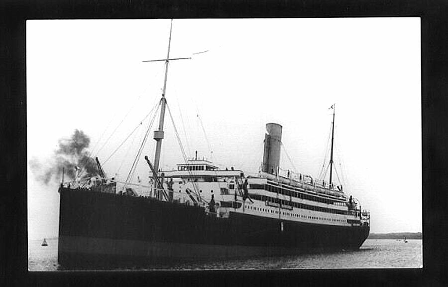
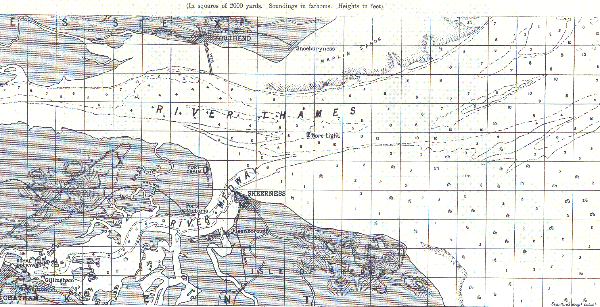
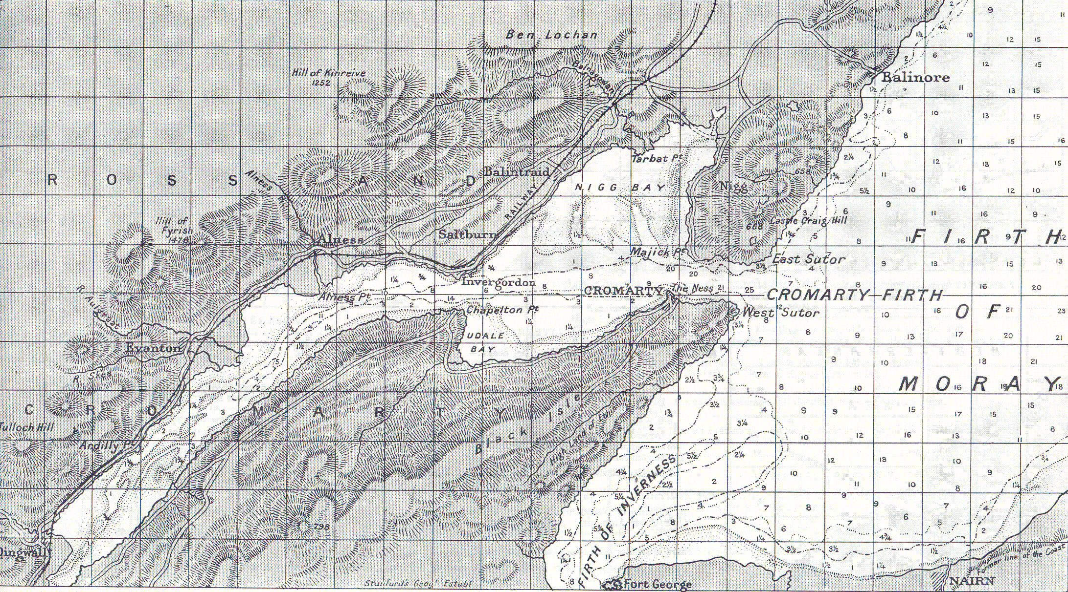
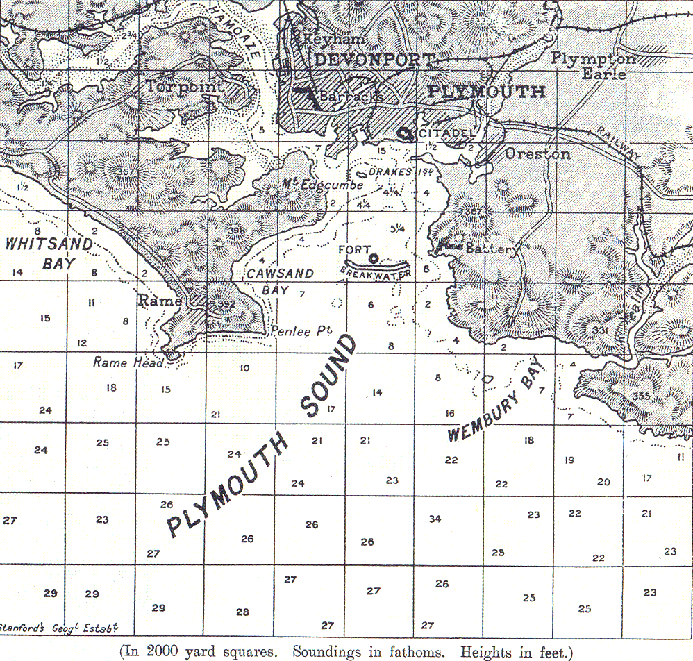
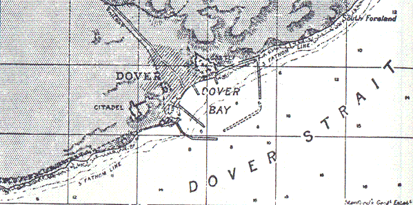
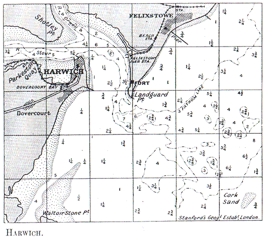
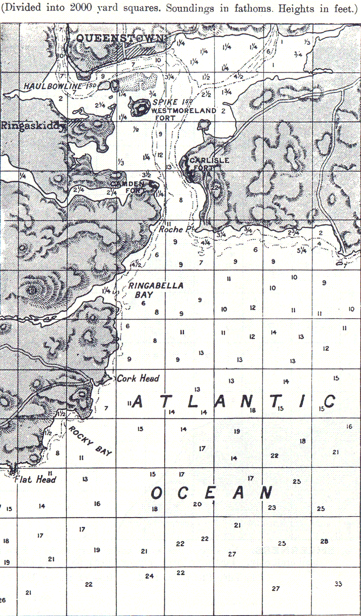
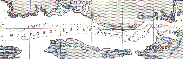
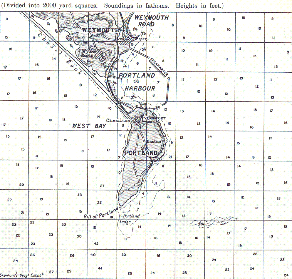
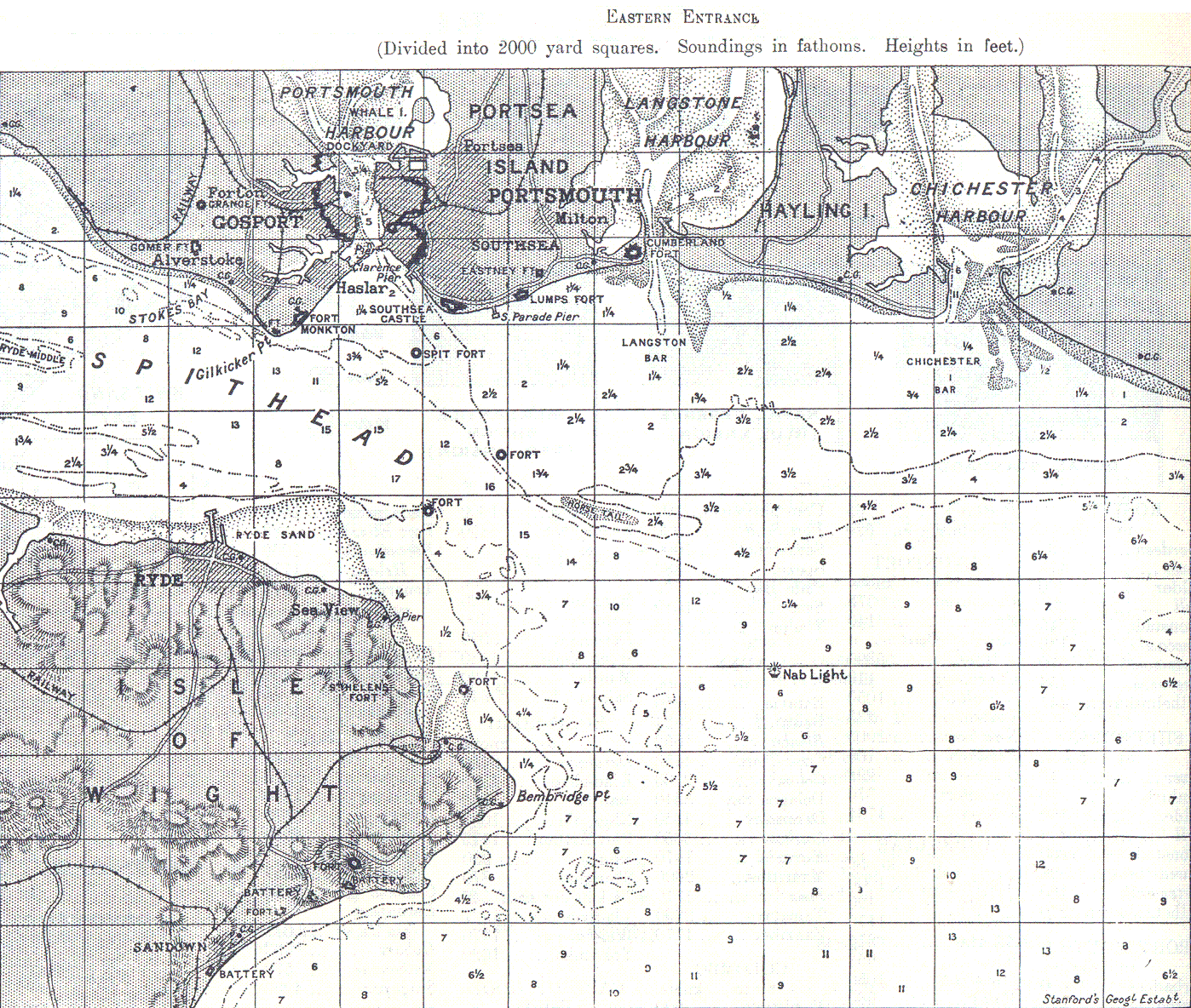
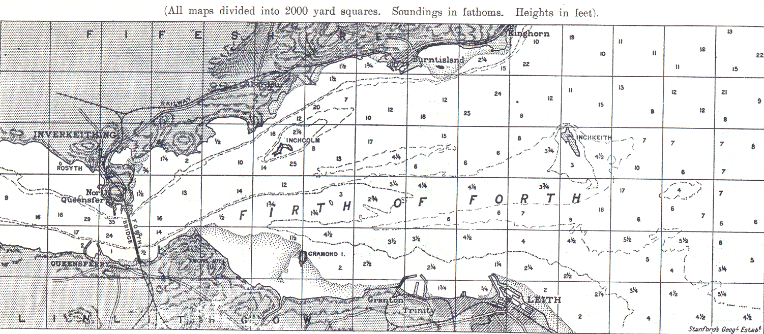
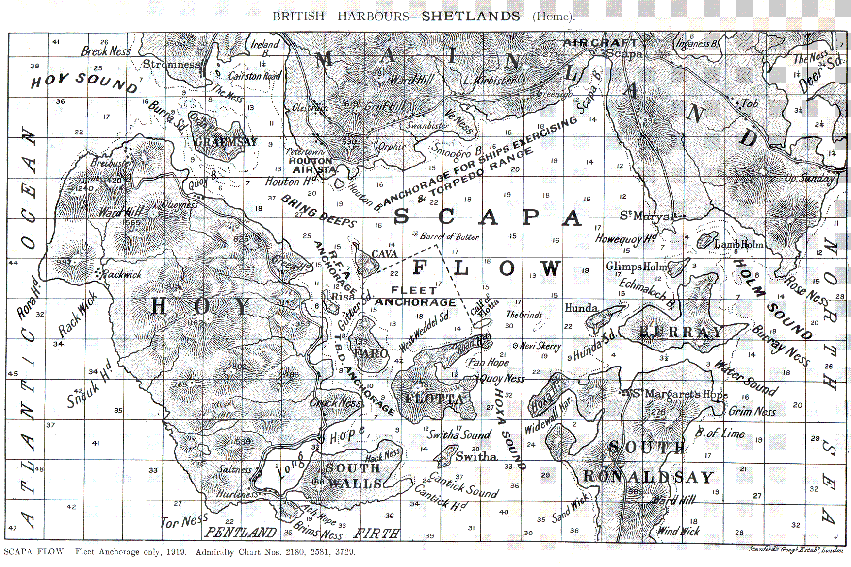
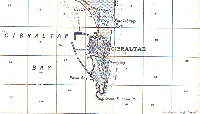
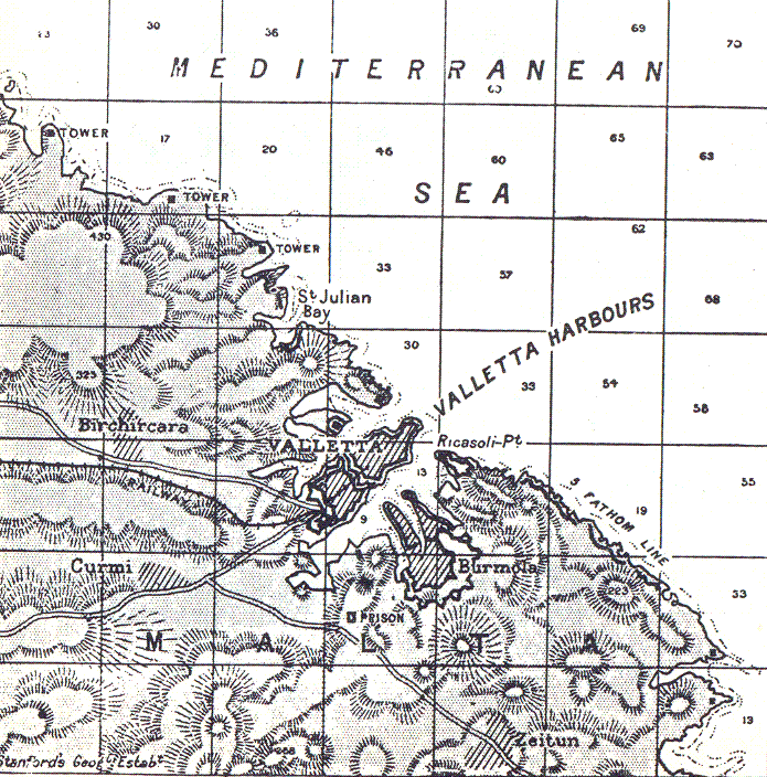
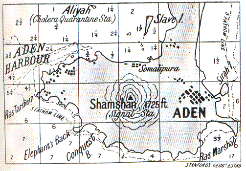
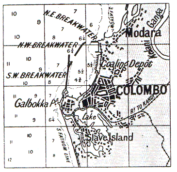
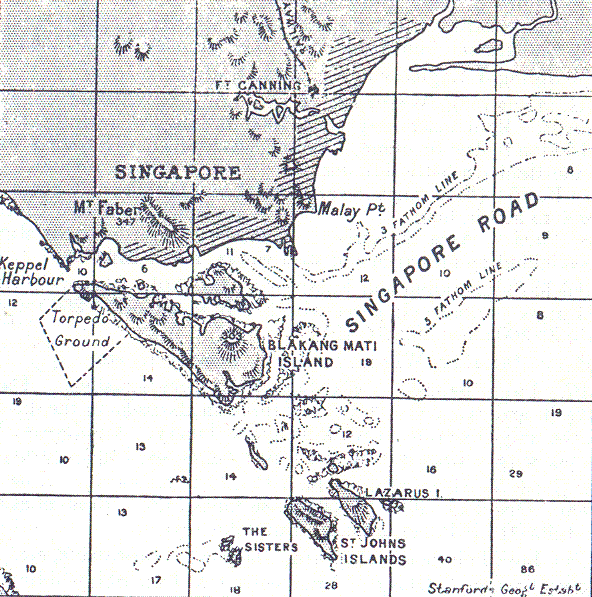
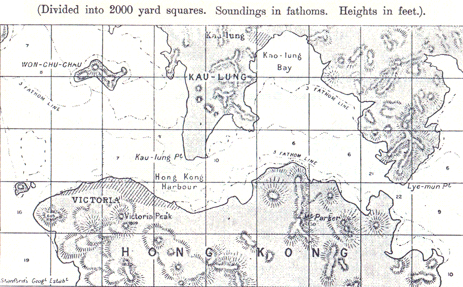
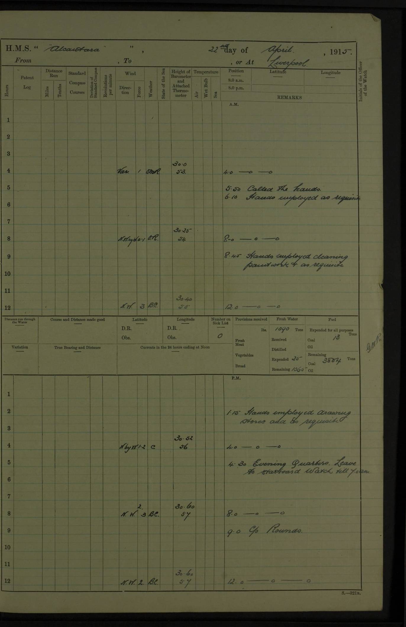
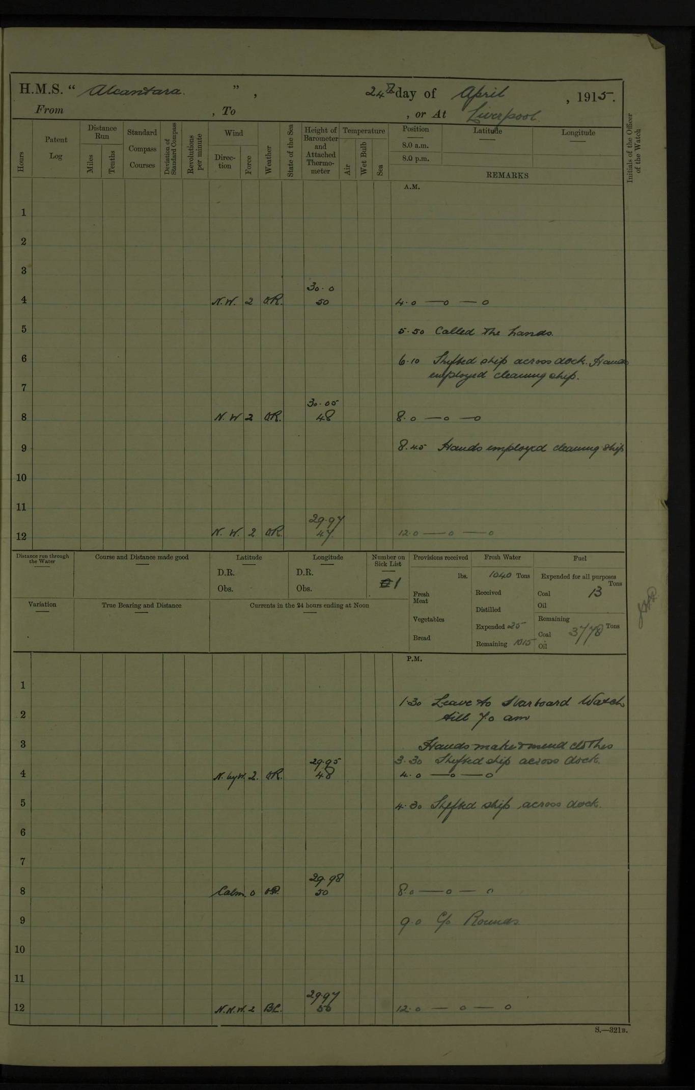
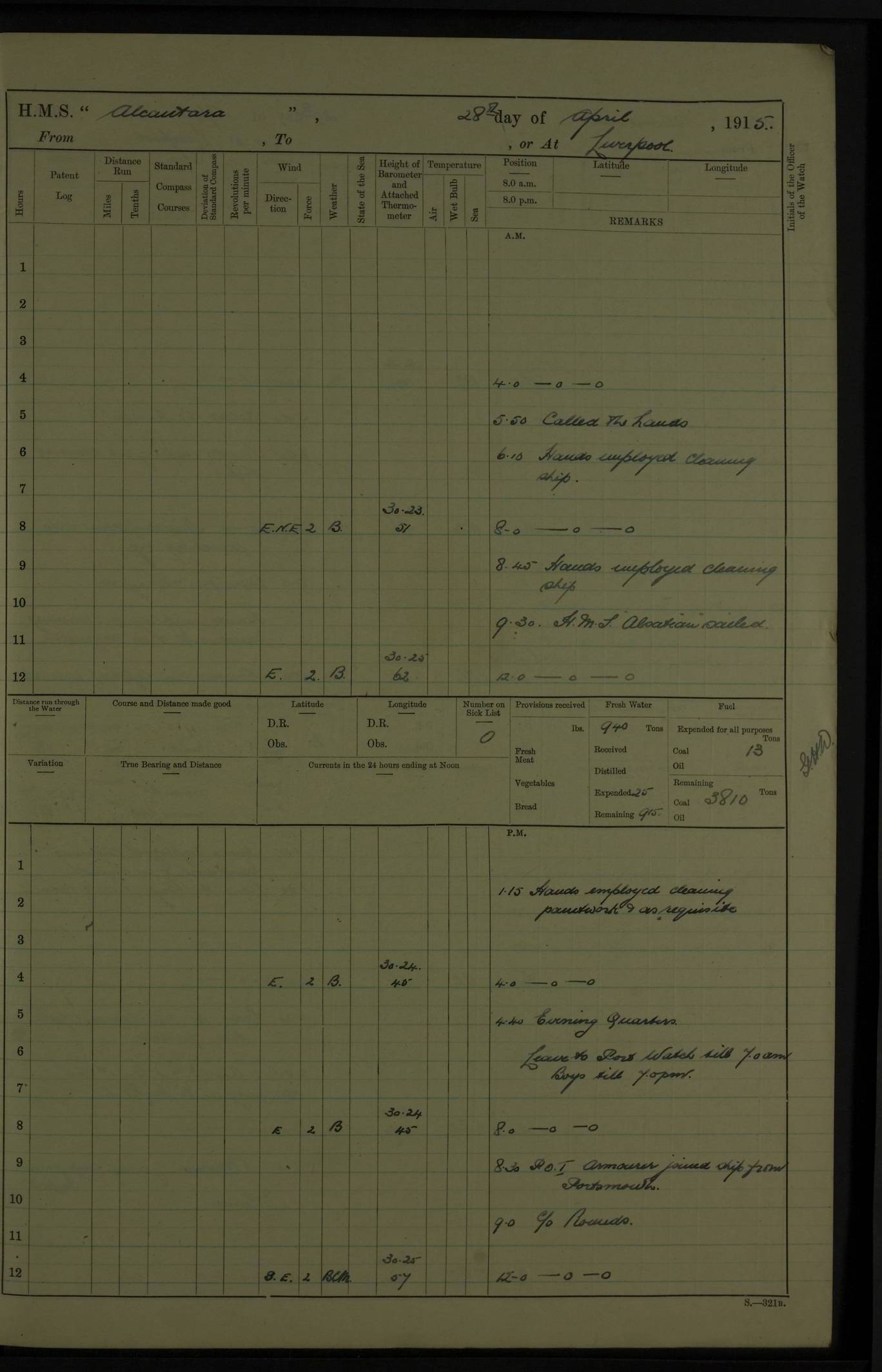
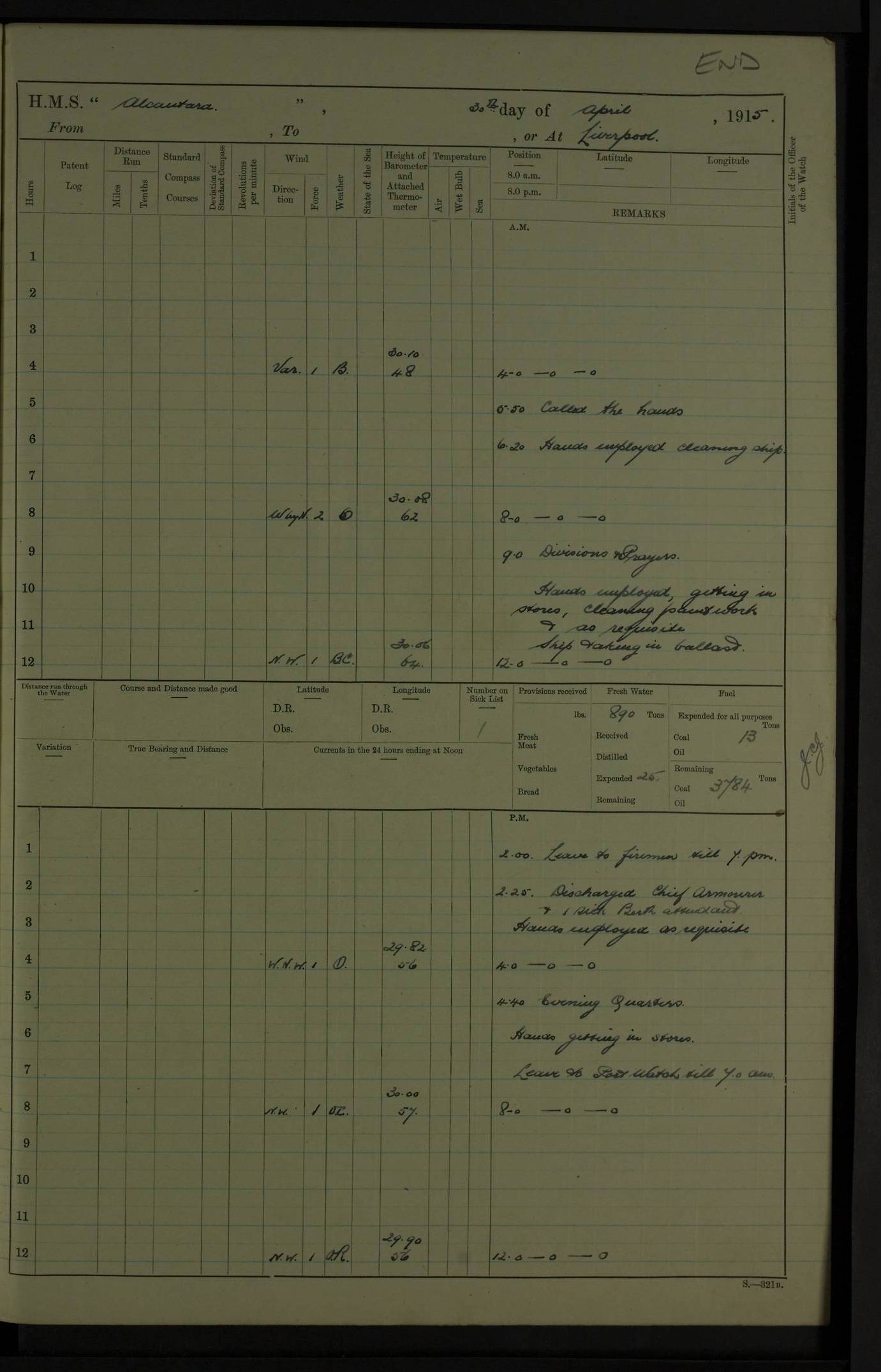
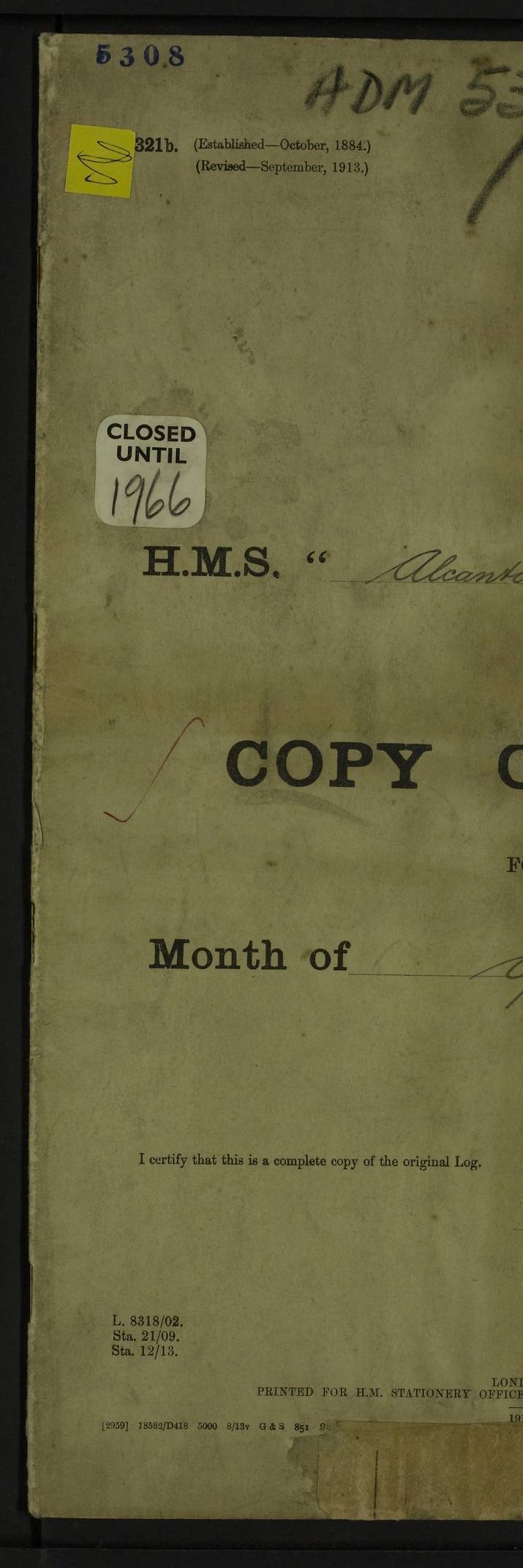
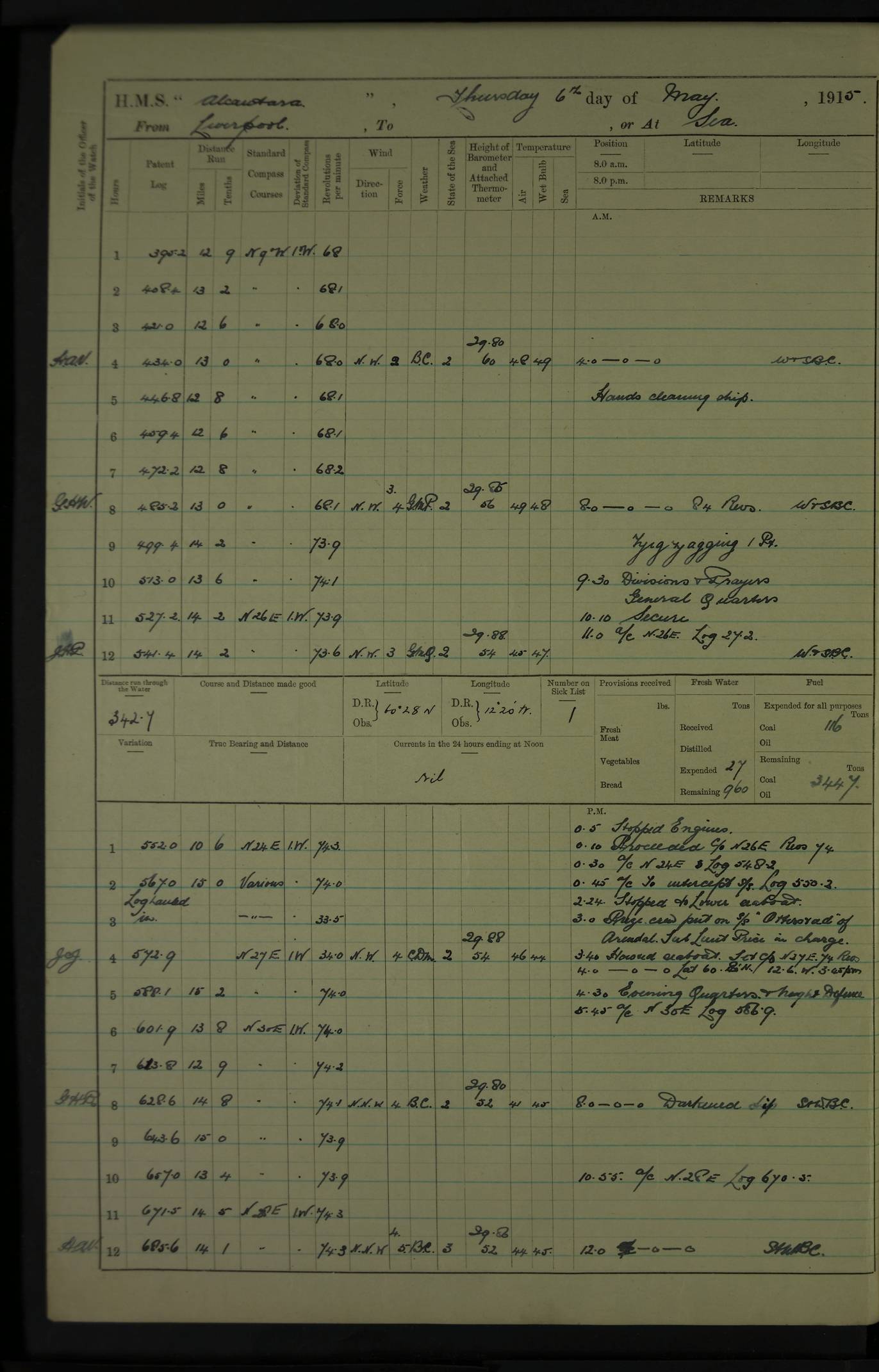
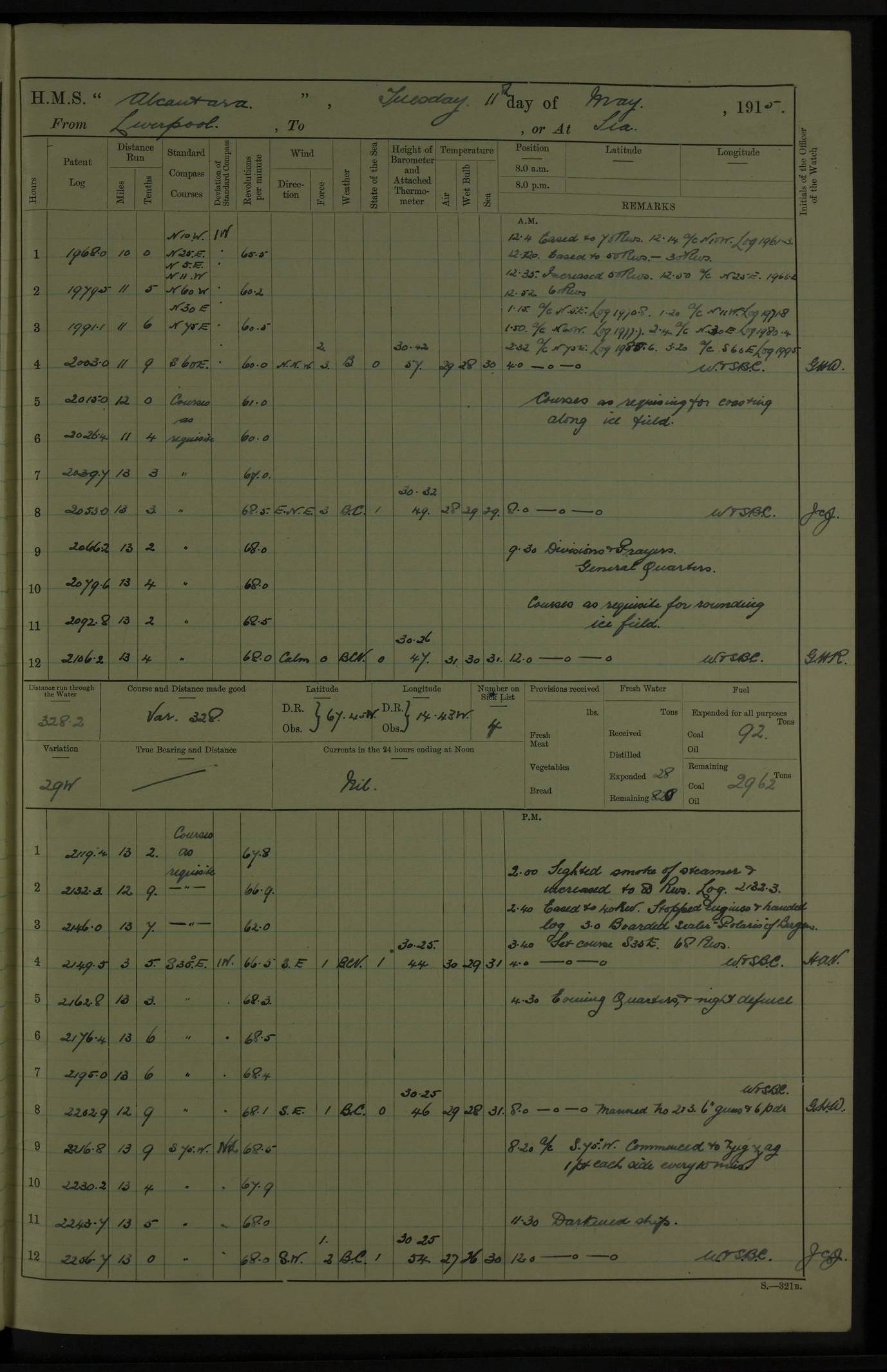
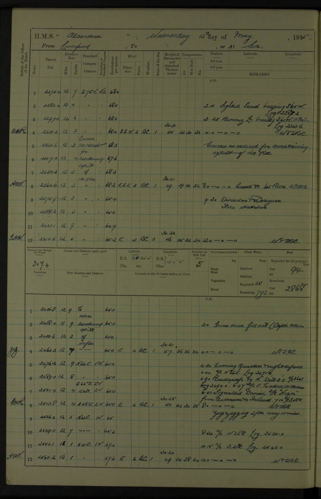
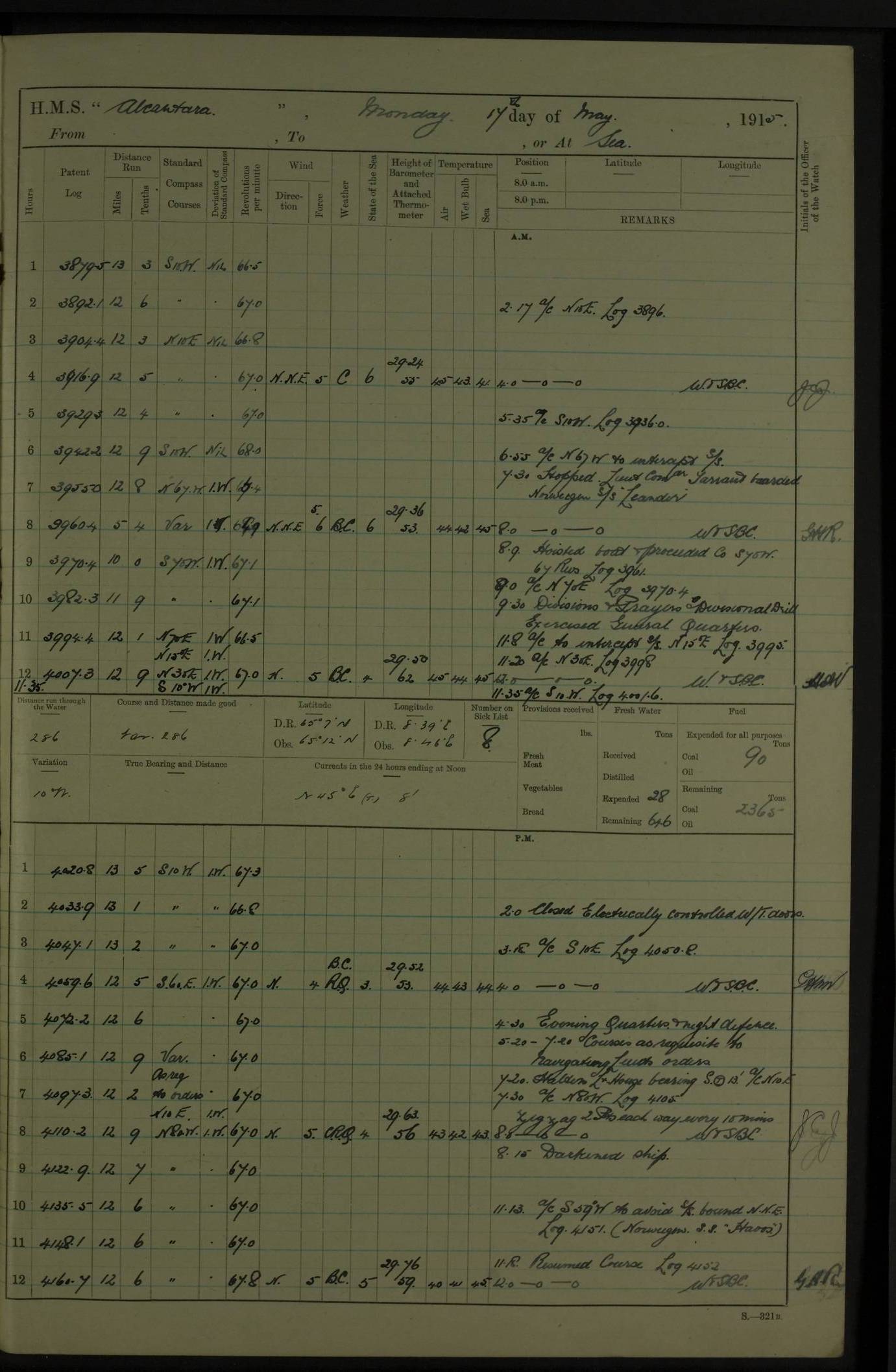
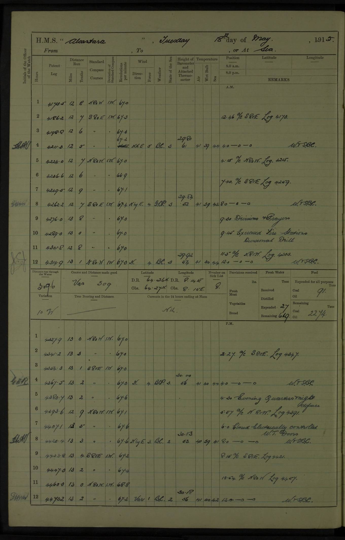
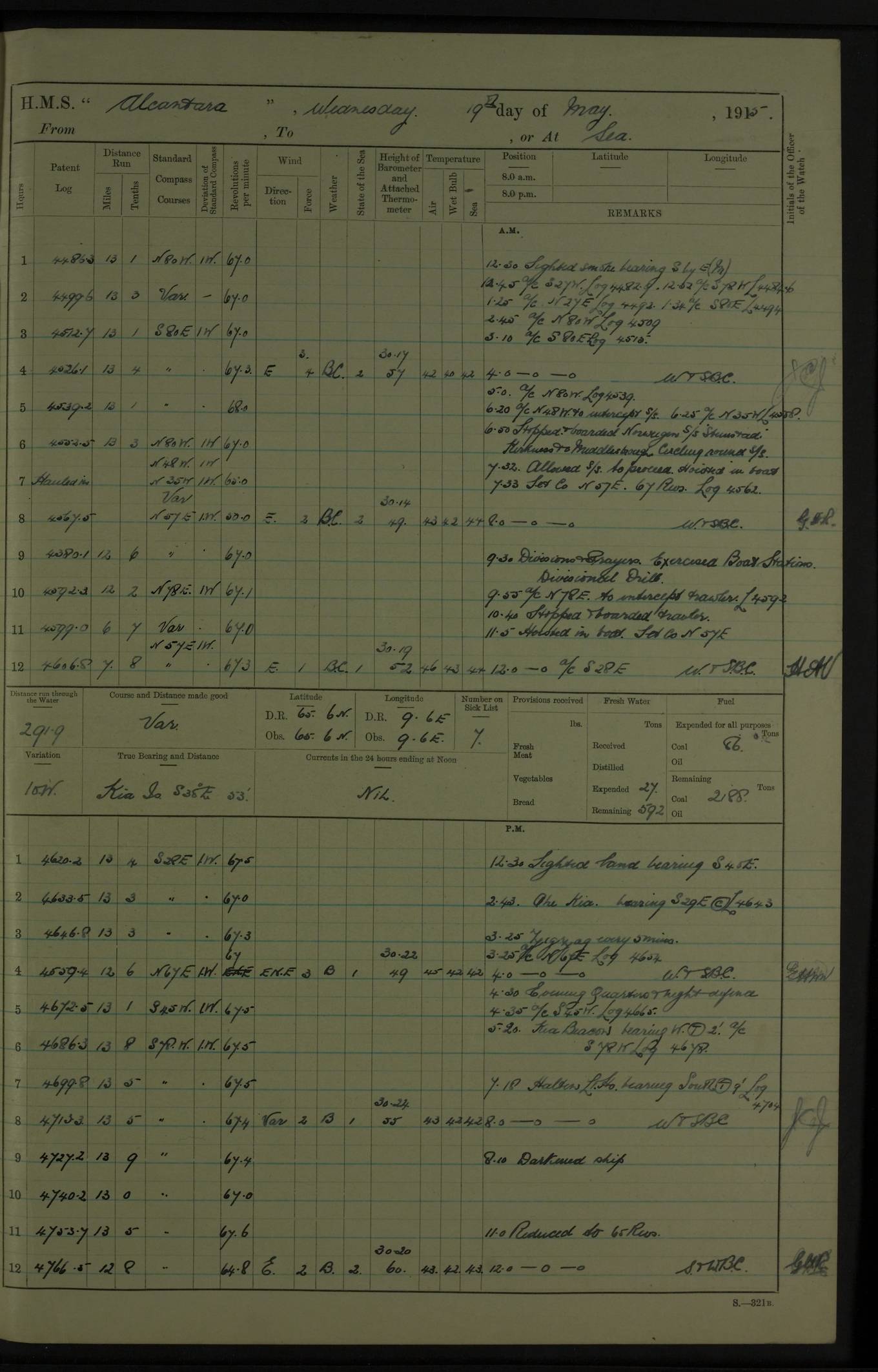
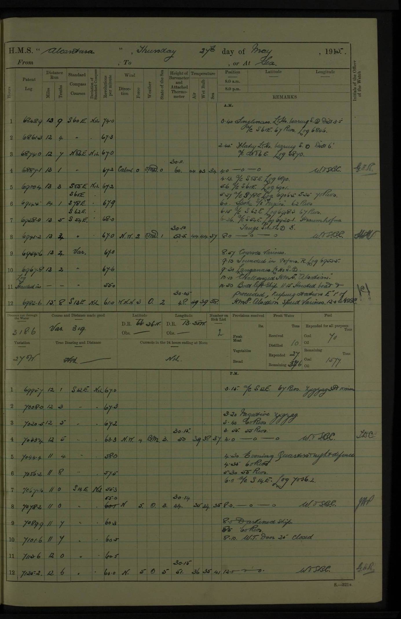
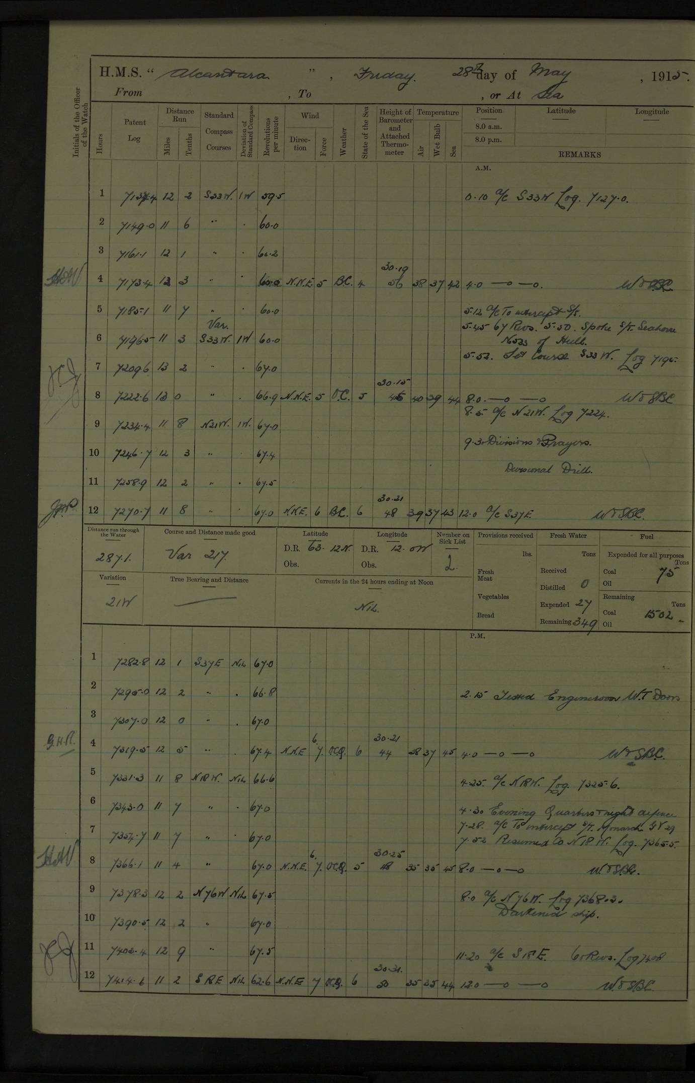
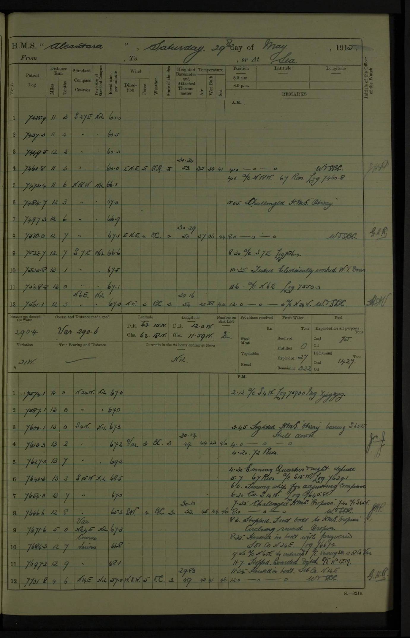
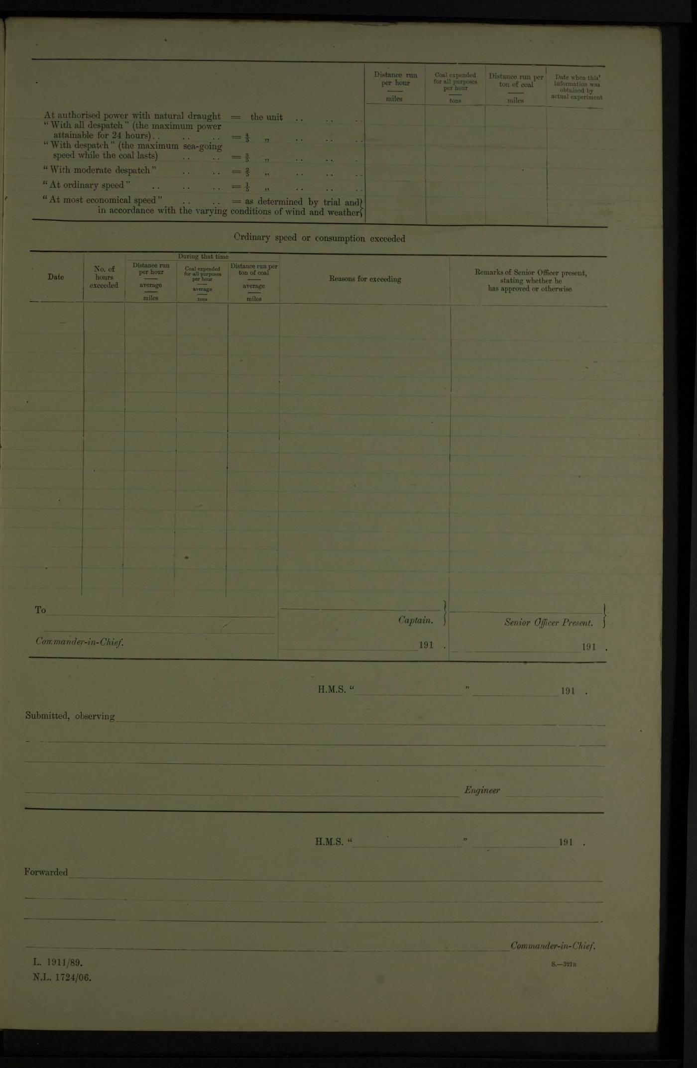
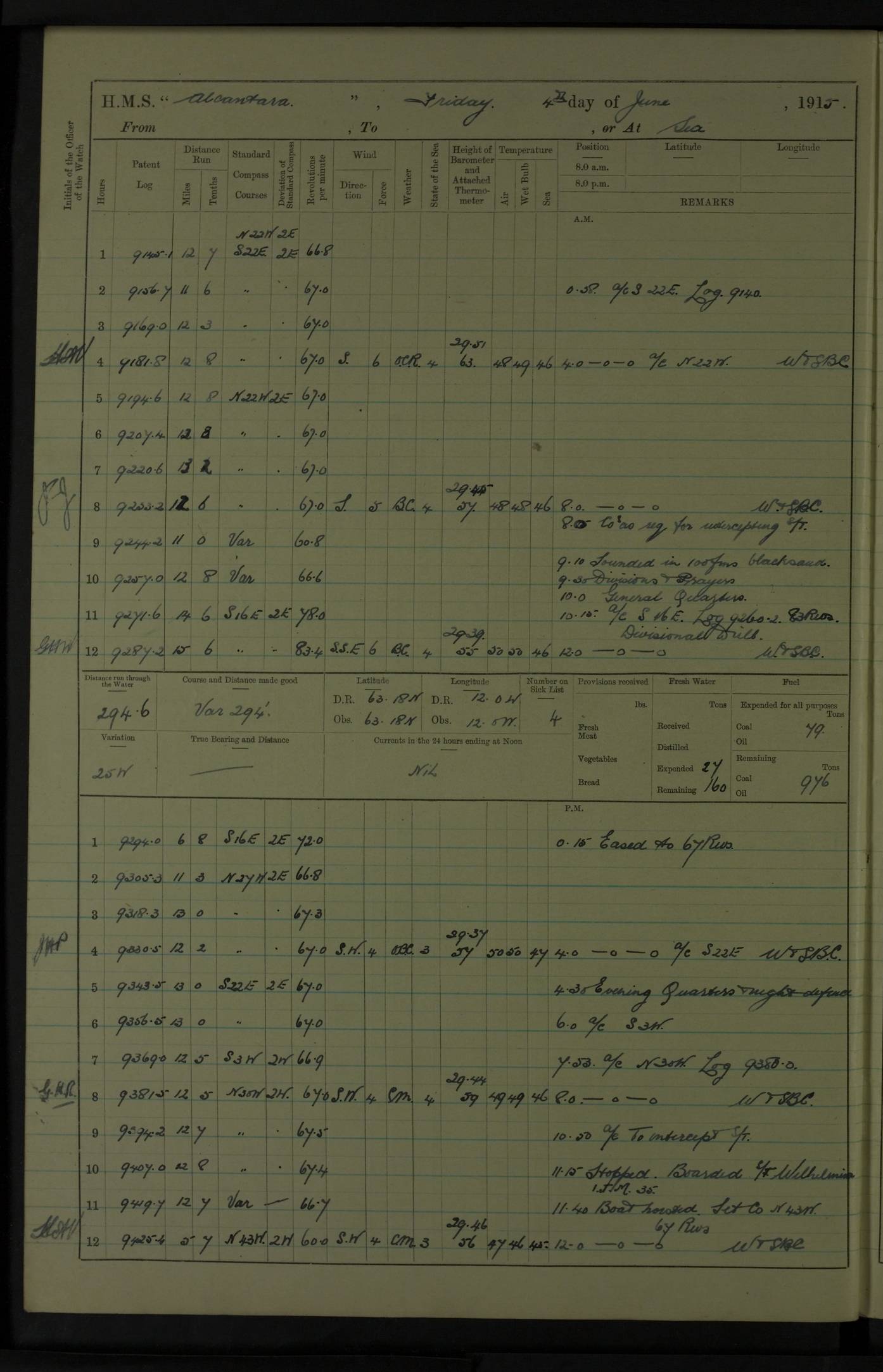
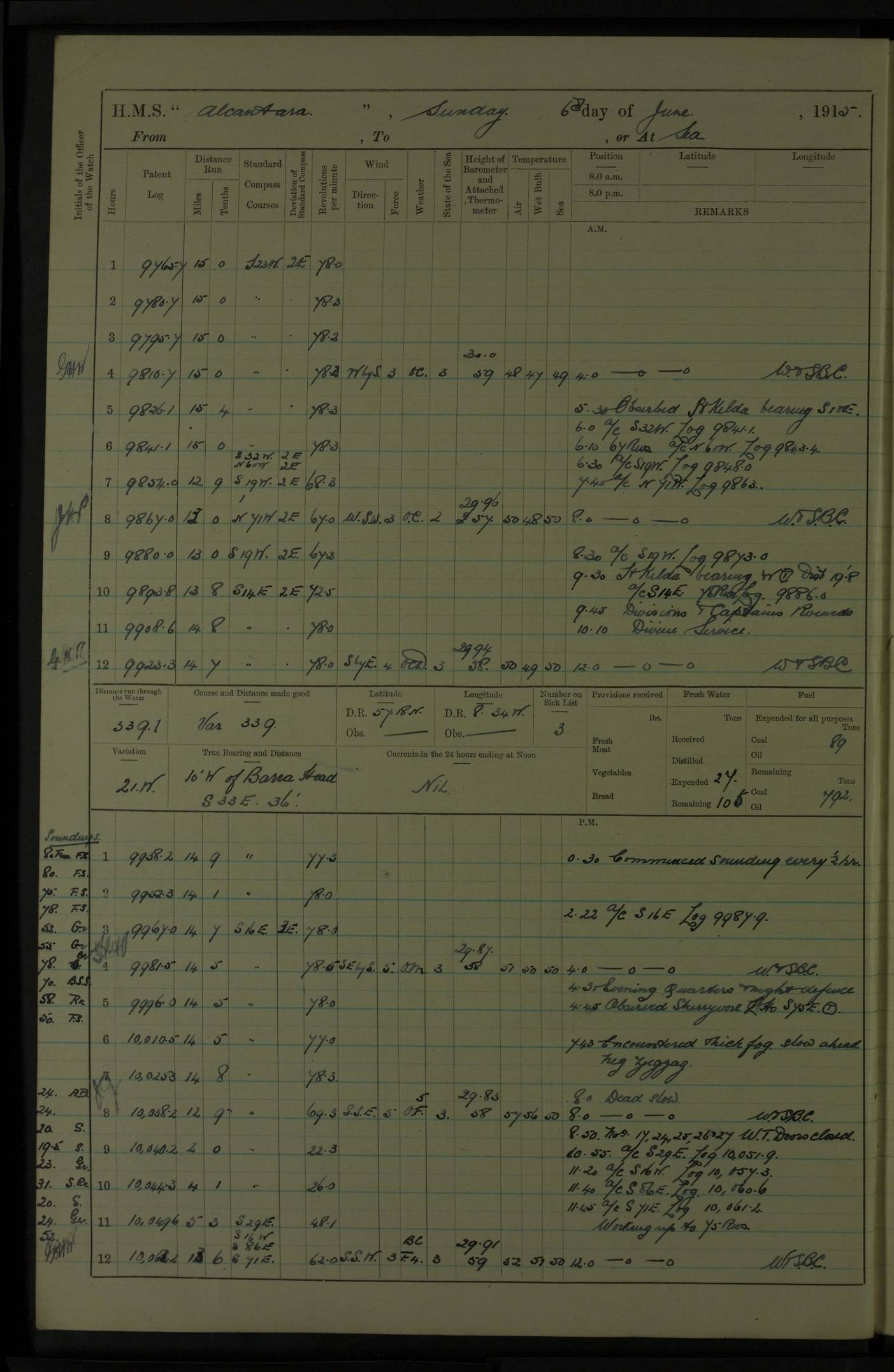
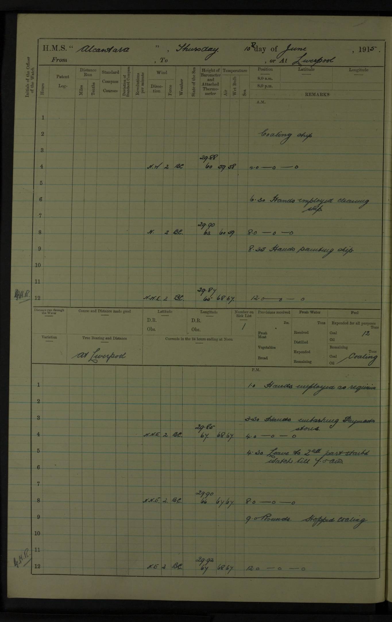
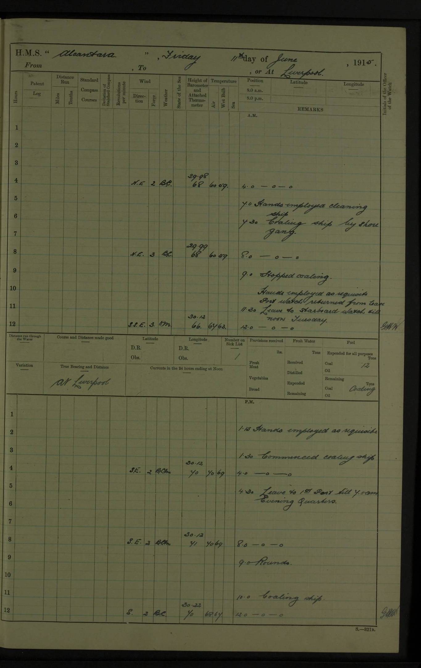
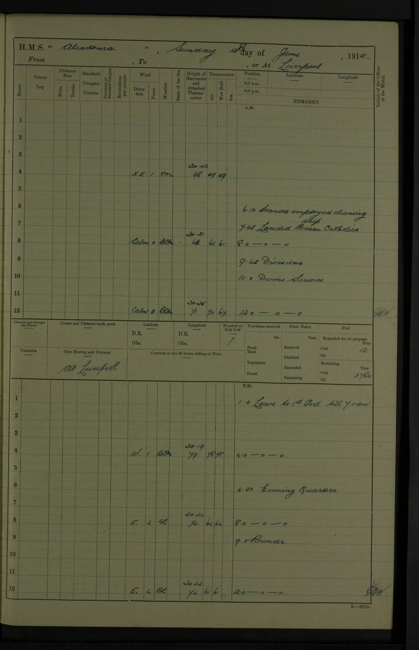
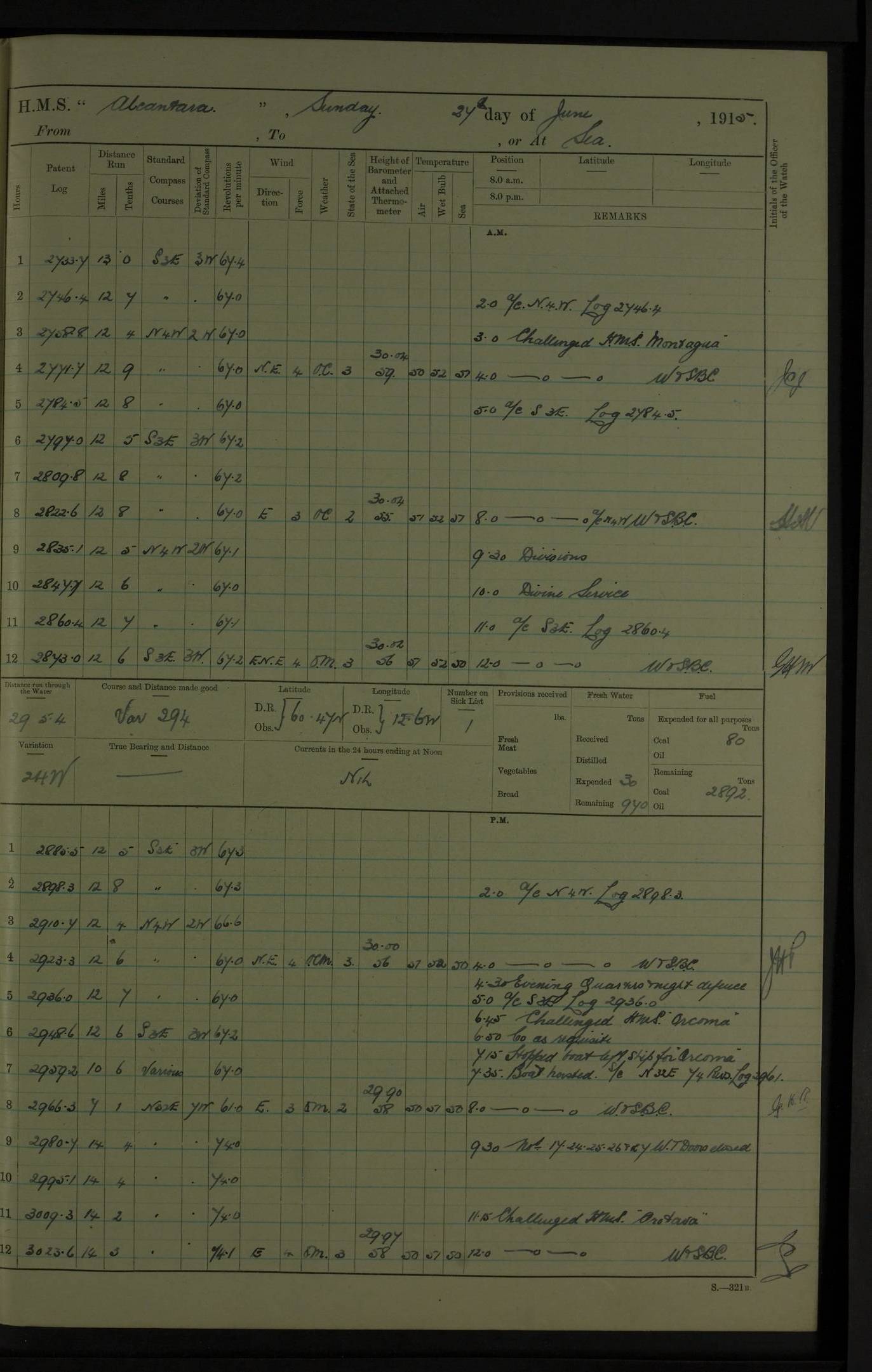
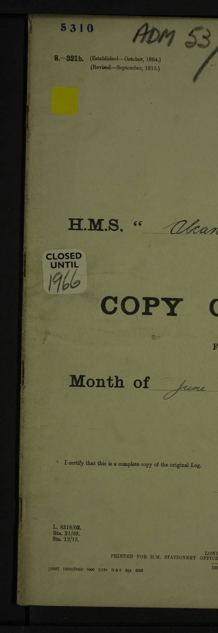
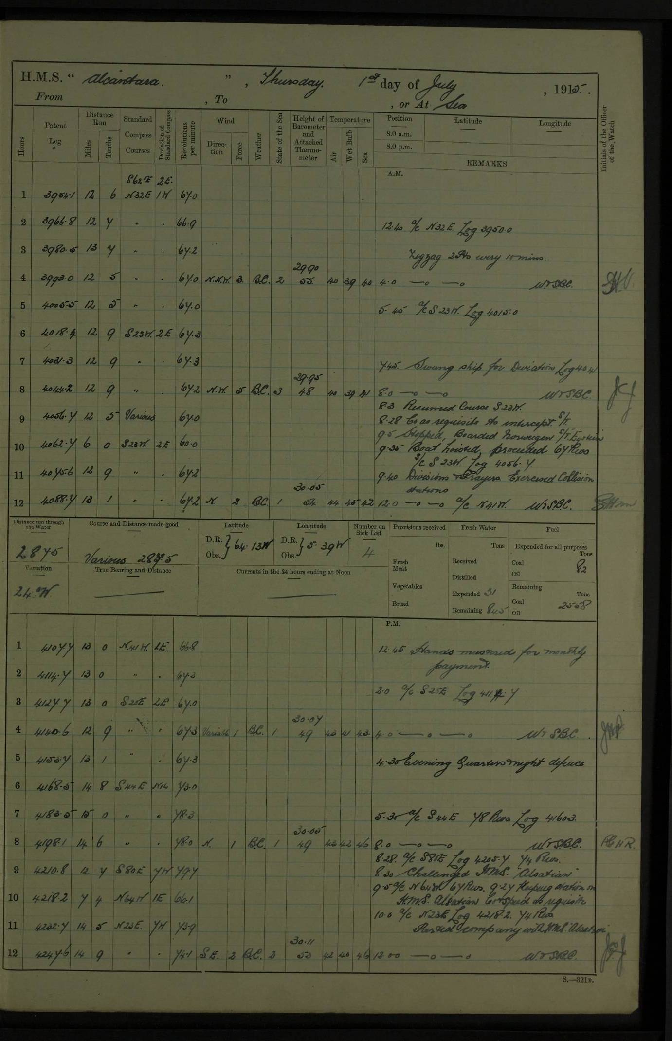
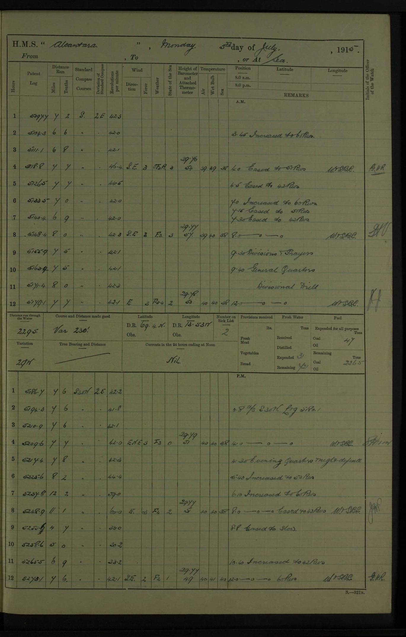
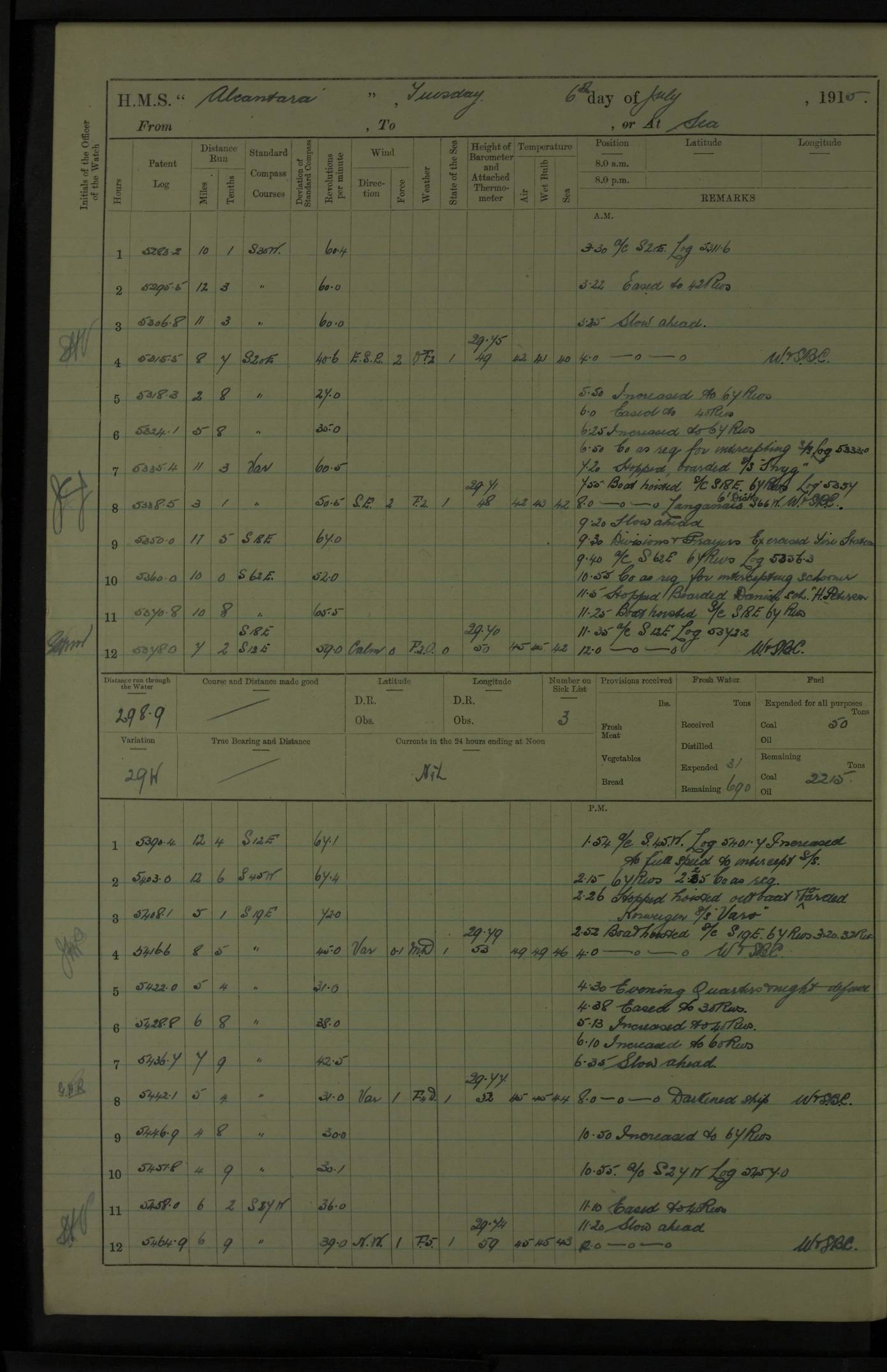
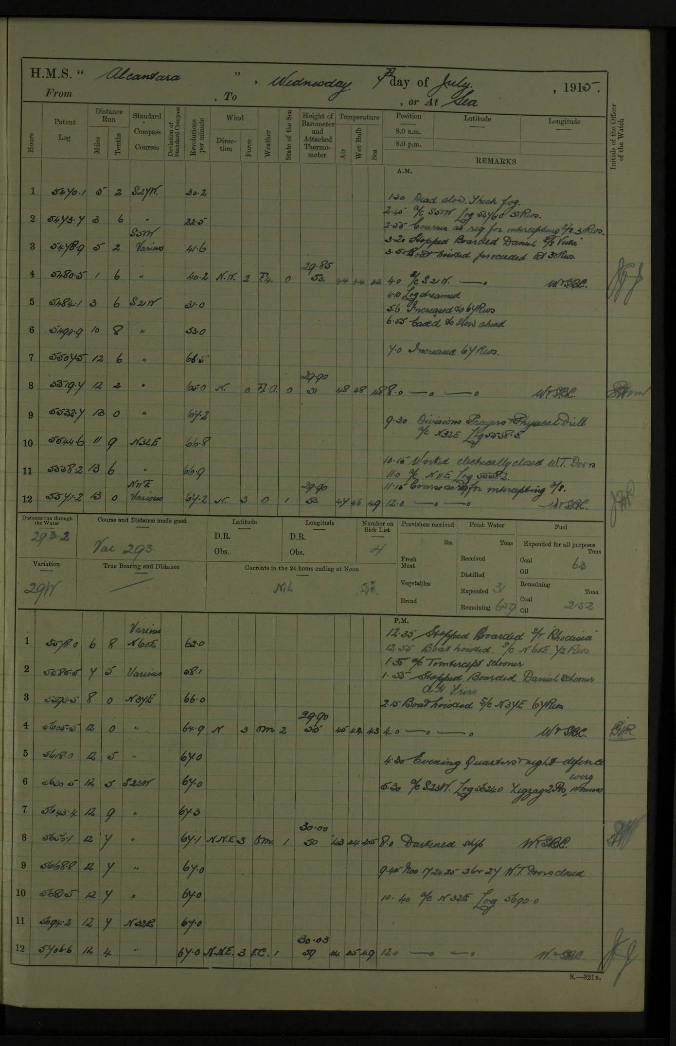
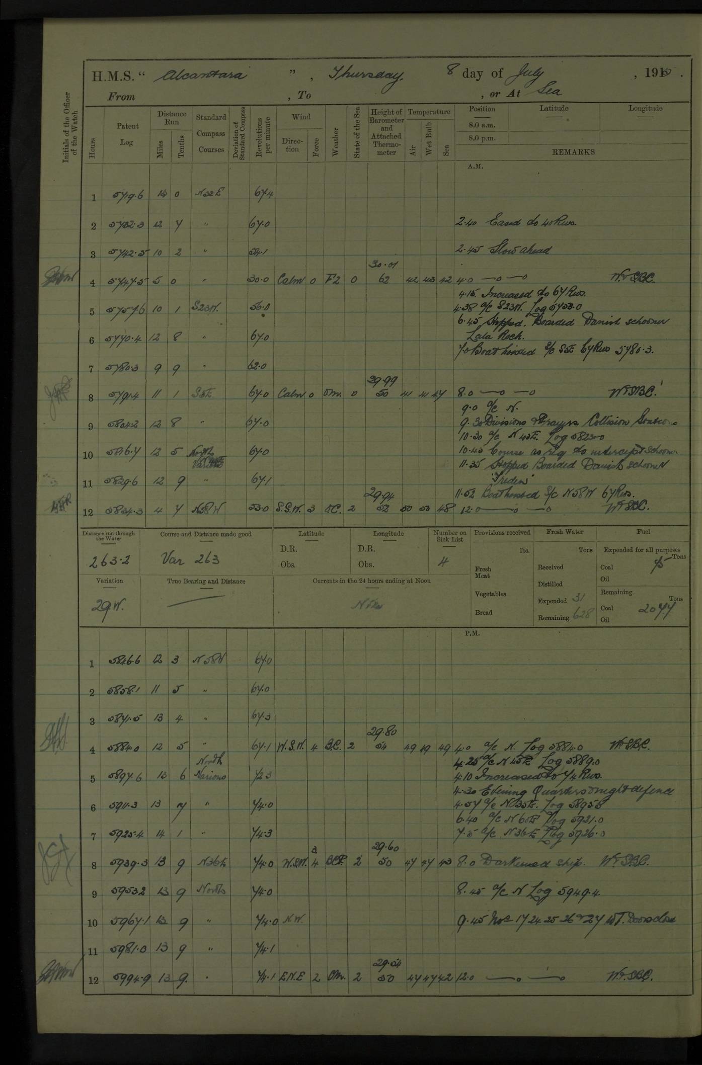
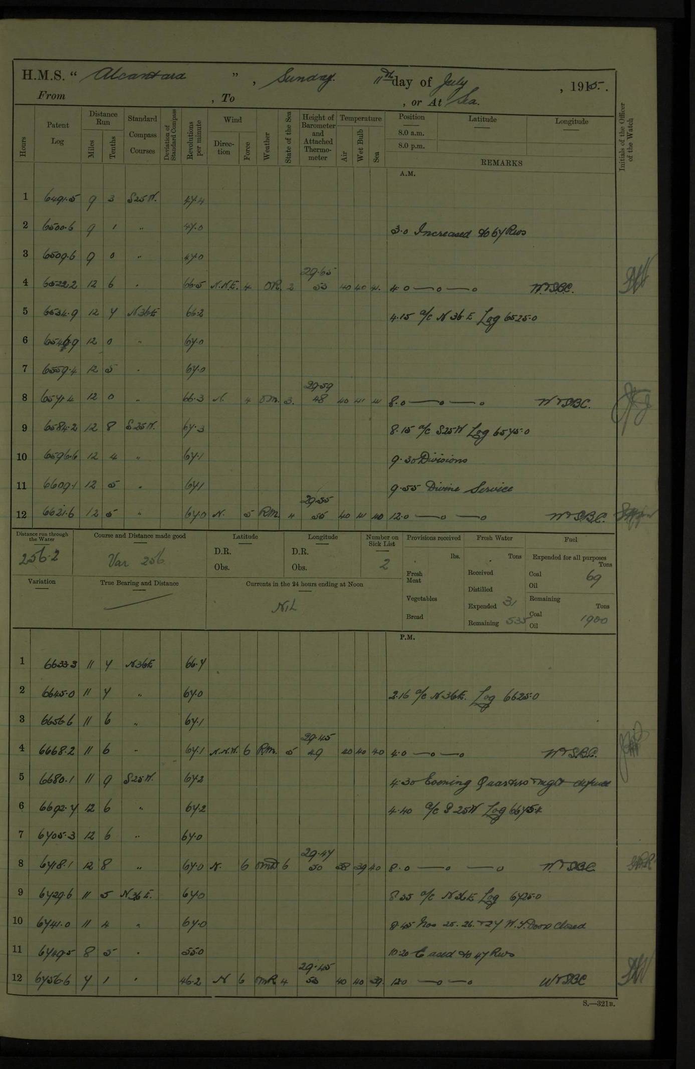
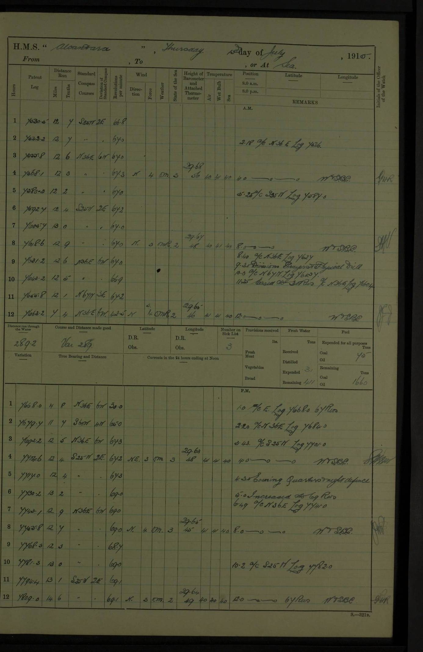
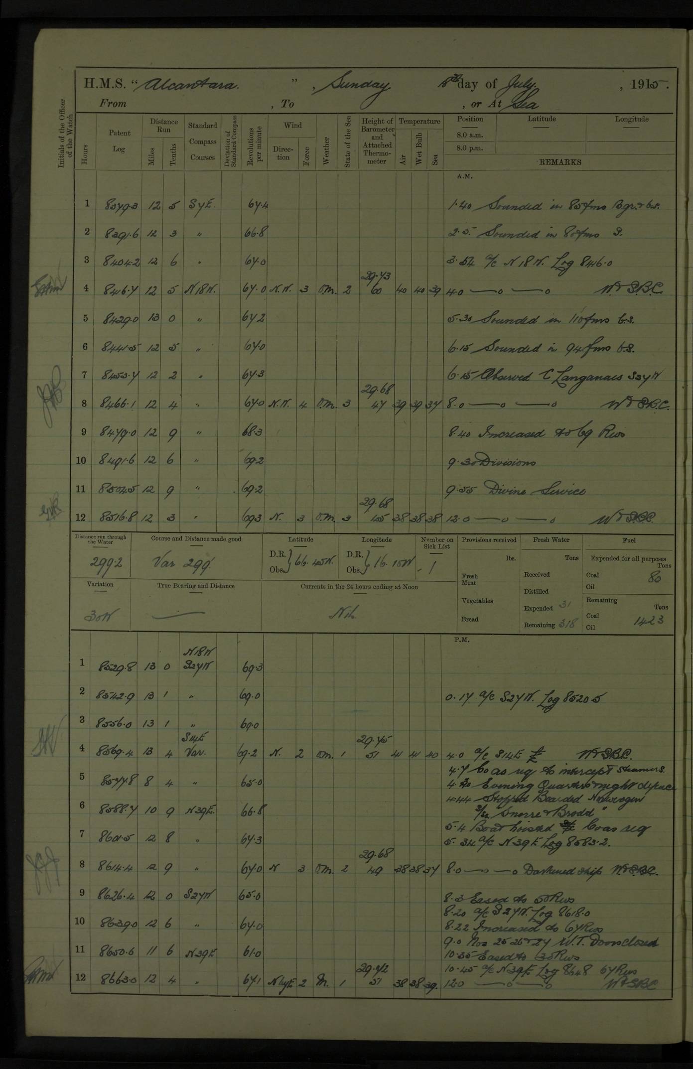
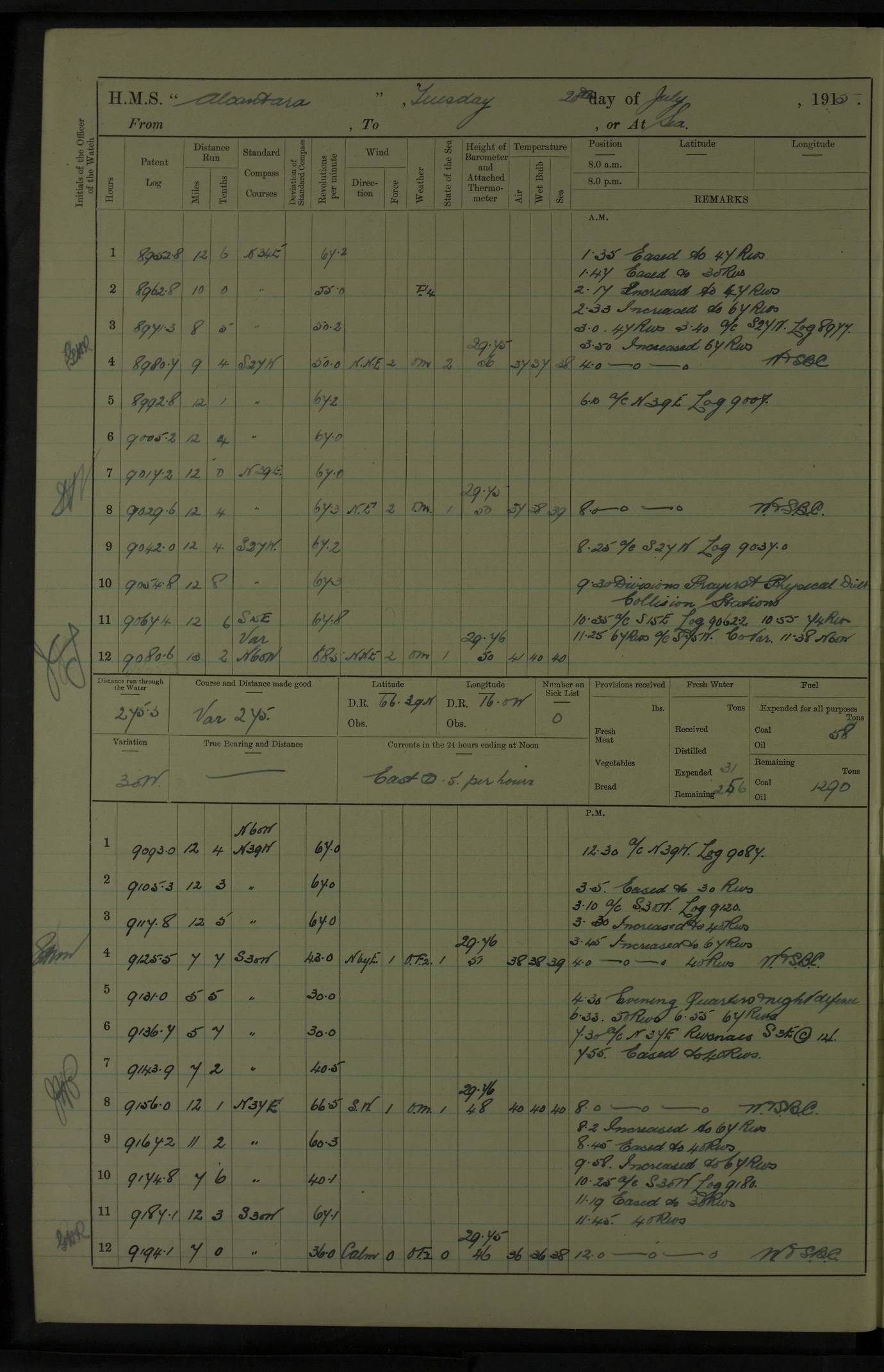
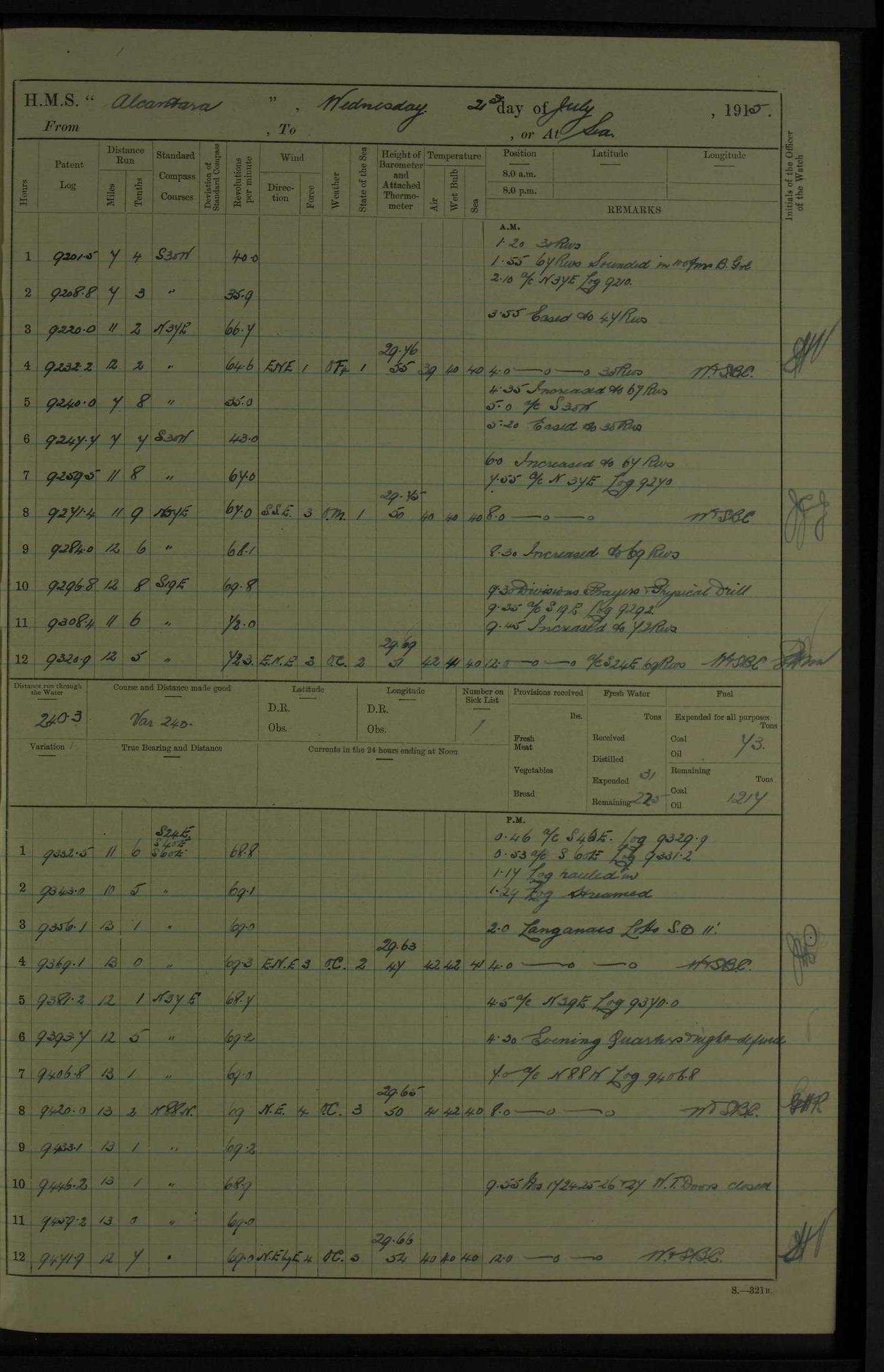
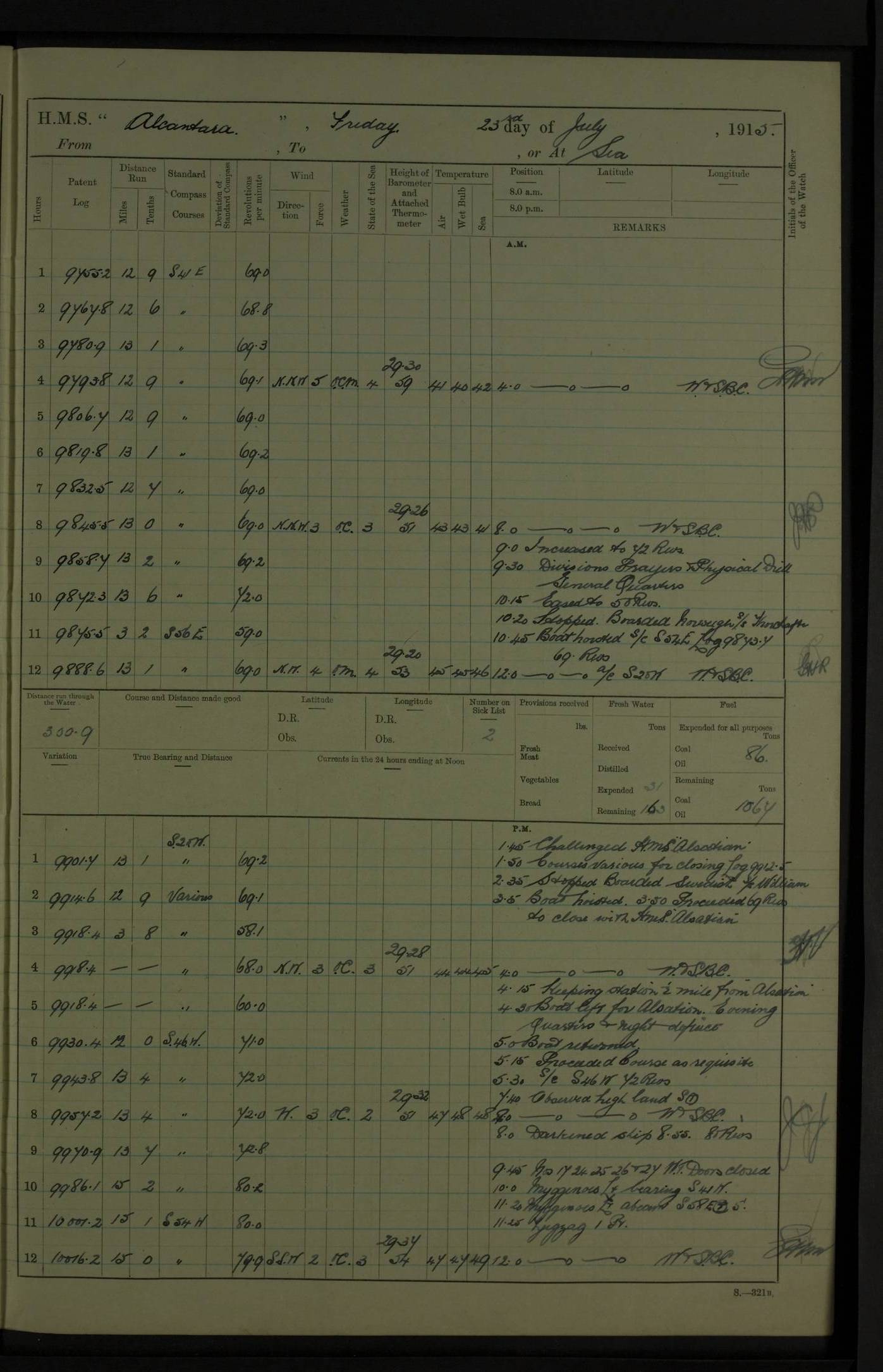
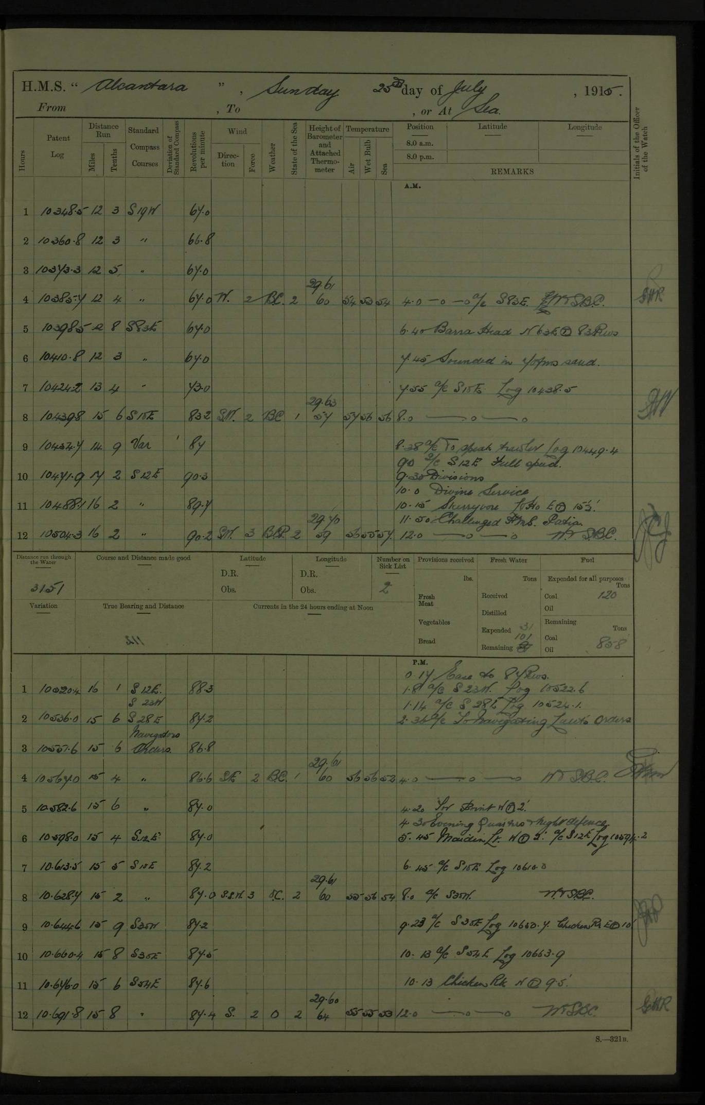
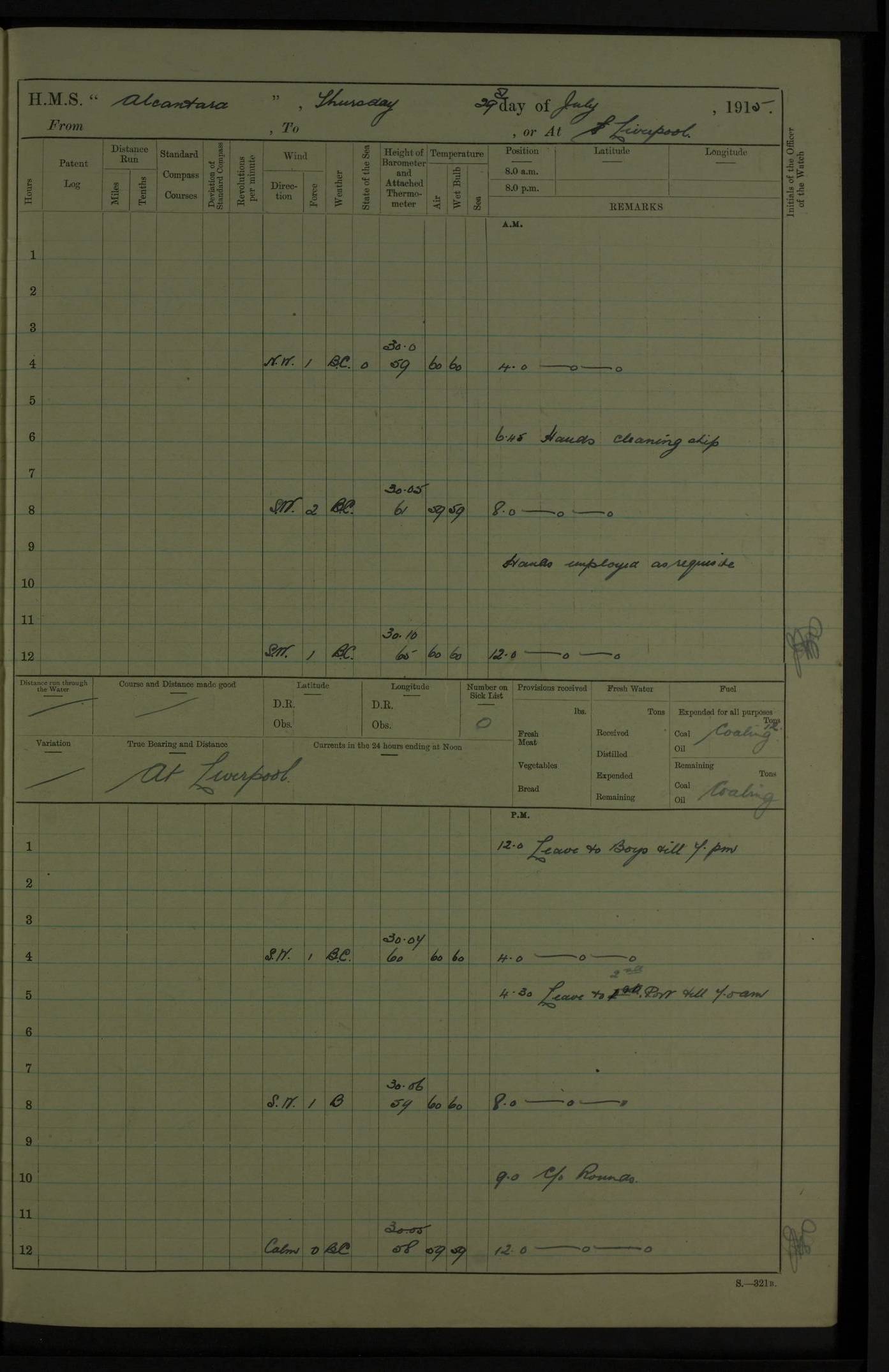
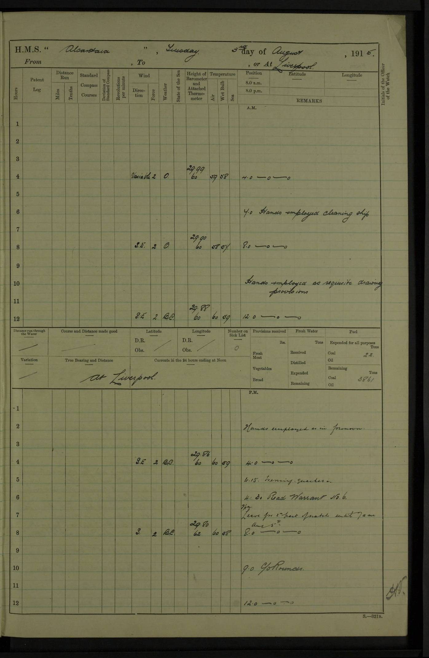
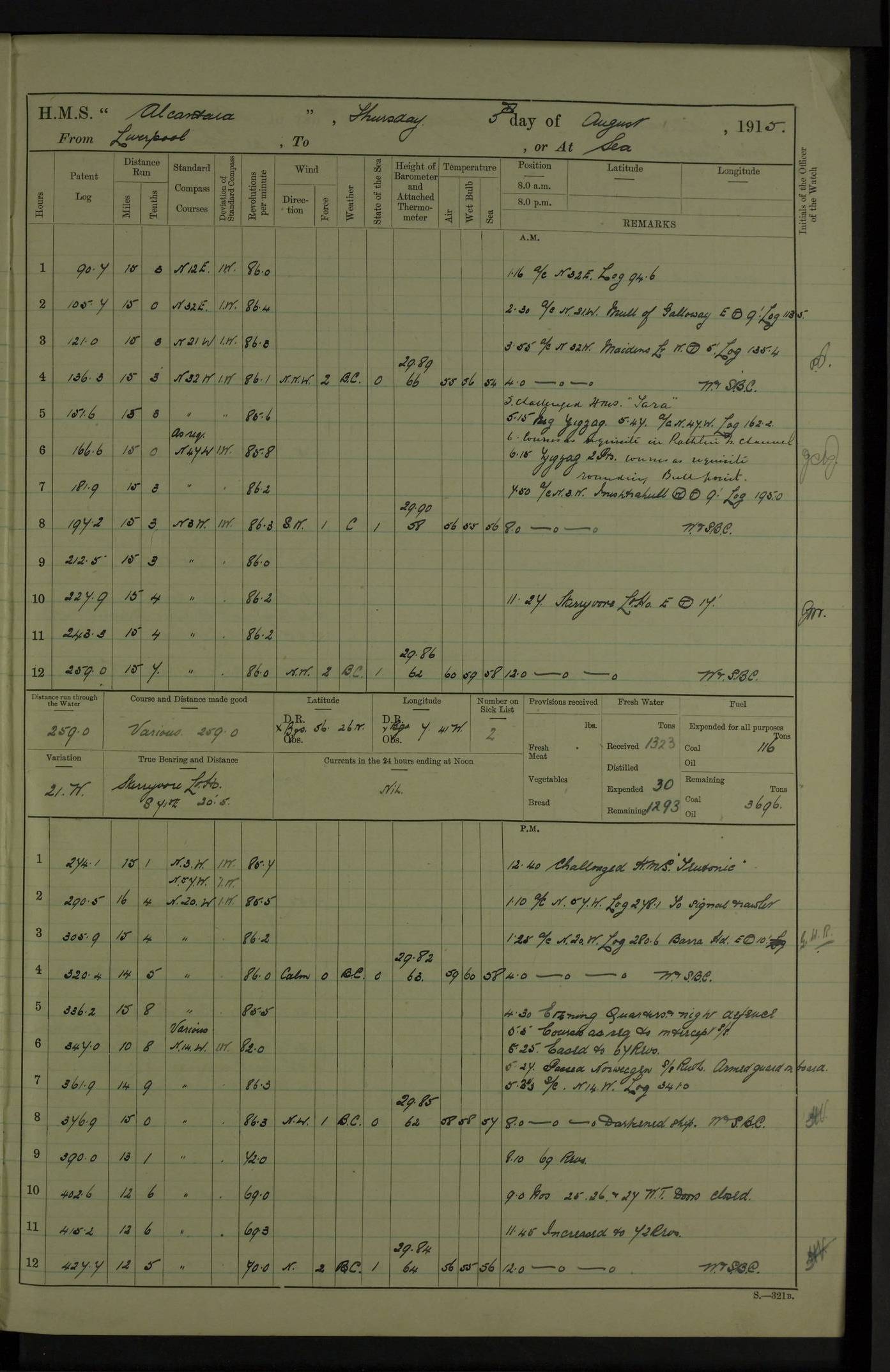
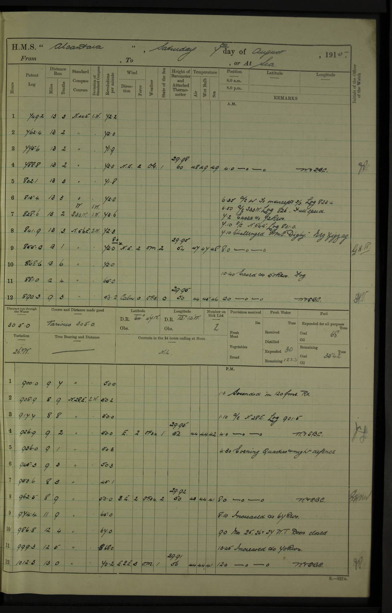
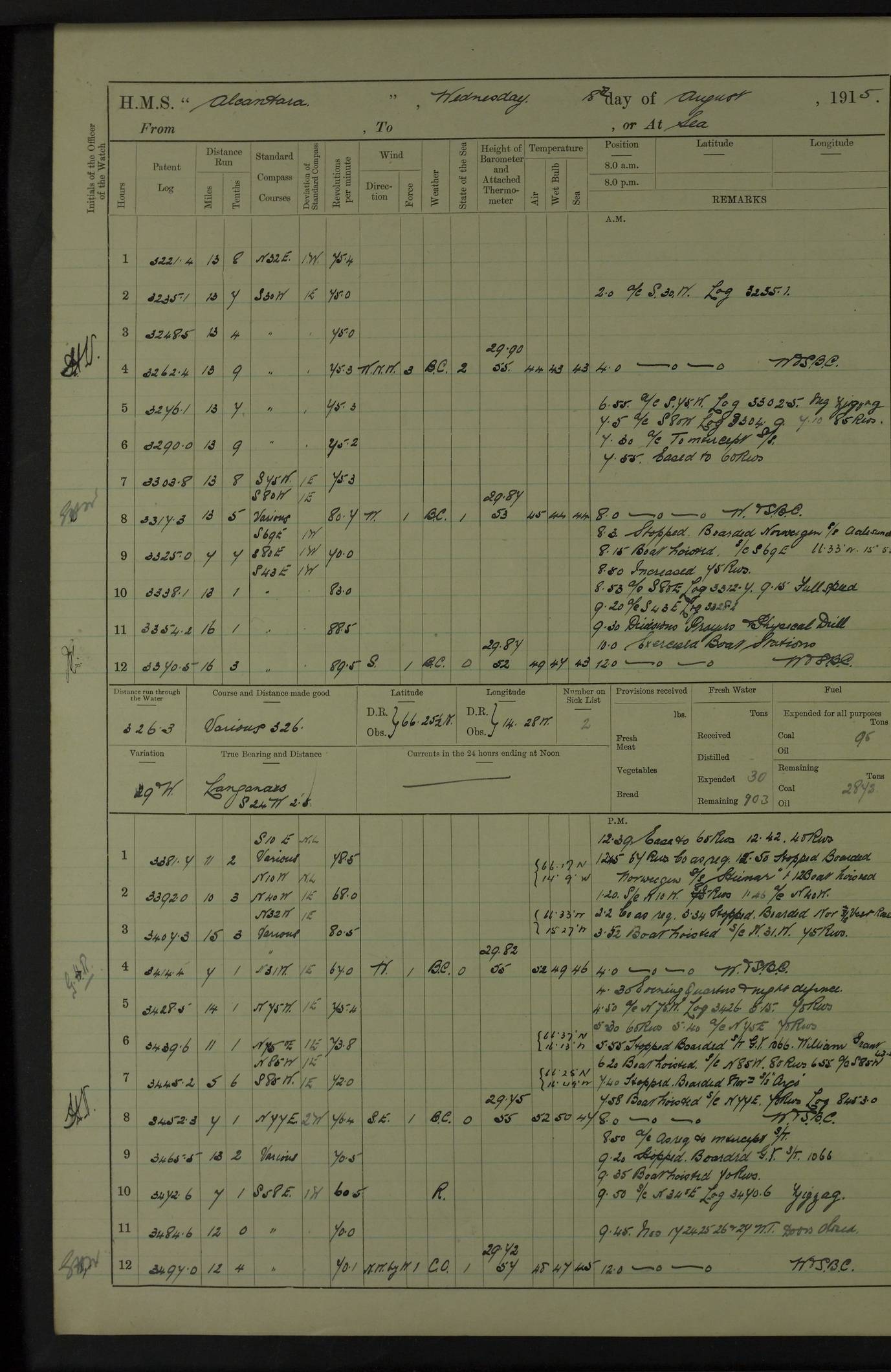
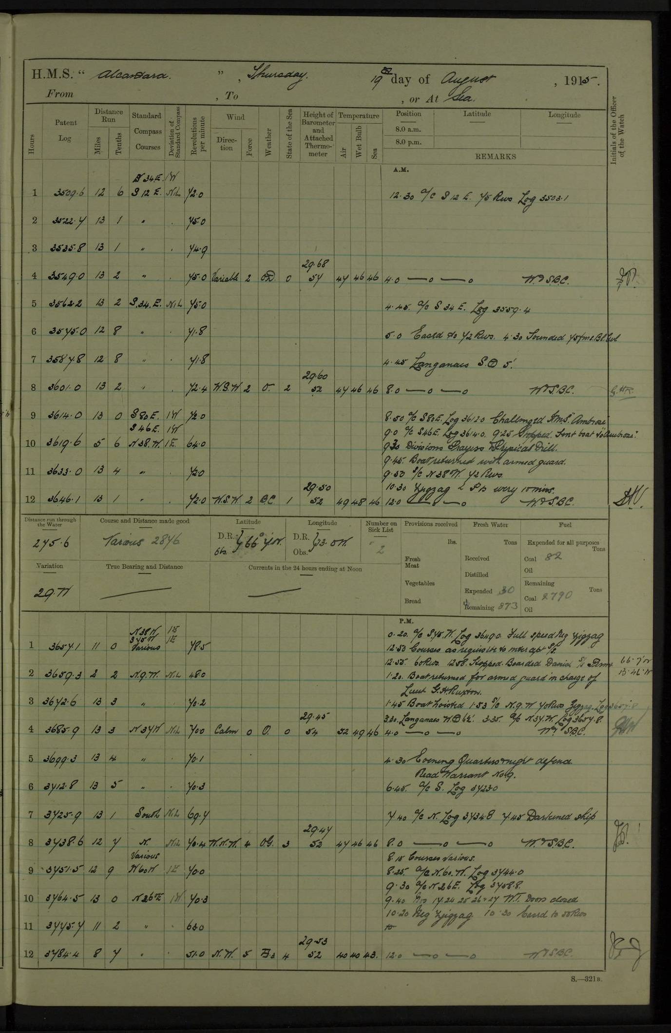
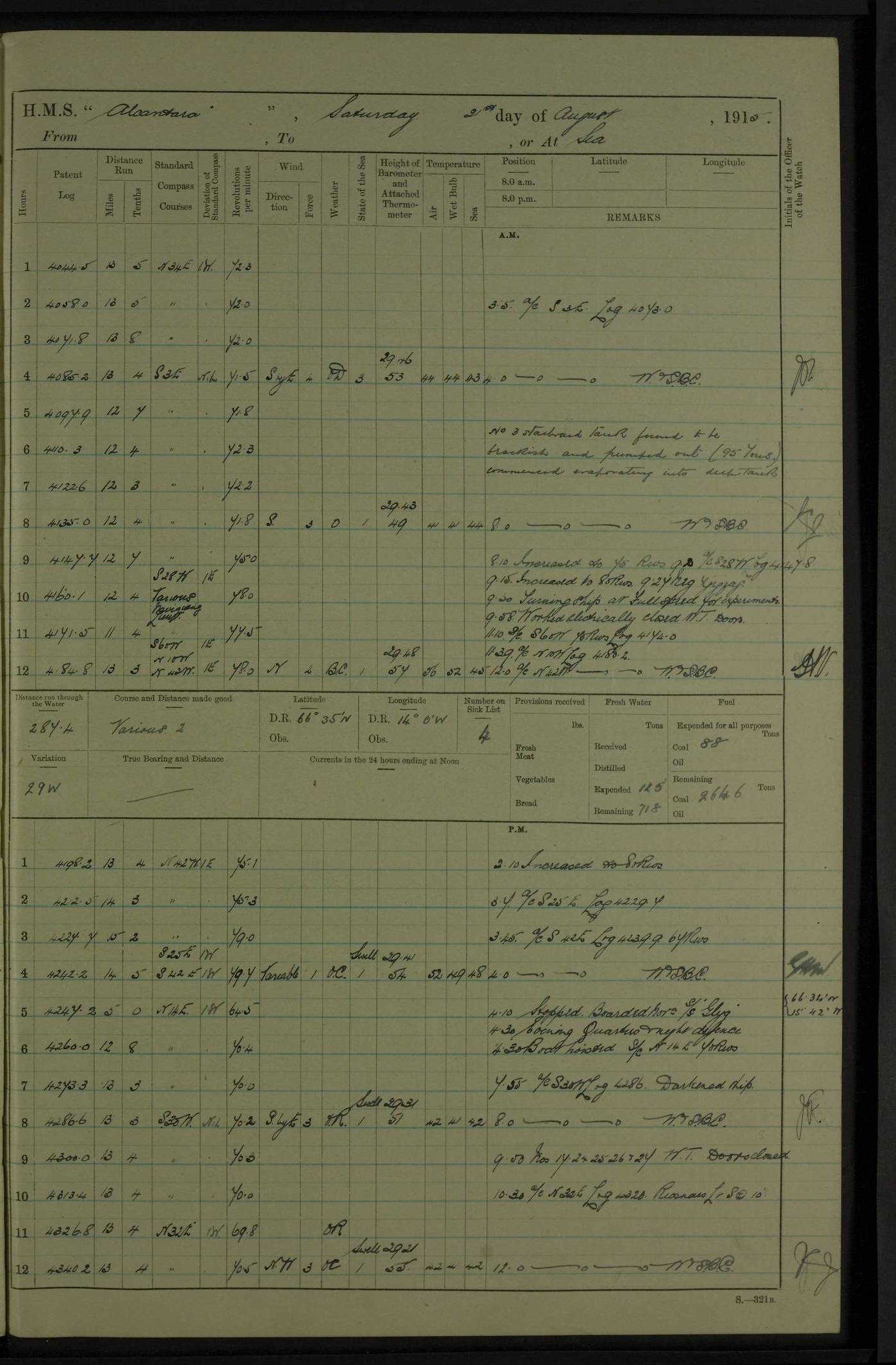
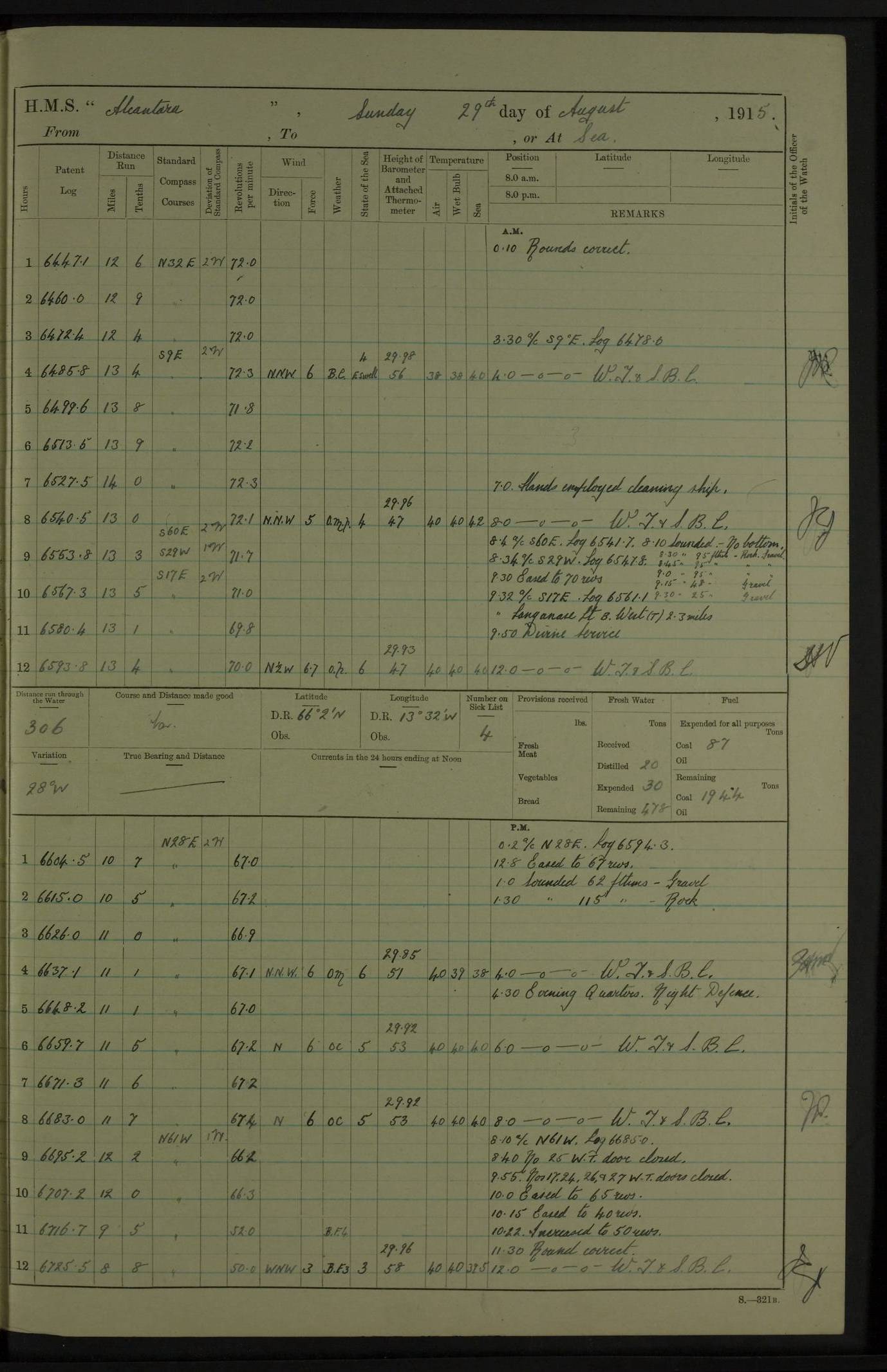
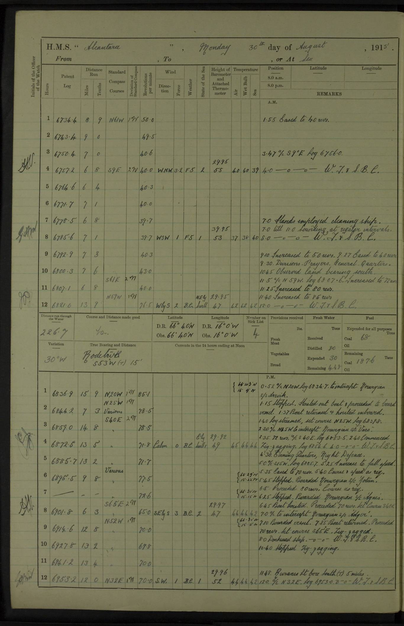
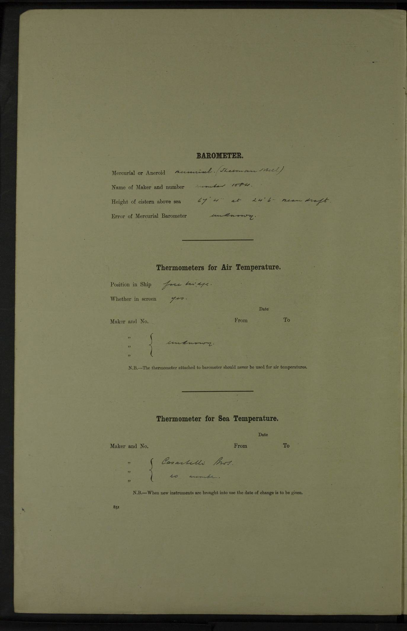
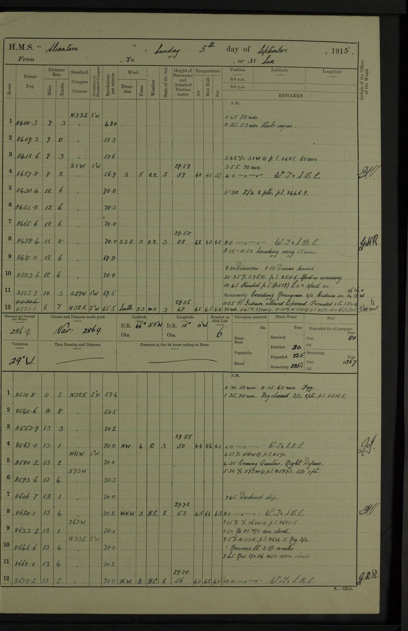
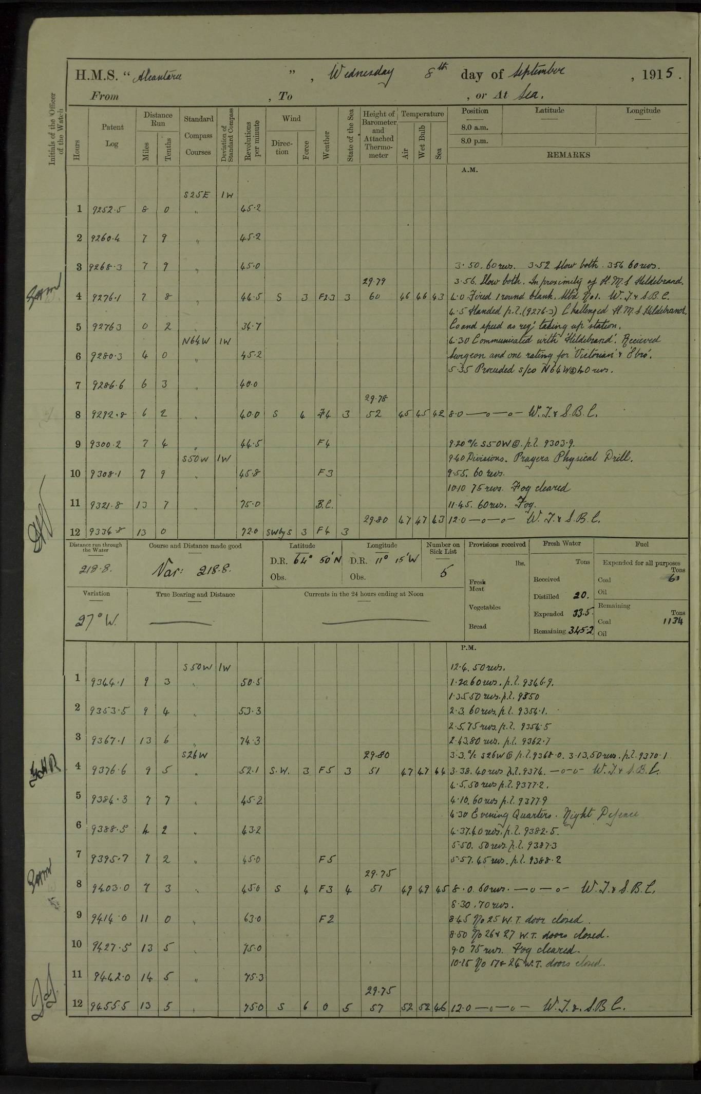
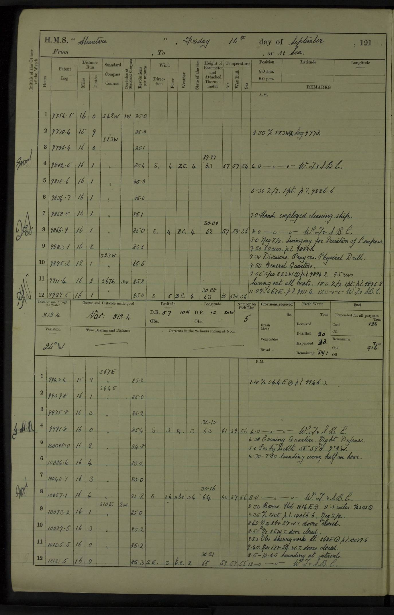
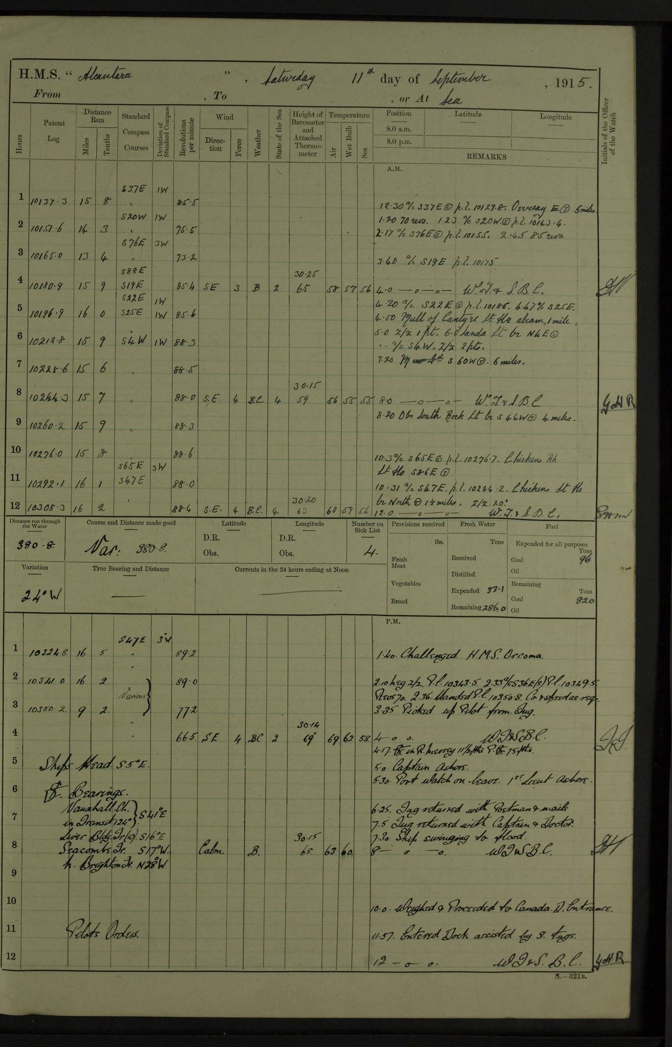
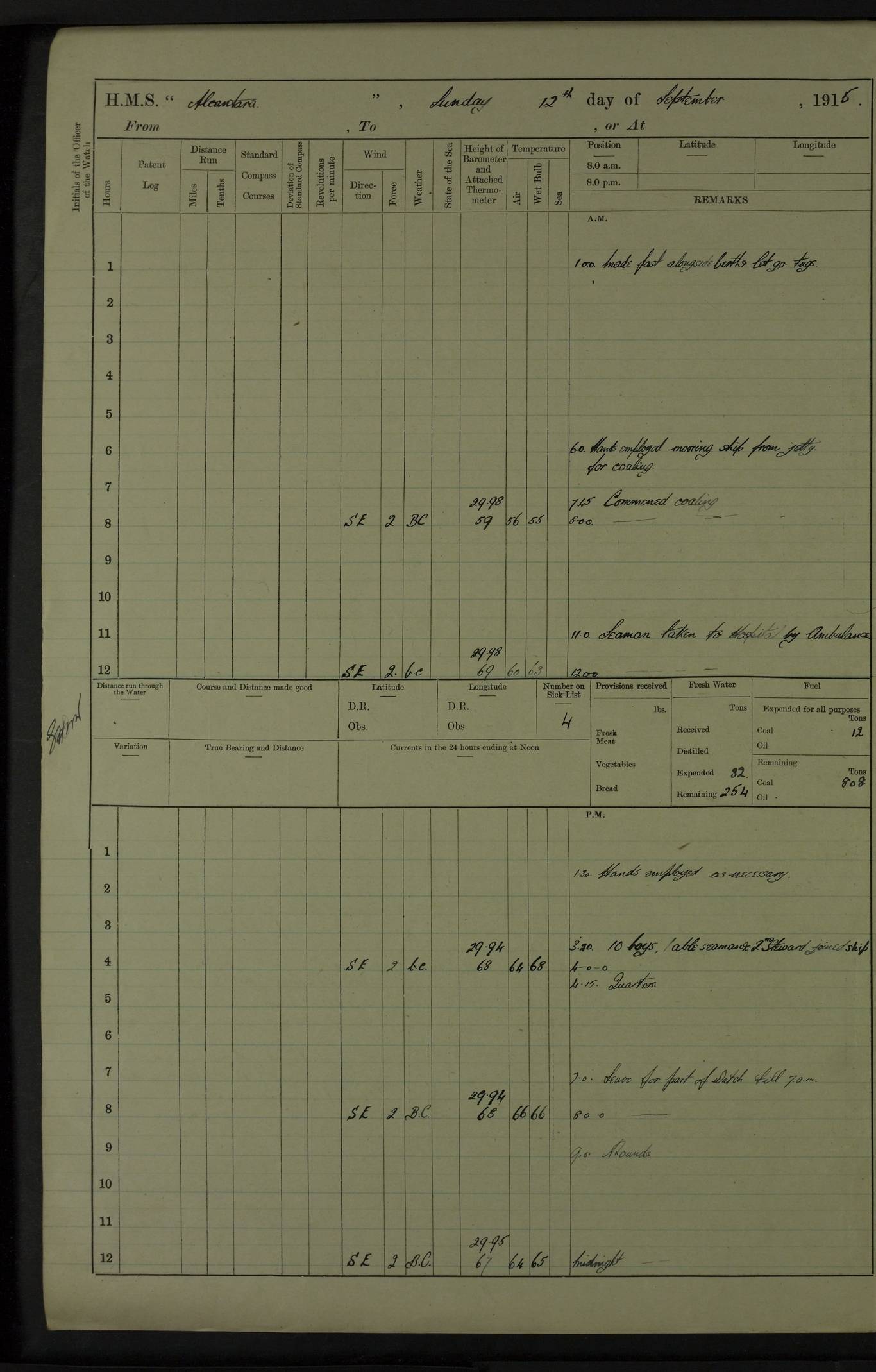
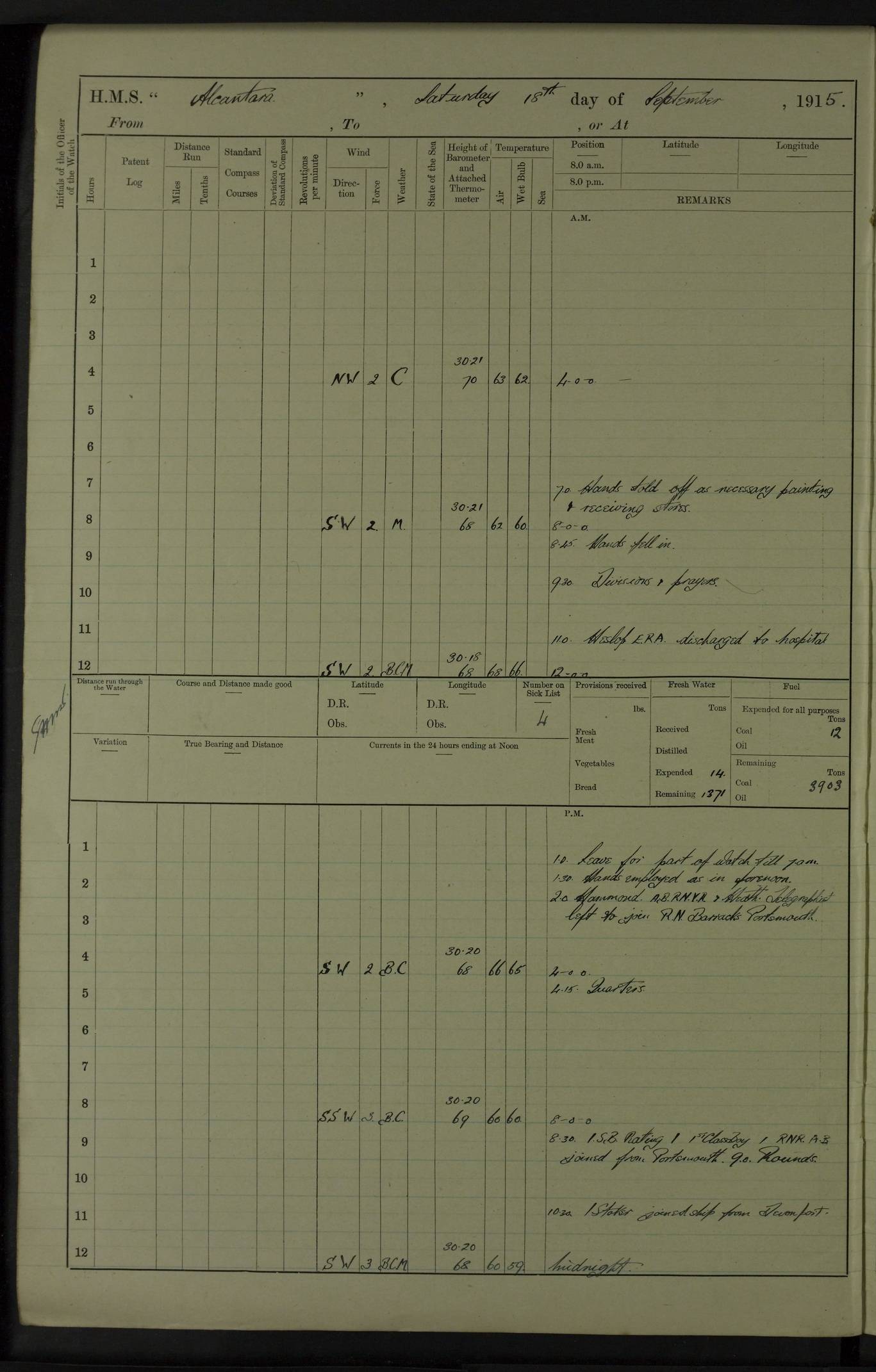
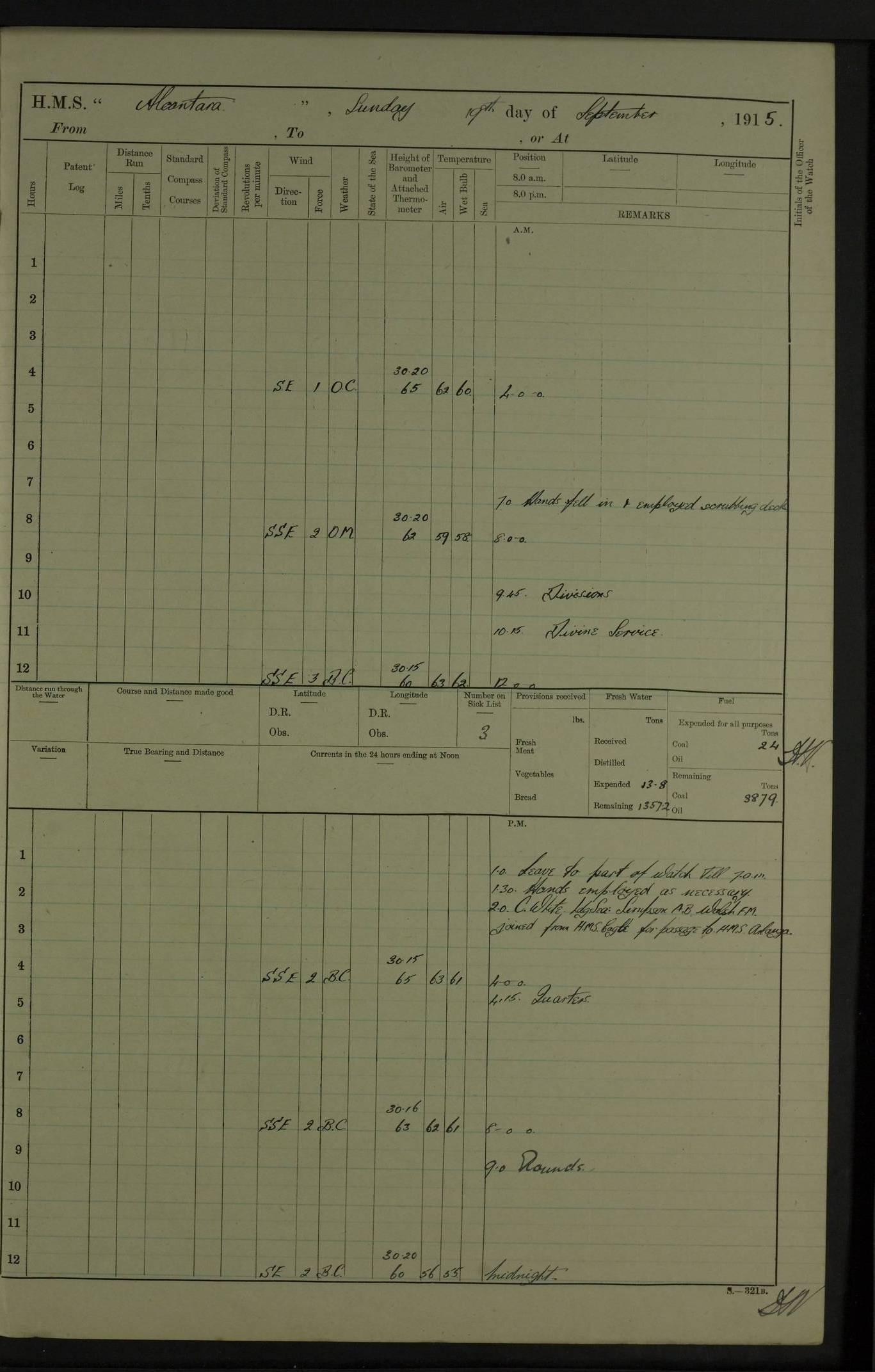
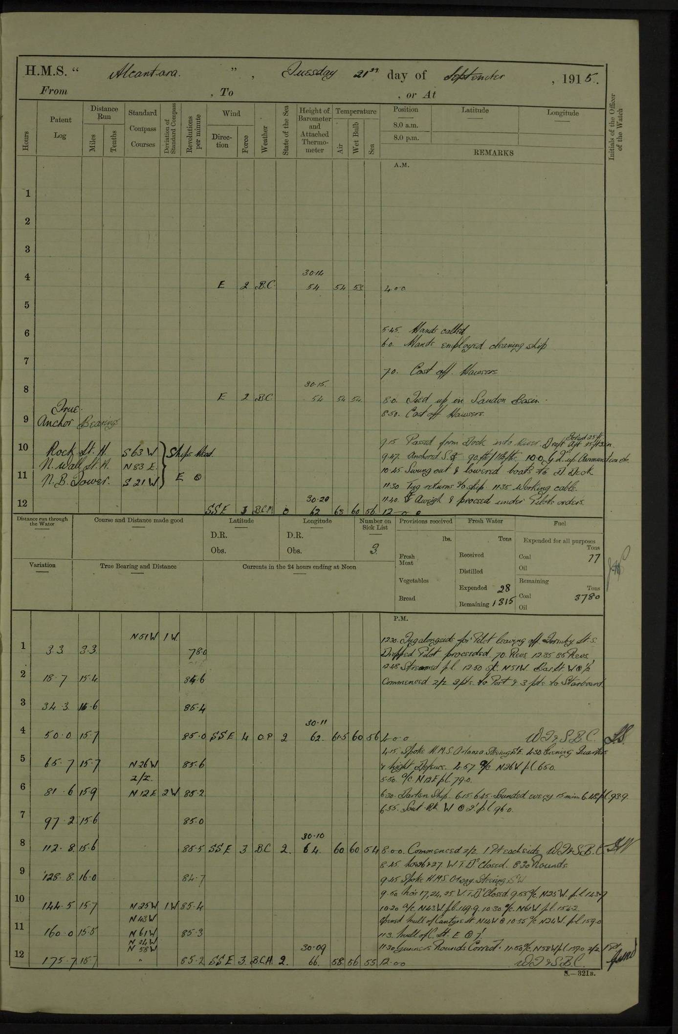
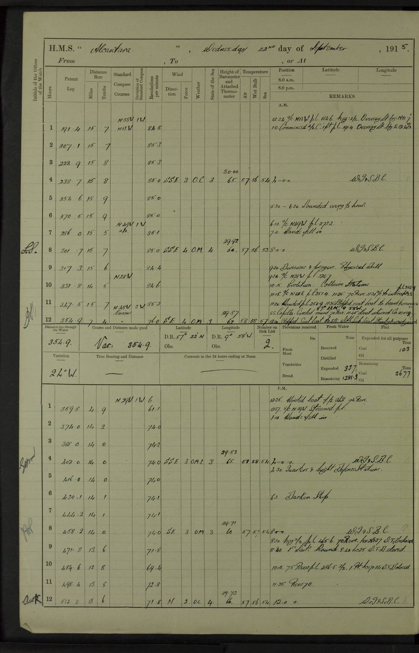
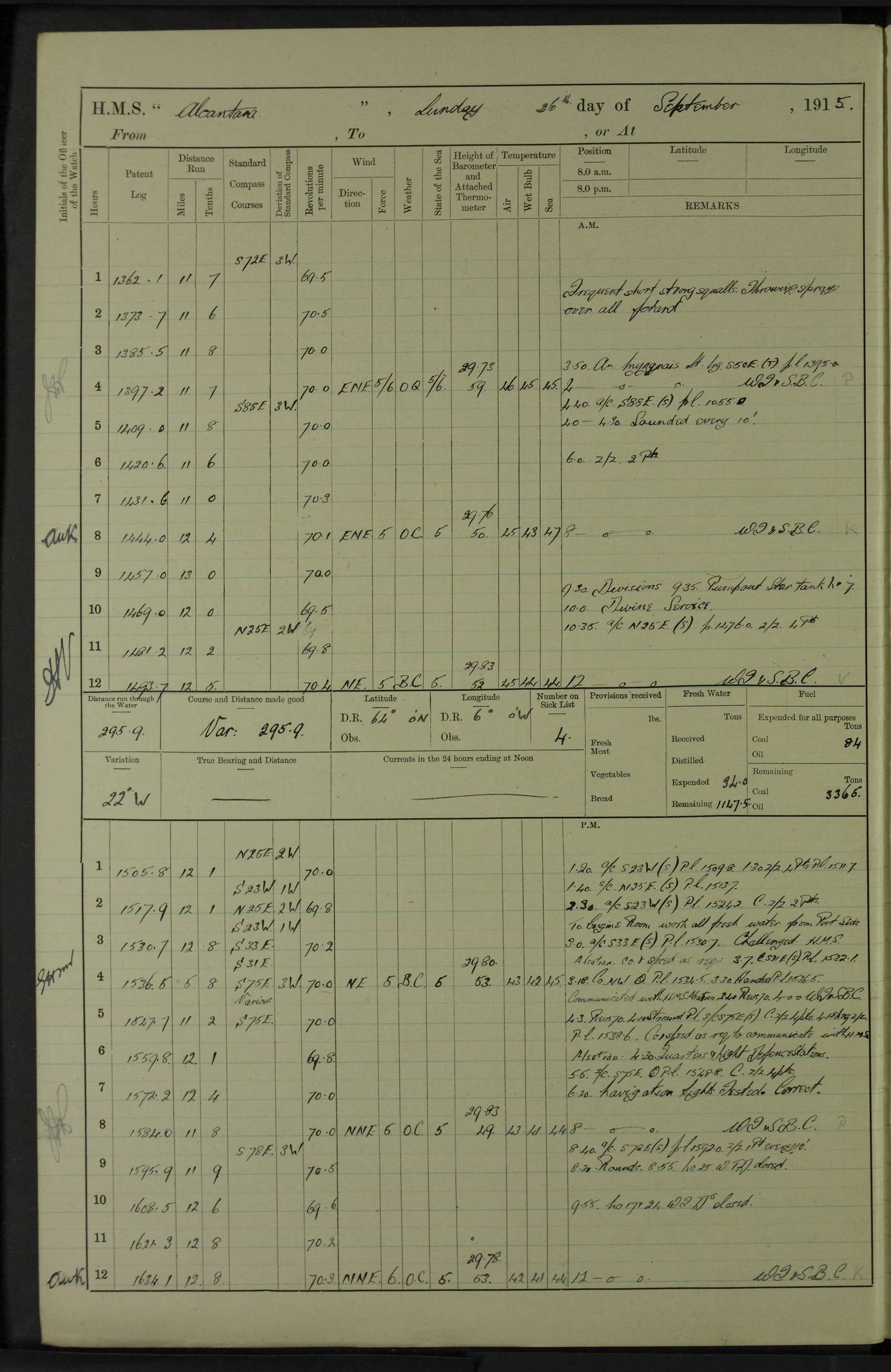
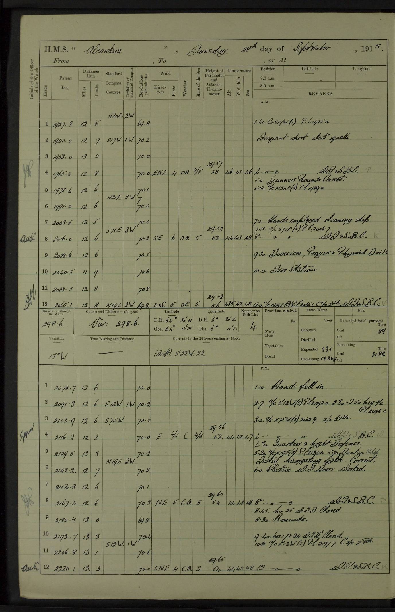
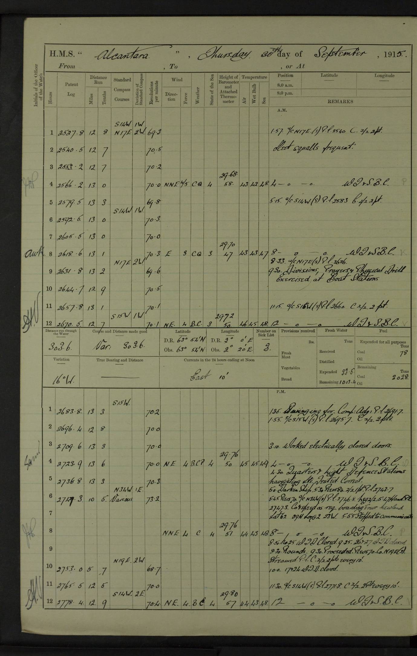
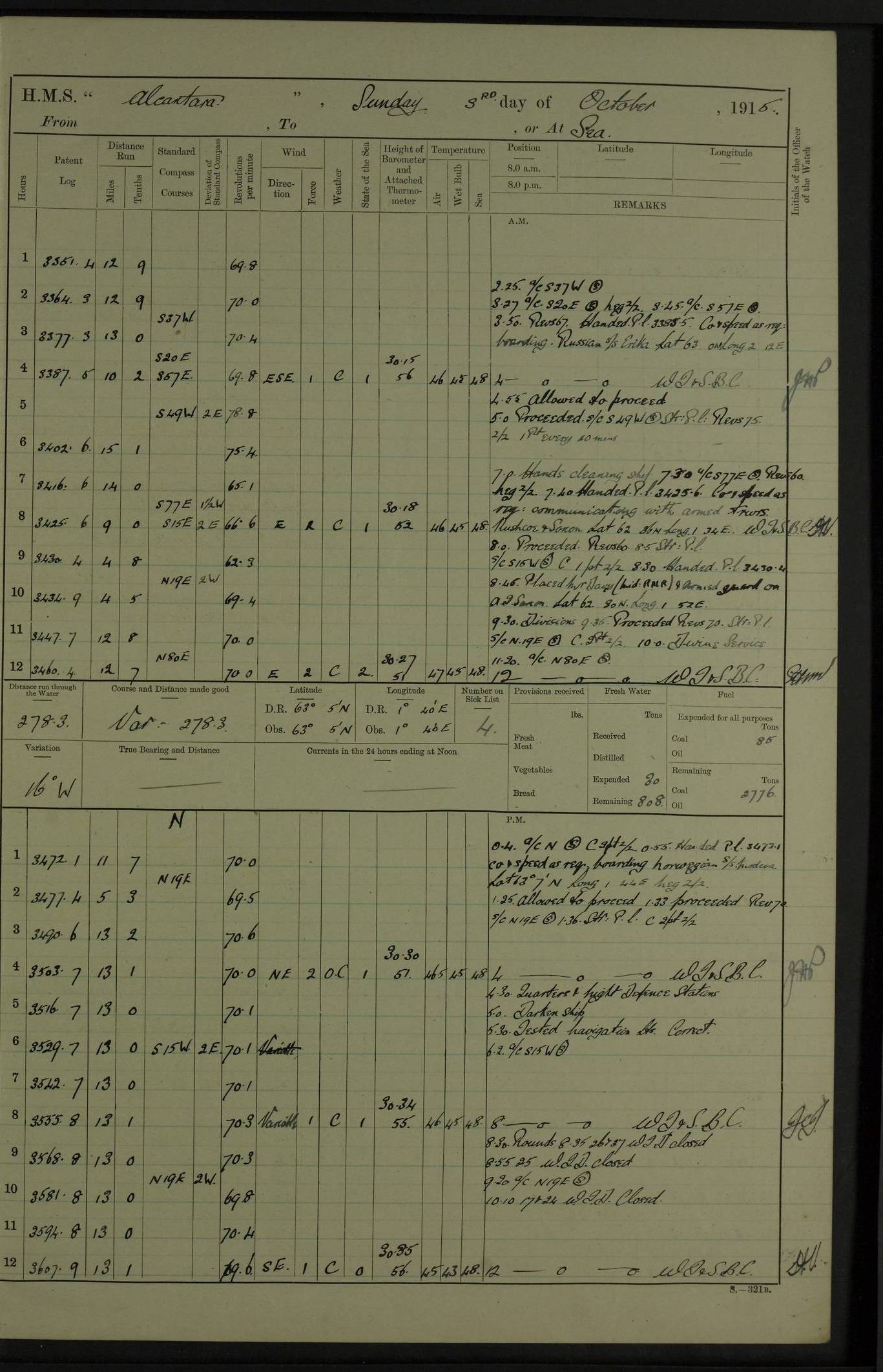
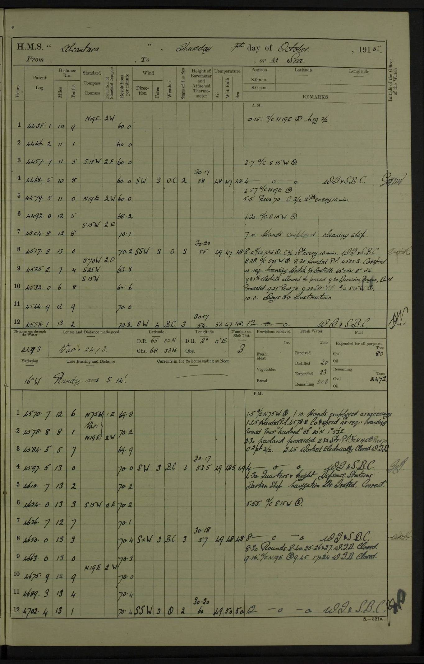
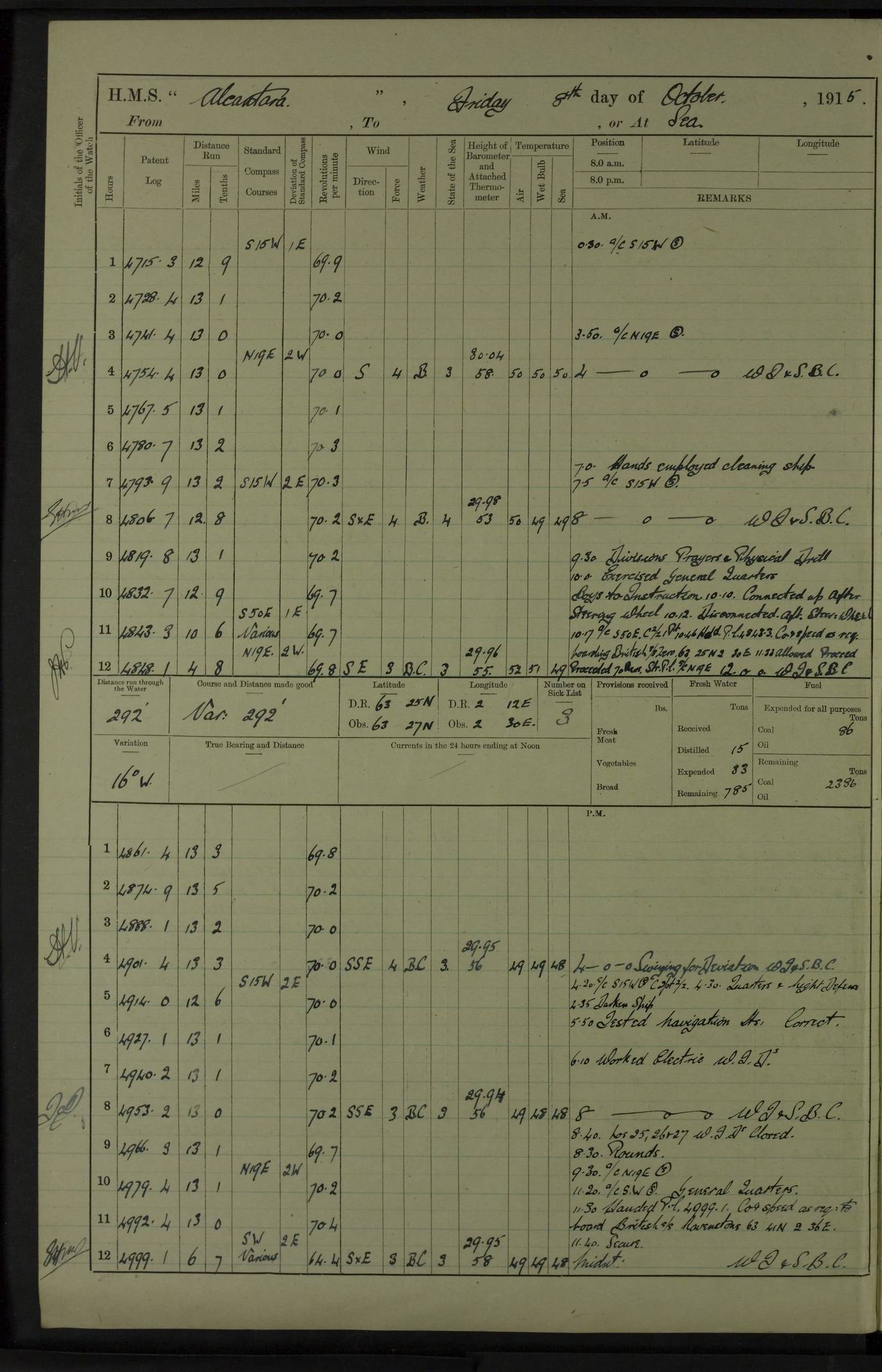
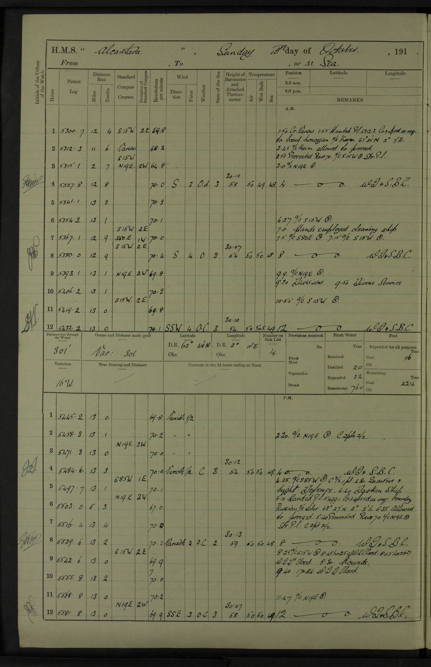
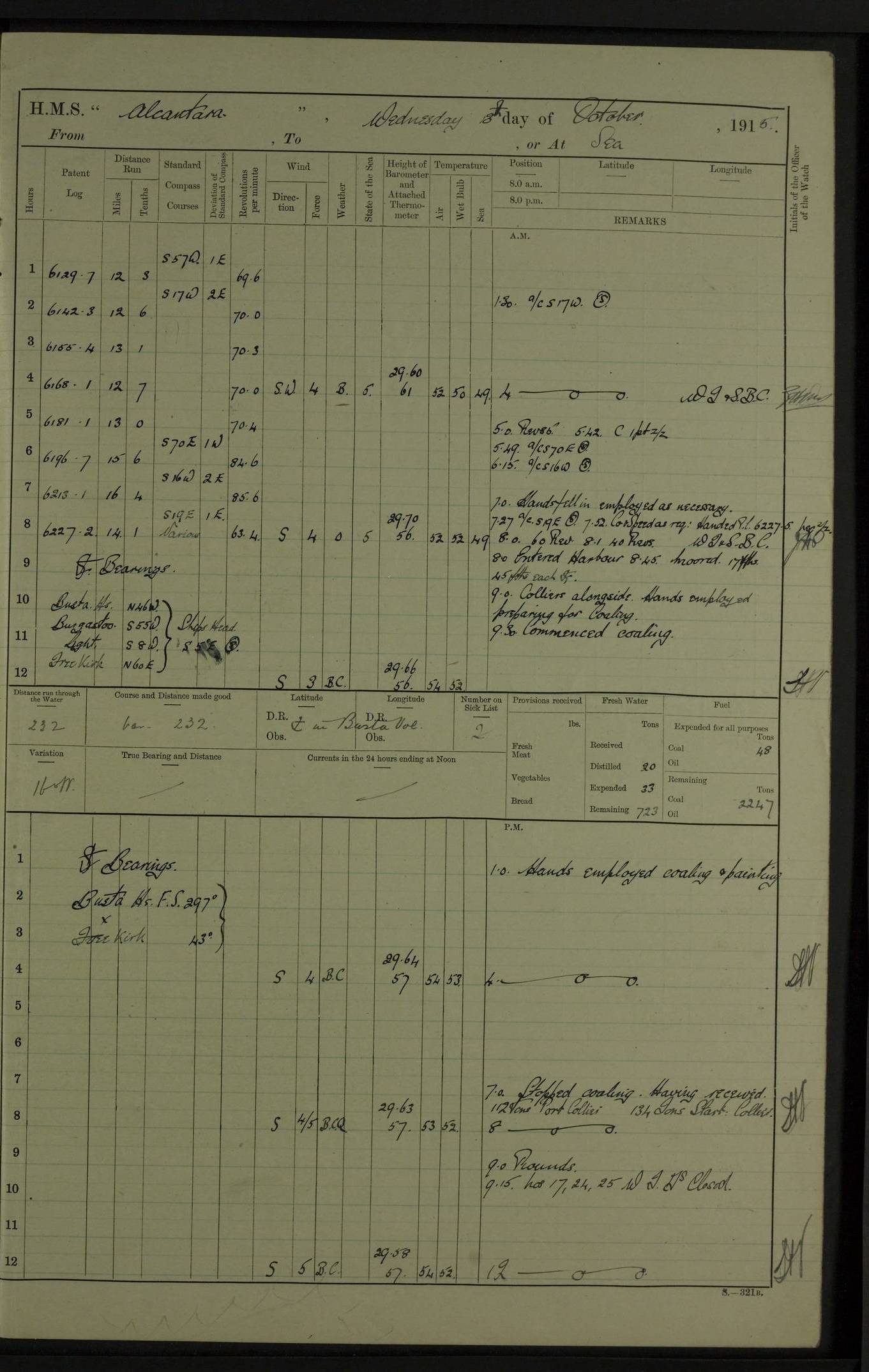
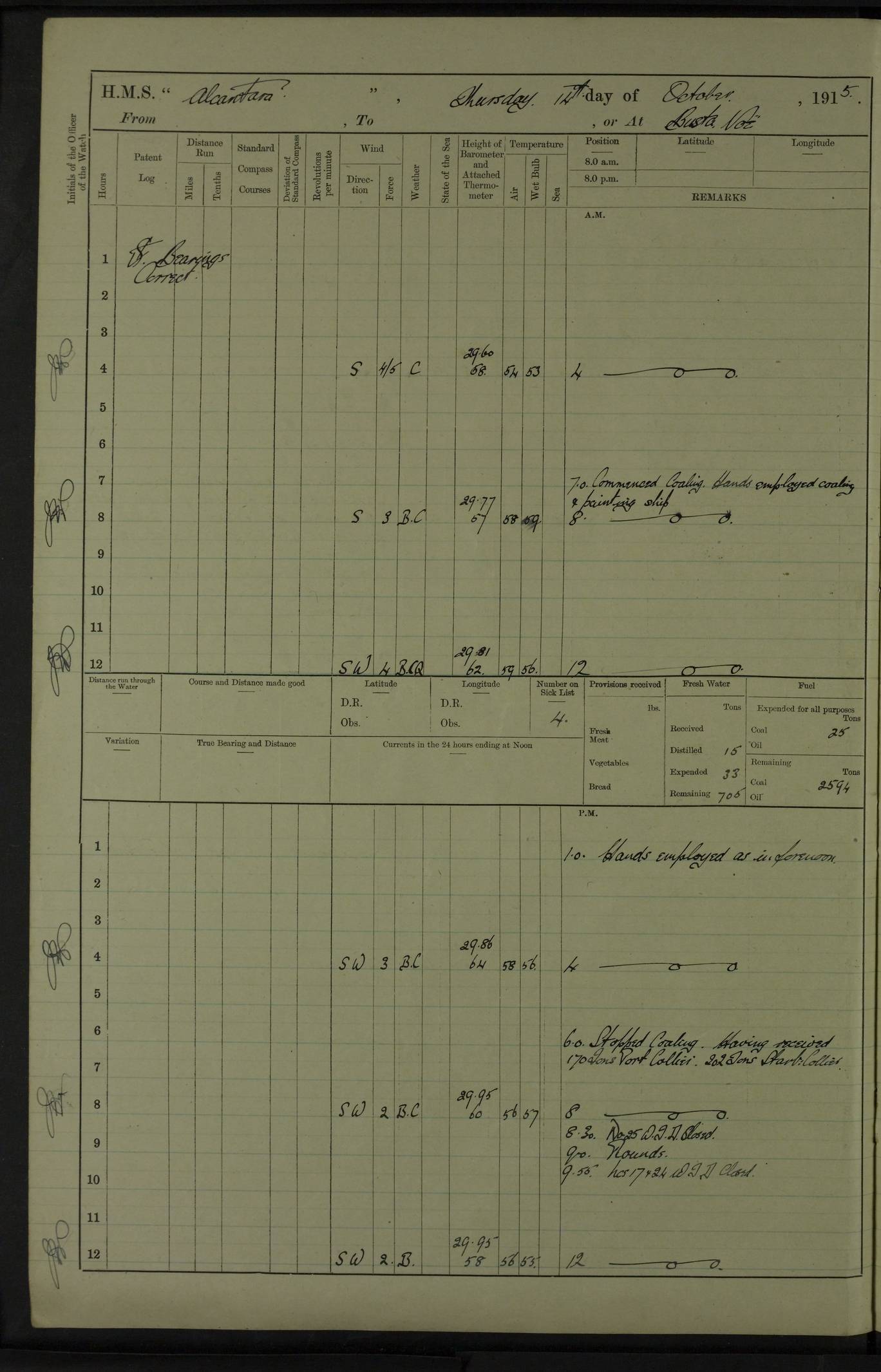
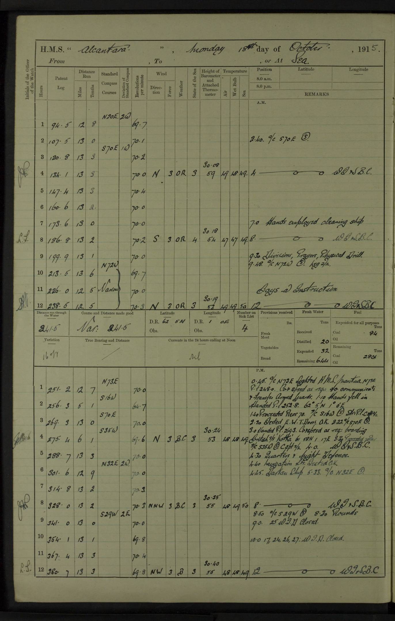
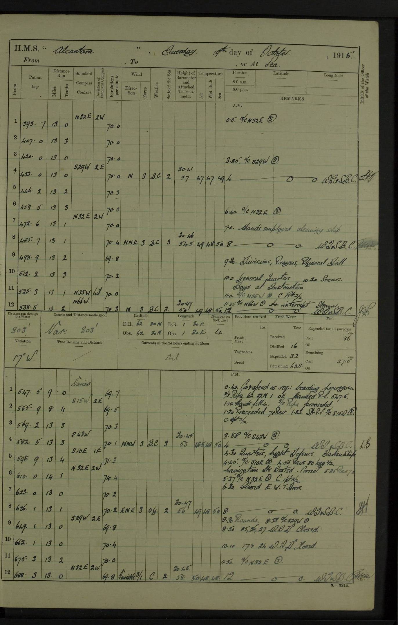
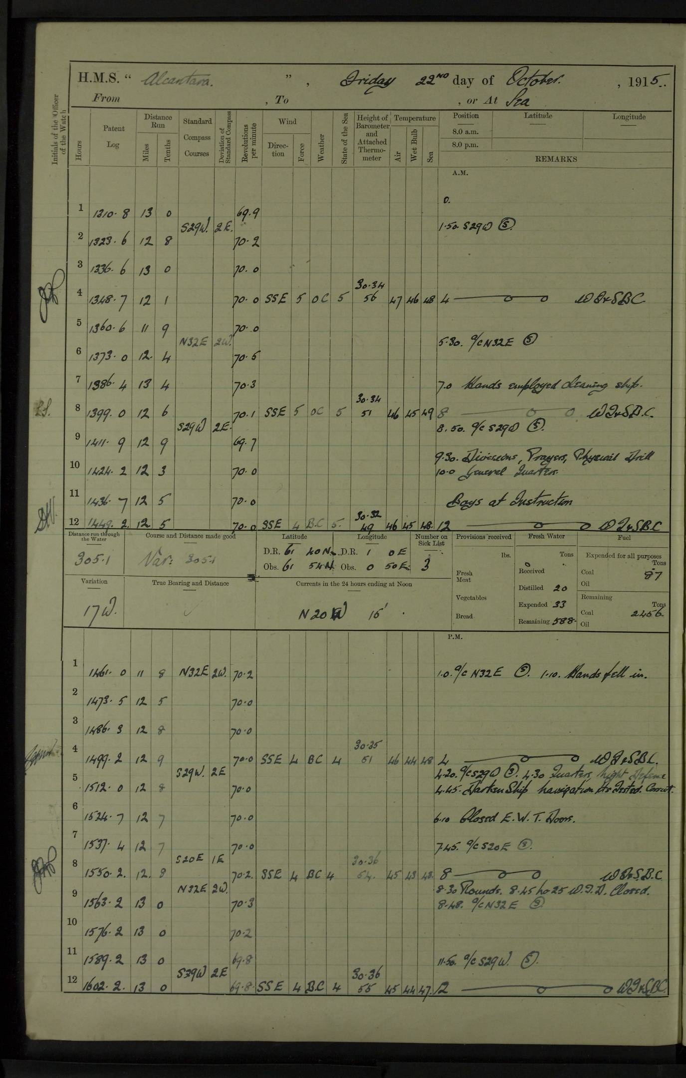
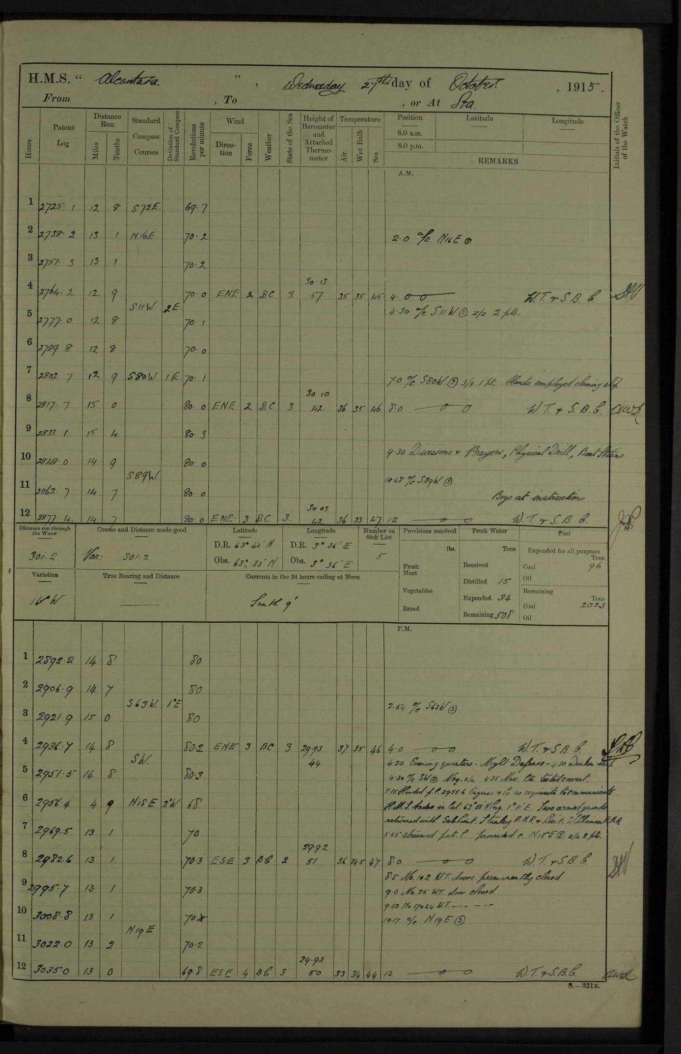
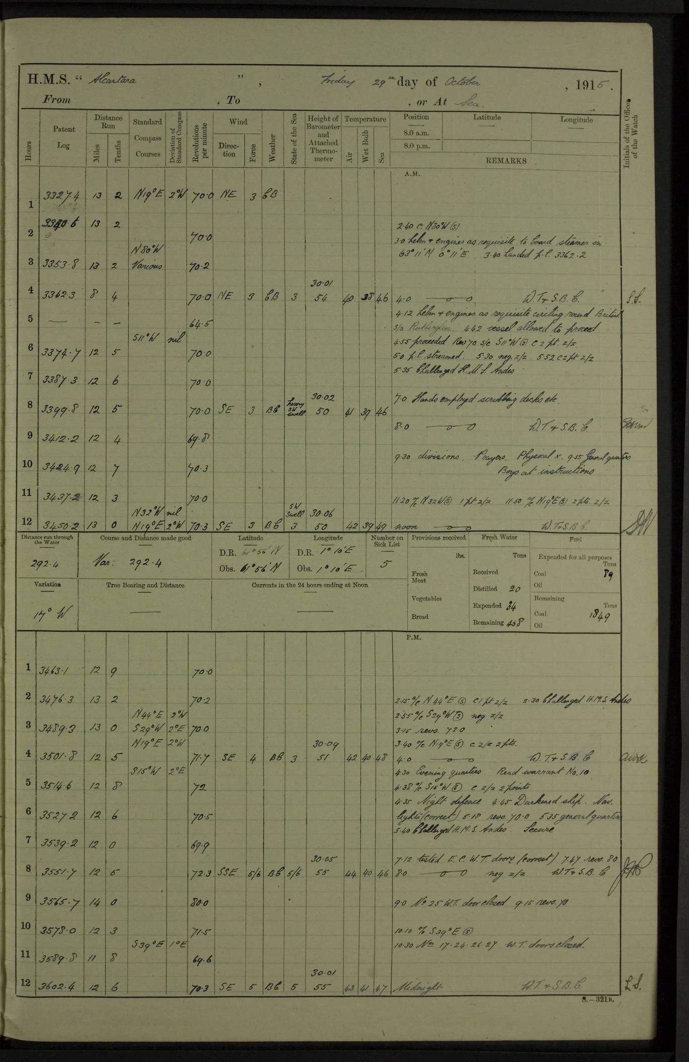
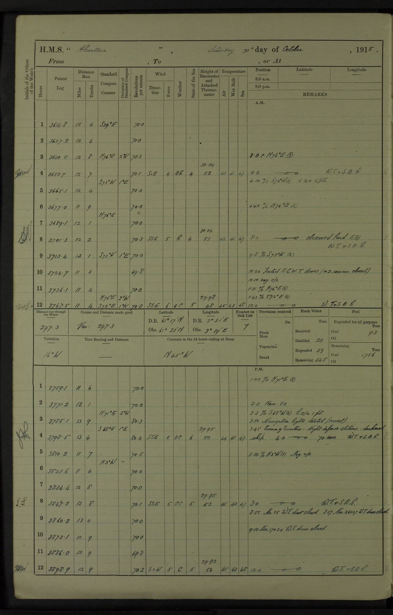
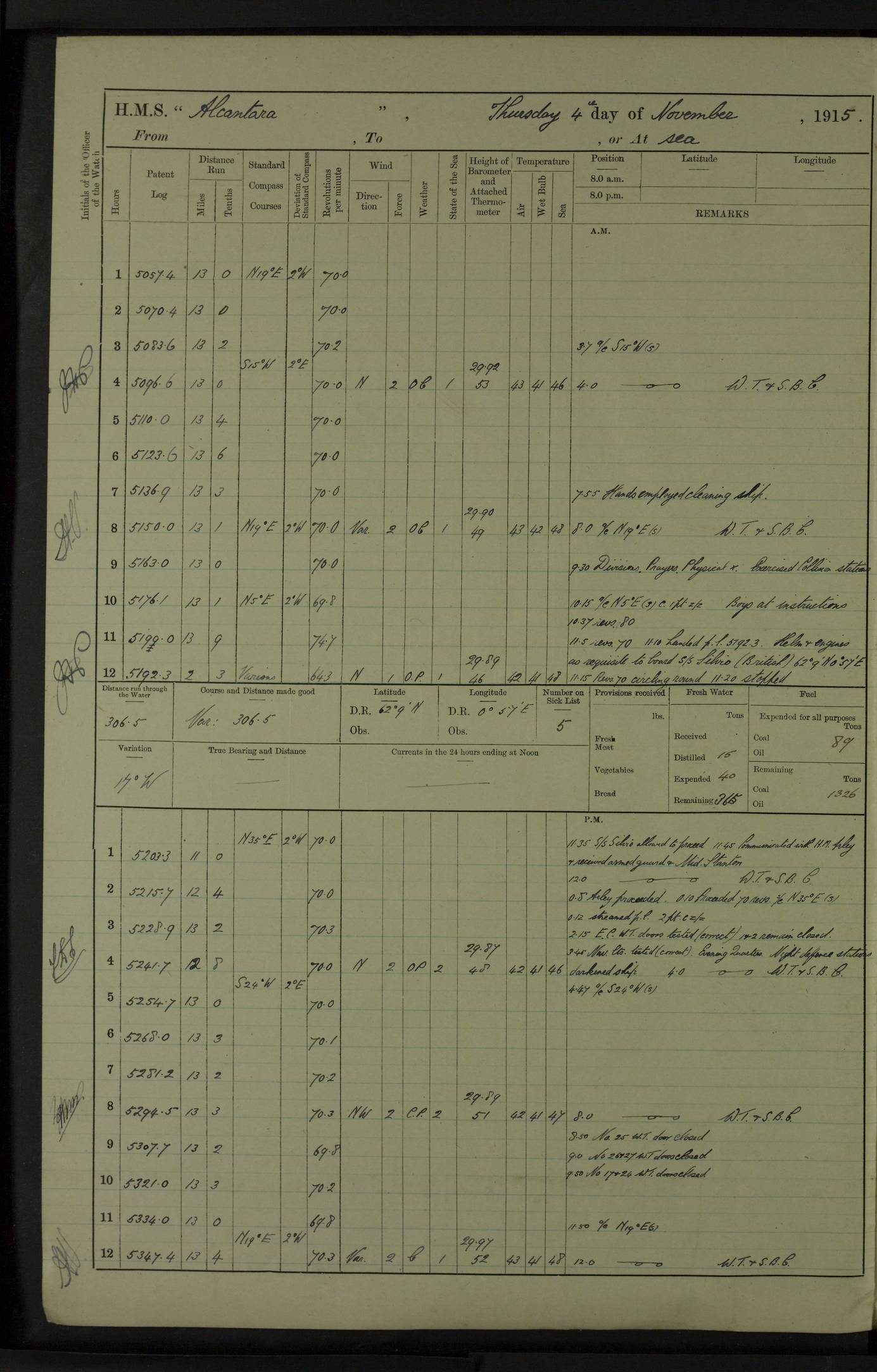
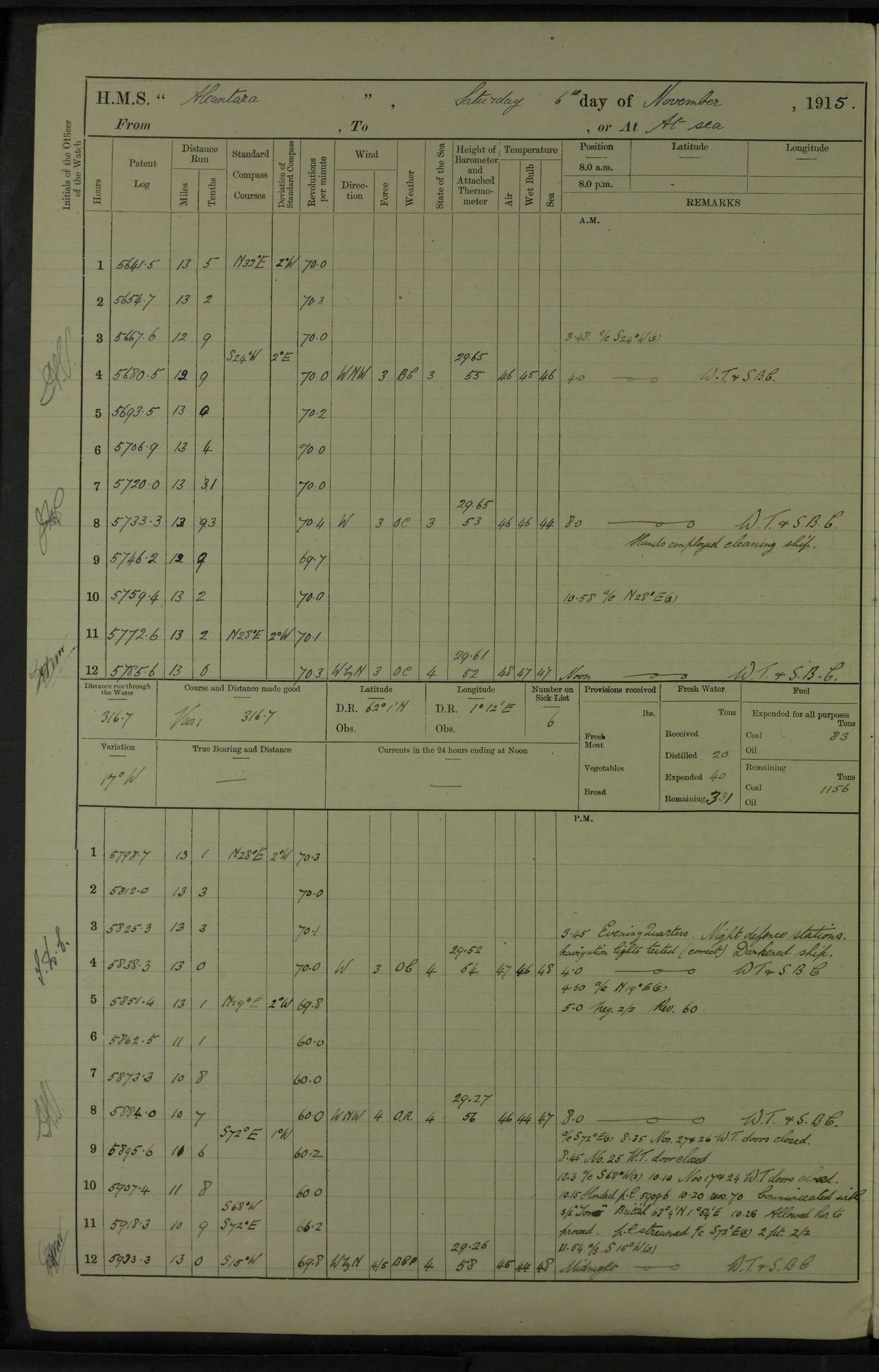
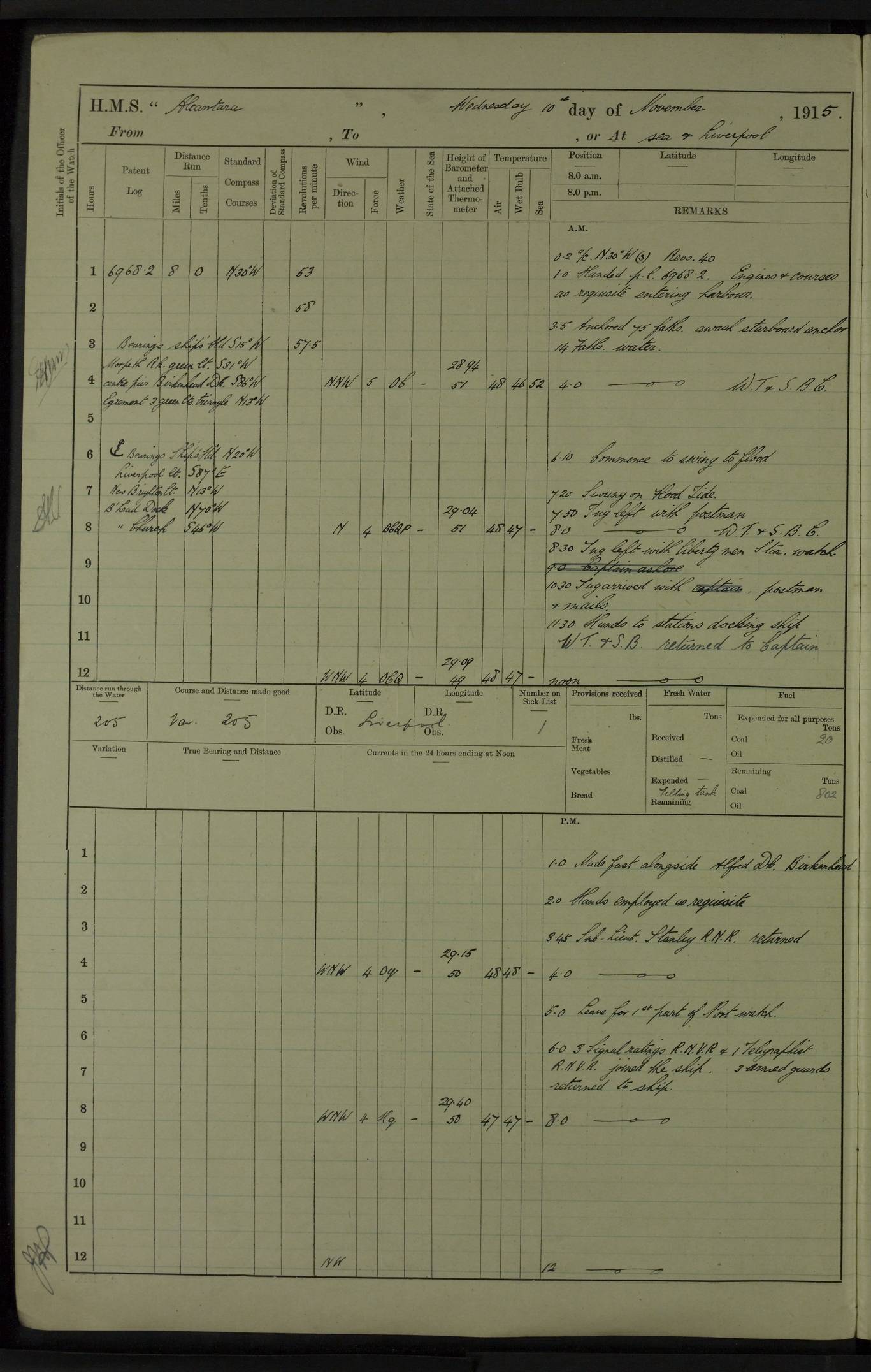
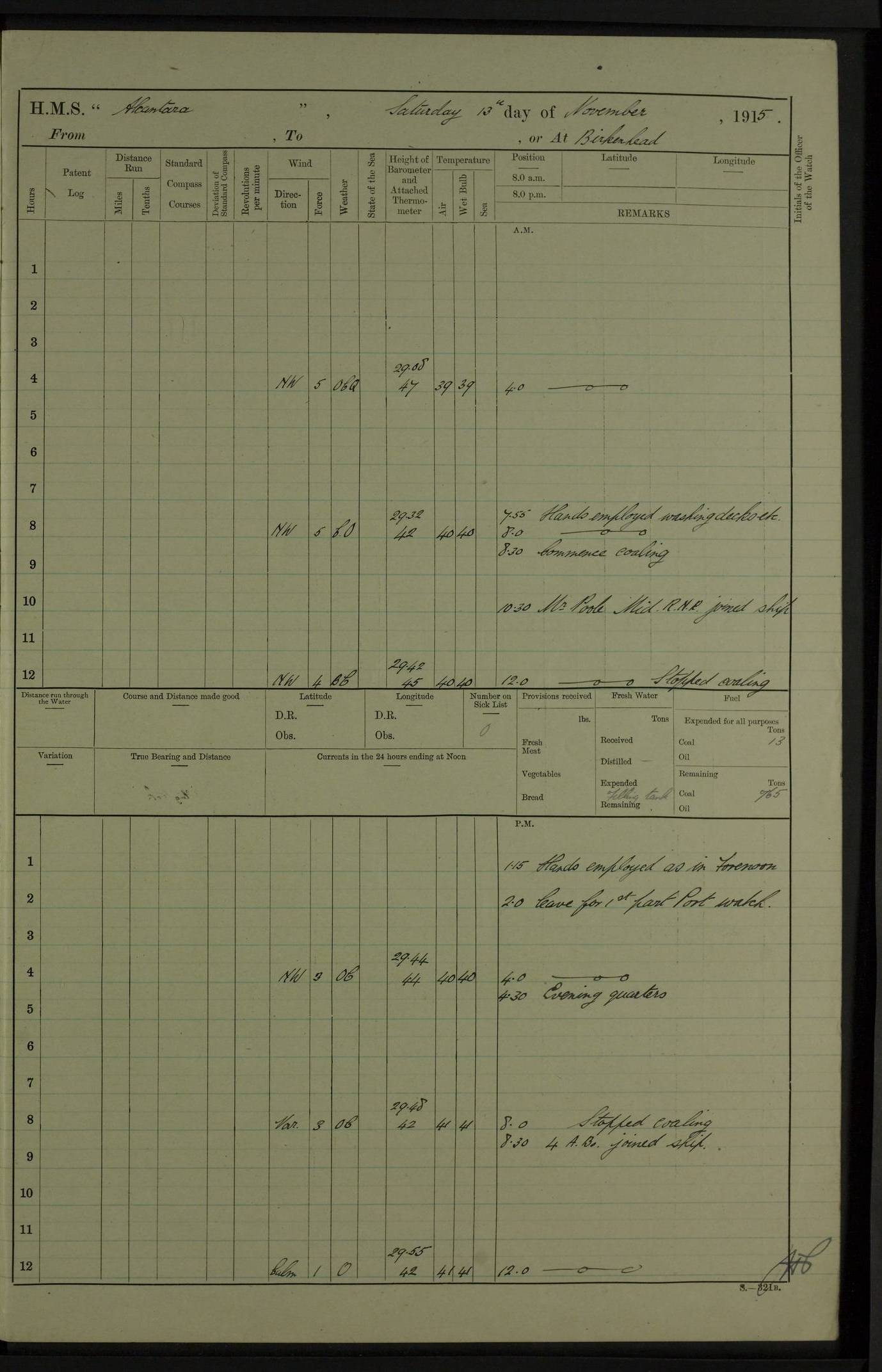
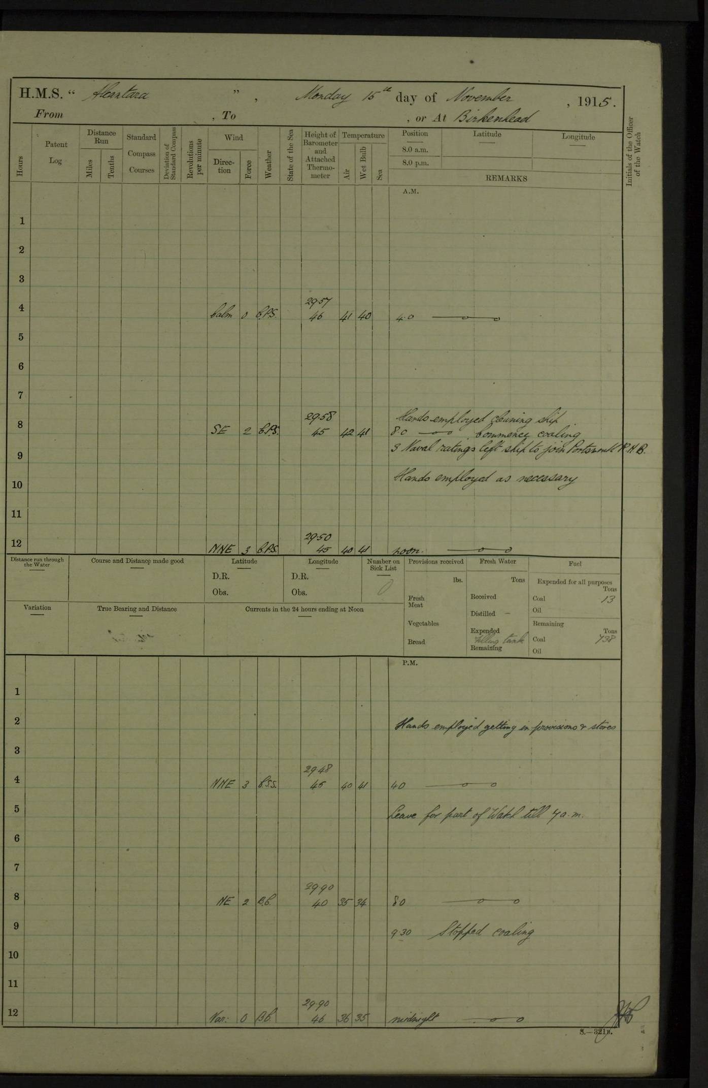
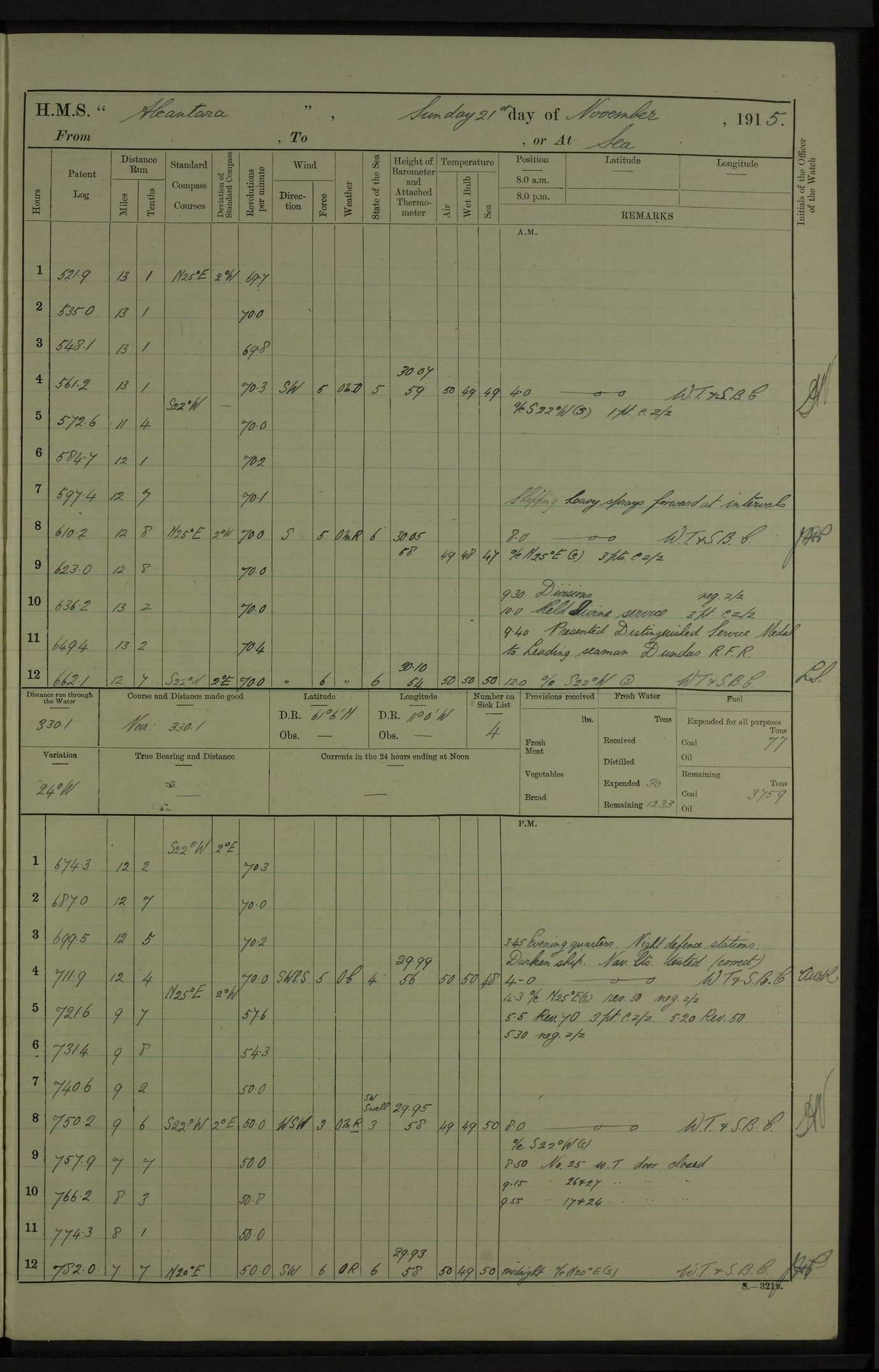
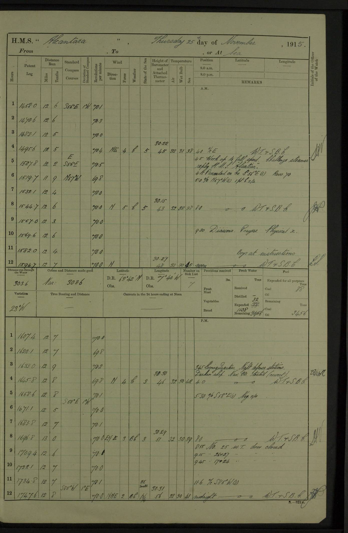
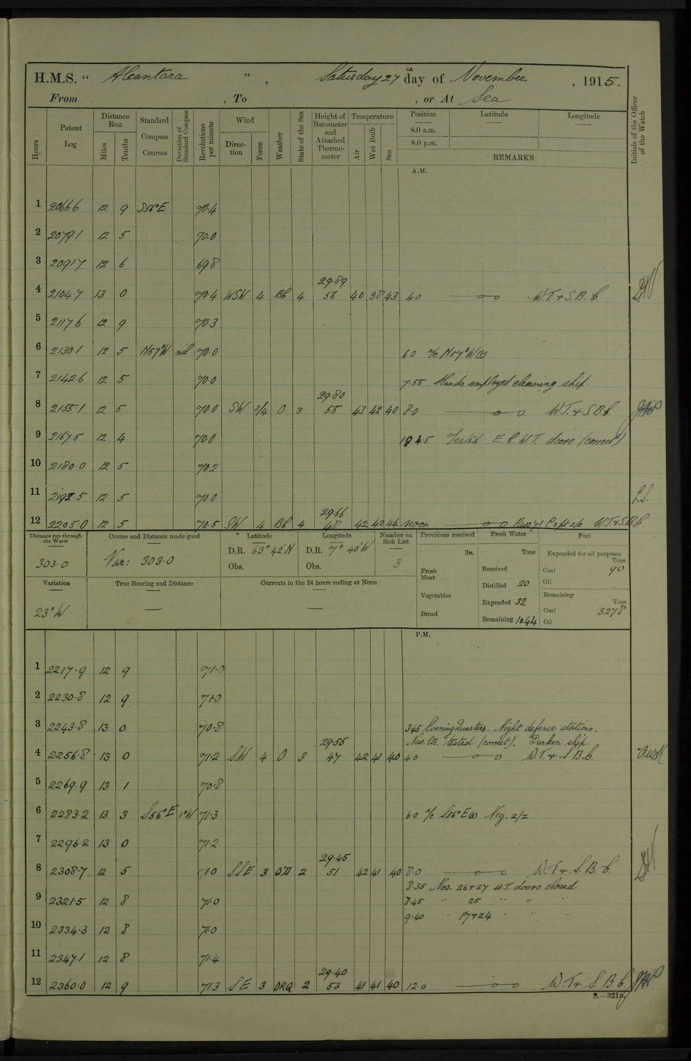
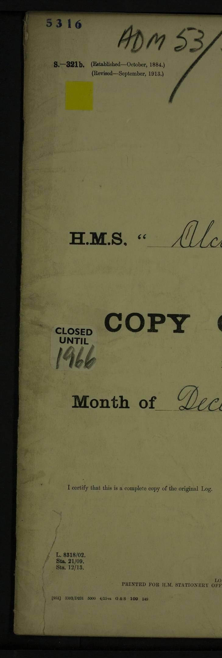
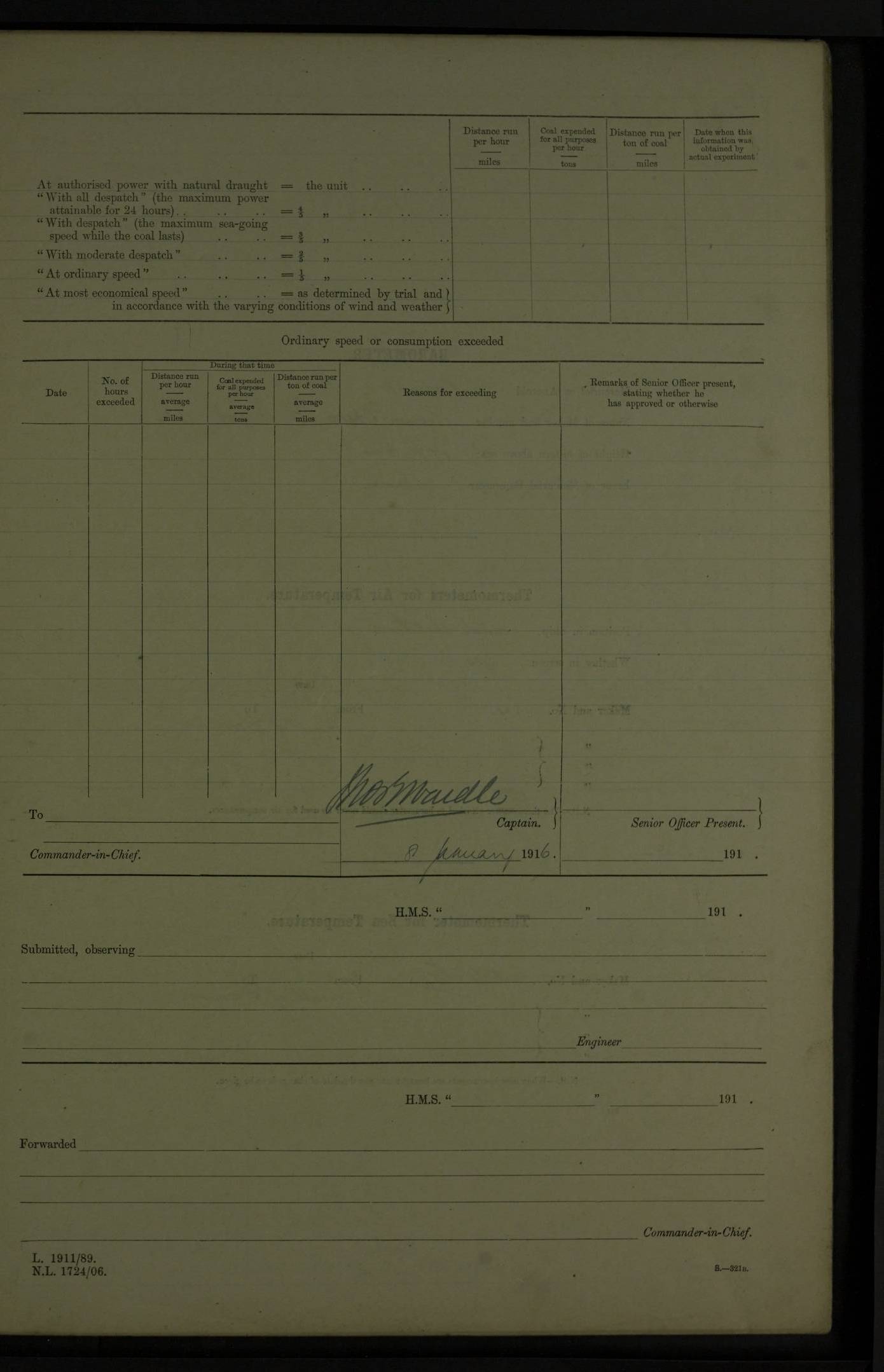
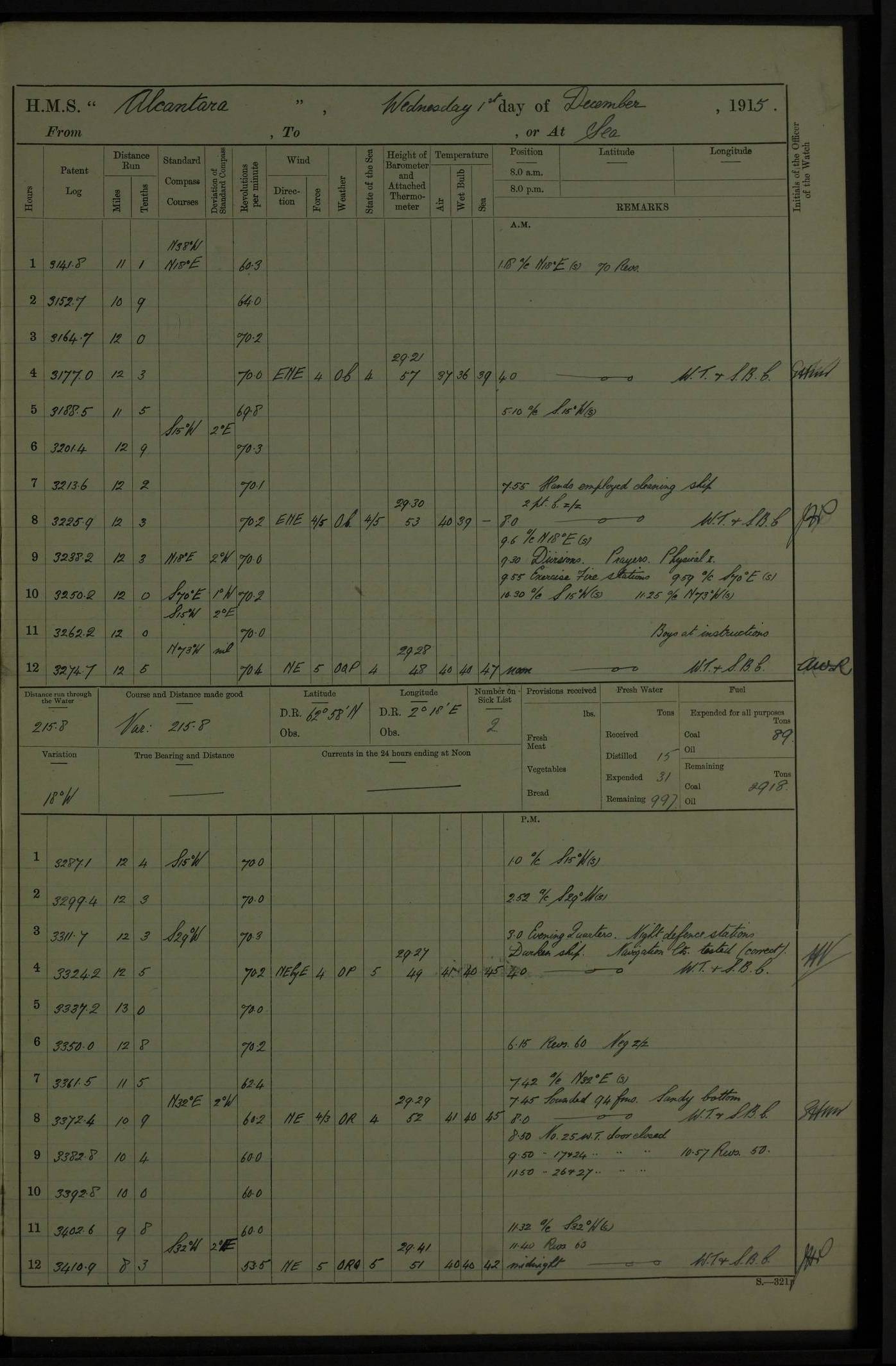
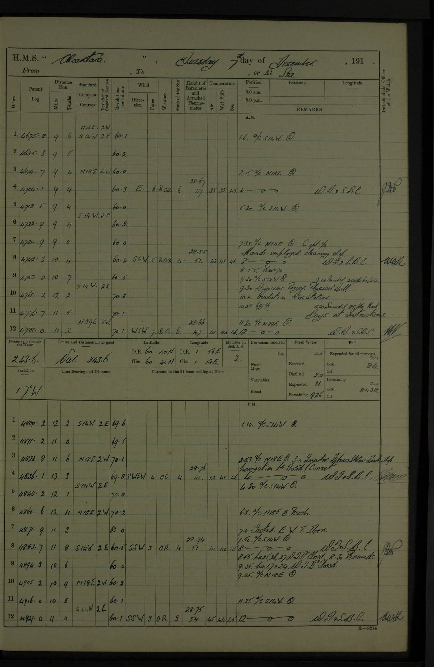
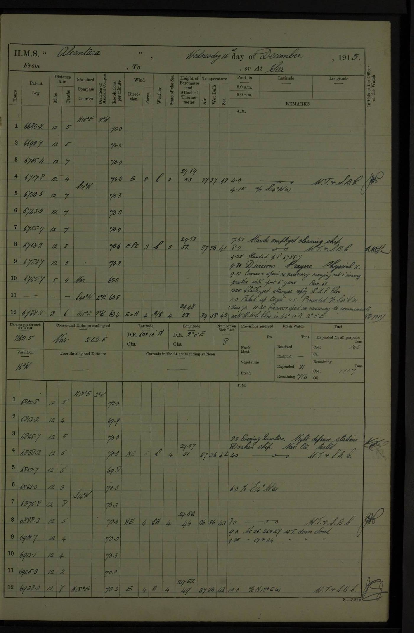
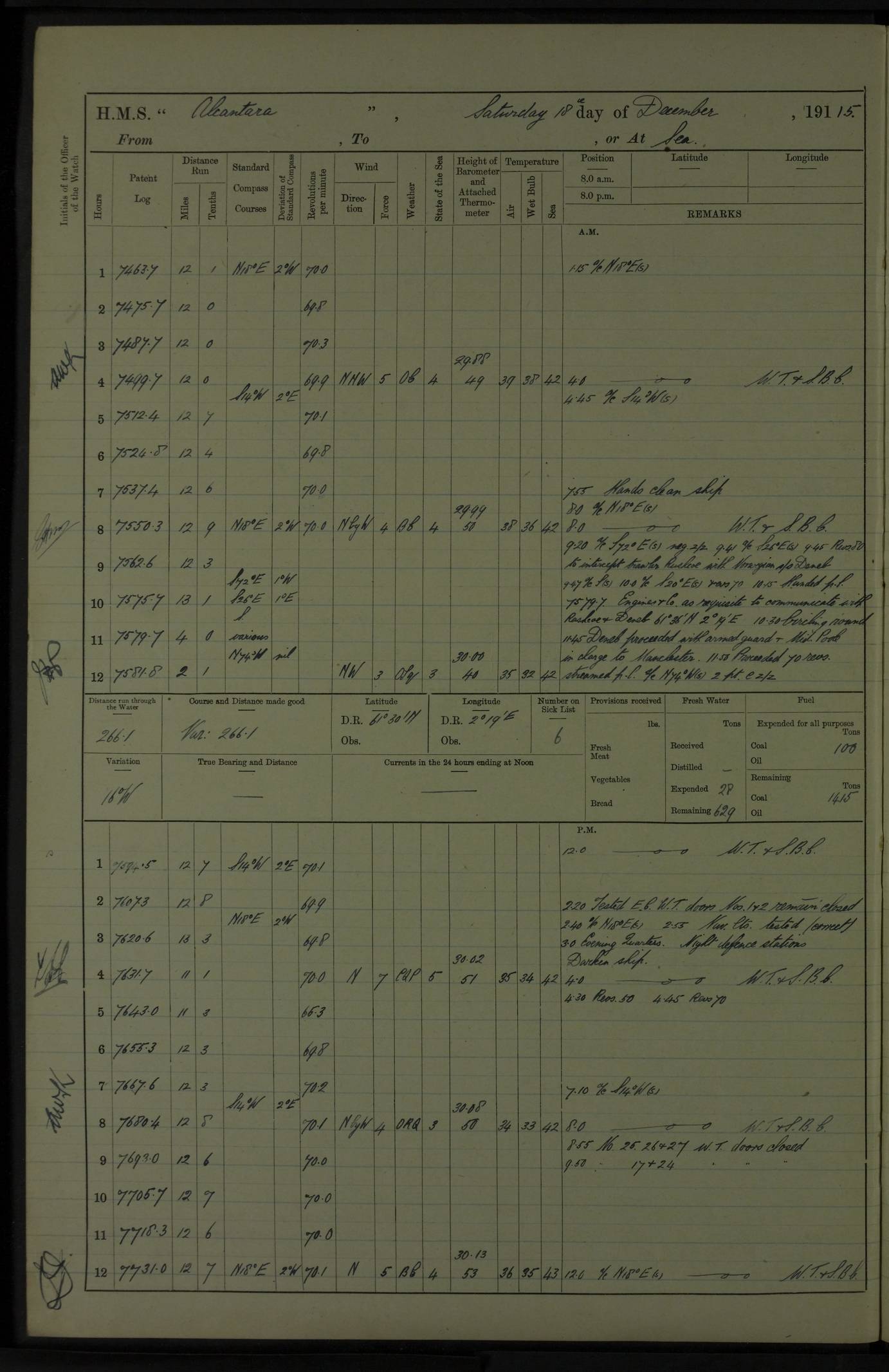
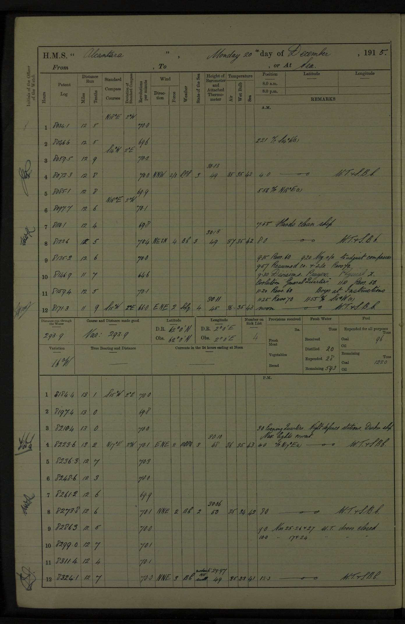
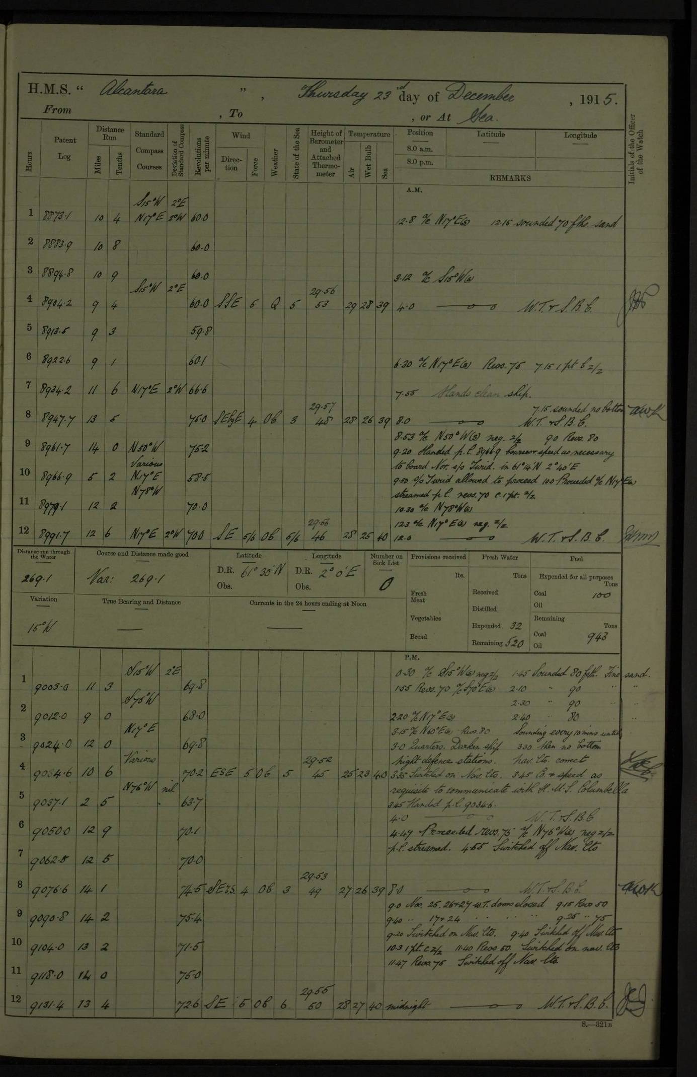
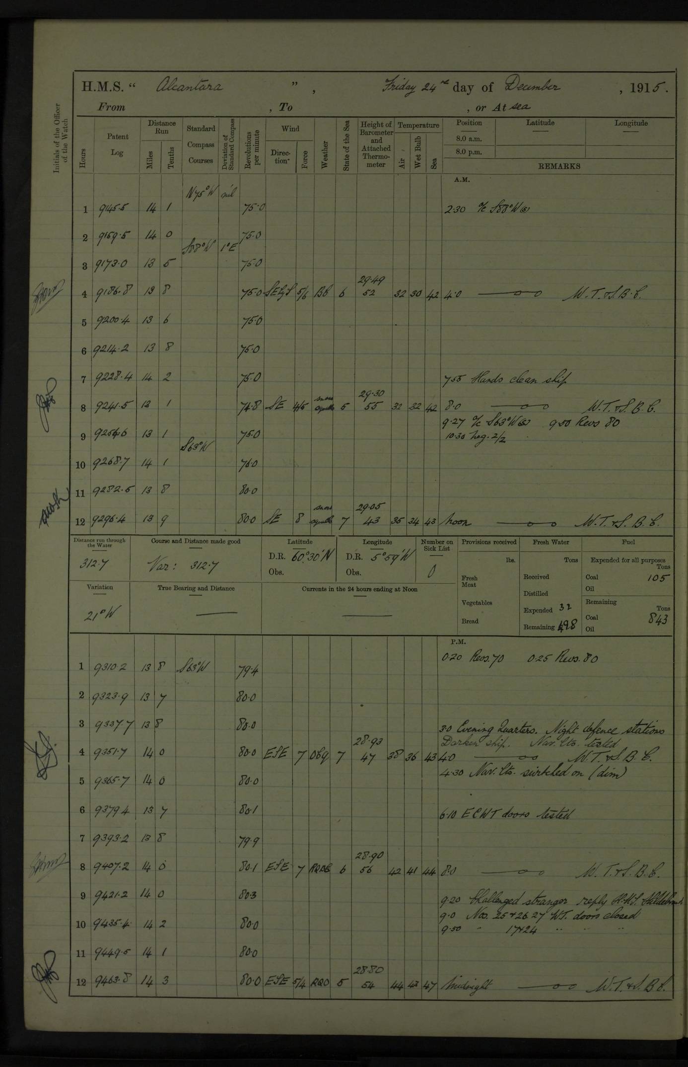
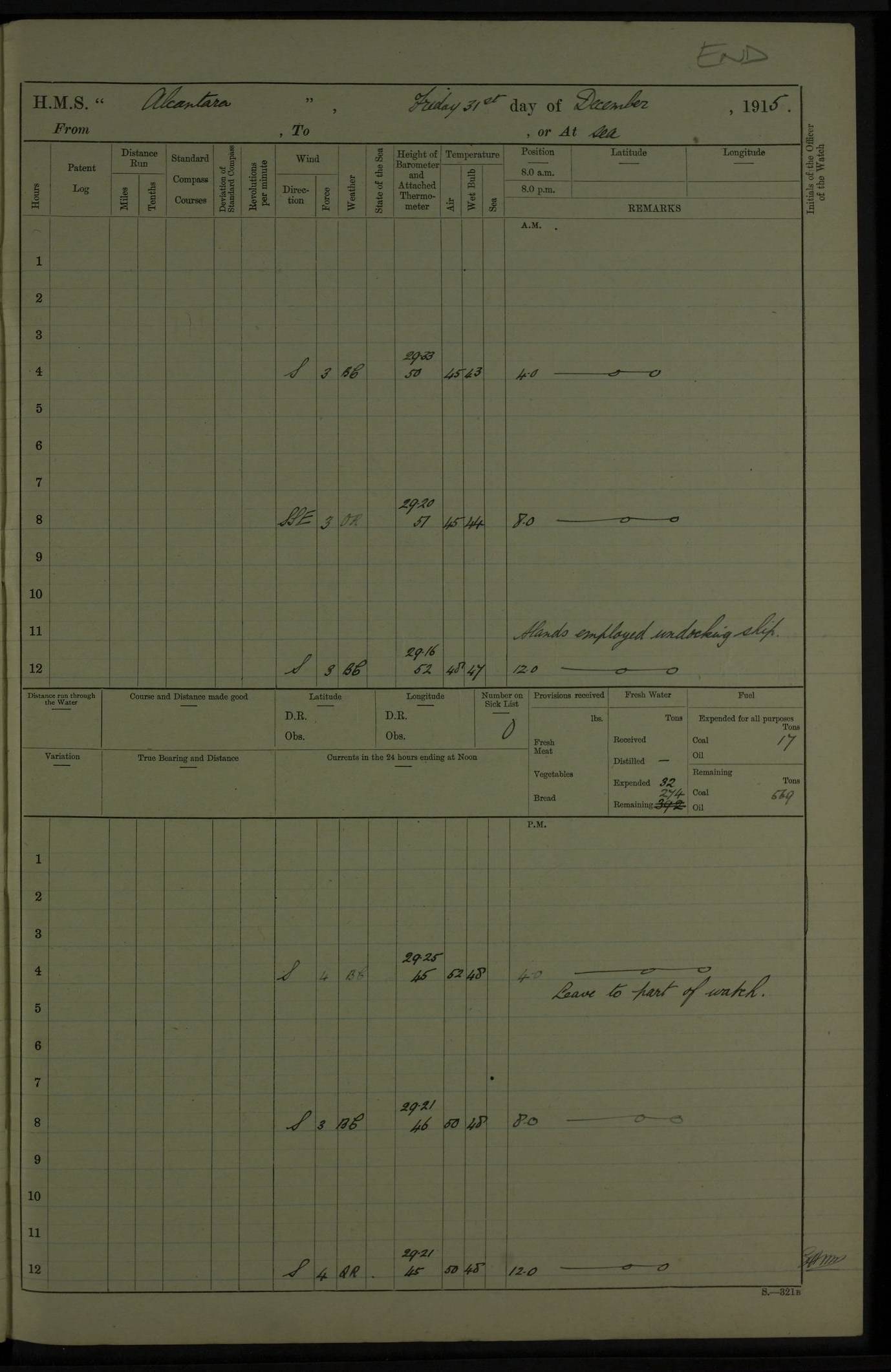
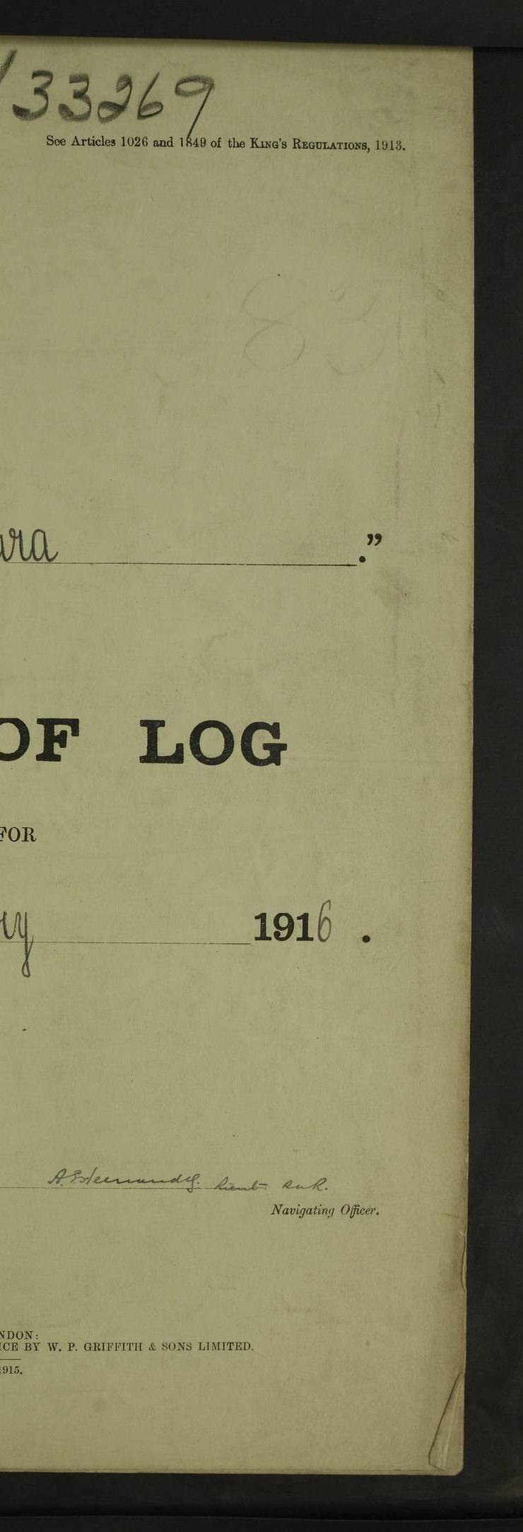
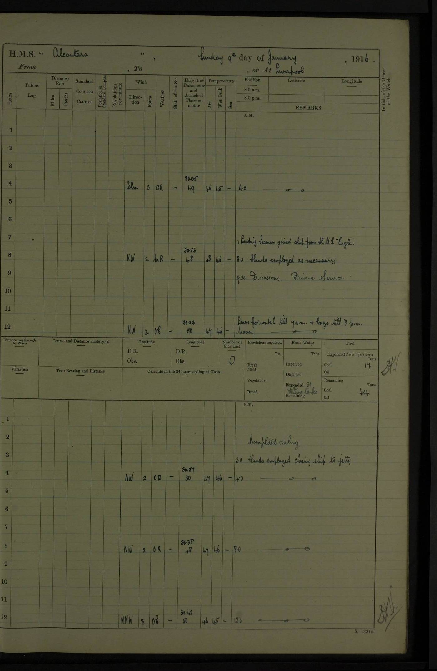
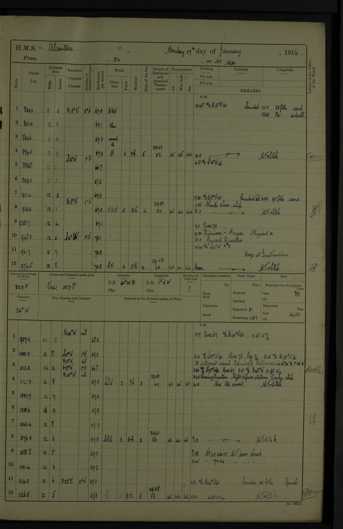
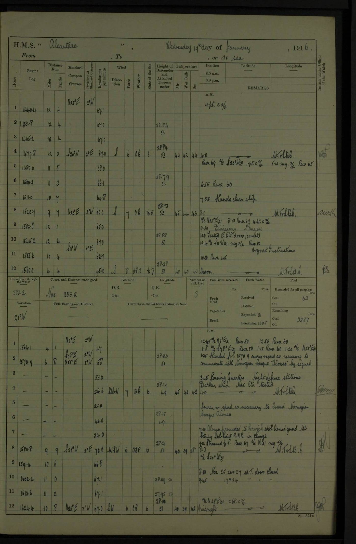
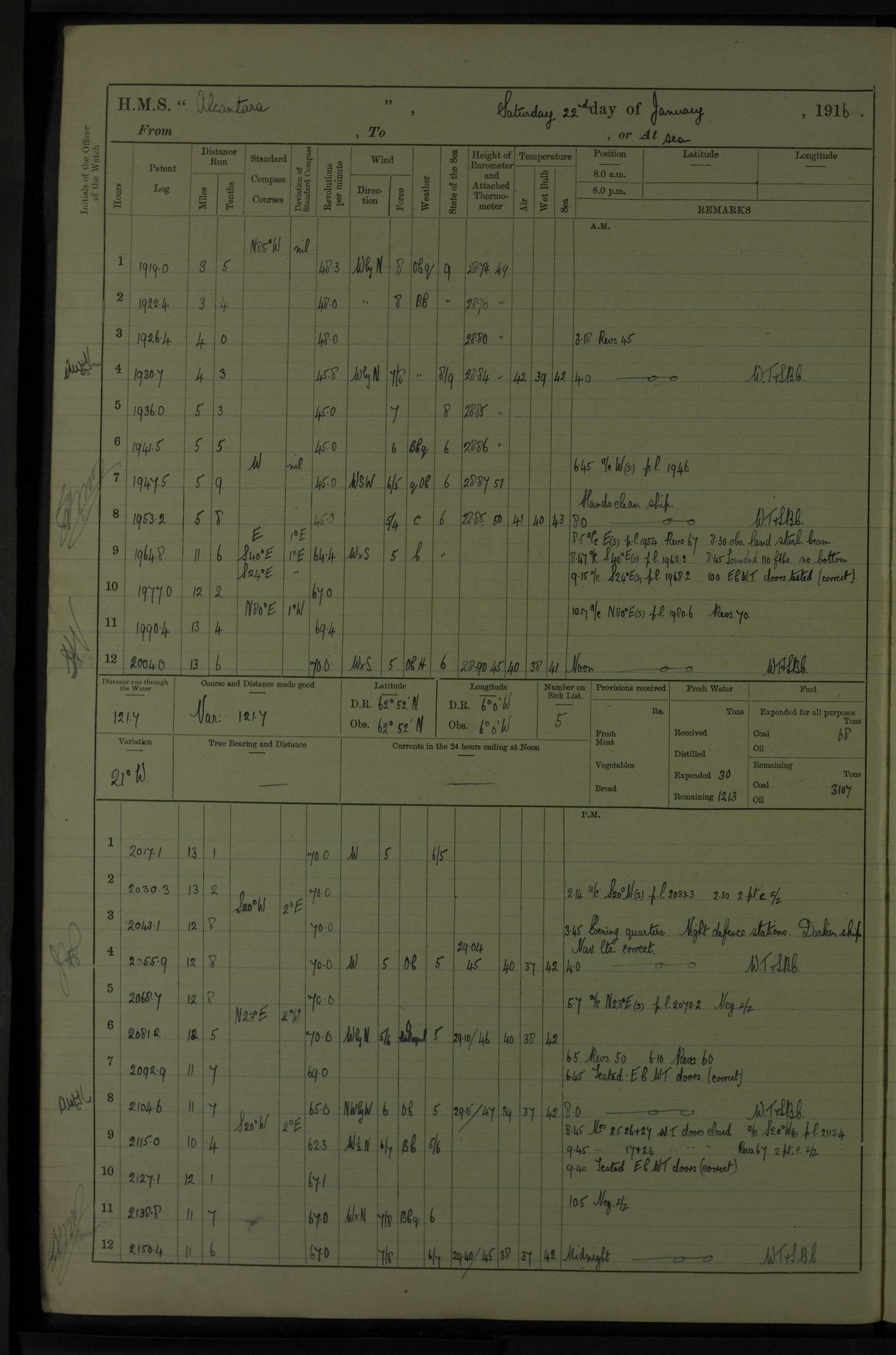
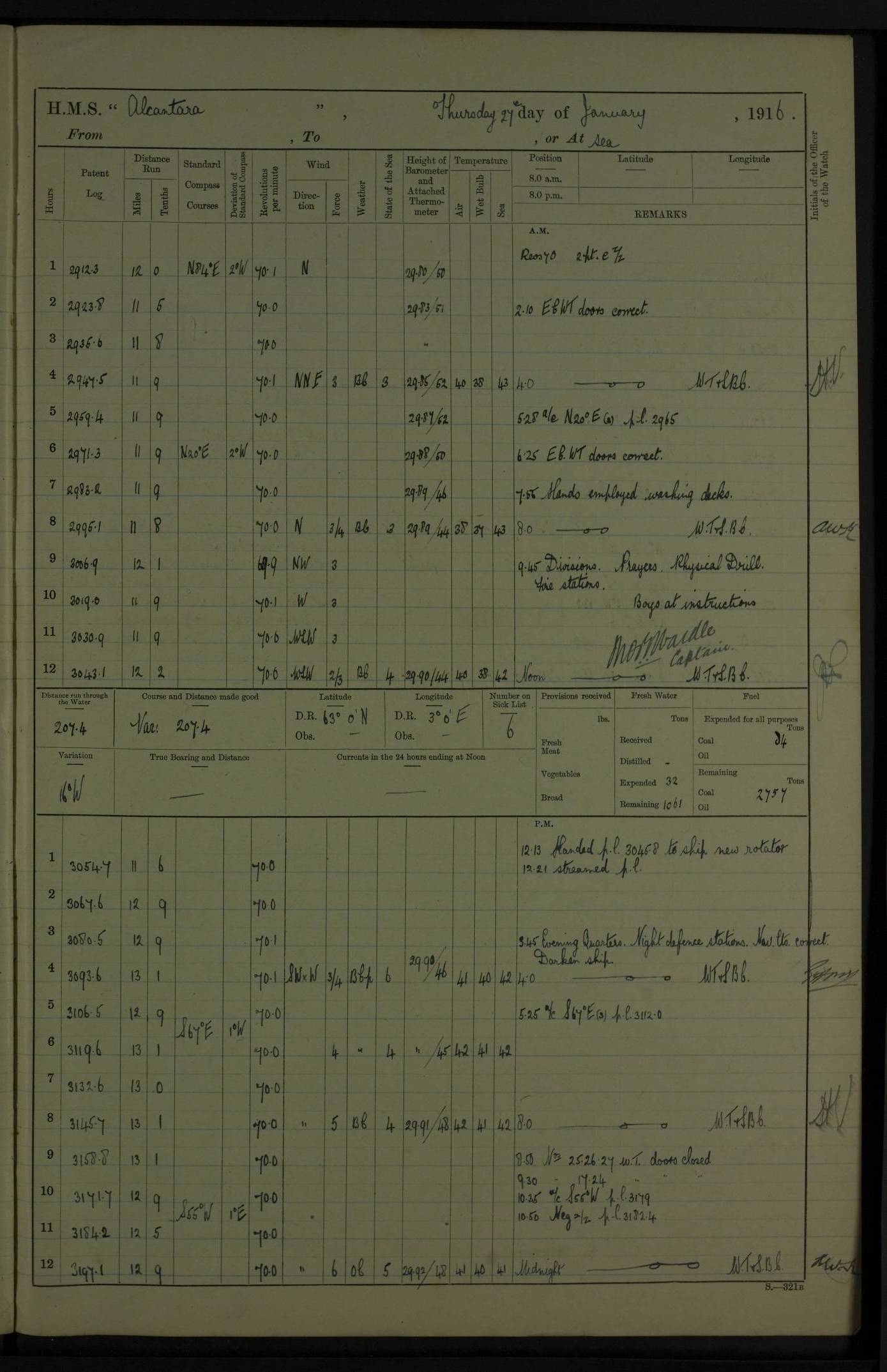
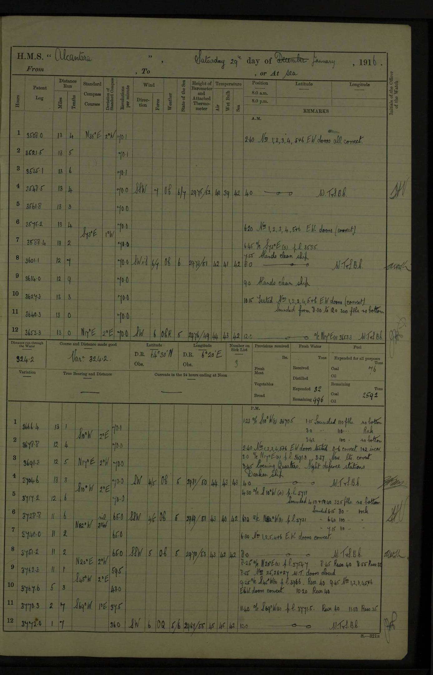