Naval History Homepage and Site Search
Naval History Homepage and Site Search
|
|||||||||||||||||||||||||||||||||||||||||||||||||||||||||||||||||||||||||||||||||||||||||||||||||||||||||||||||||||||||||||||||||||||||||||||||||||||||||
|
|||||||||||||||||||||||||||||||||||||||||||||||||||||||||||||||||||||||||||||||||||||||||||||||||||||||||||||||||||||||||||||||||||||||||||||||||||||||||
|
Fleet Minesweeping Sloop, Flower-class, Azalea-type Ordered 5.15, Acacia, Azalea and Arabis-types built on merchant ship lines, with similar warship-like appearance, Pendant Nos T.43 (9.15), T.47 (1.18). Launched 9.9.15 Swan Hunter. 1200 tons, 262(oa), 250(pp)x33x11ft. TE 1800ihp, 16.5kts. Armament: 2-4.7in, 2-3pdr AA or possibly 2-4in, 2-3pdr AA. Crew: 90. Azalea-types served in Grand Fleet, at Queenstown, and in Mediterranean. Sold 21.12.22 T. E. Evans, Penarth. (British Warships 1914-1919) |
|||||||||||||||||||||||||||||||||||||||||||||||||||||||||||||||||||||||||||||||||||||||||||||||||||||||||||||||||||||||||||||||||||||||||||||||||||||||||
|
|||||||||||||||||||||||||||||||||||||||||||||||||||||||||||||||||||||||||||||||||||||||||||||||||||||||||||||||||||||||||||||||||||||||||||||||||||||||||
|
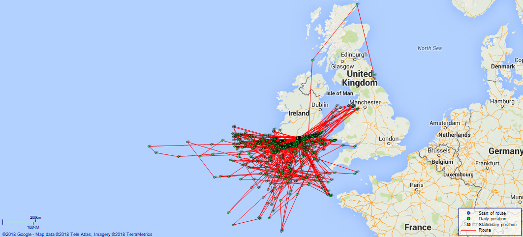
Notes: 1. Latitude/longitude, including for days in port, show representative decimal positions for each day, as calculated by the Old Weather project's analysis program. As such, they differ by varying amounts from the positions recorded, usually at noon, in the log pages. In addition, some latitudes/longitudes have been amended in edited logs for errors in the logs, for errors in identifying locations by the analysis program, or simply for greater accuracy. In all cases, refer to the log-page scans for the positions as originally recorded. Not all log pages contain this information and the ships' positions have therefore often been estimated. 2. Full account of any day is available by clicking on the link above that day. Groups of links refer to log book covers and introductory information; some may be blank. Editor’s notes: Positions (Latitude and Longitude) are given for noon each day, correcting or estimating the position when appropriate. If exact times are not indicated in the log they have, when appropriate, been estimated from the position of the entries (which show times on the left hand side of the log page). Information about sea state is based on the Sea Disturbance Scale where “rough to very rough” indicates waves 5 to 10 feet from peak to trough, “high” indicates waves of 11 to 15 feet, “very high” indicates wave height of 16 to 35 feet and “phenomenal” indicates waves of 36 feet and above. A note is made of numbers on the sick list where this is 5 or more. This and other information from the log is included in square brackets [not in italics] if it is not to be found under “Remarks” on the right hand side of the page. Additional information about geographical locations, terminology and about merchant and foreign naval ships encountered has been provided where identification is reasonably certain, by means of embedded links within the text. Note also that when looking at the maps of the voyages of this ship there may be little apparent movement when Jessamine is on patrol, as she often arrives back at a similar position at noon. Information about the distance travelled each day has therefore been provided in the text below. [There is a little more information about the Azalea Class here, and about Jessamine here] |
|||||||||||||||||||||||||||||||||||||||||||||||||||||||||||||||||||||||||||||||||||||||||||||||||||||||||||||||||||||||||||||||||||||||||||||||||||||||||
|
THE VOYAGES OF HMS JESSAMINE 1915-1918
(Maps prepared using Journey Plotter, developed by Maikel. The Plots can only be approximate. They are made by joining-up positions on successive days, and sometimes positions are not given. There will therefore be occasions when the ship appears to have travelled overland) LOGS FOR OCTOBER 1915 4ef4f8ede53e0a0c910046d0: (https://s3.amazonaws.com:443/oldweather/ADM53-45361/ADM 53-45361-001_0.jpg) [Left hand side of cover] 4ef4f8ede53e0a0c910046d1: (https://s3.amazonaws.com:443/oldweather/ADM53-45361/ADM 53-45361-001_1.jpg) [Right hand side of cover] 4ef4f8ede53e0a0c910046d2: (https://s3.amazonaws.com:443/oldweather/ADM53-45361/ADM 53-45361-002_0.jpg) [Blank page] 4ef4f8ede53e0a0c910046d3: (https://s3.amazonaws.com:443/oldweather/ADM53-45361/ADM 53-45361-002_1.jpg) [Cover of Copy of Log for October 1915, signed by John G Watson, Sub Lieutenant RNR, Navigating Officer] 4ef4f8ede53e0a0c910046d4: (https://s3.amazonaws.com:443/oldweather/ADM53-45361/ADM 53-45361-003_0.jpg) [Blank page] 4ef4f8ede53e0a0c910046d5: (https://s3.amazonaws.com:443/oldweather/ADM53-45361/ADM 53-45361-003_1.jpg) [Page not filled in] 4ef4f8ede53e0a0c910046d6: (https://s3.amazonaws.com:443/oldweather/ADM53-45361/ADM 53-45361-004_0.jpg) [Details of Barometer and Thermometers, as follows:]
4ef4f8ede53e0a0c910046d7: (https://s3.amazonaws.com:443/oldweather/ADM53-45361/ADM 53-45361-004_1.jpg) 13 October 1915 At Walker-On-Tyne Lat 54.966, Long -1.573 [estimated] [Alongside Builders Wharf] [No Meteorological Instruments on board] am: Draft:10’ 0” Fore; 12’ 0” Aft. 8.0am: Commissioned ship with crew of 7 officers and 71 ratings for service in 1st Sloop Flotilla. 9.0am and pm: Hands employed drawing Stores and provisions. 7.30pm: Granted leave to watch till 7.0am. 4ef4f8ede53e0a0c910046d8: (https://s3.amazonaws.com:443/oldweather/ADM53-45361/ADM 53-45361-005_0.jpg) 14 October 1915 At Walker-On-Tyne Lat 54.966, Long -1.573 [Alongside Builders Wharf] [No Meteorological Instruments on board] am and pm: Hands employed drawing Stores and Provisions. 4ef4f8ede53e0a0c910046d9: (https://s3.amazonaws.com:443/oldweather/ADM53-45361/ADM 53-45361-005_1.jpg) 15 October 1915 At Walker-On-Tyne Lat 54.966, Long -1.573 [Alongside Builders Wharf] [No Meteorological Instruments on board] am and pm: Hands employed drawing Stores and Provisions. 4ef4f8ede53e0a0c910046da: (https://s3.amazonaws.com:443/oldweather/ADM53-45361/ADM 53-45361-006_0.jpg) 16 October 1915 At Walker-On-Tyne Lat 54.966, Long -1.573 [Alongside Builders Wharf] [No Meteorological Instruments on board] am and pm: Hands getting stores on board. [Page signed by SH Simpson, Lieutenant Commander] [Note: Salisbury Hamilton Simpson (1884-1951) was Captain of HMS Jessamine from 7 October 1915 to 19 March 1917 and was later awarded the DSO.] 4ef4f8ede53e0a0c910046db: (https://s3.amazonaws.com:443/oldweather/ADM53-45361/ADM 53-45361-006_1.jpg) 17 October 1915 At Walker-On-Tyne Lat 54.966, Long -1.573 [Alongside Builders Wharf] [No Meteorological Instruments on board] am: Hands taking on Stores. pm: Hands at rest. 4ef4f8ede53e0a0c910046dc: (https://s3.amazonaws.com:443/oldweather/ADM53-45361/ADM 53-45361-007_0.jpg) 18 October 1915 At Walker-On-Tyne Lat 54.966, Long -1.573 [Alongside Builders Wharf] [No Meteorological Instruments on board] am and pm: Hands employed coaling ship. pm: Hands employed cleaning ship. 4ef4f8ede53e0a0c910046dd: (https://s3.amazonaws.com:443/oldweather/ADM53-45361/ADM 53-45361-007_1.jpg) 19 October 1915 At Walker-On-Tyne Lat 54.966, Long -1.573 [Alongside Builders Wharf] [No Meteorological Instruments on board] am and pm: Hands employed drawing stores. 4ef4f8ede53e0a0c910046de: (https://s3.amazonaws.com:443/oldweather/ADM53-45361/ADM 53-45361-008_0.jpg) 20 October 1915 From Walker-on-Tyne to Queenstown [now Cobh, Ireland] Lat 55.17, Long -1.47 am: Draft after coaling. 10’ 6” Fore, 12’ 6” Aft. 10.25am: Let go from wharf and proceeded down river assisted by Pilot. 11.10am: Discharged Pilot. 11.30am: Cleared Piers. 11.31am: Set course N5E, speed 12 knots. 11.40am: Increased to 15 knots, streamed patent Log. Commenced zig zagging 2 points on Centre Course. 1.8pm: Dunstanburgh Castle bore N44W, Craster Light House bore N49W, Couquet [Coquet] Island Light House bore S31W. 3.5pm: Altered course N37W. 6.0pm: Suspended zig zagging. [Course and Distance made good: Various 3 miles] [True Bearing and Distance: North Break water S32W, 3 miles] [Fuel Remaining: Coal 226 tons] 4ef4f8ede53e0a0c910046df: (https://s3.amazonaws.com:443/oldweather/ADM53-45361/ADM 53-45361-008_1.jpg) 21 October 1915 From Walker-on-Tyne to Queenstown Lat 58.63, Long -2.97 6.30am: Resumed zig zagging on N62W. am: Vessel zig zagging 2 points on either side of central Course. [am: Log hauled in] 5.8pm: Cape Wrath Light House abeam 2 miles distant, altered course S65W. [pm: No log streamed] 8.0pm: South Ear Light House abeam 11 miles distant. SBC, WBC. 10.20pm: Blas [?] Light House abeam, altered course S36W. [Distance run through the Water: 324 miles] [Course and Distance made good: Various 274 miles] [True Bearing and Distance: Skerrie [Skerry] Light House North 8 miles] [Squally south easterly then south westerly wind force 5 to 7 in pm, with rough sea] 4ef4f8eee53e0a0c910046e0: (https://s3.amazonaws.com:443/oldweather/ADM53-45361/ADM 53-45361-009_0.jpg) 22 October 1915 From Walker-on-Tyne to Queenstown Lat 55.92, Long -7.00 0.18am: Neist Point Light House abeam, altered course S46W and streamed Log 0. 1.25am: Anpinish [?] Light House abeam 3 mile off. 3.0am: Lost by accident, Paunch Mat and patent Log overboard. [Log] [Carried Away] 5.23am: Altered course S11W. 7.15am: Commenced zig zagging one point on either side of central Course S6W. 10.0am: Vessel zig zagging on Central Course. 0.15pm: Increased to 15 knots. 1.30pm: Intrashull [Inishtrahull] bore West, altered course S44E. Vessel zig zagging. 3.45pm: Altered course S58E. 6.10pm: Maiden Rock abeam 1.5 miles distant. 7.8pm: Copeland Island abeam Distant 1.5 miles. 7.48pm: Skulmartin Light Vessel abeam Distant 0.75 miles. 8.28pm: South Rock abeam, altered course S27W. [Distance run through the Water: 340 miles] [Course and Distance made good: Various 279 miles] [True Bearing and Distance: Instrahull [Inishtrahull] Island S23W, 24 miles] [Squally all day, south westerly wind force 9 at 4am, then force 6, with very rough sea in am, south easterly force 5 in pm with rough sea in evening; temperatures recorded from today – noon air temperature 54F, sea temperature 51F] [Note: A Paunch Mat was a thick mat made of strands of rope and used to prevent the yard or rigging from chafing.] 4ef4f8eee53e0a0c910046e1: (https://s3.amazonaws.com:443/oldweather/ADM53-45361/ADM 53-45361-009_1.jpg) 23 October 1915 From Walker-on-Tyne to Queenstown Lat 51.78, Long -7.36 2.5am: Colding [Codling] Light Vessel abeam 1.5 miles distant, altered course S36W. 2.48am: North Arklow Light Vessel abeam 1.5 miles. 3.41am: South Arklow Light Vessel abeam 0.5 miles. 4.30am: Lucifer Bank Light Vessel abeam 3 miles distant. 7.48am: Tuskar Light House abeam 2 miles. 8.0am: Altered course West. 8.12am: Tuskar Light Vessel bearing NW, altered course S79W. Increased to 140 revs. 9.50am: Barrels Light Vessel abeam 1.5 miles distant. 10.0am: Conigsbeg [Coningbeg] Light Vessel abeam 1.6 miles distant, altered course N87W and increased to 15 knots. 10.15am: Commenced zig zagging on Central Course. 2.0pm: Daunt Light Vessel abeam. [Courses and speed as requisite for entering Harbour] 3.0pm: Roche's Point [Roche’s Point] abeam. 5 37pm: All fast to Buoy. [Moored to No 1 Buoy] pm: Draft Arriving 10ft 0in Forward; 12ft 0in Aft. 9.0pm: Rounds Correct. [Page signed] SH Simpson, Lieutenant Commander. [Course and Distance made good: Various 352 miles] [True Bearing and Distance: Mine Head N33W, 15 miles]
THE VOYAGES OF HMS JESSAMINE
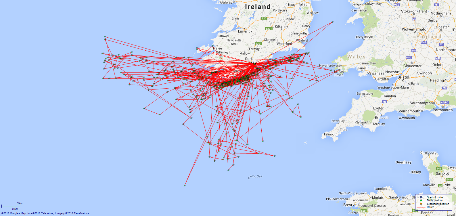
4ef4f8eee53e0a0c910046e2: (https://s3.amazonaws.com:443/oldweather/ADM53-45361/ADM 53-45361-010_0.jpg) 24 October 1915 At Queenstown Lat 51.85, Long -8.28 [estimated] [Alongside Collier] 4.0am: Cast off from SS Carron Park [Carronpark 2 listed here] proceeded to Buoy No 1. All fast to Buoy. [Moored to No 1 Buoy] am: Crew employed cleaning ship. 10.30am: Commenced swinging ship for Compass adjustments. Tug Warrior [there were a number of tugs of this name -- one is listed as a hired tug here] assisting. 1.10pm: Finished adjusting Compasses and cast off Tug. pm: Draft: 10ft 6in Fore, 12ft 6in Aft. 5.10pm: Slipped from Buoy. 5.43pm: Roche Point abeam, increased to 150 revs, set course S22W. 6.0pm: Daunt Rock Light Vessel abeam 0.5 miles distant, altered course S66W and streamed patent Log. 6.55pm: Old Head Kinsale Light House abeam distant 2 miles, reset Log. 7.0pm: Altered course N87W. 8.7pm: Galley Head Light House abeam 2 miles distant, Log 17.5. 9.49pm: Fastnet Light House bore N27W, 2.75 miles. 11.47pm: Bull Light House abeam. [Provisions received: Fresh Meat 215 lbs, Vegetables 400 lbs, Bread 350 lbs] [Fuel Remaining: Coal 249 tons] [Note: SS “Carronpark” was a British cargo ship built in Scotland in 1912 for Denholm Line Steamers, Greenock; in 1920 she went to Anglo-Polish Steamship Line and was renamed “Poznam”, though still managed from UK; in 1923 she went to Scandinavian Shipping Company and was renamed “Ulva”, still managed from Scotland; in 1928 she was managed from Halifax, Nova Scotia, and in 1939 she went to Blane Steamships, London; she was torpedoed by a German submarine to the northwest of Ireland in 1940 (more details here and here). Tug “Warrior” was built in Preston, UK, in 1885 and was hired by the Admiralty from August 1914 to October 1919 and on harbour service before 1917; she is also listed here as being in Cork/Queenstown.] 4ef4f8eee53e0a0c910046e3: (https://s3.amazonaws.com:443/oldweather/ADM53-45361/ADM 53-45361-010_1.jpg) 25 October 1915 From Queenstown to C [Sea] Lat 51.00, Long -11.28 4.0am: Altered course N20E. 6.5am: Eased engines to slow. 6.30am: Increased to 120 revs. 7.0am: Altered course N69W and commenced zig zagging. 8.0am: Altered course S20W. 11.0am: Altered course S72E. 1.20pm: Exercised Action Stations. 1.50pm: Exercised Fire Stations. 3.42pm: Altered course N70W. 4.0pm: Altered course S70W. 6.45pm: Ceased zig zagging. 8.0pm: Dursey Island bore N68E 10.8 miles. 10.30pm: Altered course N71W. 11.35pm: Altered course N21E. [Course and Distance made good: Various 209 miles] [True Bearing and Distance: Fastnet N70.75E, 67 miles] [Sea rough throughout am] 4ef4f8eee53e0a0c910046e4: (https://s3.amazonaws.com:443/oldweather/ADM53-45361/ADM 53-45361-011_0.jpg) 26 October 1915 At C [Sea] Lat 51.00, Long -10.45 2.0am: Altered course S6W. 4.10am: Altered course N35E. 6.15am: Altered course N70W. 6.45am: Commenced zig zagging 2 points on either side of course. 7.15am: Altered course S20W. 9.10am: Divisions and Prayers. 9.30am: Exercised General Quarters. 9.45-10.5am: Adjusting steering gear. 10.15am: Set course N72W. 2.30pm: Altered course S11E, zig zagging 2 points on either side of course. 4.20pm: Ceased ziggagging [sic], altered course S34E. 7.22pm: Set course N10W. 8.35pm: Sighted Gull Rock bearing N19E. 10.15pm: Altered course N69W. 11.15pm: Altered course S21W. [Course and Distance made good: Various 288 miles] [True Bearing and Distance: Gull Rock N10E, 45 miles] 4ef4f8eee53e0a0c910046e5: (https://s3.amazonaws.com:443/oldweather/ADM53-45361/ADM 53-45361-011_1.jpg) 27 October 1915 At C [Sea] Lat 51.23, Long -10.73 1.45am: Altered course S69E. 3.50am: Sighted Gull Rock bearing N41E. 5.30am: Altered course S52W. 6.45am: Zig zagging 2 points of either side of course. 8.5am: Altered course N21E, 2 points on either side of course. 10.0am: Altered course S69E. 10.15am: Altered course S9W. 11.30am: Wind and sea rising rapidly. 0.26pm: Commenced circling round Barque Pehr Ugland in: Lat 51 1.5 N, Long 10 20 W. 4.15pm: Altered course N69W. 5.0pm: Set course S80W. 5.25pm: Reduced to 90 revs. 6.45pm: Great Skellig Light House bore N68E, Gull Rock bore S70E. 11.15pm: Altered course S20W. [Course and Distance made good: Various 288 miles] [True Bearing and Distance: Gull Rock N37E, 27 miles [Squally south westerly wind force 6 or 7 from noon, sea very rough to high in pm; rain for much of day; noon temperature 54F, sea temperature 52F] [Note: “Pehr Ugland” (listed here) was a Norwegian three-masted barque built in Scotland in 1891 for JL Ugland, Arendal.] 4ef4f8eee53e0a0c910046e6: (https://s3.amazonaws.com:443/oldweather/ADM53-45361/ADM 53-45361-012_0.jpg) 28 October 1915 At C [Sea] Lat 51.27, Long -11.33 1.5am: Altered course N44E. 2.20am: Altered course N45W and reduced to 90 revs. 7.0am: SS “Hove to”. 8.0am: Reduced to 70 [revs]. 3.10pm: Altered course East and increased to 120 revs. 6.32pm: Gull Rock Light House bore S79E. 6.40pm: Great Skellig Light House bore N75E. 8.25pm: Altered course S10W and decreased to 8 knots. 10.30pm: Bull Rock bore N56E Distant 14 miles. [Course and Distance made good: Various 204 miles] [True Bearing and Distance: Gull Rock N63E, 44 miles] [Squally north westerly wind force 7-9 in am then gradually reducing in pm, sea very high in am, then rough or very rough until 8pm; rain for much of day] 4ef4f8eee53e0a0c910046e7: (https://s3.amazonaws.com:443/oldweather/ADM53-45361/ADM 53-45361-012_1.jpg) 29 October 1915 At Sea [though not stated at top of page] Lat 50.75, Long -10.74 1.15am: Altered course N10W. 5.20am: Gull Rock Light House bore N60E. 8.15am: Commenced zig zagging 2 points on either side of Course. 10.30am: Altered course N21W. 2.30pm: Altered course N35E. 7.15pm: Altered course S20W. 8.30pm: Altered course S75E. [Course and Distance made good: Various 177 miles] [True Bearing and Distance: D Patrol N12W, 18 miles] [Fuel Remaining: Coal 165.2 tons] [Less windy today but sea very rough in early am and rough in pm] 4ef4f8eee53e0a0c910046e8: (https://s3.amazonaws.com:443/oldweather/ADM53-45361/ADM 53-45361-013_0.jpg) 30 October 1915 At C [Sea, and Queenstown] Lat 51.85, Long -8.28 [estimated] 0.27am: Fasnet [Fastnet] Light House abeam distant 2.6 miles, altered course S89E. 1.0am: Altered course N85E to avoid drifter. 1.13am: Altered course S89E. 3.13am: Galley Head abeam 2.5 miles distant, altered course S85E. 7.2am: Roche’s Point abeam. Draft arriving Fore 9’ 6”; Aft 11’ 6”. 7.50am: Secured alongside Collier “Burn Hope” [Burnhope]. [Alongside Collier] 8.30am: Commenced Coaling. am: 1 Rating discharged to RN Hospital. Hands coaling ship. 3.0pm: Completed coaling ship. 4.0pm: Made fast to No 1 Buoy. Hands cleaning ship. [Moored to No 1 Buoy] 6.0pm: Gave special leave to Red Watch till 7.00am. 9.0pm: Evening Rounds correct. [Provisions received: Fresh Meat 210 lbs, Vegetables 300 lbs, Bread 350 lbs] [Fuel Remaining: Coal 250 tons] 4ef4f8eee53e0a0c910046e9: (https://s3.amazonaws.com:443/oldweather/ADM53-45361/ADM 53-45361-013_1.jpg) 31 October 1915 At Queenstown Lat 51.85, Long -8.28 [estimated] [Moored to No 1 Buoy] 8.35am: One rating returned from RN Hospital. 9.12am: Slipped from buoy. 9.40am: Made fast alongside HMS “Primrose”. [Fast alongside HMS Primrose] am: Hands cleaning ship. 10.30am: Landed Church Parties. [Fast Alongside HMS “Primrose” at Spencer Jetty[Haulbowline]] 1.0pm: Leave to White Watch granted till 10.30pm. 9.0pm: Night Rounds Correct. [Page signed] SH Simpson, Lieutenant Commander. 4ef4f8eee53e0a0c910046ea: (https://s3.amazonaws.com:443/oldweather/ADM53-45361/ADM 53-45361-014_0.jpg) [Log page not filled in] LOGS FOR NOVEMBER 1915 4ef4f8eee53e0a0c910046eb: (https://s3.amazonaws.com:443/oldweather/ADM53-45361/ADM 53-45361-014_1.jpg) [Cover of Copy of Log for November 1915, signed by John G Watson Sub Lieutenant RNR, Navigating Officer] 4ef4f8eee53e0a0c910046ec: (https://s3.amazonaws.com:443/oldweather/ADM53-45361/ADM 53-45361-015_0.jpg) [Blank page] 4ef4f8eee53e0a0c910046ed: (https://s3.amazonaws.com:443/oldweather/ADM53-45361/ADM 53-45361-015_1.jpg) [Page not filled in] 4ef4f8efe53e0a0c910046ee: (https://s3.amazonaws.com:443/oldweather/ADM53-45361/ADM 53-45361-016_0.jpg) [Details of Barometer and Thermometers, as before apart from dates] 4ef4f8efe53e0a0c910046ef: (https://s3.amazonaws.com:443/oldweather/ADM53-45361/ADM 53-45361-016_1.jpg) 1 November 1915 From Queenstown to Patrol Lat 51.07, Long -8.53 am: Draft: Fore 10’ 6”, Aft 12’ 6”. 5.0am: Hands employed preparing for sea. 7 40am: Slipped and proceeded out of Harbour, speed and course as requisite. 8.10am: Roache’s [Roche’s] Point abeam, set course S22W. 8.30am: Daunt Rock abeam 0.25 miles distant, set course S34W, streamed Log and commenced zig zagging 2 points on either side of central Course. 10.5am: Old Head of Kinsale bore N15W. 1.15pm: Made Plain sail. 4.0pm: Quarters. 5.0pm: Took in sail. 5.30pm: Ceased zig zagging. 6.30pm: Reduced to 80 knots [revs], altered course S20W. 6.49pm: Increased to 120 revs. 7.42pm: Altered course S55W. Chasing Steamer. 9.40pm: Altered course S10W, reduced to 8 knots. Midnight: Wind and sea rising. [Course and Distance made good: Various 50 miles] [True Bearing and Distance: Galley Head S14W, 66.5 miles] [Sea becoming rough then very rough in late evening] 4ef4f8efe53e0a0c910046f0: (https://s3.amazonaws.com:443/oldweather/ADM53-45361/ADM 53-45361-017_0.jpg) 2 November 1915 At C [Sea] Lat 50.00, Long -8.95 5.35am: Altered course S60W, gave chase to steamer 6.0am: Questioned SS Canora [probably Canova] bound for London. Lat 50 29 N, Long 8 30 W. 6.30am: Resumed course S20W. Increased to 120 revs and commenced zig zagging. 8.52am: Altered course N8W, challenged British SS Perim bound to Liverpool with General Cargo. 8.59am: Altered course West and reduced to 12 knots. 9.45am: Commenced zig zagging. 6.0pm: Altered course SW. Signalled SS Terek of Sunderland from Foynes to Sunderland. 6.50pm: Reduced to 8 knots. [Course and Distance made good: Various 258 miles] [True Bearing and Distance: Galley Head N, 89 miles] [Sea rough until 8am, then reducing] [Note: SS “Canova” was a British passenger/cargo ship built in Scotland in 1895 for Liverpool, Brazil & River Plate Steam Navigation Company, Lamport & Holt, Liverpool; in 1902 she went to Société Anonyme de Navigation Royal Belge Sud-Américaine, Antwerp, but returned to her original owners in 1908; she was either torpedoed or sunk by a mine from a German submarine off southern Ireland in December 1917, with the loss of 7 lives (more details here). SS “Perim” was a British cargo ship built in Scotland in 1877; from 1902 she was owned by Ellerman-Papayanni Line, Liverpool; she sank off Tarragona, Spain, after a collision with another British ship (SS Wilston) in October 1917 (more details here). SS “Terek” was a British oil tanker built in Sunderland in 1899 for Caucasian Steam Shipping Company; in June 1917 she went to British Tanker Company, London, and was renamed “British Duke”; in 1930 she went to an Italian company and was renamed “Laura Corrado”; she was shelled and torpedoed by a British submarine off Sicily in 1941 (more details here).] 4ef4f8efe53e0a0c910046f1: (https://s3.amazonaws.com:443/oldweather/ADM53-45361/ADM 53-45361-017_1.jpg) 3 November 1915 At C [Sea] Lat 49.95, Long -10.07 6.45am: Commenced zig zagging 2 points on either side of course. Increased to 12 knots. 7.25am: Pumped up Telemotor Tank, ship steering a circular course. 7.35am: Shifted to hand steering gear. 7.50am: Steadied on N70W. 3.0pm: Altered course S48E to close on SS Hartlepool [listed here] from Buenos Ayres to Cork with wheat. 5.0pm: Vessel zig-zagging 2 points on either side of central course. 5.15pm: Altered course S70W and ceased zig zagging. [Course and Distance made good: Various 231 miles] [True Bearing and Distance: Fastnet N32E, 87 miles] [Note: SS “Hartlepool” was a British cargo ship built in Stockton-on-Tees in 1904 for Pool Shipping Company (R Ropner & Company), West Hartlepool; in 1918 she was converted to a tanker; in 1920 she was sold to Anglo-Saxon Petroleum Company, London, and in 1921 was renamed “Purpura”; she was broken up in Japan in 1931 (more details here).] 4ef4f8efe53e0a0c910046f2: (https://s3.amazonaws.com:443/oldweather/ADM53-45361/ADM 53-45361-018_0.jpg) 4 November 1915 At C [Sea] Lat 49.60, Long -8.90 6.15am: Commended [Commenced] zig zagging 2 points on either side of course and increased to 120 revs. 9.35am: Reduced to 90 revs, vessel pitching and straining heavily. 6.15pm: Commenced zig zagging and increased to 120 revs. 9.35pm: Reduced to 90 revs, vessel straining heavily and pitching violently. [Course and Distance made good: Various 220 miles] [True Bearing and Distance: Fastnet Light House N15W, 112 miles] [North easterly wind force 5 to 6 from 6am to noon with very rough sea, force 6 or 7 in pm with high sea; weather mostly fine until midnight; noon temperature 53F, sea temperature 51F] 4ef4f8efe53e0a0c910046f3: (https://s3.amazonaws.com:443/oldweather/ADM53-45361/ADM 53-45361-018_1.jpg) 5 November 1915 At C [Sea] Lat 49.53, Long -9.50 7.0am: Steering gear very unsatisfactory. 7.30am: Connected up Hand gear. 9.6pm: Reverted to steam steering gear. 9.15am: Commenced zig zagging. Noon: Took cast. 80 fathoms no bottom. [Course and Distance made good: Various 208 miles] [True Bearing and Distance: Fastnet Light House N2W, 114 miles] [North easterly wind force 6 in am, with rough or very rough sea, wind and sea decreasing in pm] 4ef4f8efe53e0a0c910046f4: (https://s3.amazonaws.com:443/oldweather/ADM53-45361/ADM 53-45361-019_0.jpg) 6 November 1915 At C [Sea] Lat 49.60, Long -10.01 6.30am: Commenced zig zagging. 3.0pm: SS zig zagging two points on either side of course. 5.22pm: Reduced to 10 knots and ceased zig zagging. [Course and Distance made good: Various 194 miles] [True Bearing and Distance: D S51E, 20 miles] 4ef4f8efe53e0a0c910046f5: (https://s3.amazonaws.com:443/oldweather/ADM53-45361/ADM 53-45361-019_1.jpg) 7 November 1915 At C [Sea and Berehaven] Lat 51.64, Long -9.82 [estimated] 2.0am: Sighted Gull Rock Light bearing N45E, altered course N15E. 4.0am: Fastnet Light House bore N83E, Gull Rock Light House bore N6W. 6.30pm: Sheep Head abeam. 7.0am: Roancarrig abeam. 7 35am: Anchored with Port Anchor and 60 fathoms cable. 4 shackles. Draft 9ft 6in Fore, 11ft 6in Aft. [At Anchor] am and pm: Hands employed painting ship. 1.30pm: Leave granted to Port Watch to 10.0pm. 4.30pm: Landed Liberty men. 10.30pm: Liberty men returned. [Course and Distance made good: Various 190 miles] [Noon position] [Berehaven] [Provisions received: Fresh Meat 70 lbs, Vegetables 235 lbs, Bread 140 lbs] [Fuel Remaining: Coal 148.6 tons] 4ef4f8efe53e0a0c910046f6: (https://s3.amazonaws.com:443/oldweather/ADM53-45361/ADM 53-45361-020_0.jpg) 8 November 1915 At Berehaven Lat 51.64, Long -9.82 6.30am: Weighed Anchor and proceeded alongside collier Hockwood” [probably Hockwold]. [At Anchor Alongside Collier] 8.10am: Commenced coaling. am: Hands employed coaling ship. Noon: Suspended Coaling. 0.45pm: Resumed Coaling. 2.15pm: Finished Coaling. 2.30pm: Cast off from Collier “Hockwood” and made fast alongside SS “Tynemouth” for water. 5.45pm: Landed Liberty men, leave granted till 10.00pm. 10.0pm: Cast off from SS “Tynemouth” and proceeded to anchorage. 11.15pm: Anchored off Furious Pier with Starboard Anchor and 45 fathoms cable. [At Anchor] [Provisions Received: Fresh Meat 230 lbs, Vegetables 500 lbs, Bread 460 lbs] [Fuel Remaining: Coal 246.2 tons] [Note: SS “Hockwold” was a British coal cargo ship built in Sunderland in 1911 for Cory Colliers, London; she was chartered by the Admiralty as a collier (No 661). She sank after a collision with another British ship (SS Intent) off southern Cornwall in September 1917, with the loss of 10 lives (more details here and see listing here). SS “Tynemouth” was a British cargo ship built in Newcastle-upon-Tyne in 1909 for Burnett Steamship Company, Newcastle; she was hired as a collier by the Admiralty; she was to go missing after sailing from Cardiff on 31 December 1915, to Shetlands (more details here and in listing here).] 4ef4f8efe53e0a0c910046f7: (https://s3.amazonaws.com:443/oldweather/ADM53-45361/ADM 53-45361-020_1.jpg) 9 November 1915 At Berehaven Lat 51.58, Long -10.04 [At Anchor] am: Draft. 10ft 6in Fore, 12ft 6in Aft. 5.0am: Hands employed preparing ship for sea. 7.20am: Weighed Anchor and proceeded in search of No 2 Whaler. 8.30am: Anchored in Lawernce [Lawrence] Cove. 8.45am: Liberty men returned on board. 9.10am: Hoisted whaler and proceeded. 9.45am: Sent mail on board HMS Sunflower. 9.50am: Proceeded. 10.12am: Arknakinna [Ardnakinna] Point abeam, passed out off [of] western Entrance. 10.35am: Fair Head abeam, set course S51W. 1.0pm: Gull Rock abeam 3 miles distant, altered course S36W. 1.5pm: Altered course West, vessel rolling heavily with high beam sea. 4.0pm: Boisterous weather continues. 5.17pm: Gull Rock Light House bore N75E. [Course and Distance made good: Various 20 miles] [True Bearing and Distance: Gull Rock bore N65W, Blackball Point bore N39E] [Squally north westerly wind force 6 in pm, with high sea and rain] 4ef4f8efe53e0a0c910046f8: (https://s3.amazonaws.com:443/oldweather/ADM53-45361/ADM 53-45361-021_0.jpg) 10 November 1915 At Patrol Lat 50.82, Long -10.76 [Mercurial Barometer damaged apparently by rolling] 2.0am: Boisterous weather continues. 10.0am: Bad weather continues. 3.55pm: Challenged British steamer [or sloop] “Mountford”. 7.0pm: Weather moderating. [Course and Distance made good: Various 121 miles] [True Bearing and Distance: Fastnet Light house N51E, 57 miles] [Wind north westerly then northerly force 5 to 7-8 until 6pm; sea high at 4am, then very rough or rough until 6pm; rain and hail in am] [Note: It has not been possible to trace a British ship named “Mountford”, though a ship of this name was mentioned in this area in the Log of HMS Venus on 13 August 1914. It is just possible that this was a misheard SS “Mountfields” (listed here as “Blairmore”), a British cargo ship built in West Hartlepool in 1901 for Doughty Shipping Company, West Hartlepool; she went to Northern Navigation Company, Glasgow, in 1915 and was renamed “Blairmore”; she then changed hands several times in UK before going to a company in Croatia and being renamed “Rosina Topic”; in 1933 she went to a Turkish company and became “Altay”; she was scrapped in 1960 (more details here).] 4ef4f8efe53e0a0c910046f9: (https://s3.amazonaws.com:443/oldweather/ADM53-45361/ADM 53-45361-021_1.jpg) 11 November 1915 At Patrol Lat 51.08, Long -10.50 6.30am: Increased to 12 knots and commenced zig zagging. 10.30am: Ceased zig zagging. am: Hands employed redleading. [Course and Distance made good: Various 155 miles] [True Bearing and Distance: Fastnet Light House N52E, 38 miles] [Mist and/or rain for much of day] 4ef4f8efe53e0a0c910046fa: (https://s3.amazonaws.com:443/oldweather/ADM53-45361/ADM 53-45361-022_0.jpg) 12 November 1915 At Patrol Lat 51.15, Long -10.13 3.0am: Weather assuming threatening appearance. 7.15am: Commenced zig zagging. 8.10pm: Gull Rock bore N20W, Fastnet bore S65E, Roancarrig [Roancarrigmore] Light House bore N70E. [Course and Distance made good: Various 189 miles] [True Bearing and Distance: Fastnet Light House N55E, 24 miles] [Mist and rain in am, sea very rough at noon, wind northerly then north easterly in pm, force 5 to 10 with sea very high or phenomenal until 10pm; barometric pressure low and falling until 4pm (when 28.20/56)] 4ef4f8efe53e0a0c910046fb: (https://s3.amazonaws.com:443/oldweather/ADM53-45361/ADM 53-45361-022_1.jpg) 13 November 1915 On Patrol [and at Berehaven] Lat 51.64, Long -9.82 [estimated] Midnight: Course and speed as requisite. 0.30am: Rounded Lonehort Beacon [also known as Lanehort Point]. 1.0am: Anchored at Furious Pier with Starboard Anchor and 45 fathoms cable, 3 shackles. [At Anchor] 6.0am: Hands scrubbing decks. am: Hands employed painting ship and as requisite. 7.45pm: Shortened in Cable. 8 15pm: Weighed and proceeded. Course and speed as required. 9.40pm: Set course S53W, 100 revs. [Noon position] [Berehaven] 4ef4f8efe53e0a0c910046fc: (https://s3.amazonaws.com:443/oldweather/ADM53-45361/ADM 53-45361-023_0.jpg) 14 November 1915 At Patrol Lat 50.68, Long -10.75 8.0am: Commenced zig zagging. 9.0am: Divisions. 4.0pm: Vessel zig zagging. 11.20pm: Fastnet bore N41E. [Course and Distance made good: Various 136 miles] [True Bearing and Distance: Fastnet Light House N49E, 62 miles] [Fuel Remaining: Coal 175.6 tons] [Sea rough in am, reducing in pm] 4ef4f8efe53e0a0c910046fd: (https://s3.amazonaws.com:443/oldweather/ADM53-45361/ADM 53-45361-023_1.jpg) 15 November 1915 At Patrol and Queenstown Lat 51.85, Long -8.28 [estimated] 0.20am: Fastnet Light House abeam 7 miles distant. 4.0am: Galley Head abeam 5.75 miles distant. 6.10am: Old Head Kinsale abeam distant 3 miles. 8.0am: Roche’s Point abeam. Course and speed as requisite for entering Port. 8.43am: Made fast alongside Collier “Kyltonia” [Hyltonia]. Draft 9ft 9in Fore, 11ft 9in Aft. [Alongside Collier] 9.15am: Commenced Coaling. 1.30pm: Finished Coaling, cast of [off] from Collier and proceeded to No 1 Buoy. [Moored to No 1 Buoy] 3.0pm: 1 Rating discharged to Hospital. 4.30pm: Landed Liberty men, leave granted till 7.00am. [Course and Distance made good: Various 140 miles] [Noon position] [Queenstown] [Provisions received: Fresh Meat 85 lbs, Vegetables 200 lbs, Bread 200 lbs] [Fuel Remaining: Coal 246.4 tons] [Note: SS “Hyltonia” was a British cargo ship built in Sunderland in 1911 for Ericsson Shipping Company, Newcastle; in 1919 she went to Maindy Shipping Company and in 1920 was renamed “Maindy Hill”; she changed hands again in 1921 and 1915 (still in British ownership); she was requisitioned by the Admiralty in WW2 and sank off north west England after a collision with an Italian ship (SS Rosario) in 1940 (more details here).] 4ef4f8f0e53e0a0c910046fe: (https://s3.amazonaws.com:443/oldweather/ADM53-45361/ADM 53-45361-024_0.jpg) 16 November 1915 At Queenstown Lat 51.85, Long -8.28 [estimated] [Made fast to No 1 Buoy] 6.5am: Landed Patrol. 7.20am: Liberty men returned. 8.30am: Ship swung to flood tide. am: Dockyard workmen at defects etc. Hands employed cleaning ship and drawing stores. pm: Dockyard workmen on board at defects. 4.50pm: Liberty men landed, leave granted till 10.0pm 6.5pm: Landed Patrol. 1 Stoker left ship for Hospital. Read Warrant No 3. 2 ratings discharged to HMS Colleen for detention barracks. 10.20pm: Liberty men returned. [Provisions received: Fresh Meat 238 lbs, Vegetables 500 lbs, Bread 460 lbs] 4ef4f8f0e53e0a0c910046ff: (https://s3.amazonaws.com:443/oldweather/ADM53-45361/ADM 53-45361-024_1.jpg) 17 November 1915 At Queenstown and Patrol Lat 51.03, Long -8.84 [Moored to No 1 Buoy] 5.0am: Hands employed preparing ship for sea. Draft 10’ 6” Fore, 12’ 6” Aft. 8.20am: Slipped from buoy. 8.30am: Swung and proceeded. 9.0am: Roche’s Point abeam, Course S20W. 9.30am: Daunt Rock Light Vessel abeam, altered course S67W. 10.45am: Old Head Kinsale abeam 1 mile distant. Noon: Vessel zig zagging. 2.15pm: Sighted Fastnet Rock N71W. 5.15pm: Ceased zig zagging. [Course and Distance made good: Various 33.5 miles] [True Bearing and Distance: Galley Head N85W, 4.25 miles] [South easterly wind force 5 in pm, sea rough from 8pm] 4ef4f8f0e53e0a0c91004700: (https://s3.amazonaws.com:443/oldweather/ADM53-45361/ADM 53-45361-025_0.jpg) 18 November 1915 At Patrol Lat 51.67, Long -11.08 7.15am: Altered course N10E and Commenced zig zagging. pm: Hands employed Painting and as required. 5.30pm: Altered course N58E and ceased zig zagging. 9.45pm: Sighted Great Skellig Light House bearing S82E. 11.27pm: Great Skellig Light House bore N68E, Gull Rock Light House bore S58E. [Course and Distance made good: Various 278 miles] [True Bearing and Distance: Great Skellig Light House N71W, 21 miles] [South easterly or southerly wind force 5 with rough sea all day; weather fine; noon temperature 51F, sea temperature 52F] 4ef4f8f0e53e0a0c91004701: (https://s3.amazonaws.com:443/oldweather/ADM53-45361/ADM 53-45361-025_1.jpg) 19 November 1915 At Patrol Lat 51.00, Long -10.33 9.30am: Divisions and Prayers. Exercised “Action” (hands to General Quarters). 10.45am: Secured. 2.0pm: Vessel zig zagging. 5.10pm: Altered course S20W, ceased zig zagging. [Course and Distance made good: Various 212 miles] [True Bearing and Distance: Fastnet Light House N49E, 36 miles] [Wind south easterly force 5 until 4pm, then increasing to force 7 at midnight, sea rough until 1pm, then very rough] 4ef4f8f0e53e0a0c91004702: (https://s3.amazonaws.com:443/oldweather/ADM53-45361/ADM 53-45361-026_0.jpg) 20 November 1915 At Patrol Lat 51.13, Long -10.22 8.30am: Set Main Trysail. 3.0pm: Furled sail. 6.40pm: Great Skellig Light abeam. 9.8pm: Gull Rock Light House abeam. 9.10pm: Great Skellig Light N80E. 11.0pm: Weather moderating [Course and Distance made good: Various 193 miles] [True Bearing and Distance: Fastnet Light Vessel N57E, 27 miles] [Wind still south easterly or southerly force 6 or 7 for most of day, sea rough or very rough] 4ef4f8f0e53e0a0c91004703: (https://s3.amazonaws.com:443/oldweather/ADM53-45361/ADM 53-45361-026_1.jpg) 21 November 1915 At Patrol Lat 51.48, Long -8.58 1.15am: Altered course N20E to close oil Tanker SS Patella, increased to 150 revs. 2.15am: Set course to escort vessel to Queenstown, 120 revs. 7.15am: Fastnet Light House bore North, altered course S88E. 10.10am: Galley Head bore N23W, Old Head Kinsale N50E. 11.20am: Stopped for engine room purposes. 2.15pm: Slow ahead. 2.20pm: Proceeded at 8 knots, set course S80W. 3.0pm: Commenced zig-zagging, altered course S58W. 3.25pm: Altered course to close oil tank. 3.30pm: Set course S85E to escort British SS “Silverlip” [listed here as San Isidoro]. 5.0pm: Daunt Rock Light Vessel abeam 3 miles distant, altered course N64E. 5.50pm: Left “Silverlip” and returned to Patrol, set course S64W, increased to 12 knots. 6.45pm: Old Head Kinsale abeam 5 miles distant, altered course West. 8.17pm: Galley Head abeam. 8.54pm: Fastnet Rock Light House N87W. 9.45pm: Questioned British SS “Barnson” [Barneson] bound for Queenstown with oil. 10.23pm: Fastnet Rock Light House abeam 3 miles distant. [Course and Distance made good: Various 173 miles] [True Bearing and Distance: Kinsale Head N36E, 8.5 miles] [Fuel Remaining: Coal 177 tons] [Sea rough in am, reducing in pm] [Note: SS “Patella” was a British tanker built in Wallsend (Tyne) in 1909 for Anglo-Saxon Petroleum Company, London; she ran aground and was wrecked off Portugal in August 1921 (more details here). SS “Silverlip” was a tanker built in Low Walker (Tyne) in 1914 as “San Isidoro” for Eagle Oil Transport Company, London; in 1914 she was sold to the French Navy and was renamed “Dordogne”; in 1915 she was loaned to Anglo-Saxon Petroleum Company, London, by the French Government and was renamed “Silverlip”; in 1918/9 she returned to the French Navy and became “Dordogne” again; she was scuttled in Brest Roads in June 1940 to avoid capture (more details here and here). SS “Barneson” was a British tanker built in Hebburn (Tyne) in 1914 for Bank Line, Glasgow; in 1915 she was renamed “Oyleric”; in 1937 she was sold to an Italian company and was renamed “Genoano”; in 1941 she went to Petroleos Mexicanos and was renamed “Faja de Oro”; she was torpedoed and sunk by a German submarine off north west Cuba in 1942, with the loss of 10 lives (more details here).] 4ef4f8f0e53e0a0c91004704: (https://s3.amazonaws.com:443/oldweather/ADM53-45361/ADM 53-45361-027_0.jpg) 22 November 1915 At Berehaven Lat 51.64, Long -9.82 [estimated] 7.40am: Entered Bantry Bay. Courses and speed as required. 8.20am: Entered Berehaven. 8.30am: Secured alongside Collier “Venice”. Draft 9’ 9” Fore, 11’ 9” Aft [Alongside Collier] 9 40am: Commenced Coaling. am: Hands coaling ship. pm: Hands employed coaling. 2.30pm: Finished Coaling, cast off from Collier and proceeded to Anchorage. 3.44pm: Let go Starboard Anchor and 45 fathoms cable. Dunboyne [Dunboy] Castle bearing N87W, Semaphore bearing N39E. [At Anchor] 6.0pm: Landed Liberty men, leave granted till 7.00am. [Provisions received: Fresh Meat 80 lbs, Vegetables 140 lbs, Bread 80 lbs] [Fuel Remaining: Coal 246.1 tons] [Note: SS “Venice” was a British cargo ship built in Scotland in 1914 for Furness, Withy & Company, West Hartlepool; in 1922 she went to Johnstone Line and was renamed “Wigmore”; in 1926 she went to a Norwegian company and was renamed “Mai”; in 1931 she went to another Norwegian company and became “Herleik”; in 1940 she was sold to a company in Hong Kong; she was seized by Japan in 1941 and was renamed “Yulin Maru”; she was ran aground and was wrecked off French Indo-China in 1945 (more details here).] 4ef4f8f0e53e0a0c91004705: (https://s3.amazonaws.com:443/oldweather/ADM53-45361/ADM 53-45361-027_1.jpg) 23 November 1915 At Berehaven Lat 51.63, Long -9.92 [estimated] [At Anchor] am and pm: Hands employed painting ship. 4.30pm: Landed Liberty men. Leave granted till 7.00am. Read Warrants No 4 and 5. 4ef4f8f0e53e0a0c91004706: (https://s3.amazonaws.com:443/oldweather/ADM53-45361/ADM 53-45361-028_0.jpg) 24 November 1915 At Berehaven [and Bantry Bay] Lat 51.60, Long -9.93 [very rough estimate] 7.0am: Liberty men returned. 9.0am: General Exercise. 9.10am: Divisions and Prayers. 10.40am [9.40am?]: Shortened in to 2 shackles. 9.20am: Exercised Away All boats crews. 9.50am: Hands at Physical Drill. 10.30am: Weighed by hand, proceeded course and speed as required leaving harbour. 11.30am: Ardenakinna [Ardnakinna] Point abeam, set course S30W. 0.45pm: Altered course West [should presumably be East]. 1.20pm: Roancarrig abeam. 1.40pm: Commenced Target Practice. 2.50pm: Suspended Target Practice. 3.0pm: Target in and proceeded into Harbour, course and speed as requisite. 3.50pm: Anchored with Starboard Anchor and 4 shackles, 60 fathoms cable. CG [Coastguard] bore N37E, Dunboyne Castle S81W. [At Anchor] 5.30pm: Landed Liberty men leave granted till 10.00pm. 10.20pm: Liberty men returned. [Course and Distance made good: 5 miles] [Bearing and Distance: off CGS [Coast Guard Station] N37E, Dunboyne Castle S81W] [these are anchor bearings, not noon position] [Noon position] [In Bantry Bay] 4ef4f8f0e53e0a0c91004707: (https://s3.amazonaws.com:443/oldweather/ADM53-45361/ADM 53-45361-028_1.jpg) 25 November 1915 From Berehaven to Sea [though not stated at top of page] Lat 51.10, Long -9.97 [At Anchor] 8.0am: Commenced heaving up Anchor. 8.20am: Weighed Anchor and proceeded. 8.28am: Ardnakinna Point abeam, altered course S26W. 8.45am: Commenced zig zagging 2 points on either side of course. am: Hands employed cleaning ship. Exercised Physical Drill. 1.0pm: SS zig zagging. 1.30 to 3.30pm: Ordinary Seamen and Boys to seamanship class. 5.15pm: Set course S26W, suspended zig zagging and reduced to 8 knots. 6.45pm: Spoke to SS “Pavia” [Pavia (1) listed here] of Liverpool from Alexandra to Bristol Cargo of Cotton Sead [Seed?]. [Course and Distance made good: S2W, 30.75 miles] [True Bearing and Distance: Fastnet Light House N61E, 23 miles] [Note: SS “Pavia” was a British cargo ship built in Belfast in 1897 and owned by Cunard Steamship Company, Liverpool; she was scrapped in 1928.] 4ef4f8f0e53e0a0c91004708: (https://s3.amazonaws.com:443/oldweather/ADM53-45361/ADM 53-45361-029_0.jpg) 26 November 1915 At Patrol Lat 50.40, Long -11.01 4.25am: Altered course West. Questioned Norwegian Steamer W[?]stad Manchester to Baltimore. 6.50am: Questioned British ship “Filamar” [?] Glasgow for Australia. 10.30am: Exercised General Quarters. 10.50am: Secured and Dispersed. 0.10pm: Altered course S70W. Questioned British SS Nigeria [listed here] from Liverpool to West Africa. 0.35pm: Set course S70E and commenced zig zagging. pm: Hands employed painting boats, Davits and waterways. 4.10pm: Exercised “Away seaboats Crew”. 4.35pm: Proceeded S20W, 120 revs. 5.30pm: Suspended zig zagging and reduced to 8 knots. [Course and Distance made good: Various 269 miles] [True Bearing and Distance: Fastnet Light House N63E, 80.75 miles] [Note: It has not been possible to trace the ships seen at 4.25am and 6.50am. SS “Nigeria” was a British passenger/cargo ship built in Middlesbrough in 1901 for African Steamship Company (Elder, Dempster & Company), London; in November 1916 she was chartered to the Admiralty as an accommodation ship (RFA Nigeria); in March 1917 she caught fire in Murmansk, Russia, was scuttled but later refloated and repaired; in 1918 she was converted to cargo only for The Shipping Controller, London; she was sold to Clause Langdon, London, in 1920 and in 1921 to French company Cie Marseillaise de Navigation a Vapeur, Marseilles, when she was renamed “Niger”; she was broken up in Italy in 1931 (more details here and here).] 4ef4f8f0e53e0a0c91004709: (https://s3.amazonaws.com:443/oldweather/ADM53-45361/ADM 53-45361-029_1.jpg) 27 November 1915 On Patrol [though not stated at top of page] Lat 49.90, Long -10.00 7.40am: Altered course N0.25W and commenced zig zagging. 8.0am: Altered course S75W to head of[f] trawlers. 8.30am: Closed and spoke to British Trawler “Maristo”. 9.0am: Altered course S5E zig zagging two points on either side of course. 1.22pm: Altered course to N10W to close Sailing vessel, vessel steering various courses. 2.2pm: Questioned Canadian Schooner “Kenneth C” [listed here] Bridgetown from Parrsborough [Parrsboro, Nova Scotia] to Havre with timber. 5.0pm: Vessel zig zagging two points on course. [Course and Distance made good: Various 232 miles] [True Bearing and Distance: Fastnet Light House [blank]] [Sea rough in evening] [Note: ST “Maristo” was built in Middlesbrough in 1914 and registered in Milford as M14; in December 1915 she was requisitioned by the Admiralty and converted to a minesweeper (No 1978); in 1917 she went to an owner in Fleetwood and was registered there as FD437 in 1919 when she was returned to her owners; she was renamed “Caldew” in 1921; in 1938 she went to an owner in Hull and in 1939 she was sunk by a German submarine off the Faroe Islands (more details here and here). “Kenneth C” was a schooner built in Port Greville, Nova Scotia, in 1907 and registered in Bridgetown, Barbados.] 4ef4f8f0e53e0a0c9100470a: (https://s3.amazonaws.com:443/oldweather/ADM53-45361/ADM 53-45361-030_0.jpg) 28 November 1915 At C [Sea] Lat 50.10, Long -10.08 8.15am: Commenced zig zagging. 9.50am: Altered course S75W to close Barque. 10.40am: Norwegian Barque [blank] Antofagasta to Mersey with nitre. Position Lat 49 52 N, Long 10 4 W. 10.55am: Set course N20E and resumed zig zagging. 5.13pm: Ceased zig zagging and reduced to 8 knots. 8.40pm: Altered course N80W to close SS and increased to 150 revs. 9.0pm: Spoke SS “St Louis” [there were several ships of this name at this time] Liverpool - New York. 10.0pm: Set course N82E and reduced to 8 knots. [Distance run through the Water: 225 miles] [Course and Distance made good: Various 198 miles] [True Bearing and Distance: Fastnet Light House [blank]] [Sea rough early and late in day] [Note: The most likely identity for SS “St Louis” is this ship, a passenger liner built in Philadelphia in 1894 for International Navigation Company, USA, and operated by American Line; she was commissioned in the US Navy in 1898 and was decommissioned and returned to her owners later that year; she then carried passengers between New York and Liverpool for many years; in 1918 she was commissioned in the US Navy and was renamed “Louisville” (SP-1644); she was decommissioned in September 1919, was returned to her owners and became “St Louis” again; in 1920 she caught fire while being refitted as a passenger liner, was scuttled then refloated; she was sold in 1925 and towed to Italy to be scrapped.] 4ef4f8f0e53e0a0c9100470b: (https://s3.amazonaws.com:443/oldweather/ADM53-45361/ADM 53-45361-030_1.jpg) 29 November 1915 At C [Sea] Lat 51.05, Long -10.50 am and pm: Hands employed painting ship. 9.30am: Altered course N to close Sailing ship. 10.35am: Closed and spoke ship “Clevedon” [possibly this ship] Liverpool to Pensacola. 2.0pm: Vessel zig zagging on central course S20W. 8.5pm: Altered course East and increased to 120 revs. Guns crew closed up, vessel refused to answer signals and extinguished all lights. 9.45pm: Spoke British SS “Etonian” of Liverpool who had sent out SOS having mistaken HMS “Jessamine” for enemy Submarine. Ordered her to cancell [cancel] signal. 10.10pm: Sighted and signalled HMS Mallow and formed line ahead. 10.15pm: Set course NE, 100 revs. [Course and Distance made good: Various 230 miles] [True Bearing and Distance: Fastnet Light House N78W, 39 miles] [Fuel Remaining: Coal 172.6 tons] [Sea rough at times in am] [Note: SV “Clevedon” was British sailing ship built in Liverpool in 1873 as “Chrysomene” for Liverpool Shipping Company, Liverpool; she was sold to a German company in 1901 and was renamed “Elfrieda”; in 1914 she was sold to Clutha Shipping Company, Glasgow, and was renamed “Clevedon”; she became a coal hulk in 1922 and was scuttled in 1930 off south western Australia (more details here). SS “Etonian” was a British passenger/cargo ship built in West Hartlepool in 1898 as “Chicago” for Wilson Line, Hull; in 1904 she went to Frederick Leyland & Company, Liverpool, and was renamed “Etonian”; she was torpedoed and sunk by a German submarine off southern Ireland in March 1918, with the loss of 7 lives (more details here).] 4ef4f8f1e53e0a0c9100470c: (https://s3.amazonaws.com:443/oldweather/ADM53-45361/ADM 53-45361-031_0.jpg) 30 November 1915 [To and] At Queenstown Lat 51.85, Long -8.28 [estimated] 1.0am: Steaming in “Single line ahead”, HMS “Mallow” astern. 4.54am: Galley Head abeam 14.5 miles distant, increased to 120 revs. 6.5am: Old Head Kinsale abeam 4.5 miles distant, altered course N60E. 7.3am: Daunt Rock Light Vessel abeam. 7.30am: Roache’s [Roche’s] Point abeam, entered Port of Queenstown. 8.15am: Made fast Alongside Collier. [Alongside Collier] 9.0am: Commenced Coaling. 10.0am: Discharged 2 ratings to Hospital 1 cot case and 1 walking with doctor. am: Draft 9’ 7” Fore, 11’ 6” Aft. Hands employed coaling. 1.0pm: Cast of [off] from Collier and proceeded to Spencers Wharf assisted by Tug “Hellesport” [Hellespont]. 2.10pm: Made fast. [Fast alongside Spencer’s Jetty] pm: Hands employed cleaning ship. Draft 10’ 6” Fore, 12’ 6” Aft. 5.10pm: Leave granted till 7.00am 6.0pm: Landed liberty men. [Provisions received: Fresh Meat 110 lbs, Vegetables 500 lbs, Bread 160 lbs] [Fuel Remaining: Coal 248 tons] [Note: “Hellespont” (listed here) was a Robust-class deep sea rescue paddle tug built in Hull in 1910; she was moved to Malta in 1922; she was sunk in Malta by German/Italian aircraft in 1942, was later salvaged then scuttled outside Grand Harbour.] LOGS FOR DECEMBER 1915 4ef4f8f1e53e0a0c9100470d: (https://s3.amazonaws.com:443/oldweather/ADM53-45361/ADM 53-45361-031_1.jpg) [Cover of Copy of Log for December 1915, signed by Navigating Officer (as before)] 4ef4f8f1e53e0a0c9100470e: (https://s3.amazonaws.com:443/oldweather/ADM53-45361/ADM 53-45361-032_0.jpg) [Blank page] 4ef4f8f1e53e0a0c9100470f: (https://s3.amazonaws.com:443/oldweather/ADM53-45361/ADM 53-45361-032_1.jpg) [Page not filled in] 4ef4f8f1e53e0a0c91004710: (https://s3.amazonaws.com:443/oldweather/ADM53-45361/ADM 53-45361-033_0.jpg) [Details of Barometer and Thermometers, as before (apart from dates)] 4ef4f8f1e53e0a0c91004711: (https://s3.amazonaws.com:443/oldweather/ADM53-45361/ADM 53-45361-033_1.jpg) 1 December 1915 At Queenstown Lat 51.85, Long -8.28 [estimated] [Alongside Spencer Jetty] 8.20am: Let go from Spencer’s Wharf and proceeded assisted by Tug “Hellespont”. 8.40am: Made fast to No 1 Buoy. [Fast to No 1 Buoy] am: Hands employed as required. Dockyard Employees on board executing repairs. 5.15pm: Landed Liberty men, leave granted till 10.00pm. 8.0pm: Dockyard employees left. 10.0pm: Liberty men returned to ship read, Warrant No 3. 11.0pm: 1 Prisoner discharged to HMS Collen [Colleen]. 4ef4f8f1e53e0a0c91004712: (https://s3.amazonaws.com:443/oldweather/ADM53-45361/ADM 53-45361-034_0.jpg) 2 December 1915 At Queenstown Lat 51.74, Long -8.18 [Moored to No 1 Buoy] am: Hands employed preparing ship for sea and scrubbing decks. 1 Rating discharged to Hospital. 9.40am: Read warrant No 4 and discharged 1 Prisoner to HMS Colleen. 11.10am: Slipped from Buoy and proceeded out of Harbour, speed and Courses as requisite. 11.30am: Roche Point abeam 0.5pm: Pollock Rock buoy abeam, altered course S84E, 10 knots. 0.45pm: Altered course S20W and commenced zig zagging. 1.35pm: Crew exercised at Modified sweep. 3.25pm: Daunt Rock Light Vessel abeam, altered course N21E. 4.10pm: Roche Point abeam, entered Queenstown harbour. 4.42pm: Came to anchor with Starboard Anchor and 4 Shackles:- 60 fathoms cable. Bar Light Bore S81W, Buoy F white light N54W, Buoy F white light N27W. [At Anchor] [Course and Distance made good: Various 4 miles] [True Bearing and Distance: Roche's Point N59W, 4 miles] 4ef4f8f1e53e0a0c91004713: (https://s3.amazonaws.com:443/oldweather/ADM53-45361/ADM 53-45361-034_1.jpg) 3 December 1915 From Queenstown to Patrol Lat 51.49, Long -8.82 [At Anchor] 8.0am: Shortened in Cable. 8.34am: Weighed anchor and proceeded, Courses and speed as requisite. 9.0am: Roche Point abeam, set course S18W, 120 revs. 9.20am: Daunt Rock Light Vessel abeam. 9.45am: Altered course S86W, SS zig zagging. 10.35am: Old Head Kinsale abeam, set course West. Noon: Galley Head bore N67W. 0.27pm: Galley Head abeam distant 5 miles. 2.0pm: Zig zagging. 3.20pm: Fastnet Light House abeam 3.5 miles. 4.30pm: Questioned Norwegian Barque Glitre from Skaggerack [Skagerrak] to Cardiff, Lat 51 10.5 N, Long 9 59.5 W. 10.50pm: Gull Rock bore N10W. 11.35pm: Gull Rock bore N35W. [Course and Distance made good: Various 29.5 miles] [True Bearing and Distance: Galley Head N66W, 5.5 miles] [Note: SV “Glitre” was a barque built in France in 1897 as “Canrobert” for SA de Voiliers Nantais, Nantes; in 1907 she went to A/S Glitre, Christiania, Norway, and was renamed “Glitre”; in 1924 she went to a German owner; she was broken up at Hamburg in 1926.] 4ef4f8f1e53e0a0c91004714: (https://s3.amazonaws.com:443/oldweather/ADM53-45361/ADM 53-45361-035_0.jpg) 4 December 1915 On Patrol Lat 51.10, Long -10.21 8.0am: Commenced zig zagging. 9.20am: Shipped hand steering gear, engineers repairing steam. 0.9pm: Steering gear correct, reverted to steam steering gear. 2.13pm: Commenced zigzagging. 7.50pm: Bull Light House abeam 7 miles distant. 9.15pm: Fastnet Light House bore S53E, Bull Light House bore N22W. [Course and Distance made good: Various 230 miles] [True Bearing and Distance: Fastnet N52E, 28.5 miles] 4ef4f8f1e53e0a0c91004715: (https://s3.amazonaws.com:443/oldweather/ADM53-45361/ADM 53-45361-035_1.jpg) 5 December 1915 At Patrol Lat 51.10, Long -10.29 7.15am: Commenced zig zagging. 7.55am: Mizen Head bore S75E, Bull Light House bore N23E. 3.0pm: Vessel zig zagging. 4.15pm: Altered course S65E and increased to 140 revolutions. Chasing a steamer. [Course and Distance made good: Various 208 miles] [True Bearing and Distance: Bull Light House N1W, 29.5 miles] 4ef4f8f1e53e0a0c91004716: (https://s3.amazonaws.com:443/oldweather/ADM53-45361/ADM 53-45361-036_0.jpg) 6 December 1915 At Patrol Lat 51.39, Long -10.09 5.37am: Sighted Bull Light House bearing N23E. 9.45am: Reduced to 9 knots. 9.50am: Exercised Sweep. 11.0am: Sweep on board. Noon: Mezzin [sic] Head bore S78E. 6.30pm: Wind and sea increasing. [Course and Distance made good: Various 204 miles] [True Bearing and Distance: Bull Light House N39W, 13 miles] [South westerly wind force 6 from noon to 8pm, sea very rough throughout pm; rain or showers for most of day; noon temperature 51F, sea temperature 50F] 4ef4f8f1e53e0a0c91004717: (https://s3.amazonaws.com:443/oldweather/ADM53-45361/ADM 53-45361-036_1.jpg) 7 December 1915 At Patrol Lat 51.03, Long -10.17 [am: Mercurial barometer injured [?]] 7.30am: Increased to 120 revs and commenced zig zagging. 8.30am: Altered course S22W to close on Norwegian Barque “Wanka” Halifax to Liverpool. Position 51 19 N, 10 10 W. 9.15pm: Set course S. Divisions and prayers and general Quarters. am: Hands employed refitting and red-leading and as required. 2.0pm: SS zig zagging on centre course. 5.13pm: Altered course N70W, reduced to and ceased to zig zag. [Course and Distance made good: Various 192 miles] [True Bearing and Distance: Fastnet Light House N33E, 13.5 miles] [Fuel Remaining: Coal 182.4 tons] [Westerly or south westerly wind force 4 to 6 all day, sea rough in am and in evening] [Note: It has not been possible to trace the barque mentioned at 8.30am.] 4ef4f8f1e53e0a0c91004718: (https://s3.amazonaws.com:443/oldweather/ADM53-45361/ADM 53-45361-037_0.jpg) 8 December 1915 From Patrol to Berehaven, at Berehaven Lat 51.64, Long -9.82 [estimated] 6.30am: Sheet [Shee] Head abeam, entered Bantry Bay. 6.45am: Stopped to make repairs to steering gear. 7.15am: Proceeded. 7.20am: Rounded Lonehort [Lanehort] Rock. 8.0am: Made fast to Collier “Venice”. Draft 9’ 9” Fore, 11’ 6” Aft. [Alongside Collier] 9.0am: Commenced Coaling. Noon: Finished Coaling. 0.55pm: Slipped from Collier and proceeded to anchorage. 1.25pm: Anchored with Starboard Anchor and 60 fathoms cable. [At Anchor] pm: Hands employed cleaning ship. 5.0pm: Liberty men landed till 7.00am. [Fuel Remaining: Coal 248 tons] [Note: For details of SS “Venice” see 22 November 1915 in this log.] 4ef4f8f1e53e0a0c91004719: (https://s3.amazonaws.com:443/oldweather/ADM53-45361/ADM 53-45361-037_1.jpg) 9 December 1915 At Port Berehaven Lat 51.64, Long -9.82 [estimated] [At Anchor] 7.0am: Liberty men returned. am: Hands employed refitting and as required. pm: Hands employed Painting. 4.0pm: 3 ratings joined ship. 5.30pm: Landed liberty men till 9.30pm. 9.30pm: Liberty men returned on board. 4ef4f8f1e53e0a0c9100471a: (https://s3.amazonaws.com:443/oldweather/ADM53-45361/ADM 53-45361-038_0.jpg) 10 December 1915 At Port Berehaven Lat 51.66, Long -9.64 [estimated] [At Anchor] am: Bearings: Flag Staff S1W, Pier S33W, Pier S63E. Draft: 10’ 5” [Fore], 12’ 3” [Aft]. 10.40am: Weighed Port Anchor. 11.0am: Weighed Starboard Anchor and proceeded. 11.30am: Roancarrig abeam. Noon: Courses and speed as requisite. 0.40pm: Anchored with Port Anchor and 4 shackles, 60 fathom cable. [At Anchor] 5.30pm: Liberty men landed. Leave granted till 9.30pm. 9.30pm: 1st batch of libertymen returned. 10.40pm: 2nd batch of libertymen returned and whilst dinghy was alongside ladder it capsized. All men reported safe, dispatched whaler to search for dinghy and land to find 2 absentees. 4ef4f8f1e53e0a0c9100471b: (https://s3.amazonaws.com:443/oldweather/ADM53-45361/ADM 53-45361-038_1.jpg) 11 December 1915 At Castletownbere Lat 51.645, Long -9.90 [estimated] [At Anchor] 1.30am: Whaler returned to ship, not having recovered dingy. 8.15am: Shortened in Cable to 2 shackles. 9.20am: Dingy returned in tow of whaler. 9.30am: Weighed anchor and proceeded. 9.40am: Cleared Bantry Harbour. 10.2am: Sheelane Island abeam 0.33 miles distant. 10.15am: Shot head abeam 0.33 miles distant. 10.30am: Roancarrig abeam. [Courses and speed as requisite] 10.45am: Stopped and received absentee from HMS “Primrose”. 10.50am: Anchored of [off] Dinish Island. 1.10pm: Weighed Anchor and proceeded as requisite. 1.30pm: Arknakinnia [Ardnakinna] Point abeam, set course S11W. pm: Hands employed painting. 2.25pm: Mizin [Mizen] Head abeam distant 3 miles. 9.40pm: Altered course S20W and reduced to 8 knots. Midnight: Altered course N70W. [North westerly wind force 5 in pm, sea rough at midnight] 4ef4f8f2e53e0a0c9100471c: (https://s3.amazonaws.com:443/oldweather/ADM53-45361/ADM 53-45361-039_0.jpg) 12 December 1915 At Patrol Lat 50.66, Long -9.65 4.30am: Increased to 120 [revs], wind and sea increasing. SS losing steerage way. 3.8pm: Sighted Fastnet Light House bearing N11E. 5.0pm: Reduced to 80 revs. Fastnet Light House dipped. 6.0pm: Stopped for engine room repairs. 6.15pm: Proceeded 8 knots. [Course and Distance made good: Various 180 miles] [True Bearing and Distance: Fastnet Light House N2E, 44 miles] [Wind northerly or north westerly force 7 or 8 in am, with high to phenomenal sea; wind and sea reducing considerably in pm; weather fine; noon temperature 46F, sea temperature 50F] 4ef4f8f2e53e0a0c9100471d: (https://s3.amazonaws.com:443/oldweather/ADM53-45361/ADM 53-45361-039_1.jpg) 13 December 1915 At Patrol Lat 49.90, Long -9.57 7.40am: Set course S70W, 120 revs and commenced zig zagging. am: Hands employed painting and redleading. 11.15am: Altered course N20E to pick up Life boat Air tank. 11.30am: Picked up air tank, no distinguishing mark on same, set course N20E. 5.0pm: Suspended zig zagging. [Course and Distance made good: Various 210 miles] [True Bearing and Distance: Fastnet Light House N1W, 89.5 miles] 4ef4f8f2e53e0a0c9100471e: (https://s3.amazonaws.com:443/oldweather/ADM53-45361/ADM 53-45361-040_0.jpg) 14 December 1915 At Patrol Lat 49.50, Long -9.81 1.10am: Altered course N70W. Wind and sea rising. 1.55am: Altered course to Starboard to clear SS. 7.0am: Increased to 120 revs and commenced zig zagging. 8.0am: SBC, WBC. Ceased zig zagging set in dense fog. 11.30am: Weather cleared, resumed zig zagging. pm: Hands employed setting up Protection mates [mats] and redleading. SS zig zagging. 8.0pm: S50E to close steamer. 8.30pm: Spoke Dutch steamer SS “Ph[?]” [name off edge of page, just possibly Phecda] Rotterdam to New York in Ballast. [Course and Distance made good: Various 225 miles] [True Bearing and Distance: Fastnet Light House N3.5E, 104 miles] [Wind south westerly force 5 or 6 in am, with rough or very rough sea, wind and sea reduced in pm] [Note: SS “Phecda” was a Dutch cargo ship built in Rotterdam in 1906 for Van Nievelt, Goudriaan & Company Stoomvaart-Maatschappij, Rotterdam; she was seized by the US Government in New York in November 1918 and returned to her owners in 1919; in 1922 she went to a Germany company and was renamed “Hildegard”; she went to another German company in 1925 and became “Frithjof”; in 1926 she changed hands again and became “Tagila”; she was scuttled by the Allies in the Skagerrak in 1945 (more details here).] 4ef4f8f2e53e0a0c9100471f: (https://s3.amazonaws.com:443/oldweather/ADM53-45361/ADM 53-45361-040_1.jpg) 15 December 1915 At Patrol Lat 49.93, Long -9.67 2.5am: Altered course to Starboard to clear HM Sloop “Sunflower”. 7.20am: Wind veered to WNW and increased in force. 8.10am: Commenced zig zagging. 10.50am: Closed and spoke Spanish SS “Adelina” [possibly this ship], Liverpool for Havana. pm: Hands employed red-leading and veering boat falls. 4.40pm: Reduced to 80 revs and suspended zig zagging. [Course and Distance made good: Various 230 miles] [True Bearing and Distance: Daunt Light Vessel N26E, 110 miles] [Fuel Remaining: Coal 178.2 tons] [Sea rough through middle of day] [Note: SS “Adelina” was a Spanish cargo ship built in Scotland in 1914 for Linea de Vapores Serra, Bilbao; she went to another Spanish company in 1920 and was renamed “Guadalquivir”; in 1926 she changed hands again (still Spanish) and became “Cobetas”; she was laid up in Belfast from 1937 to 1939 during the Spanish Civil War; she was broken up in Spain in 1969.] 4ef4f8f2e53e0a0c91004720: (https://s3.amazonaws.com:443/oldweather/ADM53-45361/ADM 53-45361-041_0.jpg) 16 December 1915 At Queenstown Lat 51.85, Long -8.28 [estimated] 1.25am: Altered course to Port to clear steamer. 2.35am: Sighted Old Head Kinsale bearing N10E. 6.15am: Increased to 100 revs, altered course N28E, Old Head of Kinsale 10 miles off, altered course N35E. 7.20am: Daunt Rock Light Vessel abeam, altered course N20E. 7.48am: Roche’s Point abeam, entered Queenstown Harbour. Draft 9’ 9” Fore, 11’ 10” Aft. 8.0am: Bar Rock Beacon. 9.0am: Made fast alongside Collier. [Alongside Collier] 10.0am: Commenced Coaling. 2.40pm: Finished coaling 3.30pm: Slipped from Collier assisted by Tug “Warrior” and Made fast to No 3 Buoy. Dockyard workmen employed on board. [Moored to No 3 Buoy] 5.0pm: Landed Liberty men leave granted to 7.00am. 6.0pm: Landed Patrol. 10.0pm: Patrol return to ship. [Fuel Remaining: Coal 248 tons] [Note: For details of Tug “Warrior” see 24 October 1915 in this log.] 4ef4f8f2e53e0a0c91004721: (https://s3.amazonaws.com:443/oldweather/ADM53-45361/ADM 53-45361-041_1.jpg) 17 December 1915 At Queenstown Lat 51.85, Long -8.28 [estimated] [Moored to No 3 Buoy] 5.0am: Hands employed scrubbing decks. 7.0am: Liberty men returned. am: Hands employed Washing Paintwork, releading [redleading] and painting. Dockyard workmen employed on board. 4.15pm: Read Warrant No 6. 5.0pm: Landed Liberty men, leave granted till 10pm. 10.0pm: Liberty men returned. 4ef4f8f2e53e0a0c91004722: (https://s3.amazonaws.com:443/oldweather/ADM53-45361/ADM 53-45361-042_0.jpg) 18 December 1915 At Queenstown Lat 51.85, Long -8.28 [Moored to No 3 Buoy] am: Hands employed painting ship. Dockyard employees making good defects. pm: Hands employed painting ship. 5.30pm: Landed Liberty men, leave granted till 10.00pm. 6.0pm: Landed Patrol. 10.30pm: Liberty men and Patrol returned. 4ef4f8f2e53e0a0c91004723: (https://s3.amazonaws.com:443/oldweather/ADM53-45361/ADM 53-45361-042_1.jpg) 19 December 1915 At Queenstown Lat 51.85, Long -8.28 [Moored to No 3 Buoy] 8.0am: Landed Postman with mails. am: Hands employed painting ship. Landed Church Parties. 1.30pm: Landed Liberty men, leave granted till 10.00pm. 5.20pm: Read No 5 Warrant. Prisoner discharged to HMS “Colleen”. 6.30pm: Landed Store Party. 8.0pm: Store Party returned. 10.0pm: Liberty men returned on board. 10.10pm: Patrol returned on board. 4ef4f8f2e53e0a0c91004724: (https://s3.amazonaws.com:443/oldweather/ADM53-45361/ADM 53-45361-043_0.jpg) 20 December 1915 On Patrol Lat 50.45, Long -8.91 [Moored to No 3 Buoy] am: Hands employed scrubbing decks. 8.25am: Slipped from buoy and proceeded out of harbour. 8.53am: Roche’s Point abeam. 9.12am: Daunt Rock Light Vessel abeam, altered course S46W, 130 revs. 10.2am: Old Head Kinsale abeam. 10.15am: Altered course N87E. Took station 2 cables on Port beam of HMS “Primrose”. 10.30am: Out Target. 11.7am: In Target and proceeded. Noon: Galley Head abeam 4.7 miles. 2.20pm: Fastnet Rock abeam, altered course by signal N70W. 4.0pm: Evening Quarter[s], Exercised “Man Overboard”. 4.30pm: Proceeded. Took station astern “Primrose” 2 Cables. 6.0pm: Parted company with HMS “Primrose”, set course N20E, 70 revs. 8.10pm: Reeving bottom line. 8.55pm: Exercised Guns Crew. [Course and Distance made good: Various 34 miles] [True Bearing and Distance: Galley Head N11.5E, 5 miles] 4ef4f8f2e53e0a0c91004725: (https://s3.amazonaws.com:443/oldweather/ADM53-45361/ADM 53-45361-043_1.jpg) 21 December 1915 At Patrol Lat 51.27, Long -11.33 0.45am, 3.0am and 5.0am: Exercised “Guns Crew”. 7.30am: Altered course S85W, increased to 150 [revs]. Gull Rock bore N42E, Great Skellig bore N5E. 9.2am: Sighted “Primrose”. 9.20am: Exercised “Out Target”. 9.50am: Commenced 1 inch Aiming Rifle Practise. 10.33am: Ceased Firing. 11.25am: In Target. 11.30am: Set course N76E, 100 revs. 1.0pm: Reduced to 12 knots by signal. 3.25pm: Altered course by signal N16E and reduced to 8 knots. 3.35pm: Altered course to comply with signal to S70E and proceeded at 12 knots to position required by signal. 4.30pm: Altered course N20E, 4 degrees being allowed for leeway. 7.15pm: Altered course S22W, 2 degrees being allowed for leeway, increased to 140 revs. 8.7pm: Exercised Guns Crew. [Course and Distance made good: Various 218 miles] [True Bearing and Distance: Gull Rock N57.5E, 46.5 miles] 4ef4f8f2e53e0a0c91004726: (https://s3.amazonaws.com:443/oldweather/ADM53-45361/ADM 53-45361-044_0.jpg) 22 December 1915 From Queenstown, at Patrol Lat 51.55, Long -10.30 4.0am: Altered course N70W, increased to 15 knots, 3 degrees leeway. 8.8am: Course as required for taking up station astern of “Primrose”, 15 knots. 9.20am: Increased to 120 revs to take station abeam of “Zinnia”. Decreased to 6 knots. 2.40pm: Altered course to close Primrose, Lavender, Laburnum, Zinnia. 2.55pm: Stop. 3.0pm: Proceeded in Course of Primrose. 4.30pm: Log Line parted. 5.50pm: Observed Great Skellig Light bearing S73E. Observed Dursey Island bearing N60E. 6.20pm: Brought wind on Port bow and hove to, revs as requisite. 6.50pm: Wind veered to WSW. [As requisite to keep ship Head to sea] 9.0pm: Put about, set course S60E. 9.35pm: Sighted Gull Rock bearing East. [Course and Distance made good: Various 256 miles] [True Bearing and Distance: Gull Rock N72E, 50 miles] [Westerly wind force 4 or 5 in am, south easterly then north westerly wind force 5 to 10 in pm, with very rough sea] 4ef4f8f2e53e0a0c91004727: (https://s3.amazonaws.com:443/oldweather/ADM53-45361/ADM 53-45361-044_1.jpg) 23 December 1915 From Queenstown, at Patrol Lat 51.55, Long -10.30 3.20pm: Altered course S10W to close Oil Steamer. 4.30pm: Escorting Oil Tank steamer “Wapello”. 6.0pm: Fastnet bore S85E, Gull Bore N5W. 6.20pm: Parted company with SS “Wapello” and returned to Patrol, set course N70W 70 revs. 8.20pm: Exercised Boats Crews and Guns Crews. 11.20pm: Sighted Fastnet Light bearing N82E. [Course and Distance made good: Various 178 miles] [True Bearing and Distance: Fastnet Light House S70E, 28 miles] [Fuel Remaining: Coal 189 tons] [Westerly wind force 6 or 7 until 8am, with very rough or high sea all morning, wind and sea gradually reducing in pm] [Note: SS “Wapello” was a tanker built as “Clio” in Low Walker (Tyne), UK, in 1912 for Deutsch-Amerikanische Petroleum, Hamburg; in 1913 she went to Tank Storage & Carriage Company, London, and was renamed “Wapello”; in 1916 she went to Standard Transportation Company, Hong Kong; she was torpedoed and sunk south of the Isle of Wight by a German submarine in June 1917, with the loss of 2 lives (more details here).] 4ef4f8f2e53e0a0c91004728: (https://s3.amazonaws.com:443/oldweather/ADM53-45361/ADM 53-45361-045_0.jpg) 24 December 1915 At Queenstown Lat 51.85, Long -8.28 [estimated] 0.17am: Fastnet Light abeam distant 4.5 miles, altered course East. 3.13am: Galley Head abeam, distant 4.5 miles. 4.40am: Old Head Kinsale abeam 2.5 miles distant, altered course N66E and reduced to 60 revs. 7.35am: Passed Roche's Point and entered harbour. 8.30am: Made fast to Collier “Portwood”. [alongside Collier] 9.30am: Commenced Coaling. 1 rating rejoined from HQ and discharged to “Colleen”. 11.30am: Finished Coaling, received 65 Tons. 11.45am: Let go from Collier and proceeded to No 1 Buoy in tow of tug Hellespont. 0.15pm: Made fast to No 1 Buoy. [Moored to No 1 Buoy] pm: Hands employed cleaning ship. 5.0pm: Liberty men landed. Leave granted till 7.00am. 7.0pm: Patrol landed. 10.0pm: Liberty men returned on board. Patrol returned on board. [Fuel Remaining: Coal 246.3 tons] [Note: SS “Portwood” was a coaster collier built in Sunderland in 1913 for William France, Fenwick & Company, London; in 1930 she went to a Belgian company and was renamed “Suzon”; she was torpedoed and sunk by a German submarine in the western English Channel in 1939 (more details here).] 4ef4f8f2e53e0a0c91004729: (https://s3.amazonaws.com:443/oldweather/ADM53-45361/ADM 53-45361-045_1.jpg) 25 December 1915 At Queenstown Lat 51.85, Long -8.28 [Moored to No 1 Buoy] 7.0am: Liberty men returned on board. am: Hands employed painting ship. 10.0am: Landed Church Parties [this is Christmas Day]. Noon: Church Parties returned. 1 30pm: Liberty men landed. [Alongside HMS Primrose at Spencer Jetty] 4.30pm: Discharged 1 rating to Hospital. Ratings joined from “Colleen” and “Primrose”. 5.18pm: Cast off from Primrose and proceeded out of harbour course and speed as requisite. 6.54pm: Roche's Point abeam, altered course S10E. 7.8pm: Daunt Rock Light Vessel abeam, 80 revs. 10.15pm: Altered course S40E increased to 12 knots to close steamer showing no lights. 11.0pm: Spoke British SS “Queenmore” [probably Queenmoor, shown here under previous name] Liverpool for Baltimore with General Cargo. 11.30pm: Altered course S10E and reduced to 10 knots. [Sea becoming rough then very rough from 11pm] [Note: SS “Queenmoor” was a British cargo ship built in Sunderland in 1903 as “Siward” for Novocastrian Shipping Company; in 1907 she went to Moor Line and was renamed “Queenmoor”; in 1920 she went to Western Counties Shipping Company and was renamed “Queenmead”; in 1922 she went to a Danish company and became “Knud”; in 1924 she changed hands again and was renamed “Roma”; she ran aground in 1924, was refloated and broken up at Copenhagen.] 4ef4f8f2e53e0a0c9100472a: (https://s3.amazonaws.com:443/oldweather/ADM53-45361/ADM 53-45361-046_0.jpg) 26 December 1915 From Queenstown, at Patrol Lat 51.55, Long -5.91 5.0am: Arrived at rendevous [sic] and met HMSs “Lavander” [Lavender] and “Iris”. 6.10am: Took station on Port beam of “Lavander”, course S72E. 7.25am: Altered course S20E to take up Station on HMS Iris’s Starboard beam. 9.0am: Vessel zig zagging 2 points on either side of Course. 10.20am: Ceased zig zagging and increased to 150 revs. 0.20pm: Altered course S72E and reduced to 150 revs and commenced zig zagging. 1.0pm: Turned together to S48W and took station on Port beam of “Iris”. 2.45pm: Parted company with “Iris” and “Lavander” [sic]. 4.45pm: Ceased zig zagging. [Course and Distance made good: Various 195 miles] [True Bearing and Distance: Smalls Light House N45.5E, 14.75 miles] [Sea rough in late am] 4ef4f8f3e53e0a0c9100472b: (https://s3.amazonaws.com:443/oldweather/ADM53-45361/ADM 53-45361-046_1.jpg) 27 December 1915 From Queenstown, at Patrol Lat 51.45, Long -6.17 1.30am: Altered course to Starboard to clear steamer. 5.15am: Heard report of Explosion in Water. 6.14am: Altered course S20W. 6.45am: Increased to 100 revs, wind and sea rising. 8.0am: Fierce Gale and high head sea, SS pitching and straining heavily, frequent squalls of hurricane force. 9.0am: Revolutions as required to nurse vessel in seaway. [Various as required to nurse ship] 9.45am: Huge sea struck vessel breaking adrift sounding machines, smashing funnel to Captains Cabin and other damage. 3.0pm: Ship hove to. Sounding boom carried away. 6.37pm: Put about, set course N78E. 8.45pm: Smalls Light House bore N75E distant 20 miles. 10.30pm: Smalls Light House abeam. [Course and Distance made good: Various 160 miles] [True Bearing and Distance: Smalls Light House N51E, 25 miles] [Squally wind south westerly then westerly, force 8 to 10 from 8am with very high to phenomenal sea] 4ef4f8f3e53e0a0c9100472c: (https://s3.amazonaws.com:443/oldweather/ADM53-45361/ADM 53-45361-047_0.jpg) 28 December 1915 From Patrol and at Milford Haven Lat 51.70, Long -5.04 [estimated] 0.20am: St Anns Light bore S84E. 0.35am: Rounded St Anns Head. 2.0am: Passed through boom defence. 3.45am: Anchored with Port Anchor and 45 fathoms cable. [At Anchor] 6.0am: Hands securing gear on upper deck washed adrift by gale. pm: Hands working at modified sweep. 5.0pm: Hands employed preparing ship for sea. 8.40pm: Hove up Anchor and proceeded, Courses and speed as requisite for entering [leaving] harbour. 9.34pm: Passed through boom defence. 9.50pm: Rounded St Anns Head. 9.55pm: Set course S77W, 120 revs. 11.15pm: Smalls Light abeam. 4ef4f8f3e53e0a0c9100472d: (https://s3.amazonaws.com:443/oldweather/ADM53-45361/ADM 53-45361-047_1.jpg) 29 December 1915 From Milford Haven, at Patrol Lat 50.65, Long -8.05 5.0am: Wind and sea increasing, SS rolling heavily. 4.10pm: Wind veered to W and increased. 5.15pm: Wind veered to N and moderated. 6.29pm: Fastnet bore N11E. 7.25pm: Fastnet Light House abeam distant 10 miles off. 9.0pm: Roancarrig Light bore N63E, altered course N60E. 9.20pm: Reduced to 60 revs and steamed up and down Bantry Bay awaiting orders from Iris and requested permission to enter Berehaven. 10.50pm: Obtained permission and proceeded toward Berehaven. 11.30pm: Stop. 11.35pm: Let go port anchor and 75 fathoms cable. [Course and Distance made good: S60W, 129 miles] [True Bearing and Distance: Fastnet N52W, 76 miles] [Wind south easterly in am, force 5 to 7 with rough to high sea from 8am, south westerly then north westerly in pm, force 6 to 8 from 8pm, sea very rough throughout pm; noon air and sea temperature 49F] 4ef4f8f3e53e0a0c9100472e: (https://s3.amazonaws.com:443/oldweather/ADM53-45361/ADM 53-45361-048_0.jpg) 30 December 1915 From Patrol to Patrol and at Berehaven Lat 51.30, Long -9.73 [At Anchor] 2.0am: Anchor watch being kept. 5.0am: Weather moderating. 9.20am: Hove up Anchor. 9.40am: Proceeded out of Harbour. Courses and speed as requisite. 10.20am: Ardnakinna Point abeam, set course S20W. 11.0am: Mizin [Mizen] Head abeam, altered course S9E. 11.15am: Commenced zig zagging, altered course S31E. Noon: Fastnet Light House bore N60E. 2.0pm: Vessel zig zagging 2 points on either side of course. pm: Hands painting ship. 4.15pm: Reduced to 100 revs. Exercised Collision Station. 8.20pm: Stopped for engine room purposes. 8.35pm: Proceeded. [Course and Distance made good: Various 21 miles] [True Bearing and Distance: Fastnet Light House N39E, 7 miles] [Wind south westerly force 5 in early am, force 6 to 7-8 from 4pm, sea rough in am, very rough in late pm; rain at times] 4ef4f8f3e53e0a0c9100472f: (https://s3.amazonaws.com:443/oldweather/ADM53-45361/ADM 53-45361-048_1.jpg) 31 December 1915 From Berehaven to Queenstown and at Patrol Lat 51.55, Long -9.03 6.0am: Frequent vivid flashes of Lightning to Westward. 11.40am: Galley Head bore N33W. 2.0pm: Old Head Kinsale abeam 4 miles. 2.45pm: Daunt Rock Light Vessel abeam, altered course [blank]. 3.40pm: Passed Roche’s Point and entered harbour. Course and speed as requisite for entering harbour. 4.30pm: All fast to No 5 Mooring Buoy. [Moored to No 5 Buoy] 6.5pm: Landed Liberty men. 7.30pm: 3 Rating[s] rejoined ship. 10.30pm: Liberty men returned on board. 11.0pm: Set Anchor Watch. [Course and Distance made good: Various 211 miles] [True Bearing and Distance: Galley Head N29E] [South westerly wind force 7 or 8 with high or very high sea from 8am to noon] 4ef4f8f3e53e0a0c91004730: (https://s3.amazonaws.com:443/oldweather/ADM53-45361/ADM 53-45361-049_0.jpg) [Log page not filled in] LOGS FOR JANUARY 1916 4ef4f8f3e53e0a0c91004731: (https://s3.amazonaws.com:443/oldweather/ADM53-45361/ADM 53-45361-049_1.jpg) [Cover of Copy of Log for January 1916, signed by Navigating Officer, as before] 4ef4f8f3e53e0a0c91004732: (https://s3.amazonaws.com:443/oldweather/ADM53-45361/ADM 53-45361-050_0.jpg) [Blank page] 4ef4f8f3e53e0a0c91004733: (https://s3.amazonaws.com:443/oldweather/ADM53-45361/ADM 53-45361-050_1.jpg) [Page not filled in] 4ef4f8f3e53e0a0c91004734: (https://s3.amazonaws.com:443/oldweather/ADM53-45361/ADM 53-45361-051_0.jpg) [Details of Barometer and Thermometers, as before] 4ef4f8f3e53e0a0c91004735: (https://s3.amazonaws.com:443/oldweather/ADM53-45361/ADM 53-45361-051_1.jpg) 1 January 1916 At Queenstown Lat 51.85, Long -8.28 [estimated] [Secured to No 4 Buoy] 5.0am: Hands employed preparing ship for coaling. 8.0am: Anchor watch being kept. am: Hands employed refitting. pm: Hands employed reeving new boat falls. 7.0pm: Anchor watch being kept. [Provisions received: Fresh Meat 105 lbs, Vegetables 200 lbs, Bread 80 lbs] [Fuel Remaining: Coal 158.1 tons] [South westerly wind force 6 to 8 until 8pm, then reducing] 4ef4f8f3e53e0a0c91004736: (https://s3.amazonaws.com:443/oldweather/ADM53-45361/ADM 53-45361-052_0.jpg) 2 January 1916 At Queenstown Lat 51.85, Long -8.28 [Secured to No 4 Buoy] am: Hands employed scrubbing decks, removing boat covers and cleaning guns. [Secured to Spencer Jetty] [this should be on next page] 10.0am: Landed Postman for mails. 3.0pm: Landed Liberty men. Leave granted till 10.00pm. 6.15pm: Landed Patrol. 10.30pm: Liberty men and Patrol returned on board. 4ef4f8f3e53e0a0c91004737: (https://s3.amazonaws.com:443/oldweather/ADM53-45361/ADM 53-45361-052_1.jpg) 3 January 1916 At Queenstown Lat 51.85, Long -8.28 [estimated] [Secured to No 4 Buoy] 5.0am: Hands employed preparing ship for coaling. 9.25am: Slipped from Buoy and made fast alongside Spencer’s Jetty, Tug “Hellespont” assisting. [Secured to Spencer Jetty] 11.0am: Hove vessel into Basin. 0.15pm: All fast. 2.0pm: Commenced Coaling. pm: Dockyard Employees making good defect and executing repairs. Received 95 tons Coal from Lighter. 6.0pm: Finished Coaling. 7.0pm: Landed Liberty men. Leave granted till 7.00am. 9.0pm: Landed Patrol. 10.30pm: Patrol returned. [Fuel Remaining: Coal 251.1 tons] 4ef4f8f3e53e0a0c91004738: (https://s3.amazonaws.com:443/oldweather/ADM53-45361/ADM 53-45361-053_0.jpg) 4 January 1916 At Queenstown Lat 51.85, Long -8.28 [Secured to Spencer Jetty] 6.0am: Landed Patrol. 7.0am: Liberty men and Patrol returned on board. am: Hands employed drawing stores. Dockyard employees making good defects. pm: Water being obtained from Dockyard pump. Hands employed painting ship. Pumped out Fresh Water Tank and surveyed same. Navigator and Engineer surveying for leaks. Recommend cleaning and testing. 5.10pm: Landed Liberty men. 6.0pm: Landed Patrol. 10.0pm: Liberty men returned on board. 11.0pm: Patrol returned, one rating discharged to hospital. [Provisions received: Fresh Meat 90 lbs, Vegetables 200 lbs, Bread 80 lbs] 4ef4f8f3e53e0a0c91004739: (https://s3.amazonaws.com:443/oldweather/ADM53-45361/ADM 53-45361-053_1.jpg) 5 January 1916 At Queenstown Lat 51.85, Long -8.28 [Secured to Spencer Jetty] 6.0am: Landed Patrol. 7.0am: Liberty men and Patrol returned on board. am and pm: Hands employed painting ship. pm: 1 rating discharged from ship to “Colleen”. 5.30pm: Landed Liberty men. Leave granted till 7.00am. 9.0pm: Landed Patrol. [Provisions received: Fresh Meat 90 lbs, Vegetables 200 lbs, Bread 160 lbs] 4ef4f8f3e53e0a0c9100473a: (https://s3.amazonaws.com:443/oldweather/ADM53-45361/ADM 53-45361-054_0.jpg) 6 January 1916 At Queenstown Lat 51.85, Long -8.28 [Secured to Spencer Jetty] 7.0am: Hands employed painting ship. 7.30am: Liberty men returned on board. am: LTOs [Leading Torpedomen] refitting Modified Sweep gear. 10.0am: Landed Church Party [which is slightly odd as this is a Thursday]. pm: Hands employed painting ship. 5.0pm: Landed Liberty men. 6.0pm: Land Patrol. 10.0pm: Liberty men and Patrol returned on board. [Provisions received: Fresh Meat 206 lbs, Vegetables 400 lbs, Bread 400 lbs] 4ef4f8f4e53e0a0c9100473b: (https://s3.amazonaws.com:443/oldweather/ADM53-45361/ADM 53-45361-054_1.jpg) 7 January 1916 At [and from] Queenstown Lat 51.58, Long -8.37 [Secured to Spencer Jetty] 6.0am: Hands preparing ship for sea. 7.0am: ERA rating joined ship. 10.18am: Cast off ropes from wharf and proceeded out of harbour. Course and speed as required. 10.32am: Passed Boom Defence. 10.48am: Roche’s Point abeam, set course S17W. 11.14am: Daunt Light Vessel abeam, altered course S42W, streamed patent Log. 0.10pm: Old Head Kinsale abeam distant 6.7 miles. 9.0pm: Reduced to 6 knots. 9.16pm: Increased to 120 revs. 9.22pm: Altered course S22W, 80 revs. [Course and Distance made good: Various 14 miles] [True Bearing and Distance: Old Head Kinsale N80.5W, 5 miles] [North westerly wind force 5 or 6 in pm, with rough sea from 4pm onwards; weather fine, noon temperature 48F] 4ef4f8f4e53e0a0c9100473c: (https://s3.amazonaws.com:443/oldweather/ADM53-45361/ADM 53-45361-055_0.jpg) 8 January 1916 At Patrol Lat 49.93, Long -10.00 9.0am: Streamed Patent Log. [Apart from this, log mostly records changes in course about every 3 hours] [Course and Distance made good: Various 235 miles] [True Bearing and Distance: Fastnet N9.5E, 90 miles] 4ef4f8f4e53e0a0c9100473d: (https://s3.amazonaws.com:443/oldweather/ADM53-45361/ADM 53-45361-055_1.jpg) 9 January 1916 At Patrol Lat 49.62, Long -7.51 2.0am: Altered course N20E to close steamer. 3.0am: Closed and spoke SS Vituria [possibly Vittoria], Glasgow for Parthus, altered course S20W. 3.5am: Spoke Armed Patrol vessel 136. 3.45am: Altered course S50W to close steamer. 6.30am: Closed and spoke SS “Quilota” [probably Quillota]. Signalled and set course S78E to escort her to Devonport. 7.15am: Reduced to 140 revs and took up station 0.5 mile 2 points forward of beam of “Quilota”. 9.30am: Turned out boats. 10.0am: Divisions and Prayers. 3.40pm: Observed Bishop Rock Light House Bearing N56E. 2.0pm: Met HMS Destroyers Laertes and Alarm. 2.55pm: Received permission to return to Patrol. 4.0pm: Quarters, secured boats. [Course and Distance made good: Various 234 miles] [True Bearing and Distance: Bishop Rock N70.5E, 45.5 miles] [Note: SS “Vittoria” was a British cargo ship built in Thornaby-on-Tees in 1907 for Scholefield Steam Shipping Company, Liverpool; in 1916 she went to Century Steam Shipping Company, London; from March 1917 to March 1919 she was with the Admiralty as a “Q” ship under the names of “Pargust”, “Friswell”, “Pangloss” and “Snail”; she was loaned to the US Navy from October 1917 to April 1918; in 1919 she was owned by Steamship Vittoria, Liverpool; in 1927 she went to a Greek owner and was renamed “Dimitrios G Thermiotis”; in 1929 she went to a company in Riga and became “Janis Faulbaums”; in 1940 she had a German owner and was renamed “Johann Faulbaum”; she was bombed and sunk by aircraft off Norway in 1944 (more details here). SS “Quillota” was a British passenger/cargo ship built in Scotland in 1907 for Pacific Steam Navigation Company, Liverpool; in 1922 she went to a company in Chile and was renamed “Chile”; she went to another Chilean company in 1931; she sank when a floating dock capsized at Valparaiso in 1940 (more details here).] 4ef4f8f4e53e0a0c9100473e: (https://s3.amazonaws.com:443/oldweather/ADM53-45361/ADM 53-45361-056_0.jpg) 10 January 1916 From Queenstown and at Patrol Lat 50.03, Long -9.65 am: Divisions and Prayers. Hands employed painting and refitting. 4.45pm: Exercised “Away seaboats crew”. 10.0pm: Exercised “Sea boat crew” and “guns crew”. [Course and Distance made good: Various 264 miles] [True Bearing and Distance: Fastnet N1E, 87 miles] 4ef4f8f4e53e0a0c9100473f: (https://s3.amazonaws.com:443/oldweather/ADM53-45361/ADM 53-45361-056_1.jpg) 11 January 1916 From Queenstown and at Patrol Lat 49.73, Long -9.66 8.40am: Divisions and Aired Night Clothings. [Course and Distance made good: Various 219 miles] [True Bearing and Distance: Fastnet N1E, 81 miles] [Fuel Remaining: Coal 179.1 tons] 4ef4f8f4e53e0a0c91004740: (https://s3.amazonaws.com:443/oldweather/ADM53-45361/ADM 53-45361-057_0.jpg) 12 January 1916 From [and at] Queenstown and at Patrol Lat 51.85, Long -8.28 [estimated] 7.10am: Dense fog. 7.45am: Fog lifted. 8.35am: Roche’s Point. Entered Queenstown Harbour. 9.30am: All fast alongside Collier. 1 Rating from “Colleen” joined. [Alongside Collier] 9.45am: Commenced Coaling. Draft Fore 9ft 9in, Aft 12ft 4in. 2.50pm: Finished Coaling. 75 Tons received. 3.5pm: Let go from Collier and proceeded to No.4 Buoy assisted by tug “Hellespont”. 3.45pm: All fast. [At No 4 Buoy] 5.15pm: Landed Liberty men. Hands employed cleaning ship. 6.30pm: Landed Patrol. Leave granted until 7.00am. [Provisions received: Fresh Meat 90 lbs, Vegetables 224 lbs, Bread 160 lbs] [Fuel Remaining: Coal 248.2 tons] 4ef4f8f4e53e0a0c91004741: (https://s3.amazonaws.com:443/oldweather/ADM53-45361/ADM 53-45361-057_1.jpg) 13 January 1916 At Queenstown Lat 51.85, Long -8.28 [At No 4 Buoy] 6.0am: Landed Patrol. 7.0am: Patrol and Liberty men returned on board. am: Hands employed cleaning ship. Dockyard employees making good defects. pm: Hands employed Painting. Fresh Water Tank cleaned out. 6.0pm: Landed Patrol and Liberty men. Leave granted till 10.00pm. 8.0pm: Read No 6 Warrant. 10.0pm: Rounds Correct. Liberty men and Patrol returned on board. [Provisions received: Fresh Meat 211 lbs, Vegetables 500 lbs, Bread 300 lbs] 4ef4f8f4e53e0a0c91004742: (https://s3.amazonaws.com:443/oldweather/ADM53-45361/ADM 53-45361-058_0.jpg) 14 January 1916 From Queenstown to Patrol and at Patrol Lat 51.43, Long -7.66 am: Draft 10ft 3in Fore, 12ft 6in Aft. 8.10am: Discharged 1 rating in Hospital. 8.55am: Slipped from Buoy and proceeded Course and speed as requisited [sic]. 9.5am: Boom Defence. 9.20am: Passed Roche’s Point. 9.22am: Set course S26E, 120 revs. 9.42am: Streamed patent log. Daunt Light Vessel abeam distant 2.5 miles. am and pm: Hands employed painting. 5.12pm: Altered course to Port to close Sailing vessel. 5.30pm: Spoke “Jolly Girl” engaged on Trawling. Set course N76W. [Course and Distance made good: S45E, 31.5 miles] [True Bearing and Distance: Roche's Point N45W, 31.5 miles] [Note: It has not been possible to trace the vessel mentioned at 5.30pm.] 4ef4f8f4e53e0a0c91004743: (https://s3.amazonaws.com:443/oldweather/ADM53-45361/ADM 53-45361-058_1.jpg) 15 January 1916 [shown as December, in error] From Queenstown and at Patrol Lat 50.68, Long -6.82 1.0pm: Commenced zigzagging 2 points on either side of centre course. pm: Hands employed cleaning Paintwork and tarring rigging. 3.15pm: Full Speed. Fired 2 rounds common shell. 4.25pm: Picked up Spar. 5.0pm: Altered course S19W and reduced to 80 revs. Streamed Log. 10.25pm: Pendeen Light House abeam S3W. [Course and Distance made good: Various 196 miles] [True Bearing and Distance: Bishop Rock S15E, 50 miles] 4ef4f8f4e53e0a0c91004744: (https://s3.amazonaws.com:443/oldweather/ADM53-45361/ADM 53-45361-059_0.jpg) 16 January 1916 [shown as December, in error] From Queenstown and at Patrol Lat 50.57, Long -6.51 11.40am: Reduced 100 revs and spoke Danish barquentine Kiana [listed here] Llandly for Lisbon. 11.50am: Proceeded at 120 revs. [Course and Distance made good: Various 264 miles] [True Bearing and Distance: Daunt Light Vessel N43.5W, 97 miles] [South westerly wind force 5 or 6 in pm, sea rough from 10pm] [Note: SV “Kiana” was a 3-masted schooner built in Marstal, Denmark, in 1879; in 1904 she was changed to a barquentine; in 1917 she was sold to a company in Sweden and was still in service in 1941 (more details here).] 4ef4f8f4e53e0a0c91004745: (https://s3.amazonaws.com:443/oldweather/ADM53-45361/ADM 53-45361-059_1.jpg) 17 January 1916 [shown as December, in error] From Queenstown, at Patrol Lat 50.88, Long -6.63 11.0am: Cast of Lead 55 fathoms Fine Sand. 4.50pm: Altered course S29E, Steering S18E 11 degrees being allowed for leeway. 7.0pm: Lead line carried away sinker, Guard and 70 fathoms line lost. 10.40pm: Pendeen Light bearing S58W. Midnight: Pendeen Light abeam distant 2 miles, altered course S78W. [Course and Distance made good: Various 242 miles] [True Bearing and Distance: Daunt Light Vessel N50W, 79.5 miles] 4ef4f8f4e53e0a0c91004746: (https://s3.amazonaws.com:443/oldweather/ADM53-45361/ADM 53-45361-060_0.jpg) 18 January 1916 From Queenstown and at Patrol [though not stated at top of page] Lat 50.70, Long -6.83 2.40am: Altered course to Starboard to clear steamer. 3.45am: Altered course to Starboard to clear steamer. am: Hands employed refitting. 11.50am: Closed and spoke SS Rustington Barry for Malta. 0.30pm: Course and speed as required for speaking to SS Rustington. 0.45pm: Proceeded S60W, 150 revs. [Course and Distance made good: Various 248 miles] [True Bearing and Distance: Daunt Rock Light Vessel N41W, 81.5 miles] [Fuel Remaining: Coal 176 tons] [Sea rough from 8pm] [Note: SS Rustington was a British cargo ship built in Stockton-on-Tees in 1909 for Southdown Steamship Company, London; she was torpedoed and sunk by a German submarine in the Bay of Biscay in July 1917 (more details here).] 4ef4f8f4e53e0a0c91004747: (https://s3.amazonaws.com:443/oldweather/ADM53-45361/ADM 53-45361-060_1.jpg) 19 January 1916 From Patrol to Queenstown and at Queenstown Lat 51.85, Long -8.28 [estimated] 5.20am: Observed Ballycotton Island Light, altered course to West. 7.45am: Daunt Light Vessel abeam, altered course N17E. 8.10am: Roche’s Point abeam, entered Queenstown. 8.30am: Boom Defence. 8.35am: Anchored with Starboard Anchor and 45 fathoms cable. 10.20am: Vice-Admiral visited ship. 10.40am: Weighed and proceeded. 11.15am: Made fast alongside Collier Hockwold. [Alongside Collier] 1.0pm: Commenced Coaling. 4.0pm: Finished Coaling received 80 tons. 5.15pm: Let go from Collier and proceeded to No 3 Buoy assisted by tug “Hellespont”. 6.0pm: Made fast to Buoy. Hands employed Cleaning ship. [Secured to No 3 Buoy] 8.0pm: Landed Liberty men and Patrol. Leave granted till 7.00am. 11.0pm: Patrol returned on board. [Provisions received: Fresh Meat 88 lbs, Vegetables 224 lbs, Bread 180 lbs] [Fuel Remaining: Coal 249 tons] [Note: For details of SS Hockwold see 8 November 1915 in this log.] 4ef4f8f5e53e0a0c91004748: (https://s3.amazonaws.com:443/oldweather/ADM53-45361/ADM 53-45361-061_0.jpg) 20 January 1916 At Queenstown Lat 51.85, Long -8.28 [estimated] [Secured to No 3 Mooring Buoy] 7.0am: Liberty men returned on board. 8.50am: Slipped from No 3 Buoy and made fast alongside Spencer Jetty. 9.0am: All fast. [Secured to Spencer Jetty] am: Dockyard employees working on board. 2.0pm: 2 Rating[s] joined ship. 5.0pm: Landed Liberty men, leave granted till 10.00pm 10.0pm: Liberty men and patrol returned on board. [Provisions received: Fresh Meat 106 lbs, Vegetables 224 lbs] 4ef4f8f5e53e0a0c91004749: (https://s3.amazonaws.com:443/oldweather/ADM53-45361/ADM 53-45361-061_1.jpg) 21 January 1916 From Queenstown to Patrol, at Queenstown Lat 51.56, Long -7.67 [Secured to Spencer Jetty] 6.0am: Hands employed cleaning ship and preparing ship for sea. 7.10am: Landed Postman. 7.30am: Postman returned. 8.35am: Let go from Spencer Jetty and proceeded course and speed as requisite. 8.50am: Passed through Boom Gate. 9.10am: Roche’s Point abeam, set course S17W, streamed patent Log. 9.35am: Daunt Light Vessel abeam, altered course S47E, 100 revs. am: Hands employed cleaning paintwork and refitting. [Course and Distance made good: Various 28.5 miles] [True Bearing and Distance: Old Head Kinsale N66E, 24 miles] [South westerly wind force 5 or 6 from noon, with rough sea; showers at times; noon temperature 52F, sea temperature 51F] 4ef4f8f5e53e0a0c9100474a: (https://s3.amazonaws.com:443/oldweather/ADM53-45361/ADM 53-45361-062_0.jpg) 22 January 1916 From Queenstown and at Patrol Lat 51.02, Long -6.85 0.30am: Hauled in Patent Log and found to be foul. 6.35am: Ballycotton Island Light bore N55W, Mine Head Light bore North, altered course S2E. Noon: Streamed Log. [Course and Distance made good: Various 187 miles] [True Bearing and Distance: Daunt Light Vessel N51W, 68 miles] 4ef4f8f5e53e0a0c9100474b: (https://s3.amazonaws.com:443/oldweather/ADM53-45361/ADM 53-45361-062_1.jpg) 23 January 1916 From Queenstown and at Patrol Lat 51.74, Long -7.70 [mean of 8am and 8pm positions, no noon position in log] 1.0am: Signalled British SS “Southlands” [probably Southland] in Ballast for Liverpool. 1.20am: S70W and increased to 150 revs to close SS showing lights. 2.0am: Closed and spoke British SS “Circassian” [probably Circassia (2) listed here] bound for Bombay, altered course N70E and reduced to 100 revs. 8.40am: Took cast of Lead, 43 and 39 fathoms. 9.20am: Sighted Mini head [Mine Head] bearing west. 5.30pm: Sighted Mini Head [sic] Light bearing North, altered course West. 8.0pm: Ballycotton Light abeam. 8.45pm: Altered course W x S. Sighted Old Head Kinsale N83W. 10.8pm: Old Head Kinsale abeam 9 miles distant. [Course and Distance made good: Various 239 miles] [True Bearing and Distance: Daunt Light Vessel N69W, 36.5 miles] [Fuel Remaining: Coal 209.5 tons] [Wind southerly, south westerly or westerly force 5 to 8 from 1pm to 11pm, sea very rough or high for most of pm] [Note: SS “Southland” was an ocean liner built in Scotland in 1900 as “Vaderland” for International Navigation Company (Red Star Line), Liverpool; in 1903 she went to Belgian Red Star Line, Antwerp as “Vaderland II”; from 1914 or 15 she was controlled by Red Star or White Star Line (sources vary), Liverpool and was renamed “Southland” and was then used as a troop ship; she was torpedoed by a German submarine in the Aegean in November 1915 but survived and was repaired; she was torpedoed and sunk by a German submarine north west of Ireland in June 1917, with the loss of 4 lives(more details here). SS “Circassia” was a British passenger/cargo ship built in Scotland in 1903 and owned by Anchor Line, Liverpool/Glasgow; she was broken up in Ireland in 1931 (more details here).] 4ef4f8f5e53e0a0c9100474c: (https://s3.amazonaws.com:443/oldweather/ADM53-45361/ADM 53-45361-063_0.jpg) 24 January 1916 At Berehaven Lat 51.64, Long -9.82 [estimated] 0.48am: Galley Head abeam 8.5 miles distant. 3.52am: Fastnet Light abeam distant 5 miles. 7.30am: Rounded Lonehort [sic] Point bearing West. 8.0am: Made fast alongside Collier “Bestwood”. 9.0am: Commenced Coaling. 11.20am: Finished Coaling. Amount received 50 tons. 11.25am: Slipped from Collier and proceeded to Lawernce [Lawrence] cove as requisite. 0.20pm: Anchored Starboard Anchor and 45 fathoms Cable, 3 schackles [shackles] in 6 fathoms water. [At Anchor] 1.45pm: Landed Postman. 3.45pm: Landed Liberty men. 6.10pm: Liberty men returned on board. (Leave to Port Watch). [Provisions received: Fresh Meat 80 lbs, Vegetables 200 lbs, Bread 140 lbs] [Fuel Remaining: Coal 250 tons] [Sea very rough in early am] [Note: SS “Bestwood” was a British cargo ship/collier built in Sunderland in 1913 for William France, Fenwick & Company, London; she sank in July 1917 after a collision with SS “Leander” off Wales (more details here).] 4ef4f8f5e53e0a0c9100474d: (https://s3.amazonaws.com:443/oldweather/ADM53-45361/ADM 53-45361-063_1.jpg) 25 January 1916 At Berehaven Lat 51.64, Long -9.82 [At Anchor] am: Hands employed cleaning ship. Boys and OS [Ordinary Seamen] away in Whaler. 11.30am: Whaler returned. 0.30pm: Leave to Starboard watch granted till 6.00pm. 1.15pm: Landed Liberty men. 6.0pm: Liberty men returned on board. 11.0pm: Bearings carefully checked throughout the day. [Provisions received: Fresh Meat 199 lbs, Vegetables 500 lbs, Bread 340 lbs] 4ef4f8f5e53e0a0c9100474e: (https://s3.amazonaws.com:443/oldweather/ADM53-45361/ADM 53-45361-064_0.jpg) 26 January 1916 At Berehaven and Sea [though not stated at top of page] Lat 51.645, Long -9.90 [estimated] [At Anchored [sic]] am: Draft: 9’ 10” Fore, 12’ 2” Aft. 10.50am: Weighed Anchor and proceeded Course and speed as requisite. 11.13am: Anchored with Starboard Anchor and 2 shackles 30 fathoms cable. 11.20am: Weighed Anchor. 11.50am: Anchored of [off] Dinish Island with Starboard Anchor and 2 shackles and (30 fathoms). 2.0pm: Awaiting mails from Castletown. 2.25pm: Weighed Anchor and proceeded. Hands employed refitting. In Company of “Primrose” single line ahead. 3.25pm: Altered course S16W by signal. 4.0pm: Received signal to part company and proceed to order area. 8.15pm: Exercised Guns crew of watch. [South westerly wind force 5 in pm, with rough or very rough sea; rain for most of day, misty in pm] 4ef4f8f5e53e0a0c9100474f: (https://s3.amazonaws.com:443/oldweather/ADM53-45361/ADM 53-45361-064_1.jpg) 27 January 1916 At Sea [though not stated at top of page] Lat 49.69, Long -9.05 5.45pm: Reduced to 60 revs. Passing through dense fog banks. [Course and Distance made good: Various 214 miles] [True Bearing and Distance: Old Head Kinsale N11.5E, 100 miles] 4ef4f8f5e53e0a0c91004750: (https://s3.amazonaws.com:443/oldweather/ADM53-45361/ADM 53-45361-065_0.jpg) 28 January 1916 At Sea [though not stated at top of page] Lat 49.68, Long -8.12 10.30am: Reduced 80 revs. “Out Target”. “Exercised Action” firing with 1 inch aiming rifle. 11.15am: In Target. Noon: Streamed Patent Log. 4.35pm: Altered course N70E and increased to 150 revs, SS bearing N10E. 5.27pm: Altered course N10W and reduced to 130 revs. Signalled SS Korea [listed here] to Plymouth. 5.36pm: Reduced to 60 revs. [Course and Distance made good: Various 170 miles] [True Bearing and Distance: Old Head Kinsale N9W, 106.5 miles] [Sea rough from noon onwards] [Note: SS “Korea” was a passenger ship built in Newport News, USA, in 1901 for Pacific Mail Steamship Company; in 1915 she was sold to Atlantic Transport Line; in 1916 she was sold to Japanese company Toyo Kisen Kaisha and was renamed “Korea Maru”; in 1926 she was sold to Nippon Yusen Kaisha; she was scrapped in Japan in 1934 (more details here and listing here).] 4ef4f8f5e53e0a0c91004751: (https://s3.amazonaws.com:443/oldweather/ADM53-45361/ADM 53-45361-065_1.jpg) 29 January 1916 At Sea [though not stated at top of page] Lat 50.00, Long -8.97 1.40am: Received Orders from VA [Vice Admiral] to return to Patrol. 2.25am: Altered course N40E to close steamer. 2.50am: Signalled SS American [possibly the ship listed here or this ship] from Rotterdam for Norfolk. pm: Hands employed refitting. [Course and Distance made good: Various 220 miles] [True Bearing and Distance: Fastnet Light N9E, 97 miles] [Sea rough for most of pm] [Note: The exact identity of SS “American” is unclear but there are 2 main possibilities. The first was a ship built in 1890 as Norwegian SS “America” which was chartered to United Fruit Company; in 1912 she was sold to American Steamship Company, Jamaica, and was renamed “American”; she then had several owners in Jamaica and Bermuda; she was abandoned in Bermuda in 1936 and later scuttled offshore (more details here). The other (and perhaps more likely) possibility was SS “American”, a tanker built on the Tyne in 1892 for American Petroleum Company, Rotterdam; she went to a Belgian company in 1924 and was renamed “Belpétrole”; in 1927 she went to an Italian company and became “Canopus”; in 1930 she went to another Italian company and was renamed “Ramona”; in 1933 she went to a Hungarian owner and was broken up in Italy later that year.] 4ef4f8f5e53e0a0c91004752: (https://s3.amazonaws.com:443/oldweather/ADM53-45361/ADM 53-45361-066_0.jpg) 30 January 1916 At Sea [though not stated at top of page] Lat 51.03, Long -6.95 1.45am: [0.45am?] Took cast of Lead 41 fathoms FS [fine sand]. 1.30am: Took cast of Lead 41 fathoms FS. 2.0am: Took cast of Lead 39 fathoms FS. 2.30am: Stop, took cast of Hand Lead 29 fathoms. 3.50am [2.50am?]: Half ahead 60 revs, altered course S19W. 3.15am: Streamed Log. 6.40am: Increased to 100 revs. Dense Fog. 7.51am: Set course S15W. Fog lifting. 0.35pm: Took station astern of “Primrose” S19W, 9 knots. 7.43pm: Minehead [Mine Head] bore N2E. 8.56pm: Minehead abeam. 11.41pm: Coningbeg Light Vessel abeam 0.5 mile distant. [Course and Distance made good: Various 277 miles] [True Bearing and Distance: Daunt Light Vessel N51E, 64 miles] 4ef4f8f5e53e0a0c91004753: (https://s3.amazonaws.com:443/oldweather/ADM53-45361/ADM 53-45361-066_1.jpg) 31 January 1916 At Sea [though not stated at top of page] Lat 51.93, Long -7.13 0.50am: Barrels Light Vessel abeam distant 2 miles. 1.45am: Tuskar Rock Light abeam distant 3.5 miles, altered course W x S. 3.0am: Barrels Light Vessel abeam 1.5 miles distant. 4.18am: Conigsbeg [Coningbeg] Light Vessel abeam 1.5 miles distant, altered course N66W. 9.55am: Stop. 10.0am: Hauled in Patent Log. 10.45am: Out Target. 10.55am: In Target, half speed 150 revs. 11.0am: Stop. “Out Target”, Course and speed as required for Target Practice. 11.45am: In Target. 1.55pm: Conigsbeg [sic] Light Vessel abeam 3 miles distant. 2.55pm: Barrels Light Vessel abeam 3 miles distant. 3.30pm: Tuskar Rock abeam distant 5 miles, altered course West. 5.55pm: Conigsbeg Light Vessel abeam distant 1 mile. 7.0pm: Hook Point Light House abeam 8 miles distant. 10.58pm: Sighted Coningbeg Light Vessel N87E. [Course and Distance made good: Various 245 miles] [True Bearing and Distance: Hook Point N34E, 14 miles] 4ef4f8f5e53e0a0c91004754: (https://s3.amazonaws.com:443/oldweather/ADM53-45361/ADM 53-45361-067_0.jpg) [Log page not filled in] LOGS FOR FEBRUARY 1916 4ef4f8f5e53e0a0c91004755: (https://s3.amazonaws.com:443/oldweather/ADM53-45361/ADM 53-45361-067_1.jpg) [Cover of Copy of Log for February 1916, signed by Navigating Officer, as before] 4ef4f8f6e53e0a0c91004756: (https://s3.amazonaws.com:443/oldweather/ADM53-45361/ADM 53-45361-068_0.jpg) [Blank page] 4ef4f8f6e53e0a0c91004757: (https://s3.amazonaws.com:443/oldweather/ADM53-45361/ADM 53-45361-068_1.jpg) [Page not filled in, signed by Captain, as before] 4ef4f8f6e53e0a0c91004758: (https://s3.amazonaws.com:443/oldweather/ADM53-45361/ADM 53-45361-069_0.jpg) [Page for details of Barometer and Thermometers, not filled in] 4ef4f8f6e53e0a0c91004759: (https://s3.amazonaws.com:443/oldweather/ADM53-45361/ADM 53-45361-069_1.jpg) 1 February 1916 At Sea Lat 52.00, Long -6.60 0.27am: Conigbeg [sic] Light Vessel 3.5 miles distant, altered course East. 1.50am: Barrels Light Vessel 2.5 miles distant. 2.50am: Tuskar Light abeam distant 5.5 miles. 3.20am: Altered course West. Tuskar Light bearing NW. 6.25am: Barrels Light Vessel abeam 1 mile distant, set course WSW. 7.45am: Coningbeg Light Vessel abeam, altered course East. 9.30am: “Out Sweep”. Speed as required for manvering [manoeuvering]. 10.52am: Sweep in board, speed 12 knots. 11.15am: Barrels Light Vessel abeam 5 miles distant. 0.8pm: Coningbeg Light Vessel bearing N, 2.5 miles, altered course N66W. 0.25pm: Streamed patent Log at zero. 4.28pm: Coningbeg Light Vessel abeam, Log 39.9. 5.18am: Barrels Light Vessel abeam. 6.0pm: Tuskar Light House abeam 3.5 miles, altered course West and reduced to 60 revs. [Course and Distance made good: Various 254 miles] [True Bearing and Distance: Coningbeg Light Vessel N40.5W, 3 miles] [Fuel Remaining: Coal 165 tons] 4ef4f8f6e53e0a0c9100475a: (https://s3.amazonaws.com:443/oldweather/ADM53-45361/ADM 53-45361-070_0.jpg) 2 February 1916 At Queenstown Lat 51.85, Long -8.28 [estimated] 2.55am: Mine Head abeam distant 10 miles. 6.48am: Ballycotton Light abeam. 7.50am: Roache’s [sic] Point abeam Course and Speed for entering harbour. 8.45am: Fast alongside Collier Venice. [Alongside Collier SS “Venice”] 9.0am: Commenced Coaling. Draft Fore 9ft 8in, Aft 11ft 10in; arriving. Noon: Dinner. 1.10pm: Resumed Coaling. 2.0pm: Finished Coaling received 90 Tons. 2.15pm: Shoved of [off] in tow of Tug. 2.40pm: Fast to No 5 Buoy. Draft: Fore 10ft 4in, Aft 12ft 6in. 4.0pm: 5 new rating[s] joined. 6.0pm: Landed Liberty men, leave granted till 7.0am. [Provisions received: Fresh Meat 87 lbs, Vegetables 224 lbs, Bread 160 lbs] [Fuel Remaining: Coal 250 tons] [Note: For details of SS “Venice” see 22 November 1915 in this log.] 4ef4f8f6e53e0a0c9100475b: (https://s3.amazonaws.com:443/oldweather/ADM53-45361/ADM 53-45361-070_1.jpg) 3 February 1916 At Queenstown Lat 51.85, Long -8.28 [Moored to No 5 Buoy] 7.0am: Liberty men returned on board. 8.0am: Landed Store Party. am: Hands employed cleaning ship. 11.0am: Store party returned on board. 2.36pm: Landed Store party for Ammunition at Rocky Island. 4.30pm: Landed Liberty men. Store party returned. 6.0pm: Patrol landed. 7.0pm: Dischared [discharged] two ratings to “Colleen”. 8.0pm: Liberty men returned. 10.0pm: Patrol returned. [Provisions received: Fresh Meat 223 lbs, Vegetables 672 lbs, Bread 400 lbs] 4ef4f8f6e53e0a0c9100475c: (https://s3.amazonaws.com:443/oldweather/ADM53-45361/ADM 53-45361-071_0.jpg) 4 February 1916 At Queenstown [though not stated at top of page] Lat 51.68, Long -8.15 [Fast to No 5 Buoy] 5.0am: Hands employed preparing ship for sea. 7.0am: Discharged to [sic] ratings to “Colleen”. 10.10am: Slipped and proceeded as required to Outer Man-of-War Anchorage. 10.30am: Came to Anchor 6 fathoms, 4 shackles with Starboard Anchor. 10.40am: Vice Admiral came on board. 10.42am: Weighed. 10.58am: Proceeded as required out of harbour. 11.30am: Roche’s Point abeam. 11.45am: Daunt Light Vessel abeam 3 miles distant, altered course S27E. 1.10pm: Out Target. Exercised firing with After Gun 1 inch aiming rifle shipped. 1.50pm: In Target. 1.55pm: Set course N20W. 2.27pm: Roche’s Point abeam. 2.43pm: Anchored with Port Anchor and 60 fathoms Cable. 2.45pm: VA left. [Anchor Bearings] [Bar Rock Light bore N70W, Flagstaff bore S67W, Dognose Buoy bore S19W] [Course and Distance made good: S22W, 7.5 miles] [True Bearing and Distance: Old Head Kinsale N69W] 4ef4f8f6e53e0a0c9100475d: (https://s3.amazonaws.com:443/oldweather/ADM53-45361/ADM 53-45361-071_1.jpg) 5 February 1916 At and from Queenstown [though not stated at top of page] Lat 51.16, Long -8.53 [At Anchor] 8.30am: Weighed and proceeded, course and speed as requisite. 8.55am: Roche’s Point abeam, set course S17W, 120 revs. 9.15am: Daunt Light Vessel abeam, altered course S33W, 150 revs and streamed patent Log. 2.15pm: Closed and spoke SS New York [probably the ship listed here], New York for Liverpool. [Course and Distance made good: S15W, 39 miles] [True Bearing and Distance: Daunt Light Vessel N15E, 35 miles] [South westerly wind force 5 or 6 from noon, with rough sea in pm; showers at times; noon temperature 50F, sea temperature 49F] [Note: SS “New York” was a liner built in Scotland in 1888 as “City of New York” for Inman Line; in 1893 she went to American Line and was renamed “New York”; in 1898 she was renamed US Transport “Harvard”; she then reverted to “New York” and resumed transatlantic service; she was rebuilt in 1903; in May 1918 she was chartered by the US Navy for use as a troop transport and was commissioned as “Plattsburg”; she was returned to her owners in October 1919 and became “New York” again; she went to Polish Navigation Company in 1921 and was scrapped in 1923.] 4ef4f8f6e53e0a0c9100475e: (https://s3.amazonaws.com:443/oldweather/ADM53-45361/ADM 53-45361-072_0.jpg) 6 February 1916 At Sea Lat 49.92, Long -9.00 6.20am: Wind hauled to NW during heavy rain squall. [Apart from this, log mostly records changes in course while patrolling to and fro] [Course and Distance made good: Various 176 miles] [True Bearing and Distance: Fastnet Light House N14W, 93 miles] [Wind south westerly in am, north westerly in pm, force 4 or 5, sea rough all day] 4ef4f8f6e53e0a0c9100475f: (https://s3.amazonaws.com:443/oldweather/ADM53-45361/ADM 53-45361-072_1.jpg) 7 February 1916 At Sea Lat 49.40, Long -9.10 5.30pm: Signalled French Barque “Barnedette” [possibly “Bernadette”] bound Fecamp with Coal. Position Lat 49 43 N, [Long] 9 30 W. [Apart from this, log mostly records changes in course and speed] [Course and Distance made good: Various 175 miles] [True Bearing and Distance: Fastnet Light House N9W, 61 miles] [Wind north westerly force 5 or 6 all day, sea very rough throughout] [Note: The exact identity of SV “Bernadette” is not entirely clear. The most likely was a French three-masted schooner named “Bernadette” (information here), built in St Malo in 1900; she was owned by La Morue Française et Sècheries, Fécamp; she was sunk by a German submarine in the Atlantic to the south west of Ireland on 1 May 1916 (details here).] 4ef4f8f6e53e0a0c91004760: (https://s3.amazonaws.com:443/oldweather/ADM53-45361/ADM 53-45361-073_0.jpg) 8 February 1916 At Sea Lat 49.27, Long -9.28 2.10am: Port wireless ariel [sic] carried away. Crew making temporary repairs. am: Hands employed painting. [Course and Distance made good: Various 130 miles] [True Bearing and Distance: Fastnet Light House N6W, 128 miles] [Squally north westerly wind force 5 to 7 all day, sea rough or very rough in am, very rough or high in pm; showers all day] 4ef4f8f6e53e0a0c91004761: (https://s3.amazonaws.com:443/oldweather/ADM53-45361/ADM 53-45361-073_1.jpg) 9 February 1916 At Sea Lat 50.18, Long -9.35 9.20am: Reduced to 80 revs. Lost overboard by accident bags Coal, 1 cwt 1 in No. am and pm: Hands employed refitting. [Course and Distance made good: Various 148 miles] [True Bearing and Distance: Fastnet Light House N8W, 74 miles] [Fuel Remaining: Coal 175.3 tons] [Wind still north westerly for most of day, sea mostly rough in am, very rough in pm] 4ef4f8f6e53e0a0c91004762: (https://s3.amazonaws.com:443/oldweather/ADM53-45361/ADM 53-45361-074_0.jpg) 10 February 1916 [To and] At Berehaven Lat 51.64, Long -9.82 [estimated] 1.40am: Observed Fastnet Light bearing N46E, Observed Bull Light bearing N4E. 6.15am: Fastnet Light abeam Distant [blank]. 6.25am: Challenged HMS Primrose. 7.30am: Sheep Head abeam, altered course N60W. 7.50am: Rounded Lonehort point bearing N80W. 8.45am: Made fast to Collier “Pensacola” [listed here]. [Alongside Collier Pensacola] 9.20am: Commenced Coaling. am: Draft arriving: Fore 9ft 9in, Aft 11ft 11in. 2.30pm: Finished Coaling received 80 Tons. pm: Draft: Fore 10ft 4in, Aft 12ft 6in. 3.40pm: Cast of [sic] from Collier. 4.0pm: Anchored with Starboard Anchor and 4 shackles, 60 fathoms cable. [At Anchor: Buoy Bore N60W, Curry Glas [Curryglass] House bore N13E] 5.0pm: Hands employed cleaning decks. 6.0pm: Leave granted till 10pm to Port watch. Landed Liberty men. 9.0pm: Liberty men returned on board. Rounds correct. [Fuel Remaining: Coal 250 tons] [Note: SS “Pensacola” was a British cargo ship built in Sunderland in 1914 for Furness, Withy and Company, West Hartlepool; she went to H Harrison (Shipping), London, in 1923 and was renamed “Clapton”; in 1924 she went to a Norwegian owner and became “Saima”; in 1936 she went to a company in Greece and was renamed “Damapris”; she was bombed by German aircraft at Piraeus in 1941, was later refloated and wrecked off Greece (more details here).] 4ef4f8f6e53e0a0c91004763: (https://s3.amazonaws.com:443/oldweather/ADM53-45361/ADM 53-45361-074_1.jpg) 11 February 1916 At Berehaven Lat 51.64, Long -9.82 [estimated] [At Anchor] 2.30am: Bearings carefully checked. am: Hands employed cleaning paintwork. ODs Exercised Boat Sailing. 11.0am: Bearings carefully checked. 2.0pm: Landed Liberty men. 5.0pm and 11.30pm: Bearings carefully checked. 9.0pm: Liberty men returned, rounds correct. [Provisions received: Fresh Meat 242 lbs, Vegetables 500 lbs, Bread 460 lbs] 4ef4f8f6e53e0a0c91004764: (https://s3.amazonaws.com:443/oldweather/ADM53-45361/ADM 53-45361-075_0.jpg) 12 February 1916 At Berehaven and Sea Lat 51.65, Long -9.72 [rough estimate] [At Anchor] 3.0am: Bearings carefully checked. 5.30am: Hands employed hoisting boats. 9.45am: Weighed Anchor and proceeded. 10.15am: Passed out of Bere Haven. 10.30am: Exercised Firing .303 Aiming. “Out Target”. [Various for carrying out Gun Practice] 11.30am: Exercised OOW ramming [?] Target and firing .303 from forward Gun. Noon: In Target. 0.10pm: Set course N18E. 0.45pm: Anchored in Glengariff Bay with Port Anchor and 4 shackles 60 fathoms Cable. [At Anchor] pm: Hands employed sponging out Guns. 5.20pm: Weighed Anchor and proceeded. 5.55pm: Sheelan [Sheelane] Island abeam. 6.50pm: Anchored with Port Anchor and 4 shackles 60 fathoms Cable. [At Anchor] 9.30pm: Hove short. 9.35pm: Weighed and Proceeded. 9.50pm: Rounded Lonehort Point bearing W. 10.23pm: Sheep Head abeam. 11.46pm: Fastnet Light House abeam, altered course S86W. [pm Anchor Bearings]: Eccles Hotel bore N14E, Tower bore N19W, Gun Point bore S35E] 4ef4f8f6e53e0a0c91004765: (https://s3.amazonaws.com:443/oldweather/ADM53-45361/ADM 53-45361-075_1.jpg) 13 February 1916 At Sea Lat 51.80, Long -7.48 1.40am: Galley Head abeam distant 2.75 miles. 2.50am: Old Head Kinsale abeam distant 3 miles, altered course N87E. 3.45am: Daunt Rock Light Vessel abeam distant 5.5 miles. 4.25am: Ballycotton Light Vessel abeam distant 7.5 miles off. 5.48am: Mini [Mine] Head Light House abeam distant 10 miles off. 7.30am: Hook Point abeam distant 9 miles off. 8.8am: Conigbeg [Coningbeg] Light Vessel abeam 7 miles, altered course East. 8.48am: 160 revs and took station on SS “Tuscania”. 8.49am: 170 revs, Course S85W. 9.27am: Conigbeg [sic] Light Vessel abeam 2.5 miles. 10.0am: Divisions. 1.25pm: Streamed patent Log. Ballycotton Light House abeam distant 5 miles. 3.10pm: Old Head Kinsale abeam 2.75 miles distant. 4.33pm: Galley Head abeam distant 2 miles. 6.33pm: Fastnet Light bore N5W. [Course and Distance made good: Various 193 miles] [True Bearing and Distance: Mine Head N21W, 7.5 miles] [Note: SS “Tuscania” was a British passenger ship built in Scotland in 1915 for Anchor Line, Glasgow; in early 1916 she was requisitioned by the Admiralty as a troopship (managed by Cunard); she was torpedoed and sunk by a German submarine north of Rathlin Island in February 1918, with the loss of between 166 and 210 lives (more details here and here).] 4ef4f8f7e53e0a0c91004766: (https://s3.amazonaws.com:443/oldweather/ADM53-45361/ADM 53-45361-076_0.jpg) 14 February 1916 At Sea Lat 50.27, Long -9.11 am: Hands employed refitting and as required. 6.0pm: Reduced to 60 revs. 6.30pm: Wind backed to WSW. 7.45pm: Brought SS Head to wind. 11.0pm: Vessel shipping heavy water over poop, dangerous to send men to read log. [Course and Distance made good: Various 228 miles] [True Bearing and Distance: Fastnet Light House N15.5W, 70 miles] [Squally wind south westerly or north westerly force 5 to 8 all day, sea mostly very rough, though high at midday and very high at midnight; rain or showers at times; noon temperature 48F, sea temperature 50F] 4ef4f8f7e53e0a0c91004767: (https://s3.amazonaws.com:443/oldweather/ADM53-45361/ADM 53-45361-076_1.jpg) 15 February 1916 At Sea Lat 50.83, Long -9.75 3.50am: Fastnet Light House bearing N80E, Bull Rock Light House bearing N7W, altered course N15E. 5 degrees allowed for leeway. 8.5am: Mizin [Mizen] Head abeam distant 3 miles. am: Hands employed refitting and as required. 10.0pm: Patent Log unapprachable [unapproachable] owing to heavy seas. [Course and Distance made good: Various 150 miles] [True Bearing and Distance: Fastnet Light House N12E, 35 miles] [Wind north westerly, then westerly then south westerly force 6 to 7-8 all day, sea very rough or high throughout] 4ef4f8f7e53e0a0c91004768: (https://s3.amazonaws.com:443/oldweather/ADM53-45361/ADM 53-45361-077_0.jpg) 16 February 1916 At Sea Lat 50.72, Long -8.81 [am: Unable to read log owing to bad weather] 1.30am: Altered course North. Heavy sea struck vessel on Starboard side, Forward Gun broke adrift, smashing limit stop, Fire Control bell and fittings, bridge hand rails, and Motor Chocks all damaged. Hands employed securing same. 4.0am: Washed overboard by sea Hand Extractor at 1 No 3 chains Securing Guns 1 in No. 5.0am: 1 Machonahone 1 pair plyers [pliers] lost overboard by accident. 1 Funnel Guy carried away from boat deck. am and pm: Hands employed refitting. [Bad weather continues] [Course and Distance made good: Various 115 miles] [True Bearing and Distance: Fastnet Light House N37.5W, 50 miles] [Squally wind westerly then north westerly force 7 to 8 from 4am onwards, very rough or high sea all day; heavy rain in early am, showers later] 4ef4f8f7e53e0a0c91004769: (https://s3.amazonaws.com:443/oldweather/ADM53-45361/ADM 53-45361-077_1.jpg) 17 February 1916 At Sea Lat 50.72, Long -9.72 7.20am: Mizen Head bore N12E, Fastnet bore N62E. 9.10am: Divisions and Prayers. Exercised General Quarters. am: Hands employed cleaning Ammunition. pm: Hands employed refitting. [Course and Distance made good: Various 104 miles] [True Bearing and Distance: Old Head Kinsale N40E, 70 miles] [Fuel Remaining: Coal 154.7 tons] [Wind moderating somewhat today, sea very rough in early am, then reducing] 4ef4f8f7e53e0a0c9100476a: (https://s3.amazonaws.com:443/oldweather/ADM53-45361/ADM 53-45361-078_0.jpg) 18 February 1916 At Sea and in Port [Queenstown] Lat 51.85, Long -8.28 [estimated] 6.15am: Old Head Kinsale abeam Distant 3 miles, altered course S65E. 7.40am: Daunt Rock Light Vessel abeam. 8.10am: Passed Roche’s Point. Course and speed as requisite for entering harbour. [Various for Entering Port] 8.40am: Made fast alongside Collier “Venice” at No 5 [? number unclear] buoy. [Alongside Collier “Venice”] 9.15am: Commenced Coaling. Draft Arriving: Fore 9ft 8in, Aft 11ft 10in. Noon: Coal received 100 tons. 2.0pm: Finished Coaling. 2.15pm: Cast off and proceeded to No 3 Buoy. 2.40pm: Fast to No 3 buoy. pm: Hands employed cleaning ship. Draft: Fore 10ft 4in, Aft 12ft 6in. 1 rating discharged to hospital. [Fast to No 3 Buoy] 5.0pm: Leave granted to Starboard watch till 7.00am. 6.0pm: Landed Liberty men. Landed Patrol. [Provisions received: Fresh Meat 103 lbs, Vegetables 224 lbs, Bread 160 lbs] [Fuel Remaining: Coal 250 tons] [Note: For details of SS “Venice” see 22 November 1915 in this log.] 4ef4f8f7e53e0a0c9100476b: (https://s3.amazonaws.com:443/oldweather/ADM53-45361/ADM 53-45361-078_1.jpg) 19 February 1916 At Queenstown Lat 51.85, Long -8.28 [Fast to No 3 Buoy] 7.0am: Hands employed scrubbing decks and cleaning ship. am: Dockyard employee’s making good repairs and defects. 11.0am: Landed Store party. 2.30pm: Store party returned. pm: Hands employed cleaning ship. 5.0pm: Landed Liberty men. 6.0pm: Landed Patrol. 11.0pm: Liberty men returned on board. [Provisions received: Fresh Meat 253 lbs, Vegetables 672 lbs, Bread 420 lbs] 4ef4f8f7e53e0a0c9100476c: (https://s3.amazonaws.com:443/oldweather/ADM53-45361/ADM 53-45361-079_0.jpg) 20 February 1916 At Queenstown Lat 51.85, Long -8.28 [Fast to No 3 Buoy] 7.0am: Liberty men returned on board. 9.45am: Landed Church Party. 10.20am: Hands to Divisions. 2.0pm: Leave to Starboard watch till 7.00am. Landed Liberty men. 6.0pm: Landed Patrol. 4ef4f8f7e53e0a0c9100476d: (https://s3.amazonaws.com:443/oldweather/ADM53-45361/ADM 53-45361-079_1.jpg) 21 February 1916 At Queenstown Lat 51.85, Long -8.28 [estimated] [Fast to No 3 Buoy] 7.0am: Liberty men returned on board. 7.35am: Let go from buoy, and proceeded assisted by Tug Stormcock [listed here]. Hands employed painting Mess Decks. 7.45am: All fast alongside Spencer’s Jetty. [Alongside Spencer Jetty] pm: Hands employed painting Mess decks. 5.0pm: Leave granted to Port watch till 7.00am. Landed Liberty men. 6.30pm: Landed Patrol. 9.30pm: Liberty men returned. 10.30pm: Patrol returned. [Note: “Stormcock” was a Fleet Tug built in Liverpool in 1877 and purchased by the Royal Navy in 1882; she was based at Queenstown from 1914 to 1918; she was sold in 1921 or 22 and was renamed “Morsecock” (more information here).] 4ef4f8f7e53e0a0c9100476e: (https://s3.amazonaws.com:443/oldweather/ADM53-45361/ADM 53-45361-080_0.jpg) 22 February 1916 At Queenstown Lat 51.85, Long -8.28 [Alongside Spencer Jetty] 7.0am: Liberty men returned on board. am: Hands employed painting ships side. Dockyard Employees making good repairs and defects. pm: Hands employed painting ship. 4.0pm: Leave granted to Starboard watch till 8.00pm. 4.30pm: Landed Liberty men. 5.30pm: Landed Patrol. 8.0pm: Liberty men returned. 10.0pm: Patrol returned on board. [Provisions received: Fresh Meat 102 lbs, Vegetables 224 lbs, Bread 260 lbs] 4ef4f8f7e53e0a0c9100476f: (https://s3.amazonaws.com:443/oldweather/ADM53-45361/ADM 53-45361-080_1.jpg) 23 February 1916 At Sea [from Queenstown] Lat 51.84, Long -8.27 [estimated] [Alongside Spencer Jetty] 6.0am: Hands preparing ship for sea. 8.30am: 1 rating discharged to “Colleen”. 9.10am: Cast off from Wharf. 9.30am: Anchored off Bar Rock Beacon with Starboard anchor and 45 fathoms Cable. Awaiting Postman. am: Read Warrant No 14 and discharged prisoner to “Colleen”. 0.35pm: Weighed Anchor and proceeded. 1.0pm: Roche’s Point abeam, set course S17W. 1.21pm: Daunt Rock Light Vessel abeam, altered course S25W. 7.10pm: Arrived on Patrol, reduced to 70 revs and altered course S19W. 11.40pm: Altered course N70W. [North easterly wind force 5 or 6 in pm with rough or very rough sea from 3pm] 4ef4f8f7e53e0a0c91004770: (https://s3.amazonaws.com:443/oldweather/ADM53-45361/ADM 53-45361-081_0.jpg) 24 February 1916 At Sea Lat 49.90, Long -8.56 am: Hands employed cleaning guns. 9.10am: Divisions and prayers. Hands employed refitting. 2.0pm: Unable to read patent log owing to vessel shipping heavy water aft. 11.0pm: Unable to read log. [Course and Distance made good: Various 224 miles] [True Bearing and Distance: Fastnet Light House N25W, 97 miles] [Squally north easterly wind force 6 to 7-8 all day, sea rough to high; showers and hail at times] 4ef4f8f7e53e0a0c91004771: (https://s3.amazonaws.com:443/oldweather/ADM53-45361/ADM 53-45361-081_1.jpg) 25 February 1916 At Sea Lat 50.23, Long -9.05 am: Hands employed refitting and as required. pm: Hands employed painting. [Course and Distance made good: Various 99 miles] [True Bearing and Distance: Fastnet Light House N17W, 73 miles] [Fuel Remaining: Coal 206.5 tons] [Wind and sea reducing during the day] 4ef4f8f7e53e0a0c91004772: (https://s3.amazonaws.com:443/oldweather/ADM53-45361/ADM 53-45361-082_0.jpg) 26 February 1916 [To and] At Queenstown Lat 51.85, Long -8.28 [estimated] 3.20am: Observed Galley Head Light bearing N15E. 6.45am: Old Head Kinsale abeam 2 miles distant. 7.25am: Altered course S41E to head of [off] Steamer. 7.30am: Resumed course. 7.35am: Daunt Rock Light Vessel abeam. 8.0am: Roche’s Point abeam. 8.45am: Made fast to Coaling Jetty. Draft: Fore 9ft 9in, Aft 12ft 4in. [Alongside Coal Jetty] 9.15am: Commenced Coaling. 11.0am: Finished Coaling. 50 Tons coal received. pm: Draft: 10ft 4in Fore, 12ft 6in Aft. 4.0pm: Leave granted to Starboard Watch till 7.00am. 5.0pm: Landed Liberty men. 6.0pm: Landed Patrol. 10.0pm: Patrol returned on board. [Provisions received: Fresh Meat 83 lbs, Vegetables 448 lbs, Bread 160 lbs] [Fuel Remaining: Coal 250 tons] 4ef4f8f7e53e0a0c91004773: (https://s3.amazonaws.com:443/oldweather/ADM53-45361/ADM 53-45361-082_1.jpg) 27 February 1916 At Queenstown Lat 51.85, Long -8.28 [Alongside Coaling Jetty] 6.0am: Patrol landed. 7.0am: Liberty men and Patrol returned on board. Hands employed scrubbing decks. 9.30am: Landed Church Parties. 11.0am: Church Parties returned. 1.30pm: Leave granted to Port watch till 8.00pm. 2.30pm: Land Liberty men. 4.27pm: Left Coaling Jetty assisted by Tug “Stormcock”. 4.50pm: All fast to No 5 Buoy. [Fast to No 5 Buoy] 6.0pm: Landed Patrol. 8.0pm: Liberty men and Patrol returned on board. [Provisions received: Fresh Meat 211 lbs, Vegetables 112 lbs, Bread 160 lbs] 4ef4f8f7e53e0a0c91004774: (https://s3.amazonaws.com:443/oldweather/ADM53-45361/ADM 53-45361-083_0.jpg) 28 February 1916 From Queenstown, at Sea [though not stated at top of page] Lat 50.85, Long -7.77 [Fast to No 5 Buoy] 7.35am: Slipped from No 5 Buoy and proceeded course and speed as requisite for leaving harbour. 8.15am: Roche’s Point abeam, streamed log, Course S19W. 8.50am: Pollock Rock buoy N39E, distant 1 mile. 9.59am: Capel Island abeam 5 miles distant. am: Hands employed refitting and bending new sails. 11.6am: Mine Head bore N9W 5.5 miles, altered course S80W. Noon: Commenced zig zagging. 1.10pm: Ceased zig zagging. 1.45pm: Daunt Light Vessel abeam 2 miles distant. 2.30pm: Old Head Kinsale abeam 1 mile distant, altered course S80W. 2.35pm: Galley Head abeam 5.5 miles distant. 4.40pm: Took station on “Mazora” [?]. 6.25pm: Galley Head abeam. 7.0pm: Escorting 2 Norwegian steamers. 9.20pm: Took station on port beam of towing vessel, course N75E. 10.0pm: Course as required for closing Daunt Rock Light Vessel. 10.58pm: Stopped. 11.25pm: Proceeded course and speed as required. [Course and Distance made good: Various 41 miles] [True Bearing and Distance: Capel Island N50W, 5.5 miles] 4ef4f8f7e53e0a0c91004775: (https://s3.amazonaws.com:443/oldweather/ADM53-45361/ADM 53-45361-083_1.jpg) 29 February 1916 At Queenstown Lat 51.57, Long -7.77 0.30am: Passed Roche’s Point. 0.40am: Boom Defence. 0.50am: Anchored with Starboard Anchor 45 fathoms cable (3 shackles). Bar Rock Beacon bore S74W, Signal Station bore N56W: Ship’s Head NW. [At Anchor] 4.0am: Dockyard men working in Wireless room. 6.0am: Hands employed scrubbing decks and cleaning guns. 9.20am: Weighed and proceeded. 9.55am: Roche’s Point abeam, set course S17E. am: Hands employed painting. 11.20pm: Ballycotton bore N48W. [Course and Distance made good: Various 23 miles] [True Bearing and Distance: Mine Head N14E, 26.5 miles] 4ef4f8f8e53e0a0c91004776: (https://s3.amazonaws.com:443/oldweather/ADM53-45361/ADM 53-45361-084_0.jpg) [Log page not filled in] LOGS FOR MARCH 1916 4ef4f8f8e53e0a0c91004777: (https://s3.amazonaws.com:443/oldweather/ADM53-45361/ADM 53-45361-084_1.jpg) [Cover of Copy of Log for March 1916, signed Navigating Officer, as before] 4ef4f8f8e53e0a0c91004778: (https://s3.amazonaws.com:443/oldweather/ADM53-45361/ADM 53-45361-085_0.jpg) [Blank page] 4ef4f8f8e53e0a0c91004779: (https://s3.amazonaws.com:443/oldweather/ADM53-45361/ADM 53-45361-085_1.jpg) [Page not filled in] 4ef4f8f8e53e0a0c9100477a: (https://s3.amazonaws.com:443/oldweather/ADM53-45361/ADM 53-45361-086_0.jpg) [Details of Barometer and Thermometers as follows (only first of thermometers for air temperature is unchanged)]:
4ef4f8f8e53e0a0c9100477b: (https://s3.amazonaws.com:443/oldweather/ADM53-45361/ADM 53-45361-086_1.jpg) 1 March 1916 At Sea Lat 51.28, Long -7.70 am: Hands employed painting and as required. 8.30pm: Old Head Kinsale bore N10W, altered course N20E. 9.57pm: Old Head Kinsale abeam 4.5 miles. [Course and Distance made good: Various 180 miles] [True Bearing and Distance: Old Head Kinsale N58W, 37 miles] 4ef4f8f8e53e0a0c9100477c: (https://s3.amazonaws.com:443/oldweather/ADM53-45361/ADM 53-45361-087_0.jpg) 2 March 1916 At Sea Lat 51.33, Long -7.71 5.15am: Old Head Kinsale bore N58W, Ballycotton Light bore N20E. 9.0am: Divisions and Prayers. Read Articles of War and Court Martial Returns to assembled Ship’s Company. Hauled in Patent Log and Exercised “Out Sweep”. Speed as required. 10.50am: Set course and speed N19E, 120 revs. 11.55am: Streamed Log. 7.30pm: Old Head Kinsale bore N55W, Ballycotton bore N51E. [Course and Distance made good: Various 201 miles] [True Bearing and Distance: Old Head Kinsale N62.5W, 35 miles] 4ef4f8f8e53e0a0c9100477d: (https://s3.amazonaws.com:443/oldweather/ADM53-45361/ADM 53-45361-087_1.jpg) 3 March 1916 At Sea Lat 51.33, Long -7.75 6.0am: Altered course S17W. Old Head Kinsale bore N50W, Ballycotton bore N36E. 9.20am: Exercised “General Quarters”. am: Hands employed refitting and as required. 5.0pm: Exercised “Out Collision Mat”. 10.30pm: Exercised Guns crew of watch. [Course and Distance made good: Various 195 miles] [True Bearing and Distance: Old Head Kinsale N50W, 34 miles] 4ef4f8f8e53e0a0c9100477e: (https://s3.amazonaws.com:443/oldweather/ADM53-45361/ADM 53-45361-088_0.jpg) 4 March 1916 At Sea Lat 51.30, Long -7.91 5.45am: Altered course S70E: Old Head Kinsale bore N55W; Ballycotton bore N22E; and increased to 120 revs. 9.50am: Hauled in Patent Log. Carried out .303 aiming rifle practice. Course and speed as required. 11.30am: Proceeded, set course S19W, 120 revs. 0.10pm: Streamed Patent Log. 6.40pm: Old Head Kinsale bore N56W; Ballycotton bore N19E. [Course and Distance made good: Various 194 miles] [True Bearing and Distance: Old Head Kinsale N55W, 29.5 miles] 4ef4f8f8e53e0a0c9100477f: (https://s3.amazonaws.com:443/oldweather/ADM53-45361/ADM 53-45361-088_1.jpg) 5 March 1916 [To and] At Queenstown Lat 51.85, Long -8.28 [estimated] 7.15am: Daunt Rock Light Vessel abeam 0.5 [miles] distant. 7.40am: Roche’s Point abeam entered Port of Queenstown. [Various for entering Port] 7.56am: Boom Defences. 8.20am: Tug “Hellespont” made fast alongside and assisted to dock. 8.30am: Fast alongside Coaling Jetty. [Fast to Coaling Jetty] 10.10am: Landed Church Parties. 4.0pm: Leave to Port Watch till 10.30pm. 6.0pm: Landed Patrol. 10.30pm: Liberty men returned on board. 11.0pm: Patrol returned on board. [Course and Distance made good: Various 144 miles] [Provisions received: Fresh Meat 93 lbs, Vegetables 224 lbs, Bread 160 lbs] [Fuel Remaining: Coal 171.6 tons] [Note: For details of Tug “Hellespont” see 30 November 1915 in this log.] 4ef4f8f8e53e0a0c91004780: (https://s3.amazonaws.com:443/oldweather/ADM53-45361/ADM 53-45361-089_0.jpg) 6 March 1916 At Queenstown Lat 51.85, Long -8.28 [Fast to Coaling Jetty] 8.10am: Commenced Coaling. 11.15am: Finished Coaling. Received 80 Tons. pm: Hands employed cleaning ship. 3.0pm: Leave granted to Port Watch till 8.00pm. 4.30pm: Read Warrant No 16 and discharged prisoner to Colleen. 6.30pm: Landed Patrol. 8.35pm: Liberty men returned on board. 11.0pm: Patrol returned on board. [Provisions received: Fresh Meat 324 lbs, Vegetables 784 lbs, Bread 460 lbs] [Fuel Remaining: Coal 250 tons] 4ef4f8f8e53e0a0c91004781: (https://s3.amazonaws.com:443/oldweather/ADM53-45361/ADM 53-45361-089_1.jpg) 7 March 1916 [From Queenstown and] At Sea Lat 51.62, Long -8.30 4.30am: Hands employed cleaning ship and stowing ammunition. 6.0am: Landed Mails. Hand[s] preparing ship for sea. 8.30am: Cast off wharf assisted by Tug “Hellespont”. 8.40am: Tug left. Proceeding Course and speed as requisite for leaving harbour. 9.10am: Roche’s Point. 9.30am: Daunt Rock Light Vessel abeam 0.25 miles off, altered course S55W. 10.0am: Vessel zig zagging 2 points on either side of course. 2.10pm: Spoke Barque V Wanlock [presumably SV Wanlock]. 5.30pm: Mine Head bore N Distant 5 miles, altered course S75E. 6.40pm: Suspended zig zagging. 8.17pm: Roche’s Point abeam 9 miles distant. 10.15pm: Old Head Kinsale abeam 5 miles distant, altered course N75E. [Course and Distance made good: Various 27.5 miles] [True Bearing and Distance: Roche's Point N8.5E, 10.5 miles] [Note: SV “Wanlock” was a barque built in Scotland in 1875 for R Bramwell, London; she had several British owners until 1903 when she went to Magnusson & Company, Sweden; in 1918 she was owned by Otto Hillerstrom, Helsingborg; she was sunk by gunfire from a German submarine north west of Ireland in July 1918 (more details here).] 4ef4f8f8e53e0a0c91004782: (https://s3.amazonaws.com:443/oldweather/ADM53-45361/ADM 53-45361-090_0.jpg) 8 March 1916 At Sea Lat 51.22, Long -7.72 1.20am: Daunt Rock Light Vessel abeam distant 5.2 miles. 3.15am: Ballycotton Light House abeam distant 5 miles. 5.55am: Mine Head bore N15W 5.5 miles distant, altered course S75W. 6.0am: Commenced zig zagging. 10.0am: Altered course S14E, vessel zig zagging. 2.0pm: Vessel zig zagging. 6.0pm: Ceased zig zagging. 9.20pm: Challenged HMS Daffodil. 9.25pm: Resumed course and speed. [Course and Distance made good: Various 176 miles] [True Bearing and Distance: Old Head Kinsale N63W, 39 miles] 4ef4f8f8e53e0a0c91004783: (https://s3.amazonaws.com:443/oldweather/ADM53-45361/ADM 53-45361-090_1.jpg) 9 March 1916 At Sea Lat 51.38, Long -7.91 6.0am: Commenced zig zagging. am: Hands employed refitting and as required. 7.0pm: Ballycotton bore N26E; Old Head Kinsale bore N75W. 7.50pm: Reduced to 80 revs and ceased zig zagging. [Course and Distance made good: Various 194 miles] [True Bearing and Distance: Old Head Kinsale N74.5W, 24.5 miles] 4ef4f8f8e53e0a0c91004784: (https://s3.amazonaws.com:443/oldweather/ADM53-45361/ADM 53-45361-091_0.jpg) 10 March 1916 At Sea [though not stated at top of page] Lat 51.26, Long -8.26 6.0am: Increased to 120 revs and commenced zig zagging. 10.15am: Altered course S77W. Out Sweep. 10.40am: Stopped and took on board sweep. 0.20pm: Altered course S17E to close barque. 3.20pm: Altered course West to sink suspicious Fisherman’s Float. 3.0pm: Stopped and sank Float. 6.30pm: Stopped zig zagging. 7.30pm: Altered course S64E. Old Head Kinsale bore N60W, Ballycotton bore N22W. [Course and Distance made good: Various 188 miles] [True Bearing and Distance: Old Head Kinsale N25.5W, 23 miles] [Easterly or north easterly wind force 5 for much of day, mostly overcast but showers at times; noon temperature 41F, sea temperature 46F] 4ef4f8f8e53e0a0c91004785: (https://s3.amazonaws.com:443/oldweather/ADM53-45361/ADM 53-45361-091_1.jpg) 11 March 1916 At Sea Lat 51.50, Long -7.78 5.5am: Old Head Kinsale bore N55W; Ballycotton bore N31E. Altered course S11W, allowed 5 degrees for leeway. 1.30pm: SS zig zagging. 7.0pm: Ceased zig zagging. 9.3pm: Sighted Daunt Rock bearing N65W, Sighted Roache’s [sic] Point bearing N20W. [Course and Distance made good: Various 187 miles] [True Bearing and Distance: Old Head Kinsale N57W, 43.5 miles] 4ef4f8f9e53e0a0c91004786: (https://s3.amazonaws.com:443/oldweather/ADM53-45361/ADM 53-45361-092_0.jpg) 12 March 1916 [shown as April in error] At Sea Lat 51.22, Long -7.58 4.30am: Ballycotton bore N25E; Old Head Kinsale N55W. Altered course S69E. 7.45am: Resumed course. Spoke USS Philadelphia [probably this ship] Liverpool to New York. 1.30pm: Altered course S75E to close SS. 1.40pm: Spoke SS “City of Corinth” to New York. 1.45pm: Set course N7E. 6.0pm: Ceased zig zagging. 9.25pm: Altered course S66W. Daunt Rock Light Vessel bore N2W 1.5 miles. 9.53pm: Old Head Kinsale bore N87W. 10.39pm: Old Head Kinsale bore N, altered course West and reduced to 80 revs. [Course and Distance made good: Various 196 miles] [True Bearing and Distance: Old Head Kinsale N57W, 43.5 miles] [Fuel Remaining: Coal 166.2 tons] [Note: SS “Philadelphia” was a passenger ship built in Scotland in 1888/9 for Inman Line, Liverpool as “City of Paris”; in 1893 she was renamed “Paris” and transferred to US registry when Inman Line merged into American Line; she was chartered by the US Navy in May 1898 as “USS Yale”; she was decommissioned in September 1898 and returned to her owners; she was damaged when grounding off the Cornwall coast in 1899, was rebuilt and renamed “Philadelphia” and resumed service on the North Atlantic route; she was requisitioned by the US Navy in 1918 as “USS Harrisburg” and used as a troopship; she returned to her owners in September 1919 and became “Philadelphia” again; she went to New York, Naples Steam Ship Company, New York, in 1922 and was severely damaged when her crew mutinied; she was then beached and was scrapped in Italy in 1923 (more details here and here). SS “City of Corinth” was a British cargo ship built in Scotland in 1913 for Ellerman Lines, Liverpool; she was torpedoed and sunk by a German submarine off south west England in May 1917 (more details here).] 4ef4f8f9e53e0a0c91004787: (https://s3.amazonaws.com:443/oldweather/ADM53-45361/ADM 53-45361-092_1.jpg) 13 March 1916 At Sea and Berehaven Lat 51.64, Long -9.82 [estimated] 0.30am: Galley Head abeam distant 2.5 miles. 7.0am: Sheep Head abeam 1 mile distant, altered course N58E. 7.42am: Entered Berehaven. Course and speed as requisite. 8.30am: Made fast to collier “Pensacola”. [Alongside Collier] 9.0am: Commenced Coaling. Draft [blank]. Noon: Finished Coaling received 85 Tons. 1.0pm: Slipped from Collier and proceeded course and speed as requisite. 1.35pm: Anchored in Lawrence Cove with Port Anchor and 60 fathoms cable (4 shackles). [At Anchor] 3.0pm: Leave granted to Port watch till 10.00pm. 6.0pm: Landed Liberty men. 10.0pm: Liberty men returned on board. [Distance run through the Water: 180 miles] [Provisions received: Fresh Meat 80 lbs, Vegetables 230 lbs, Bread 160 lbs] [Fuel Remaining: Coal 249.2 tons] [Note: For details of SS “Pensacola” see 10 February 1916 in this log.] 4ef4f8f9e53e0a0c91004788: (https://s3.amazonaws.com:443/oldweather/ADM53-45361/ADM 53-45361-093_0.jpg) 14 March 1916 At Berehaven Lat 51.64, Long -9.82 [estimated] [At Anchor] am: Hands employed cleaning ship. pm: Hands employed cleaning ship and refitting. 6.0pm: Leave granted to Starboard Watch. 7.0pm: Landed Liberty men. 8.0pm: Liberty men returned. [Provisions received: Fresh Meat 200 lbs, Vegetables 600 lbs, Bread 400 lbs] 4ef4f8f9e53e0a0c91004789: (https://s3.amazonaws.com:443/oldweather/ADM53-45361/ADM 53-45361-093_1.jpg) 15 March 1916 At Berehaven and Sea Lat 51.33, Long -9.58 5.0am: Hands employed scrubbing decks and preparing ship for sea. 8.30am: Weighed and proceeded, anchored off Dinish Island. Donloyne [Dunboy?] Castle bearing S81W, CGS [Coast Guard Station] N21E. 9.20am: Weighed and proceeded. 9.45am: Ardnakinnia [Ardnakinna] Light abeam, altered course S25W. 9.56am: Altered course S5W and commenced zigzagging. 11.20pm: Sighted Fastnet Rock bearing S80E, altered course S83E. 2.15pm: Altered course 16 Points to port to examine suspicious floating object. 2.40pm: Sank Floating object by rifle fire and resumed previous course - vessel zigzagging 2 points on either side of course. 5.20pm: Old head of Kinsale bore N, altered course S19W. 7.30pm: Galley head abeam 4 miles distant. Streamed patent log. [Course and Distance made good: Various 24 miles] [True Bearing and Distance: Fastnet Light House N19W, 3.5 miles] 4ef4f8f9e53e0a0c9100478a: (https://s3.amazonaws.com:443/oldweather/ADM53-45361/ADM 53-45361-094_0.jpg) 16 March 1916 At Sea Lat 50.12, Long -9.02 0.30am: Altered course East to close vessel showing no lights. Exercised forward guns crew of watch. 0.45am: Closed and examined Topsail schooner bound E. 0.47am: Resumed previous course. 5.0am: Increased to 120 Revs and zigzagged. 9.10am: Divisions, prayers, physical drill. Exercised out sweep. Hauled in patent log. 10.15am: Stopped. 10.50am: Slow ahead. 11.51am: Altered course to N2W, Reduced to 120 revs – Streamed patent log, commenced zig zagging, log showing 142.6. 4.0pm: Altered course N20E – Exercised away Sea boats crew. 4.25pm: Proceeded. 5.55pm: Closed Norwegian Barque Delso [?] from SA [South Africa or South America?]. 6.10pm: Proceeded. 6.30pm: Stopped zigzagging. [Course and Distance made good: Various 233 miles] [True Bearing and Distance: Fastnet Light House N17W, 78 miles] [Note: It has not been possible to trace the Norwegian SV mentioned at 5.55pm.] 4ef4f8f9e53e0a0c9100478b: (https://s3.amazonaws.com:443/oldweather/ADM53-45361/ADM 53-45361-094_1.jpg) 17 March 1916 At Sea Lat 49.58, Long -9.46 6.0am: Commenced to zigzag. 9.20am: Out Sweep. 9.35am: Slow. Ships Head S76W. Hauled in patent log. 1.0pm: Altered course N to close Steamer. 1.17pm: Altered course N30W, spoke to Dutch SS Listidjk [?]. 1.23pm: Resumed previous course. 4.20pm: Streamed Log. 7.0pm: Reduced to 80 Revs, ceased zigzagging. [Course and Distance made good: Various 214 miles] [True Bearing and Distance: Old Head Kinsale N16E, 127 miles] [South easterly wind force 4 until 4pm, then force 6, with rough sea from 8pm; weather fine in am, rain in evening; noon air and sea temperature 50F] [Note: It has not been possible to identify the ship mentioned at 1.17pm but is just possible it might have been a misheard “Oosterdijk”, a Dutch cargo ship built in West Hartlepool, UK, in 1913 for NV Nederlandsch-Amerikaansche Stoomvaart Maatschappij “Holland-Amerika Lijn”, Rotterdam; she was seized by the US Government in March 1918 in Baltimore and brought under the US flag; she collided with American SS “San Jacinto” in the Atlantic Ocean south of Newfoundland and then sank in July 1918 (more details here and here).] 4ef4f8f9e53e0a0c9100478c: (https://s3.amazonaws.com:443/oldweather/ADM53-45361/ADM 53-45361-095_0.jpg) 18 March 1916 At Sea Lat 49.85, Long -9.16 10.47am: Altered course S53W. Took soundings 63 fathoms White Sand Black specks. 7.0pm: Ceased Zigzagging. 8.0pm: Reduced to 80 Revs. Cast of lead 73 fathoms fine sand. [Course and Distance made good: Various 163 miles] [True Bearing and Distance: Old Head Kinsale N13E, 110 miles] 4ef4f8f9e53e0a0c9100478d: (https://s3.amazonaws.com:443/oldweather/ADM53-45361/ADM 53-45361-095_1.jpg) 19 March 1916 At Sea Lat 49.54, Long -9.30 5.15am: Altered course N20E. Increased to 120 Revs. Commenced zigzagging. 7.30am: Soundings 53 Fathoms. 3.35pm: Altered course S33W. Soundings 80 fathoms no bottom. 4.5pm: Reduced to 80 Revs ceased zigzagging. 4.40pm: Increased to 100 Revs, resumed zigzagging. 7.0pm: Reset Log. 9.50pm: Switched on Starboard Search light on Two Sailing Ships. [Distance run through the Water: 213 miles] [Course and Distance made good: Various 308 miles] [True Bearing and Distance: Old Head Kinsale N13E, 130 miles] 4ef4f8f9e53e0a0c9100478e: (https://s3.amazonaws.com:443/oldweather/ADM53-45361/ADM 53-45361-096_0.jpg) 20 March 1916 At Sea and Queenstown Lat 51.85, Long -8.28 [estimated] 2.0am: Altered course East. Galley head Bearing N23E. 3.0am: Old Head Kinsale bearing N57E. 4.45am: Old Head Kinsale abeam 3 miles off. 6.0am: Hauled in Patent Log. [Course and Speed as requisite for entering Harbour] 8.15am: Made fast to No 3 buoy. 11.30am: Slipped and placed alongside Spencer Jetty. 1.30pm: First Watch commenced leave. 2.30pm: Ship Placed in Dry Dock. [In Dock] 4.30pm: Leave to part of watch. 6.0pm: 1 Stoker Rating discharged to “Colleen”. 4 Stoker Ratings Joined ship from Colleen. 10.0pm: Ordinary Seamen and Boys returned from Leave. [Distance run through the Water: 170 miles] [Provisions received: Fresh Meat 53 lbs, Vegetables100 lbs] [Fuel Remaining: Coal 169.8 tons] 4ef4f8f9e53e0a0c9100478f: (https://s3.amazonaws.com:443/oldweather/ADM53-45361/ADM 53-45361-096_1.jpg) 21 March 1916 At Queenstown Lat 51.85, Long -8.28 [estimated] [In Dock] 7.0am: Liberty men returned. 8.0am: Pump out FW [Fresh Water] tanks. Hands employed Cleaning Ship. 9.30am: Ship rested on Keel Blocks. am: Dockyard Party drawing stores. Ship’s company taking water from shore as required. 0.35pm: Dock Dry. pm: Hands employed in cleaning water ways and Drawing stores. 4.30pm: Leave to Part of Watch. Landed Liberty men. 6.0pm: Landed Patrol. 11.0pm: Patrol returned onboard. 4ef4f8f9e53e0a0c91004790: (https://s3.amazonaws.com:443/oldweather/ADM53-45361/ADM 53-45361-097_0.jpg) 22 March 1916 At Queenstown Lat 51.85, Long -8.28 [In Dry Dock] 7.0am: Liberty men returned on board. am and pm: Hands employed cleaning waterways. 4.0pm: Leave to Part of watch. Liberty men Landed. 6.0pm: Patrol Landed. 10.0pm: Ordinary Seamen and Boys returned off Leave. 11.0pm: Patrol returned onboard. [Provisions received: Fresh Meat 47 lbs, Bread 80 lbs] 4ef4f8f9e53e0a0c91004791: (https://s3.amazonaws.com:443/oldweather/ADM53-45361/ADM 53-45361-097_1.jpg) 23 March 1916 At Queenstown Lat 51.85, Long -8.28 [In Dry Dock] am and pm: Hands employed as requisite and drawing stores. 4ef4f8f9e53e0a0c91004792: (https://s3.amazonaws.com:443/oldweather/ADM53-45361/ADM 53-45361-098_0.jpg) 24 March 1916 At Queenstown Lat 51.85, Long -8.28 [In Dry Dock] am and pm: Hands employed as requisite. [Provisions received: Fresh Meat 73 lbs, Vegetables 112 lbs, Bread 160 lbs] 4ef4f8f9e53e0a0c91004793: (https://s3.amazonaws.com:443/oldweather/ADM53-45361/ADM 53-45361-098_1.jpg) 25 March 1916 At Queenstown Lat 51.85, Long -8.28 [In Dry Dock] 1.0pm: 1 Seamen Rating discharged to hospital. [Provisions received: Fresh Meat 30 lbs, Vegetables 112 lbs] 4ef4f8f9e53e0a0c91004794: (https://s3.amazonaws.com:443/oldweather/ADM53-45361/ADM 53-45361-099_0.jpg) 26 March 1916 At Queenstown Lat 51.85, Long -8.28 [In Dry Dock] 9.15am: Divisions. 9.50am: Landed Church Parties. 11.25am: Church Parties returned. 1.0pm: Leave to Part of watch. Liberty men Landed. 4.45pm: Patrol Landed. First Watch returned from Leave. 11.0pm: Patrol Returned. 4ef4f8f9e53e0a0c91004795: (https://s3.amazonaws.com:443/oldweather/ADM53-45361/ADM 53-45361-099_1.jpg) 27 March 1916 At Queenstown Lat 51.85, Long -8.28 [Ship in Dry Dock] 6.0am: Patrol Landed. 7.30am: Returned onboard. am: Hands employed painting boats and waterways. 1.30pm: Second Watch on Long Leave. 3.5pm: Commenced Flooding dock. 4.0pm: Leave to Part of Watch. Liberty men landed. 5.30pm: Exercised Fire Stations. 6.0pm: Patrol Landed. 11.0pm: Patrol returned. [Provisions received: Fresh Meat 64 lbs, Vegetables 112 lbs, Bread 80 lbs] 4ef4f8fae53e0a0c91004796: (https://s3.amazonaws.com:443/oldweather/ADM53-45361/ADM 53-45361-100_0.jpg) 28 March 1916 At Queenstown Lat 51.85, Long -8.28 [In Dock] am: Hands employed drawing Stores and refitting Boats falls. pm: Hands employed as requisite. 4ef4f8fae53e0a0c91004797: (https://s3.amazonaws.com:443/oldweather/ADM53-45361/ADM 53-45361-100_1.jpg) 29 March 1916 At Queenstown Lat 51.85, Long -8.28 [In Basin] am and pm: Hands employed painting mast and yards. [Provisions received: Fresh Meat 50 lbs, Bread 80 lbs] [Fuel Remaining: Coal 163 tons] 4ef4f8fae53e0a0c91004798: (https://s3.amazonaws.com:443/oldweather/ADM53-45361/ADM 53-45361-101_0.jpg) 30 March 1916 At Queenstown Lat 51.85, Long -8.28 [In Basin] am: Hands employed painting and scraping decks. Coal lighter alongside. 9.25am: Commenced Coaling. am: Hands employed coaling. Received 97.5 tons. 2.5pm: Finished coaling. Received 97 tons. Hands employed cleaning ship. [Provisions received: Vegetables 112 lbs] [Fuel Remaining: Coal 259 tons] 4ef4f8fae53e0a0c91004799: (https://s3.amazonaws.com:443/oldweather/ADM53-45361/ADM 53-45361-101_1.jpg) 31 March 1916 At Queenstown Lat 51.85, Long -8.28 [In Basin] am: Hands employed cleaning ship, scraping and working as requisite. pm: Hands employed painting ship. [Provisions received: Fresh Meat 33 lbs, Vegetables 224 lbs, Bread 40 lbs] 4ef4f8fae53e0a0c9100479a: (https://s3.amazonaws.com:443/oldweather/ADM53-45361/ADM 53-45361-102_0.jpg) [Log page not filled in] LOGS FOR APRIL 1916 4ef4f8fae53e0a0c9100479b: (https://s3.amazonaws.com:443/oldweather/ADM53-45361/ADM 53-45361-102_1.jpg) [Cover of Copy of Log for April 1916, signed Navigating Officer, as before] 4ef4f8fae53e0a0c9100479c: (https://s3.amazonaws.com:443/oldweather/ADM53-45361/ADM 53-45361-103_0.jpg) [Blank page] 4ef4f8fae53e0a0c9100479d: (https://s3.amazonaws.com:443/oldweather/ADM53-45361/ADM 53-45361-103_1.jpg) [Page not filled in] 4ef4f8fae53e0a0c9100479e: (https://s3.amazonaws.com:443/oldweather/ADM53-45361/ADM 53-45361-104_0.jpg) [Details of Barometer and Thermometers, as previous month] 4ef4f8fae53e0a0c9100479f: (https://s3.amazonaws.com:443/oldweather/ADM53-45361/ADM 53-45361-104_1.jpg) 1 April 1916 At Queenstown Lat 51.85, Long -8.28 [In Basin] 5.30am: Hands employed sweeping down upper deck. 7.0am: Liberty men returned onboard. 1.0pm: Landed Football party. Remainder hands employed cleaning ship. 5.0pm: Landed Liberty men. 6.0pm: Football party returned onboard. 7.0pm: Landed Patrol. 11.0pm: Patrol returned onboard. [Provisions received: Fresh Meat 58 lbs, Bread 80 lbs] 4ef4f8fae53e0a0c910047a0: (https://s3.amazonaws.com:443/oldweather/ADM53-45361/ADM 53-45361-105_0.jpg) 2 April 1916 At Queenstown Lat 51.85, Long -8.28 [In Basin] 9.40am: Landed RC Church party. 9.45am: Landed Presbyterians. 10.15am: Landed C of E. Divisions. 11.30am: Church parties onboard. 4ef4f8fae53e0a0c910047a1: (https://s3.amazonaws.com:443/oldweather/ADM53-45361/ADM 53-45361-105_1.jpg) 3 April 1916 At Queenstown Lat 51.85, Long -8.28 [In Basin] 7.0am: Liberty men of 2nd watch returned. am and pm: Hands employed painting ship. 11.0am: Paid monthly wages to ship's company. 4.30pm: Liberty men landed. 6.0pm: Landed Patrol. 10.0pm: Liberty men returned onboard. 11.0pm: Patrol returned onboard. [Provisions received: Fresh Meat 86 lbs, Vegetables 448 lbs, Bread 160 lbs] 4ef4f8fae53e0a0c910047a2: (https://s3.amazonaws.com:443/oldweather/ADM53-45361/ADM 53-45361-106_0.jpg) 4 April 1916 At Queenstown Lat 51.85, Long -8.28 am: Hands employed preparing ship for sea. pm: Hands employed preparing for sea. 3.0pm: Port watch Drawing ammunition. 4.10pm: Shifted from Basin to Spencer Jetty. 4.20pm: Secured to buoy. 5.25pm: Commenced swinging for adjustment of compasses. 6.45pm: Finished adjustments. 7.26pm: Slipped and proceeded 120 Revs. 7.55pm: Roche’s Point abeam. Streamed patent log, altered course S19W. 8.16pm: Daunts Rock light Vessel abeam 0.5 miles, altered course S13W. [Provisions received: Fresh Meat 259 lbs, Vegetables 540 lbs, Bread 420 lbs] 4ef4f8fae53e0a0c910047a3: (https://s3.amazonaws.com:443/oldweather/ADM53-45361/ADM 53-45361-106_1.jpg) 5 April 1916 At Sea Lat 50.83, Long -7.68 2.30am: Passed and spoke SS Desna [listed here], South America to Liverpool. 5.0am: Commenced zigzagging, altered course S30W. 9.15am: Altered course N18E. Divisions. am: Hands employed scraping decks, refitting and as requisite. 0.15pm: Altered course S30W. 2.30pm: Altered course S19E. 5.35pm: Altered course S30W. Ship zigzagging. 8.0pm: Ceased zigzagging. Course as requisite for challenging SS Knutsford from Rosario to Birkenhead with wheat. 8.20pm: Set course N14E, 100 Revs. 11.38pm: Altered course S15E. [Course and Distance made good: Various 204 miles] [True Bearing and Distance: Old Head Kinsale N34.5W, 57 miles] [Weather fine, noon temperature 50F, sea temperature 48F] [Note: SS “Desna” was a British passenger ship built in Belfast in 1912 for Royal Mail Steam Packet Company, London; she was scrapped in 1933 (more details here). SS “Knutsford” was a British cargo ship built in Newcastle in 1903 for Knutsford Steamship Company, Manchester; in 1913 she went to Gripwell Steamship Company, Manchester, and was renamed “Gripwell”; in 1914 she returned to Knutsford Steamship and reverted to “Knutsford”; in 1916 she went to Woolston Steamship Company, Manchester; she was sunk by a German submarine after being captured and shelled off Algeria on 22 July 1916 (more details here).] 4ef4f8fbe53e0a0c910047a4: (https://s3.amazonaws.com:443/oldweather/ADM53-45361/ADM 53-45361-107_0.jpg) 6 April 1916 At Sea Lat 50.83, Long -7.82 4.8am: Altered course N19E, increased to 12 knots, commenced zigzagging. 6.48am: Altered course S51W. Aired Bedding. 8.20am: Altered course S33W to close trawler and zigzagging. 9.15am: Divisions, Prayers and Physical drill. 9.30am: Spoke French Fishing Vessel “Maurice”. 9.35am: Resumed Course S51W. 9.45am: Exercised General Quarters. 10.30am: Secured. Altered course N19E. 11.25am: Dropped target. 11.30am: Course and speed as requisite for .303 firing practice. Hauled in Patent Log. 0.15pm: Picked up target. 0.30pm: Proceeded N19E. 2.0pm: Vessel zigzagging New method. 3.35pm: Altered course N85E whilst questioning SS Bogor of Amsterdam. 4.2pm: Altered course S4E, streamed log. Quarters. Exercised Fire Drill. 4.45pm: Resumed original course. 8.0pm: Ceased zigzagging, reduced to 80 Revs, 9.7pm: Altered course N19E. [Course and Distance made good: Various 220 miles] [True Bearing and Distance: Old Head Kinsale N34.5W, 57 miles] [Note: It has not been possible to trace the fishing vessel mentioned at 9.30am or the ship mentioned at 3.35pm.] 4ef4f8fbe53e0a0c910047a5: (https://s3.amazonaws.com:443/oldweather/ADM53-45361/ADM 53-45361-107_1.jpg) 7 April 1916 At Sea Lat 51.15, Long -7.67 4.45am: Altered course N19E, increased to 120 Revs and resumed zigzagging. 0.30pm: Hauled in Patent Log. 1.30pm: Dropped Target. Course and speed as requisite for service and 1 inch firing. 3.15pm: Picked up target. 3.40pm: Set course N30E, 120 Revs. 7.15pm: Altered course S88W, streamed patent log. 8.0pm: Ceased zigzagging. 8.45pm: Sighted Ballycotton Head bearing N71W. 10.30pm [9.30pm?]: Sighted Roche’s Point N48W. 10.15pm: Sighted Old Head of Kinsale N82W. 11.0pm: Sighted Daunt Rock Light Vessel N51W. [Course and Distance made good: Various 224 miles] [True Bearing and Distance: Mine Head N3.5E, 50.5 miles] [Fuel Remaining: Coal 205.8 tons] 4ef4f8fbe53e0a0c910047a6: (https://s3.amazonaws.com:443/oldweather/ADM53-45361/ADM 53-45361-108_0.jpg) 8 April 1916 At Sea and Berehaven Lat 51.64, Long -9.82 [estimated] 0.40am: Sighted Old Head of Kinsale abeam 4.5 miles. 2.10am: Galley Head abeam 5 miles. 4.30am: Fastnet light abeam 11 miles, altered course N34W. 6.5am: Mizen Head abeam 2.5 miles, altered course N. 6.55am: Altered course N70E. Sheep’s Head 2 miles off. Course as requisite for entering. Hauled in Patent Log. 8.0am: Hands employed preparing Ship for coaling. 8.10am: Secured to collier. 9.0am: Commenced coaling. 10.5am: Finished. Received 46.15 [tons]. 10.30am: Left collier and anchored off Bere Island. 50 Tons received. pm: Hands employed Cleaning ship. [At Anchor] 4.30pm: Landed Football party and Leave to the watch. 10.0pm: Liberty men and Football party returned. 11.0pm: Hoisted Motor boat and Whaler. [Provisions received: Fresh Meat 140 lbs, Vegetables 200 lbs, Bread 200 lbs] [Fuel Remaining: Coal 249 tons] 4ef4f8fbe53e0a0c910047a7: (https://s3.amazonaws.com:443/oldweather/ADM53-45361/ADM 53-45361-108_1.jpg) 9 April 1916 At Berehaven Lat 51.64, Long -9.82 [At Anchor] 10.30am: Divisions and Prayers. 1.0pm: Landed Libertymen. 10.0pm: Liberty men returned. 4ef4f8fbe53e0a0c910047a8: (https://s3.amazonaws.com:443/oldweather/ADM53-45361/ADM 53-45361-109_0.jpg) 10 April 1916 At Berehaven and Sea [though not stated at top of page] Lat 51.35, Long -9.09 am: Draft: Fore 10ft 4in; Aft 12ft 6in. 6.0am: Hands employed preparing ship for sea. 7.20am: Weighed and proceeded Course and speed as requisite. 8.3am: Ardnakinna Point abeam. 8.8am: Altered course S20W. Streamed patent log and zigzagging. 9.15am: Divisions and prayers. Exercised Action. 10.0am: Secured. am and pm: Hands employed refitting and as requisite. 1.40pm: Met SS Metagama [listed here] escorted by “Lavender”. Increased to 150 Revs, altered Course East. 2.0pm: Altered course 16 points to port to escort Metagama and Increased to 160 Revs. 4.0pm: Escorting Metagama and zigzagging. 5.0pm: Left Metagama and returned to patrol. 5.52pm: Altered course 16 points to Starboard and reduced to 150 Revs. 6.45pm: Fastnet light bore N58E. 7.0pm: Fastnet light bore 5 miles, altered course S86E. 8.30pm: Sighted Galley Head N60E. 9.28pm: Galley Head abeam 6.3 miles. 10.3pm: Old Head of Kinsale N63E. 11.0pm: Commenced zigzagging. 11.9pm: Old Head N, altered course N86E. 11.30pm: Galley Head N64W. [Distance run through the Water: 71 miles] [Course and Distance made good: Various 46 miles] [True Bearing and Distance: Galley Head N26E, 12 miles] [Note: SS “Metagama” was a British passenger liner built in Glasgow in 1915 for Canadian Pacific Line; she was laid up in 1930 and was broken up in Scotland in 1934 (more details here and here).] 4ef4f8fbe53e0a0c910047a9: (https://s3.amazonaws.com:443/oldweather/ADM53-45361/ADM 53-45361-109_1.jpg) 11 April 1916 At Sea Lat 51.35, Long -9.35 0.40am: Galley Head abeam Distant 5.5 miles. 1.30am: Observed Fastnet light bearing N73W. 2.45am: Ceased zigzagging and decreased to 100 Revs. 3.55am: Fastnet light abeam Distant 6.5 miles, altered course S84E. 4.30am: Increased to 120 Revs, resumed zigzagging. 6.0am: Galley Head bore N Distant 6.75 miles. 7.0am: Spoke to Norwegian Barque Cedarbank bound for Queenstown with grain. 8.12am: Old Head Kinsale N, altered course N86W. am: Hands employed scraping decks, refitting and as requisite. 11.0am: Passed HMS Daffodil. 11.16am: Fastnet Rock N81W. 0.30pm: Fastnets [sic] N32W, altered course S84E. Increased to 150 Revs. 2.10pm: Observed “Daffodil” escorting. 2.55pm: Altered course West, commenced escorting “Massillia” [Massilia]. 6.0pm: Left off escorting Massillia, altered course E. 7.30pm: Fouled fishing nets. 10.0pm: Old Head of Kinsale N33E, altered course S86W. 11.0pm: Ceased zigzagging. [Course and Distance made good: Various 262 miles] [True Bearing and Distance: Fastnet Light House N76.5W, 14 miles] [Note: SV “Cedarbank” was a 4-masted barque built in Scotland for A Weir & Company, Glasgow; in 1913 she went to a company in Tvedestrand, Norway; she went to another Norwegian owner in 1916; she went missing after sailing from Halifax, Nova Scotia, on 9 May 1917; it is also reported that she was torpedoed and sunk by a German submarine in June 1917 in the North Sea, with the loss of all 26 people on board (more details here and here). SS “Massilia” was a British passenger/cargo ship built in Scotland in 1902 for Anchor Line, Glasgow; she was broken up in Scotland in 1930 (see also here).] 4ef4f8fbe53e0a0c910047aa: (https://s3.amazonaws.com:443/oldweather/ADM53-45361/ADM 53-45361-110_0.jpg) 12 April 1916 At Sea Lat 51.35, Long -9.35 3.20am: Passed and challenged HMS Daffodil. 5.0am: Increased to 120 Revs and commenced zigzagging. 7.57am: Old Head of Kinsale N32.5W 2 Miles, altered course S86W. 9.10am: Division, prayers, Exercised General Quarters. 10.15am: Secured. Sightsetters to Instructions. Hands employed painting, refitting and as requisite. 11.31am: Beacon Point N16.5W. 0.35pm: Fastnet Rock N24W. 4.5pm: Galley Head bore N47E. 5.37pm: Galley Head bore N11E, altered course E. 7.50pm: Old Head of Kinsale bore N 2.5 miles. 7.20pm: Sighted SS Cassandra [listed here] escorted by Lavender. 7.45pm: Altered course West and escorted Cassandra. 9.26pm: Galley Head N 2.5 miles. 9.45pm: Fastnet N80W. 11.45am: Fastnet abeam 2.5 miles, parted company with SS Cassandra, altered course S82E, 10 knots. [Course and Distance made good: Various 262 miles] [True Bearing and Distance: Fastnet Light House N75W, 9.5 miles] [Note: SS “Cassandra” was a British passenger/cargo ship built in Scotland in 1906 for Donaldson Brothers, Glasgow; in 1917 she was jointly managed by Donaldson Line and Anchor Line; in 1925 she returned to Donaldson Line, was renamed “Carmia” and was converted to carry livestock and general cargo; in 1929 she went to a German company and was renamed “Drachenstein”; she was broken up in Germany in 1934 (more details here).] 4ef4f8fbe53e0a0c910047ab: (https://s3.amazonaws.com:443/oldweather/ADM53-45361/ADM 53-45361-110_1.jpg) 13 April 1916 At Sea Lat 51.48, Long -8.80 2.35am: Galley Head abeam Distant 4.75 miles. 4.0am: Altered course S86W. Increased to 120 Revs, commenced zigzagging. 6.0am: Galley Head abeam 6 miles. 9.0am: Fastnet Rock N, altered course N86E. 9.10am: Divisions, prayers. Exercised prepare to tow aft. Secured. am: Hands employed painting, refitting and as requisite. 11.37pm: Galley Head N4W 5.5 miles. 1.5pm: Altered course N86W, observed Lavender and Tagus [probably this ship]. 2.0pm: Altered course N86W escorting SS Tagus. 3.55pm: Galley Head abeam Distant 4 miles. [Various for escorting Convoy] 7.30pm: Fastnet light bearing N, altered course to E. 7.45pm: Altered course to West. 8.5pm: Fastnet Rock N, parted company with SS Tagus. 8.45pm: Galley Head N80E. Reduced to 100 Revs. 10.8pm: Old Head of Kinsale N82E. Midnight: Old Head of Kinsale N19E, altered course N70E. [Course and Distance made good: Various 230 miles] [True Bearing and Distance: Old Head Kinsale N53E, 121 miles] [North westerly wind force 5 in am, force 4 to 6 in pm, sea rough at times, weather mostly fine, noon temperature 47F, sea temperature 45F] [Note: There were 2 ships named “Tagus” at this time; the most likely was a British passenger/cargo ship built in Scotland in 1899 for Royal Mail Steam Packet Company, London; she was used as a Boer War transport in 1900; she was used as a hospital ship from 1914 to 1918 and was returned to her owners in 1918; in 1920 she was sold to a Spanish company and was renamed “Principe de Viana”; she was broken up in Italy in 1925/26 (more details here and in listing here).] 4ef4f8fbe53e0a0c910047ac: (https://s3.amazonaws.com:443/oldweather/ADM53-45361/ADM 53-45361-111_0.jpg) 14 April 1916 At Sea Lat 51.73, Long -8.17 1.25am: Daunt Rock Light Vessel abeam 4.5 miles. 2.20am: Ballycotton light abeam 5 miles. 3.0am: Reduced to 100 Revs and ceased zigzagging. 4.10am: Mine Head bearing N19E, altered course S76W. 4.20am: Increased to 120 Revs. Resumed zigzag. 6.0am: Ballycotton abeam 4 miles. 8.20am: Old Head N40W. Increased to 150 Revs, altered course N78E. 8.45am: Altered course N25E to close collier. 10.15am: Altered course S78W escorting tanker Rosslynn. Reduced to 130 Revs. am: Divisions, Prayers and Exercised Tow Forward. Hands employed refitting and as requisite. 11.40am: Escorting SS Nubian [listed here] 13 Knots, ceased zigzag. 2.35pm: Daunts [sic] Rock Light Vessel abeam 2.5 miles. 3.30pm: Ballycottin [Ballycotton] Island abeam 3 miles. 8.30pm: Mine Head N62E. 9.53pm: Mine Head N19E, altered course W, 10 Knots. 10.0pm: Commenced zigzagging. 11.15pm: Roche’s Point N58W. 11.50pm: Old Head of Kinsale N89W, 12 miles. [Course and Distance made good: Various 251 miles] [True Bearing and Distance: Daunt Light Vessel N51W, 3.25 miles] [Fuel Remaining: Coal 156.7 tons] [Note: There were several ships named SS “Rosslyn” at this time but none appears to be a tanker (and the largest of these ships ran aground in Gibraltar in February 1916 (details here).] SS “Nubian” was a British cargo ship built in 1912 in Hebburn-on-Tyne for Frederick Leyland and Company, Liverpool; in 1934 she went to Donaldson Line, Glasgow; in 1935 she was sold for breaking and was broken up in Italy in 1935 (more details here).] 4ef4f8fbe53e0a0c910047ad: (https://s3.amazonaws.com:443/oldweather/ADM53-45361/ADM 53-45361-111_1.jpg) 15 April 1916 At Sea and Queenstown [though not stated at top of page] Lat 51.85, Long -8.28 [estimated] 0.30am: Increased to 120 Revs. Ceased zigzagging. 1.45am: Met [HMS] “Sunflower” and SS Manchester Miller. 1.50am: Reduced to 100 Revs. 2.0am: Altered course E escorting Manchester Miller. 2.30am: Daunt Rock Light Vessel abeam 6 miles. 5.0am: Parted Company with Manchester Miller. Increased to 150 Revs. 7.25am: Took Station on SS Irishman [Irishman (2) listed here]. Reduced to 100 Revs. am: Draft: 9 9 fore; 12 3 Aft. 9.15am: Hands preparing for coaling. 9.30am: Altered course N60E, 150 Revs, ceased zigzagging. Relieved by SS [HMS] Laburnum. 10.53am: Rounded Daunt Rock, altered course N19E. Hauled in patent log. Course and speed as requisite for entering Harbour. 11.20am: Made fast to Collier. 1.10pm: Commenced coaling. 4.20pm: Finished coaling. Received 100 Tons. 5.30pm: Left Collier assisted by tug. Secured to No 3 buoy. [Secured to No 3 Buoy] 6.25pm: Landed Liberty men. pm: Draft 10ft 4in; 12ft 6in. [Distance run through the Water: 238 miles] [Provisions received: Fresh Meat 394 lbs, Vegetables 784 lbs, Bread 560 lbs] [Fuel Remaining: Coal 248.2 tons] [Note: SS “Manchester Miller” was a British cargo ship built in Howden-on-Tyne in 1903 for Manchester Liners; in 1905 she went to Britain Steamship Company and was renamed “Fulham”; she returned to Manchester Liners in 1908 and reverted to her original name; she was torpedoed and sunk by a German submarine to the west of Ireland in June 1917, with the loss of 8 lives (more details here). SS “Irishman” was a passenger ship built in Belfast in 1899; she was laid down as “Belgia” for Hamburg America Line but was purchased by Atlantic Transport Line before launch and was renamed “Michigan”; in 1900 or 1904 she transferred to Dominion Line and was renamed “Irishman II”, managed by Frederick Leyland & Company; she was broken up in Netherlands in 1924 (more details here).] 4ef4f8fbe53e0a0c910047ae: (https://s3.amazonaws.com:443/oldweather/ADM53-45361/ADM 53-45361-112_0.jpg) 16 April 1916 At Queenstown Lat 51.85, Long -8.28 [estimated] [Secured to No 3 Buoy] 6.0am: Hands employed scrubbing decks. 7.0am: Liberty men returned onboard. 9.30am: RC Church party Landed. 10.10am: C of E, Wesleyan and Presbyterian landed. 11.30am: Church party returned. 1.0pm: Leave to Watch to 8pm. Libertymen Landed. 2.0pm: Ammunition party left ship with Ammunition. 4.30pm: Discharged 1 Rating AB to Hospital. Working party returned onboard. 6.0pm: Landed Patrol. 8.0pm: Dockyard Workmen onboard. Liberty men returned onboard. 10.0pm: Patrol Returned onboard. 4ef4f8fbe53e0a0c910047af: (https://s3.amazonaws.com:443/oldweather/ADM53-45361/ADM 53-45361-112_1.jpg) 17 April 1916 At Queenstown [and at Sea] Lat 51.83, Long -8.27 [estimated] [Secured to No 3 Buoy] 3.30am: Dockyard workmen left ship. 7.0am: Quarters Clean guns and reeving boats falls. 8.30am: Dockyard party drawing stores. am: Hands Preparing ship for sea. 11.30am: Secured Tug to turn Ship. 11.40am: Slipped buoy and proceeded Course and speed as requisite. 0.25pm: Roche's Point abeam, streamed log. Daunt Light Vessel abeam. 1.30pm: Commenced zigzagging. 7.30pm: Ceased zigzagging. Reduced to 100 Revs, allowed 5 degrees for leeway. [Wind westerly then north westerly force 6 in pm, with very rough sea] 4ef4f8fbe53e0a0c910047b0: (https://s3.amazonaws.com:443/oldweather/ADM53-45361/ADM 53-45361-113_0.jpg) 18 April 1916 At Sea Lat 50.44, Long -9.70 am: Lost overboard by accident: oil stone 1 in No; Taman saw 1 in No; pair pincers 1 in No. 5.0am: Commenced zigzagging. am: Hands employed refitting and as requisite. 4.50pm: Altered course N8E, allowed 5 degrees for leeway. 11.30pm: Fastnet light N3W. [Distance run through the Water: 239 miles] [Course and Distance made good: Various 187 miles] [True Bearing and Distance: Fastnet Light House N4E, 56.5 miles] [North westerly wind force 6 all day, sea mostly very rough; showers all day] 4ef4f8fbe53e0a0c910047b1: (https://s3.amazonaws.com:443/oldweather/ADM53-45361/ADM 53-45361-113_1.jpg) 19 April 1916 At Sea Lat 51.12, Long -7.09 2.35am: Old Head Kinsale abeam 5 miles. 5.0am: Altered course S53E and reduced 120 Revs, commenced zigzagging. am: Hands employed painting flats, refitting as requisite. 4.0pm: Exercised Fire Quarters. 8.30pm: Ceased zigzagging. Reduced 100 Revs. [Distance run through the Water: 263 miles] [Course and Distance made good: Various 213 miles] [True Bearing and Distance: Mine Head N19W, 56.5 miles] [Wind still north westerly force 5 or 6 all day, sea rough until 4pm] 4ef4f8fbe53e0a0c910047b2: (https://s3.amazonaws.com:443/oldweather/ADM53-45361/ADM 53-45361-114_0.jpg) 20 April 1916 At Sea Lat 52.10, Long -6.31 4.20am: Altered course S57E. Increased to 120 Revs, zigzagging. 8.40am: Conning [Coningbeg] Light Vessel N41E. 9.23am: Coningbeg Light Vessel abeam 3 miles. 11.7am: Tusker [Tuskar] Rock abeam 1.8 miles. 0.12pm: Course and speed as requisite for escorting SS Celtic. 1.45pm: Hook Point abeam Distant 9 miles. 2.30pm and 5.30pm: Escorting SS “Celtic”. 6.20pm: Kinsale bore N 1.25 miles distant. 7.25pm: Galley Head abeam 5.25 miles distant. 8.5pm: Galley head bore N48E, Fastnet N78W. 9.20pm: Fastnet N4E 4 miles. 9.30pm: Gull Rock N35W. 10.45pm: Skellig N14W. [Distance run through the Water: 272 miles] [Course and Distance made good: Various 240 miles] [True Bearing and Distance: Tuskar Light House N32E, 7.5 miles] [Wind and sea much reduced from 8am onwards] [Note: SS “Celtic” was a British ocean liner built in Belfast in 1901 for Oceanic Steam Navigation Company, Liverpool; she transferred to American Line in 1907; in 1914 she was converted into an Armed Merchant Cruiser; she returned to passenger service in 1916 for White Star Line; she was mined in the Irish Sea in 1917, was towed to Liverpool and repaired; in 1918 she was torpedoed in the Irish Sea but was again repaired and resumed trans-Atlantic service; she was converted in 1920 and 1926 to carry different classes of passengers; in 1928 she was wrecked off Roche’s Point, Ireland (more details here and as HMS Celtic here).] 4ef4f8fce53e0a0c910047b3: (https://s3.amazonaws.com:443/oldweather/ADM53-45361/ADM 53-45361-114_1.jpg) 21 April 1916 At Sea Lat 52.10, Long -6.31 4.0am: Parted Course from SS Celtic 12 degrees W. 4.5am: Set Course S60E. Reduced to 150 Revs. 8.53am: Gull Rock N78E. 10.24am: Fastnet Rock S63E. 10.30am: Divisions, prayers. Sunday’s Routine. 2.0pm: Galley Head abeam Distant 3 miles. 3.15pm: Old Head Kinsale abeam Distant 5 miles. 8.0pm: Reduced to 80 Revs, ceased zigzagging. [Distance run through the Water: 389 miles] [Course and Distance made good: Various 346 miles] [True Bearing and Distance: Fastnet Light House N23W, 2 miles] [Weather quiet and mostly fine; noon air and sea temperature 48F] 4ef4f8fce53e0a0c910047b4: (https://s3.amazonaws.com:443/oldweather/ADM53-45361/ADM 53-45361-115_0.jpg) 22 April 1916 At Sea Lat 51.50, Long -6.85 2.20am: Spoke Drifter “Avonmouth”, altered course S70W. 3.35am: Increased to 120 Revs and commenced zigzagging. am: Aired Bedding. Hands employed cleaning ship. 6.15pm: Altered course S74W. Spoke SS Vala of Grangemouth. [Course and Distance made good: Various 256 miles] [True Bearing and Distance: Old Head Kinsale N86W, 62.5 miles] [Note: FV “Avonmouth” was a British trawler built in Middlesbrough in 1890 for Western Steam Trawling Company, Bristol (registered as BL4); in 1915 she went to an owner in Milford Haven (registered as M54) and was briefly requisitioned and converted to a minesweeper in 1915; she was requisitioned into the Fishery Reserve from 1917 to 1919; the register was closed in 1925 and she was broken up in Milford (more details here). SS “Vala” was a British cargo ship built in Scotland in 1894 for JT Salvesen, Grangemouth; she was requisitioned by the Admiralty in August 1915 and converted to a submarine decoy ship, operated as “Q8” (see listing here); she was sunk by a German submarine in the eastern North Atlantic in August 1917, with the loss of 43 lives (more details here).] 4ef4f8fce53e0a0c910047b5: (https://s3.amazonaws.com:443/oldweather/ADM53-45361/ADM 53-45361-115_1.jpg) 23 April 1916 At Sea and Berehaven Lat 51.64, Long -9.82 [estimated] 4.0am: Increased to 142 Revs. Commenced zigzagging. 6.45am: Altered course N19E. Reduced 110 Revs. Hauled in Patent Log. 6.50am: Mizen Head abeam 2.5 miles, altered course N. 7.30am: Course and speed as requisite for entering Harbour. 8.45am: Anchored with Port Anchor and 60 fathoms cable (4 shackles). 1.0pm: Leave to Watch 10pm. Liberty men Landed. [At Anchor. Roancarrig Light House bearing S80E, CG [Coast Guard] Station S5E] 10.0pm: Hoisted all Boats [Distance run through the Water: 282 miles] [Provisions received: Fresh Meat 170 lbs, Vegetables 200 lbs, Bread 160 lbs] [Fuel Remaining: Coal 133.3 tons] 4ef4f8fce53e0a0c910047b6: (https://s3.amazonaws.com:443/oldweather/ADM53-45361/ADM 53-45361-116_0.jpg) 24 April 1916 At Berehaven Lat 51.64, Long -9.82 [estimated] 6.0am: Hands employed preparing ship for coaling. 7.35am: Weighed and proceeded alongside “Tomaran” [?] collier at 7.50. [Alongside Collier] 9.0am: Commenced coaling 3.0pm: Finished Coaling. Received 110 Tons, cast off collier and proceeded to anchorage. 4.30pm: Anchored with Port anchor 4 Shackles. [At Anchor. Roancarrig bore S82E, CG Station S7E] 11.0pm: Hoisted Motor Boat. [Provisions received: Fresh Meat 200 lbs, Vegetables 600 lbs, Bread 400 lbs] [Fuel Remaining: Coal 240.4 tons] [Note: It has not been possible to identify the collier mentioned at 7.50am.] 4ef4f8fce53e0a0c910047b7: (https://s3.amazonaws.com:443/oldweather/ADM53-45361/ADM 53-45361-116_1.jpg) 25 April 1916 From Berehaven, at Sea Lat 51.39, Long -9.66 [At Anchor] 6.0am: Preparing Ship for sea. 8.40am: Weighed and proceeded, Course and speed as requisite. 8.50am: Stopped and Signalled [HMS] Daffodil. 9.31am: Piper Rock abeam 3 miles, altered course S40W, 80 Revs. Streamed Patent Log. 4.56pm: Altered course to escort SS Terek, altered course W0.5S. 7.30pm: Galley Head Bore N84E. 8.12pm: Took Station on port Bow of convoy. Ceased zigzagging, speed 9 knots. 8.50pm: Fastnet N85W. 10.40pm: Fastnet N 2.6 miles. 10.48pm: Altered course East, 10 Knots. Parted Company from Convoy. [Course and Distance made good: Various 22 miles] [True Bearing and Distance: Fastnet Light House N89E, 21 miles] [Note: For details of SS “Terek” see 2 November 1915 in this Log.] 4ef4f8fce53e0a0c910047b8: (https://s3.amazonaws.com:443/oldweather/ADM53-45361/ADM 53-45361-117_0.jpg) 26 April 1916 At Sea Lat 51.53, Long -8.53 1.40am: Galley Head abeam 3.5 miles. 3.42am: Old Head Kinsale abeam 4.5 miles, altered course West. 4.15am: Increased to 120 Revs, zigzagging. 8.16am: Fastnet Rock N, altered course East. 9.10am: Divisions. Prayers. Hands employed painting flats. 10.45am: Galley Head N 4.5 miles. 0.27pm: Old Head Kinsale N, altered course S. 1.30pm: Commenced escorting SS Industry [probably this ship which was to be sunk the following day], altered course West, zigzagging 2 points on port Bow. 6.13pm: Parted Company with convoy and altered course S75E. Fastnet Rock bearing N2E, 1.5 miles. 8.20pm: Ceased zigzagging. Reduced 100 Revs. 10.25pm: Old Head of Kinsale abeam 9.5 miles. 10.39pm: Old Head of Kinsale N, altered course N84W. [Distance run through the Water: 261 miles] [Course and Distance made good: Various 212 miles] [True Bearing and Distance: Old Head Kinsale N37E, 5.5 miles] [Note: There were several ships named “Industry” at this time; this was almost certainly a British cargo ship built in Belfast in 1888 as “Idar” (incorrectly shown as “Indar” in some sources) for E Bates & Sons, Liverpool; she went to Industry Steamship Company, Liverpool in 1906; she was torpedoed and sunk by a German submarine 120 miles west of Fastnet on 27 April 1916 (see also here and here).] 4ef4f8fce53e0a0c910047b9: (https://s3.amazonaws.com:443/oldweather/ADM53-45361/ADM 53-45361-117_1.jpg) 27 April 1916 At Sea Lat 51.63, Long -8.33 4.10am: Fastnet Light House bore W, altered course S81E. 8.23am: Altered course East to close SS. 9.10am: Divisions, prayers. Hands employed refitting and as requisite. 11.36am: Altered course West, 80 Revs. Ship passing through dense Fog. 0.50pm: Fog cleared, altered course N67W. Increased 120 revs. 1.5pm: Old Head Kinsale abeam 0.5 miles, altered course S80W. 1.30pm: Spoke SS Linden [just possibly the ship listed here] Galway to Port Talbot. 2.50pm: Spoke ship Marita [possibly this ship] bound to Queenstown. 6.36pm: Altered course East. Fastnet Light ahead bore N. 7.25pm: Increased to 150 Revs to close convoy. 10.0pm: Fastnet abeam 4 miles. 10.40pm: Galley Head N79E. 11.53pm: Old Head of Kinsale N81E. [Distance run through the Water: 277 miles] [Course and Distance made good: Various 217 miles] [True Bearing and Distance: Old Head Kinsale S78W, 8 degrees [miles]] [Misty in am, fine in pm] [Note: The identity of SS “Linden” is somewhat unclear – one possibility is an American cargo ship built in 1895 in Port Huron, Michigan; she was burnt in 1923. There were several small vessels named “Marita” but it seems most likely this was a sailing ship built in Glasgow in 1883 as SV “Helensburgh” for Thorn & Cameron, Glasgow; she went to a Norwegian owner in 1906 and was renamed “Marita”; she was sunk by a German submarine north west of Scotland in April 1917.] 4ef4f8fce53e0a0c910047ba: (https://s3.amazonaws.com:443/oldweather/ADM53-45361/ADM 53-45361-118_0.jpg) 28 April 1916 At Sea Lat 51.50, Long -8.78 0.45am: Galley Head abeam Distant 4 miles. 2.40am: Old Head of Kinsale North, altered course N88W. 4.25am: Galley Head N 7 miles. 6.8am: Altered course South to close SS. 7.0am: Increased to 140 Revs to escort SS Matador. 9.0am: Escorting Matador. 9.10am: Divisions, Prayers, Physical drill. Exercised Action. Exercised Out Sweep. Exercised Abandon Ship. Hauled in Patent Log. 0.30pm: Set Course S86W. 1.30pm: Altered course West escorting SS Sardinian [listed here]. 1.55pm: Galley Head abeam Distant 4 miles. 3.30pm: Old Head of Kinsale N14E, altered course N85W to speak steamer. 4.0pm: Streamed Patent Log. 4.42pm: Galley Head abeam 0.75 miles distant. 5.0pm: Took station to escort SS Baystate [Bay State]. 5.50pm: Parted Company, altered course East. 6.15pm: Took station to escort SS Foyle [listed here]. Reduced 120 Revs. 7.34pm: Galley Head abeam Distant 3.5 miles. 8.30pm: Escorting SS Foyle – Zigzagging. 9.15pm: Altered course West, 100 Revs, ceased zigzagging. Old Head Kinsale North. 10.49pm: Galley Head abeam 2.5 miles. 11.0pm: Aurora Borealis visible. 11.20pm: Exercised Sea Boats crew. [Course and Distance made good: Various 266 miles] [True Bearing and Distance: Galley Head N72W, 6.5 miles] [Note: SS “Matador” was a British cargo ship built in Wallsend in 1904 for Charente Steamship Company, Liverpool; she was torpedoed and sunk by a German submarine south west of Ireland in July 1917, with the loss of 2 lives (more details here). SS “Sardinian” was a British passenger/cargo ship built in Scotland in 1875 for J & A Allan, Glasgow (later Allan Line Steamship Company); in 1878 she caught fire and was scuttled but later was salvaged and repaired; from 1915 she was managed by Canadian Pacific Steamship Company; in 1920 she went to a Spanish company and became a coal hulk; she was broken up in Spain in 1938 (more details here). SS “Bay State” was a British cargo ship built in Sunderland in 1915 for White Diamond Steamship Company, Liverpool; she was torpedoed and sunk by a German submarine to the west of Ireland in June 1917 (more details here). SS “Foyle” was a British cargo ship built in Sunderland in 1915 for Mercantile Steamship Company, London; from 1917 she was managed by E Hain & Son and in 1923 was owned by Hain Steamship Company; in 1934 she went to a company in Greece and was renamed “Delphoi”; in 1938 she was stranded but refloated and repaired; in 1939 she was owned by an Italian company and was renamed “Volodda”; she was scuttled in 1943 but was refloated and repaired and was back in service in 1947; she was broken up in Scotland in 1960 (more details here).] 4ef4f8fce53e0a0c910047bb: (https://s3.amazonaws.com:443/oldweather/ADM53-45361/ADM 53-45361-118_1.jpg) 29 April 1916 At Sea Lat 50.50, Long -8.95 2.0am: Fastnet Bearing N, altered course S88E. 4.48am: Galley Head bore N, 4 miles Distant. 6.20am: Old Head Kinsale N, altered course S88W. 7.0am: Aired Bedding. 9.10am: Divisions. Aired Night clothing. 11.0am: Escorting SS Jose De Larrinaga. 1.40pm: Old Head Kinsale abeam 2 miles, altered course West. 3.25pm: Galley Head abeam 2 miles. 3.35pm: Altered course East to speak SS City of Brussels. 4.0pm: Altered course S55W to close SS Teesbridge. Evening Quarters. 6.15pm: Parted Company SS Teesbridge. Fastnet Bore NW 1 miles. 7.0pm: Took station on SS Bloomfield. 8.35pm: Ceased zigzagging. Reduced to 10 Knots, altered course S84E. 9.22pm: Galley Head abeam 2.7 miles. [Course and Distance made good: Various 252 miles] [True Bearing and Distance: Galley Head N8W 1.5 miles] [Note: SS “Jose De Larrinaga” was a British cargo ship built in Scotland in 1913 for Larrinaga Steamship Company, Liverpool; she was torpedoed and sunk by a German submarine to the west of Ireland in April 1917, with the loss of 12 lives (more details here). SS “City of Brussels” was a cargo ship built in Middlesbrough in 1876 as “Theresina” for R Singlehurst, Liverpool; in 1898 she went to Palgrave, Murphy & Company, Dublin and was renamed “City of Brussels”; in 1917 she went to Transport & Trading Company, London; in 1921 she went to a company in Italy and was renamed “CF Gibaldi”; she ran aground and was wrecked off Libya in 1925 (more details here). SS “Teesbridge” was a British cargo ship built in Hebburn-on-Tyne in 1905 for North of England Steamship Company, West Hartlepool; she foundered in bad weather off Newfoundland, Canada in 1929, with the loss of all 30 or 31 hands (more details here). SS “Bloomfield” was a British oil tanker built on the Tyne in 1899 for Hunting & Son, Newcastle; in 1928 she went to an Italian company and was renamed “Marghera”; she then had several other Italian owners; she was scuttled in Somaliland in 1941.] 4ef4f8fce53e0a0c910047bc: (https://s3.amazonaws.com:443/oldweather/ADM53-45361/ADM 53-45361-119_0.jpg) 30 April 1916 At Sea Lat 50.41, Long -9.12 1.0am: Galley Head abeam 5.5 miles. 3.55am: Fastnet (N), altered course S58E. 5.0am: Signalled 6 Drifters bound to Galway. 6.20am: Took Station on SS Pilla de Larrinaga [Pilar de Larrinaga]. Vessel zigzagging. 7.53am: Galley Head bearing (N) 3 miles. 9.47am: Old Head of Kinsale (N) 1.2 miles, altered course S83W. 11.12am: Galley Head Bearing N 4.5 miles. 1.45pm: Altered course S83E, Fastnet Rock (N) 3 miles. 2.0pm: Spoke SS Mombassa. 3.55pm: Spoke SS Duendes [listed here]. 4.38pm: Galley Head (N) 3 miles. 7.25pm: Fastnet (N) 4 miles. 7.45pm: Parted Company with Convoy. 8.7pm: Decreased to 120 Revs. 8.20pm: Zigzagging. 9.0pm: Ceased, Reduced to 100 Revs. 9.15pm: Galley Head N81E. 11.0pm: Galley Head abeam 5 miles. [Distance run through the Water: 283 miles] [Course and Distance made good: Various 202 miles] [True Bearing and Distance: Galley Head N40E, 9.25 miles] [Fuel Remaining: Coal 150.7 tons] [Note: SS “Pilar de Larrinaga” was a British cargo ship built in Scotland in 1902 for Larrinaga Steamship Company, Liverpool; she was torpedoed and sunk by a German submarine near Tuskar Rock in May 1917, with the loss of 20 lives (more details here). SS “Mombassa” was a British passenger/cargo ship built in Sunderland in 1889 for British India Steam Navigation Company, London/Glasgow; she was torpedoed and sunk by a German submarine off Algeria on 20 October 1916, with the loss of 1 life (more details here). SS “George Pyman” was a British cargo ship built in Sunderland in 1900 for Pyman Steamship Company, West Hartlepool; she was torpedoed and sunk by a German submarine to the west of Ireland in May 1917 (more details here). SS “Duendes” was a British cargo ship built in Sunderland in 1906 for Pacific Steam Navigation Company, Liverpool; in 1927 she was sold to a Greek company and was renamed “Zachariosa”; in 1931 she was stranded in the Dardanelles, was then towed to Hamburg and was broken up there in 1932 (more details here).] 4ef4f8fce53e0a0c910047bd: (https://s3.amazonaws.com:443/oldweather/ADM53-45361/ADM 53-45361-119_1.jpg) [Log page not filled in but signed by SH Simpson, Lieutenant Commander] 4ef4f8fce53e0a0c910047be: (https://s3.amazonaws.com:443/oldweather/ADM53-45361/ADM 53-45361-120_0.jpg) [Log page not filled in] LOGS FOR MAY 1916 4ef4f8fce53e0a0c910047bf: (https://s3.amazonaws.com:443/oldweather/ADM53-45361/ADM 53-45361-120_1.jpg) [Cover of Copy of Log for May 1916, signed by JG Watson, Navigating Officer, as before, though now shown as Lieutenant RNR (temporary) – previously Sub Lieutenant] 4ef4f8fce53e0a0c910047c0: (https://s3.amazonaws.com:443/oldweather/ADM53-45361/ADM 53-45361-121_0.jpg) [Blank page] 4ef4f8fce53e0a0c910047c1: (https://s3.amazonaws.com:443/oldweather/ADM53-45361/ADM 53-45361-121_1.jpg) [Page not filled in] 4ef4f8fce53e0a0c910047c2: (https://s3.amazonaws.com:443/oldweather/ADM53-45361/ADM 53-45361-122_0.jpg) [Page for details of Barometer and Thermometers, not filled in] 4ef4f8fde53e0a0c910047c3: (https://s3.amazonaws.com:443/oldweather/ADM53-45361/ADM 53-45361-122_1.jpg) 1 May 1916 At Sea and Queenstown Lat 51.85, Long -8.28 [estimated] 0.50am: Old Head of Kinsale abeam 2 miles, altered course N89W. 2.27am: Galley Head abeam 7.5 miles. 5.20am: Old Head of Kinsale (N) 3 miles, altered course S. 5.45am: Altered course N. 7.0am: Daunt Rock light Vessel abeam. 7.35am: Roche's Point abeam. [Course and speed as requisite] 8.30am: Made fast to Collier. [Alongside Collier] 9.10am: Commenced coaling. Draft Forward 9ft 6in, Aft 12ft 6in. pm: Hands employed coaling Ship. 3.0pm: Finished Coaling. Received 100 Tons. Cast off From Collier, proceeded to No 2 buoy assisted by tug “Hellespont”. 4.0pm: Made fast to Buoy. Discharged 2 Ratings to Hospital. [Secured to No 2 Buoy] 6.0pm: Landed Liberty Men. [Fuel Remaining: Coal 250 tons] [Note: For details of Tug “Hellespont” see 30 November 1915 in this log.] 4ef4f8fde53e0a0c910047c4: (https://s3.amazonaws.com:443/oldweather/ADM53-45361/ADM 53-45361-123_0.jpg) 2 May 1916 At Queenstown Lat 51.85, Long -8.28 [estimated] 7.0am: Liberty men Returned onboard. 8.35am: Slipped Buoy and proceeded alongside Jetty. [Alongside Spencer Jetty] am: Hands employed painting Ship. pm: Hands employed painting. 4.30pm: Liberty men Landed. 6.30pm: Patrol Landed. 8.0pm: Liberty men and patrol returned aboard. 4ef4f8fde53e0a0c910047c5: (https://s3.amazonaws.com:443/oldweather/ADM53-45361/ADM 53-45361-123_1.jpg) 3 May 1916 Queenstown, at Sea Lat 51.42, Long -8.87 [Alongside Spencer Jetty] 6.0am: Hands employed cleaning ship and preparing ship for sea. 7.0am: Hoisted all Boats. 8.35am: Cast off from Wharf. 9.0am: Roche's Point abeam, altered course S20W. 9.25am: Daunts Rock Light Vessel abeam, altered course S57W. 10.25am: Old Head of Kinsale abeam 3 miles, altered course S80W. am: Hands employed securing boats and painting – patent Log streamed. 3.9pm: Altered course N50E, Fastnet Bearing (N). 5.30pm: Old Head of Kinsale bore N66E, altered course S87W. 9.0pm: Reduced to 100 Revs, ceased zigzagging. 9.37pm: Fastnet N3W 7.3 miles. 9.40pm: Abeam, altered course East. [Distance run through the Water: 36 miles] [Course and Distance made good: Various 51.5 miles] [True Bearing and Distance: Galley Head N27W, 7.5 miles] [Weather fine and quiet, noon temperature 56F, sea temperature 50F] 4ef4f8fde53e0a0c910047c6: (https://s3.amazonaws.com:443/oldweather/ADM53-45361/ADM 53-45361-124_0.jpg) 4 May 1916 At Sea Lat 51.48, Long -8.93 3.45am: Old Head of Kinsale bore (N), altered course N76W. 5.37am: Galley Head bore (N) 3 miles, altered course N88W, vessel zigzagging. 10.15am: Altered course S60E. Spoke SS “Mahanada”. 10.30am: Resumed original Course. 11.12am: Galley Head (N) 2.5 miles. 11.25am: Altered course N50E to speak SS Tactician [Tactician (1) listed here]. 1.45pm: Fastnet Bore N70W, altered course S85E. Lost overboard one cwt [hundredweight] bag. pm: Vessel Zigzagging. 4.9pm: Altered course N85W, Galley Head N15W. Spoke SS “Adriatic”. 4.40pm: Took Station on SS “Adriatic”. 6.20pm: Fastnet Bore (N) 2 miles, altered course N55W. 8.25pm: Gull Rock NE 3.7 miles, altered course N28W. 9.0pm: Great Skellig N19E, altered course N70W. 10.0pm: Escorting SS Adriatic. [Distance run through the water: 273 miles] [Course and Distance made good: Various 228 miles] [True Bearing and Distance: Galley Head N16W, 3 miles] [Note: SS “Mahanada” was a British cargo ship built in Scotland in 1914 for T & J Brocklebank, Liverpool; she was torpedoed and set on fire by German aircraft in 1941 in the North Atlantic, with the loss of 3 lives (more details here). SS “Tactician” was a British cargo ship built in Wallsend-on-Tyne in 1900 for Charente Steamship Company (T & J Harrison), Liverpool; in 1922 she was sold to a Japanese company and was renamed “Yojin Maru”; she was broken up in Japan in 1935 (more details here). SS “Adriatic” was a British cargo ship built in West Hartlepool in 1904 for WH Cockerline & Company, Hull; she went missing after sailing from Newport, USA, on 31 October 1916 (Admiralty charter with coal) with 27 on board (more details here).] 4ef4f8fde53e0a0c910047c7: (https://s3.amazonaws.com:443/oldweather/ADM53-45361/ADM 53-45361-124_1.jpg) 5 May 1916 At Sea Lat 51.37, Long -9.48 1.45am: Parted Company from SS “Adriatic”, altered course S58E. 4.20am: Bull Bore S66E, Great Skellig N67E. 6.0am: Vessel Zigzagging. 8.7am: Fastnet Bore (N) 1 mile, altered course S83E. Reduced 120 Revs. 9.10am: Divisions. Prayers, physical drill. Read Articles of War and Court Martial returns. Exercised General Quarters. 10.10am: Altered course West 140 [revs] - escorting SS Secham [possibly Sachem listed here]. 11.37am: Fastnet Rock N72W 1.6 miles, altered course S80E. Reduced 120 Revs. 0.40pm: Altered course to Close SS “Director” [Director (1) listed here]. 0.50pm: Resumed original Course. 3.0pm: Galley Head N5W 5 miles. 5.35pm: Galley Head abeam 4 miles. 8.26pm: Fastnet Rock (N), altered course N89E. Ceased zigzagging. 9.40pm: Galley Head N75E. 10.5pm: Old Head Kinsale N87E. Ship Making 6 degrees Leeway. [Distance run through the Water: 354 miles] [Course and Distance made good: Various 275 miles] [True Bearing and Distance: Fastnet S89W, 4.5 miles] [Note: SS “Sachem” was a British passenger ship built in Belfast in 1893 for George Warren & Company; in 1912 she was taken over by Furness, Withy & Company; in 1915 she was attacked by a German submarine near Liverpool but escaped; in December 1917 she was hit by a torpedo in the English Channel but reached port; in 1922 she was operated by Warren Line, Liverpool; she was broken up in 1927 (more details here). SS “Director” was a British cargo ship built in Scotland in 1903 for Charente Steamship Company, Liverpool; in 1925 she was sold to a Greek company and was renamed “Emmanuel Stavroudis”; she was broken up in Italy in 1935 (more details here).] 4ef4f8fde53e0a0c910047c8: (https://s3.amazonaws.com:443/oldweather/ADM53-45361/ADM 53-45361-125_0.jpg) 6 May 1916 At Sea Lat 51.51, Long -8.80 3.15am: Old Head Kinsale (N) 2 miles, altered course N87W. 4.25am: Increased to 120 Revs, Commenced zigzagging. 6.35am: Fastnet bore (N) 1.25 miles, altered course S88E. am: Hands employed painting ship flats and cleaning ship. 11.10am: Old Head of Kinsale N10E 2.5 miles. 2.30pm: Fastnet abeam 3.25 miles. 2.35pm: bearing NE by N. 2.40pm: Increased to 145 Revs. Stopped for Engine repairs. 2.45pm: Proceeded. 4.30pm: Altered course West to escort Mendip Range. 5.35pm: Parted Company from Convoy, altered course E. 7.45pm: Galley Head bore N 3 miles. 9.0pm: Ceased zigzagging, 100 Revs. 9.35pm: Old Head of Kinsale N10E, altered course N88W. 10.50pm: Galley Head N37W, 7.5 miles. 11.9pm: Galley Head abeam 4 miles. [Distance run through the Water: 273 miles] [Course and Distance made good: Various 223 miles] [True Bearing and Distance: Galley Head N78W, 5.75 miles] [North easterly wind force 5 for most of day, with rain] [Note: SS “Mendip Range” was a British cargo ship built in Howdon-on-Tyne in 1913 for Neptune Steam Navigation Company, West Hartlepool; in 1923 she went to Anglo-Celtic Shipping Company, London/Cardiff, and was renamed “Archmel”; in 1935 she went to Haenton Shipping Company, London/Cardiff, and became “Grelrosa”; in 1938 she was owned by Cardigan Shipping Company, London; she sank after being bombed by a German aircraft in the North Atlantic in 1941 (more details here).] 4ef4f8fde53e0a0c910047c9: (https://s3.amazonaws.com:443/oldweather/ADM53-45361/ADM 53-45361-125_1.jpg) 7 May 1916 At Sea Lat 51.36, Long -9.53 1.35am: Fastnet N 4 miles, altered course S88E. 4.10am: Increased to 120 Revs zigzagging. 4.35am: Galley Head (N) 3.5 miles. 6.20am: Old Head Kinsale N 4 miles, altered course N88W. 9.45am: Fastnet N3W, altered course S88E. 10.35am: Altered course NE by N to speak SS. 0.13pm: Fastnet (N) 0.5 miles, altered course S82E, 120 Revs. 1.50pm: Altered course to close and escort Huronian [listed here], Revs 150. 2.55pm: Fastnet NW 2 miles, altered course S82E. Revs 120. Left “Huronian”. 4.25pm: Altered course to speak SS Carpathia. 4.35pm: Escorting Carpathia, 150 Revs. 6.0pm: Parted Company. 6.25pm: Escorting “Scandinavian” [Scandinavian (2) listed here]. 7.15pm: Parted Company, altered course S82E, 120 Revs. 9.10pm: Ceased Zigzagging. 11.13pm: Old Head Kinsale N8E 6 miles. [Course and Distance made good: Various 237 miles] [True Bearing and Distance: Fastnet N74W, 3 miles] [Note: SS “Huronian” was a British cargo ship built in Scotland in 1915 for Frederick Leyland and Company, Liverpool; she was broken up in Italy in 1932 (more details here). RMS “Carpathia” was a British passenger liner built in Wallsend-on-Tyne in 1902 for Cunard Steamship Company; in 1912 she picked up a number of survivors from the Titanic; she was torpedoed and sunk by a German submarine to the west of Ireland in July 1918, with the loss of 5 lives (more details here and here). SS “Scandinavian” was a British passenger ship built in Belfast in 1898 as “New England” for Richard Mills & Company; in 1903 she went to White Star Line and was renamed “Romanic”; in 1912 she went to Allan Line and became “Scandinavian”; she transferred to Canadian Pacific Line in 1917 and was scrapped in Germany in 1923 (more details here).] 4ef4f8fde53e0a0c910047ca: (https://s3.amazonaws.com:443/oldweather/ADM53-45361/ADM 53-45361-126_0.jpg) 8 May 1916 At Sea Lat 51.43, Long -8.90 1.5am: Galley Head N2E 6.5 miles. 3.50am: Fastnet N 7 miles, altered course S82E. Increased to 120 Revs, zigzagging. 6.28am: Galley Head N 4.5 miles. 8.0am: Old Head Kinsale N 4 miles, altered course N82W. 9.40am: Altered course S65W French SS Flore. 10.40am: Fastnet N65W 14 miles, altered course S82E, 120 Revs. 2.0pm: Altered course N82W, 120 Revs, Kinsale (N) 10 miles. 2.50pm: Closed and escorted SS Michincinian [possibly Mechanician], 140 Revs, Course West. 4.25pm: Parted Company, altered course S82E. 5.25pm: Altered course West Escorting “Kelvindale”. 6.40pm: Galley Head (N)20E 1.5 miles. 7.20pm: Parted Company with convoy, altered course S82E. Reduced 100 Revs. 9.0pm: Ceased Zigzag. 10.45pm: Old Head Kinsale abeam 6 miles. 10.48pm: Kinsale N, altered course S83W. 10.55pm: Galley Head NW. [Course and Distance made good: Various 253 miles] [True Bearing and Distance: Galley Head N16W, 7 miles] [Fuel Remaining: Coal 147.9 tons] [Note: SS “Flore” was a cargo ship built as “Harpenden” in Middleton, UK, in 1906 for J & C Harrison, London; in 1914 she went to French company Société Les Affréteurs Réunis, Rouen, and was renamed “Flore”; she was mined and sunk off the Shetlands in July 1917 (more details here). SS “Mechanician” was a British cargo ship built in Belfast in 1900 for Charente Steamship Company, Liverpool; she was requisitioned by the Admiralty in June 1917 as an escort ship (see listing here); she was sunk by a German submarine off the Isle of Wight in January 1918, with the loss of 13 lives. SS “Kelvindale” was a British cargo ship built in Sunderland in 1898 for Glasgow Steam Shipping Company; she sank after a collision with SS “Sagamore” in the River Mersey off Liverpool in January 1917 (more details here).] 4ef4f8fde53e0a0c910047cb: (https://s3.amazonaws.com:443/oldweather/ADM53-45361/ADM 53-45361-126_1.jpg) 9 May 1916 At Sea [and Berehaven] Lat 51.64, Long -9.82 [estimated] 0.30am: Kinsale abeam 6 miles. 3.15am: Fastnet N20E, altered course N48W. 6.40am: Sheep’s Head SSE 1 mile. 7.0am: 100 Revs. Hauled in Log. Hands employed preparing ship for coaling. [Course and speed as requisite for entering Harbour] 8.0am: Made fast to Collier. 9.0am: Commenced coaling. am: Draft: Fore 9ft 0in; Aft 11ft 10in. pm: Hands coaling Ship. [Alongside Collier] 2.30pm: Finished Coaling. Received 110 Tons. 3.10pm: Cast off. 3.45pm: Anchored Starboard anchor 4 shackles 60 fathoms. [At Anchor] 5.0pm: Landed Liberty men pm: Draft: Fore 9ft 6in; Aft 12ft 6in. 10.0pm: Liberty men returned. [Distance run through the Water: 104 miles] [Anchor Bearings: FSS CGS [Flagstaff? Coastguard Station] S8E, Buoy N65W] [Provisions received: Fresh Meat 90 lbs, Vegetables 200 lbs, Bread 160 lbs] [Fuel Remaining: Coal 250.8 tons] 4ef4f8fde53e0a0c910047cc: (https://s3.amazonaws.com:443/oldweather/ADM53-45361/ADM 53-45361-127_0.jpg) 10 May 1916 At Sea [at Berehaven] Lat 51.64, Long -9.82 [estimated] [At Anchor] am: Hands employed cleaning Ship and as requisite. 1.0pm: Landed Liberty men 3.0pm: Exercised RN Divisions ratings at Boat pulling. 10.0pm: Liberty men returned onboard. [Provisions received: Fresh Meat 260 lbs, Vegetables 700 lbs, Bread 400 lbs] 4ef4f8fde53e0a0c910047cd: (https://s3.amazonaws.com:443/oldweather/ADM53-45361/ADM 53-45361-127_1.jpg) 11 May 1916 [From Berehaven] At Sea Lat 51.35, Long -9.43 [Lat corrected from 52.35 shown in log] 6.0am: Hoisted Motor Boat and preparing ship for sea. 8.30am: Weighed and proceeded. Course and speed as requisite. 9.5am: Ardnakinnon [Ardnakinna] Point abeam altered course S30W. 9.25am: Altered course S80E - zigzagging, 140 Revs. 10.12am: Three Castle Head S71E. 10.45am: Fastnet S64E. 1.45pm: Galley Head abeam 5 miles N7E. 3.10pm: Old Head Kinsale abeam 4.5 miles, altered course N77E. 5.10pm: Ballycotten [Ballycotton] Light House abeam 4.5 miles. 6.35pm: Mine Head N 4 miles, altered course S81E. Reduced to 120 Revs. 8.28pm: Conningbeg [Coningbeg] Light Vessel S81E, Hook Point N47E. 9.0pm: Revs 100, Zigzagging ceased. 9.58pm: Conningbeg Light Vessel N18E 1 mile, altered course N88E. 10.32pm: Barrels N15E. 11.9pm: Barrels Light Vessel N19E, altered course S82W. [Course and Distance made good: Various 32 miles] [True Bearing and Distance: Fastnet Light House N77W, 5.25 miles] 4ef4f8fde53e0a0c910047ce: (https://s3.amazonaws.com:443/oldweather/ADM53-45361/ADM 53-45361-128_0.jpg) 12 May 1916 At Sea Lat 51.82, Long -7.70 0.57am: Coningbeg Light Vessel abeam 9.5 miles, altered course N65W. 1.5am: Hook point light N, altered course S50E. 3.0am: Coningbeg Light Vessel N18E 2.5 miles, altered course N88W. 4.5am: Barrels Light Vessel abeam 2 miles. 5.45am: Tuskar N5E, altered course S80W. 5.50am: Barrels Light Vessel NNE 3 miles. 6.40am: Altered course N76E, Coningbeg N52W. 7.15am: Barrels Light Vessel abeam 1 mile. 7.50am: Sighted SS “Cedric” [listed here] and proceeding escorting. Course S85W. 8.14am: Barrels Light Vessel N53W. 8.52am: Coningbeg N65W. 8.56am: Coningbeg N5W 0.8 miles. Passing Through fog banks. Hands employed as required. 11.35am: Mine Head N11E 8 miles. 0.6pm: Capel Island N38W. 1.20pm: Daunt Rock Light Vessel N 5 miles. 2.15pm: Old Head of Kinsale N32W 4 miles. Parted Company from “Cedric”, altered course N87E, 150 Revs. 3.18pm: Ceased zigzagging. Increased to 170 Revs. 4.57pm: Mine Head abeam. 7.4pm: Conningbeg Light Vessel abeam 0.25 miles, altered course N79E. 8.28pm: Tuskar S22W, altered course S68E. 10.41pm: Bishop Head S33.5W, Strumble S23.5E. 11.15pm: Course and speed as requisite for entering Fishguard. [Course and Distance made good: Various 279 miles] [True Bearing and Distance: Capel Island N59.5W, 6.5 miles] [Note: SS “Cedric” was a British passenger ship built in Belfast in 1903 for Oceanic Steam Navigation Company/White Star Line; she was in commission as “HMS Cedric”, an armed merchant cruiser, from November 1914 to January 1916 (see listing here and her log here) and was then used as a troopship; she was returned to White Star in December 1918; she was refitted in 1919 and 1926; she was scrapped in Scotland in 1932 (more details here).] 4ef4f8fde53e0a0c910047cf: (https://s3.amazonaws.com:443/oldweather/ADM53-45361/ADM 53-45361-128_1.jpg) 13 May 1916 At Sea Lat 51.93, Long -7.03 0.48am: Strumble Head abeam 1.5 miles, Course N68W. Streamed Patent Log. 3.15am: Tuskar Light House N60W. 5.0am: Tuskar Light House N18E, altered course S82W. 6.45am: Coningbeg Light Vessel abeam 1 mile, altered course West. 7.45am: Altered course to speak SS Rowanmore. 8.0am: Escorting SS Rowanmore. Course S80E. 8.40am: Exercised General Quarters. 9.25am: Coningbeg Light Vessel N 1 cable, altered course West, commenced zigzagging. 11.53am: Helvick Head N55W, Hook Point N33E. 0.35pm: Minehead [Mine Head] N47W. 1.50pm: Stopped. Hauled in Patent Log. Exercised .303 firing with AR [Aiming Rifle]. 2.53pm: Set Course E, 150 Revs, Streamed Patent Log. 4.0pm: Hauled in Patent Log. 5.42pm: Whistle buoy abeam. Entered Rosslare Harbour. Put about. 7.40pm: Tuskar bore S30W, altered course S62E, took station to escort SS Siptah [shown here under previous name]. 8.0pm: Tuskar N75W. 9.10pm: Increased to 140 Revs. Strumble Head S51E. 9.35pm: Bishop Light S. 11.40pm: Course and speed as requisite for entering Fishguard Harbour. [Distance run through the Water: 327 miles] [Course and Distance made good: Various 280 miles] [True Bearing and Distance: Mine Head N8W, 21miles] [Note: SS “Rowanmore” was a British cargo ship built in Scotland in 1900 for Rowanmore Steamship Company/W Johnston & Company, Liverpool; in 1914 she went to Johnston Line; in 1916 she was managed by Furness, Withy & Company; she was captured and torpedoed by a German submarine to the west of Ireland on 26 October 1916 (more details here). SS “Siptah” was a British cargo ship built in Scotland in 1906 as “Shahristan” for Anglo-Algerian Steamship Company; in 1911 she went to Moss Steamship Company, Liverpool and was renamed “Siptah”; in 1937 she went to a German company and became “Traunstein”; in 1938 or 39 she went to another German company and became “Luise Bornhofen”; in 1939 she was interned in the Azores; in 1943 she was owned by a Portuguese company and was renamed “Sete Cidades”; she was broken up in Sunderland in 1950.] 4ef4f8fde53e0a0c910047d0: (https://s3.amazonaws.com:443/oldweather/ADM53-45361/ADM 53-45361-129_0.jpg) 14 May 1916 At Sea Lat 51.97, Long -6.85 0.5am: Left SS Siptah. Set Course N70W 120 Revs. 0.25am: Strumbles Light abeam 1.75 miles. 2.35am: Tuskar Light N51W. 4.25am: Tuskar Light abeam 2 miles, altered course S81W. 5.6am: Barrels Light Vessel abeam 1.5 miles. 6.13am: Conning Beg [sic] Light Vessel abeam 2 miles, altered course N82W. 9.25am: Took cast of Lead 31 fathoms gravel. 9.30am: Altered course S84W. Ceased zigzagging. 9.36am: Altered course S84E, zigzagging. 10.30am: Divisions and prayers. 0.26pm: Conning Beg Light Vessel N79E, altered course to close SS. 2.0pm: Barrels Light Vessel abeam 1.5 miles, altered course S81E. 4.20pm: Tuskar Buoy abeam 1.5 miles, altered course W. 6.40pm: Conning beg Light Vessel abeam 0.3 miles, altered course N80W. 9.0pm: Ceased Zigzagging. Reduced 100 Revs. 10.5pm: Took soundings 30 fathoms, Rocky bottom. 10.45pm: Challenged [HMS] “Bluebell”. [Distance run through the Water: 277 miles] [Course and Distance made good: Various 197 miles] [True Bearing and Distance: Conning Beg [Coningbeg] Light Vessel N68E, 11 miles] [Mist or fog for part of day; noon temperature 52F, sea temperature 50F] 4ef4f8fde53e0a0c910047d1: (https://s3.amazonaws.com:443/oldweather/ADM53-45361/ADM 53-45361-129_1.jpg) 15 May 1916 At Sea Lat 51.93, Long -6.90 3.25am: Increased 120 Revs, commenced zigzagging. 4.20am: Altered course S71E, Mine Head N, 2.5 miles. 8.7am: Conningbeg [sic] abeam 2 miles. 9.30am: Course and speed as requisite for firing with 1 inch Aiming Rifle at target towed by HMS “Lavender”. 0.30pm: Towing Target for “Lavender” 1 inch AR. 1.50pm: Mine Head bearing N 8 miles. 4.10pm: Away sea boats crew. 4.45pm: Resumed original course. 5.32pm: Away sea boats crew. 5.48pm: Resumed Course and speed. 6.48pm: Conningbeg abeam 0.25 miles, altered course East. 7.40pm: Barrels Light Vessel abeam 1.5 miles. 8.18pm: Tuskar Rock N29E, altered course West. 9.0pm: Ceased zigzag. Reduced 100 Revs. 9.47pm: 120 Revs. Commenced zigzagging. 10.10pm: Ceased zigzagging. Conningbeg Light Vessel N18E, altered course N80W. [Course and Distance made good: Various 132 miles] [True Bearing and Distance: Mine Head: N82W, 25 miles] 4ef4f8fde53e0a0c910047d2: (https://s3.amazonaws.com:443/oldweather/ADM53-45361/ADM 53-45361-130_0.jpg) 16 May 1916 At Sea Lat 51.99, Long -6.92 3.45am: Set in Foggy. 4.50am: Took soundings 31 fathoms FS [fine sand]. 6.4am: Conningbeg [sic] Light Vessel abeam 1.5 cables, altered course West, 100 Revs. 7.30am: Dense fog. 8.10am: Sounding 35 fathoms. 9.8am: Increased 120 Revs, zigzagging. 9.40am: Altered course E, Log 33.6, Mine Head N21W 2.5 miles. 10.0am: Course and speed as requisite escorting SS Miami [possibly this ship]. 10.22am: Mine Head N35W, 120 Revs, zigzagging, Course S86E. 11.51am: Hook Point N. 1.4pm: Conningbeg Light Vessel abeam 0.5 miles, altered course N86E. 2.9pm: Barrels Light Vessel abeam 0.5 miles. 2.56pm: Tuskar Rock abeam 1.5 miles, altered course N56E. 3.42pm: Set in foggy - speed various. 8.30pm: South Stack N70E. 10.0pm: Reduced 11 Knots, ceased zigzag. 10.50pm: Reduced 60 Revs. Dense fog. [Course and Distance made good: Various 248 miles] [True Bearing and Distance: Hook Point N3W, 8 miles] [Foggy on and off for most of day] [Note: SS “Miami” may have been the British cargo ship built in Scotland in 1904 for Elders & Fyffes, Glasgow; she was torpedoed and sunk by a German submarine off Fastnet Rock in June 1917 (more details here).] 4ef4f8fee53e0a0c910047d3: (https://s3.amazonaws.com:443/oldweather/ADM53-45361/ADM 53-45361-130_1.jpg) 17 May 1916 At Sea Lat 52.82, Long -5.31 [rough estimate, no position in log] 0.13am: Lynus bearing S32E, fog cleared, 114 Revs. 1.25am: Point Lynus bearing S18W, 10 miles. 1.40am: Great Ormes Head bearing S27E, 116 Revs. 3.0am: Great Ormes Head abeam 12 miles. 5.10am: Bar Light Vessel bore S20E, altered course N73W, reset patent Log 0. Increased 150 Revs. Parted Company from SS “Miami”. 8.55am: Speed as requisite passing through fog. 9.20am: Stopped spoke to Norwegian SV. 9.45am: Proceeded 100 Revs. am: Hands employed painting flats. 4.38pm: Lucifer Light Vessel abeam 1 cable, altered course S18W, log 44.4. 5.45pm: Tuskar Light House abeam by sound Signal. 7.6pm: Barrels Light Vessel abeam, altered course S80W. 8.36pm: Conningbeg [sic] Light Vessel N19E 1 cable, altered course N88W, 120 Revs. [Distance run through the Water: 327 miles] [Foggy for most of pm] [Fuel Remaining: Coal 119.4 tons] 4ef4f8fee53e0a0c910047d4: (https://s3.amazonaws.com:443/oldweather/ADM53-45361/ADM 53-45361-131_0.jpg) 18 May 1916 At Sea [and Queenstown] Lat 51.85, Long -8.28 [estimated] 2.22am: 80 Revs. Daunts Rock Light Vessel abeam. 3.21am: Altered course N20E, 80 Revs. Course and speed as requisite. 4.30am: Anchor watch being kept [which is odd as no indication that Jessamine has anchored]. am: Draft: Fore 9ft 0in; 11ft 6in. 7.44am: Weighed and proceeded. 8.25am: Made fast to Collier – Rouen [listed here]. [Alongside Collier] am: Hands employed Coaling Ship. 2.45pm: Finished coaling Received 130 Tons. 4.30pm: Left Collier assisted by tug “Hellespont”, made fast to No 3 buoy 5.0pm. [Made Fast to No 3 buoy] 5.0pm: Landed Liberty men. 6.0pm: Landed Patrol. pm: Draft: Fore 9ft 6in; Aft 12ft 6in. 10.0pm: Patrol returned Onboard. [Distance run through the Water: 190 miles] [Provisions received: Fresh Meat 85 lbs, Vegetables 224 lbs, Bread 160 lbs] [Fuel Remaining: Coal 245.7 tons] [Note: SS “Rouen” was a British cargo ship built in West Hartlepool in 1909 for Furness, Withy & Company, West Hartlepool; in 1926 she went to a French company in Rouen and was renamed “Jean de Bethencourt”; in 1936 she went to Mooringwell Steamship Company, Cardiff, and became “Jeanne M”; she sank after a collision with Swedish SS “Varmdo” in 1938 off Denmark (more details here and here).] 4ef4f8fee53e0a0c910047d5: (https://s3.amazonaws.com:443/oldweather/ADM53-45361/ADM 53-45361-131_1.jpg) 19 May 1916 At Queenstown Lat 51.85, Long -8.28 [estimated] [Made Fast to No 3 buoy] 7.0am: Liberty men returned onboard. am: Hands employed painting ship and drawing stores. pm: Hands employed painting and drawing ammunition and stores. 5.0pm: Landed Liberty men. 6.0pm: Landed Patrol. 8.30pm: Liberty men and patrol returned. [Provisions received: Fresh Meat 249 lbs, Vegetables 700 lbs, Bread 460 lbs] 4ef4f8fee53e0a0c910047d6: (https://s3.amazonaws.com:443/oldweather/ADM53-45361/ADM 53-45361-132_0.jpg) 20 May 1916 [From Queenstown] At Sea Lat 51.55, Long -7.65 [Made Fast to No 3 buoy] 6.0am: Hands employed cleaning ship and preparing for sea. 8.40am: Slipped: assisted by tug “Stormcock”. 8.50am: Slipped Tug. 9.2am: Boomed defence abeam. 9.12am: Roche’s Point abeam, altered course S17W, 104 Revs. 9.45am: Daunts Light Vessel abeam, altered course S68W. Reset patent Log to zero. 10.35am: 120 Revs, zigzagging. 10.50am: Old Head of Kinsale N81W. 11.17am: Old Head of Kinsale N, altered course S87W. 0.6pm: Ceased Zig Zag, 100 Revs. 0.27pm: 100 Revs. Dense Fog. [Multiple changes in speed from 0.39pm to 4.35pm] 6.52pm: Fog Lifting. Increased 120 Revs. 7.40pm: Galley Head N 4 miles. 8.0pm: Altered course escorting SS, Course West. 8.50pm: Altered course East, 80 Revs. Galley Head N32E. 9.0pm: Advanced clock half hour. 11.30pm: 42 fathoms mg [mud, gravel]. [Course and Distance made good: Various 23 miles] [True Bearing and Distance: Galley Head S82W] [Note: For details of Tug “Stormcock” see 21 February 1916 in this log.] 4ef4f8fee53e0a0c910047d7: (https://s3.amazonaws.com:443/oldweather/ADM53-45361/ADM 53-45361-132_1.jpg) 21 May 1916 At Sea Lat 51.40, Long -9.37 1.0am: Advanced Clocks half hour. 5.0am: Commenced zigzagging. 6.30am: Fastnet N 4 miles, altered course East. 8.55am: Galley Head N20E. 9.35am: Closed and escorted SS Sandsend, course West. 1.0pm: Fastnet N, altered course S78E. 4.43pm: Altered course W. Escorting SS. Increased 170 Revs. 6.20pm: Reduced 150 Revs, altered course West. Dense fog. 9.55pm: Galley Head N63W. 10.10pm: Old Head of Kinsale N20E. 10.15pm: Ceased ZZ, 80 Revs. 10.27pm: Old Head Kinsale N, altered course N89W. [Course and Distance made good: Various 201 miles] [True Bearing and Distance: Fastnet S85W, 9 miles] [Note: SS “Sandsend” was a British cargo ship built in West Hartlepool for Pyman Steamship Company, West Hartlepool; she was torpedoed and sunk by a German submarine off Mine Head, southern Ireland, in September 1917, with the loss of 3 lives (more details here).] 4ef4f8fee53e0a0c910047d8: (https://s3.amazonaws.com:443/oldweather/ADM53-45361/ADM 53-45361-133_0.jpg) 22 May 1916 At Sea Lat 51.55, Long -8.60 1.0am: Galley Head N 7 miles. 4.0am: Fastnet N15W 6 miles, altered course S86E, 100 Revs. 4.30am: Altered course N to close Norwegian SS Polynesia. 7.50am: Galley Head N 4 miles. 8.10am: Old Head Kinsale N20E 2 miles, altered course S84W. am: Divisions, prayers, physical Drill. Exercised Action. 10.3am: Galley Head N20E 6 miles. 10.40am: Secured. Out Modified Sweep. [Patent Log Hauled In] 11.15am: In sweep. 0.12pm: Streamed Patent Log. 0.27pm: Old Head Kinsale NNE, altered course N88W. 2.0pm: Galley Head N 5 miles. 5.0pm: Swinging ship for adjusting compasses. 5.45pm: Fastnet N 2 miles. 9.5pm: Old Head Kinsale NE, altered course W. 10.0pm: Ceased ZZ, 80 Revs. [Distance run through the Water: 267 miles] [Course and Distance made good: Various 233 miles] [True Bearing and Distance: Old Head Kinsale N34E, 4.5 miles] [Weather fine and quiet, noon temperature 55F, sea temperature 53F] [Note: SS “Polynesia” was a passenger/cargo ship built as “Tokio” in Stockton-on-Tees in 1895 for Thomas Wilson, Sons & Company, Hull; in 1911 she went to Norwegian company Antarctic Whaling Company, Larvik, and was renamed “Polynesia”; she was captured and scuttled by a German submarine at the western approach to the English Channel on 10 September 1916 (more details here).] 4ef4f8fee53e0a0c910047d9: (https://s3.amazonaws.com:443/oldweather/ADM53-45361/ADM 53-45361-133_1.jpg) 23 May 1916 At Sea Lat 51.33, Long -9.52 2.35am: Fastnet N20W 9 miles, altered course S86E. 5.55am: Galley Head N 2.5 miles. Commenced ZZ. 7.0am: Old Head Kinsale NE 2 miles, altered course S86W. 11.9am: Altered course S35E, 150 Revs to close Prins Willem I (Dutch). 2.5pm: Galley Head N 4 miles, altered course S88E. 2.52pm: Closed and escorting SS “Tortuguero”. Revs 150, Course West. 3.20pm: Galley Head 2.5 miles. 5.45pm: Parted Company. Reduced 120 Revs and altered course S87E. Fastnet N 1 mile. 8.2pm: Altered course W, Galley Head N20E, 2.5 miles. 9.2pm: Altered course S85E, Stags N15W. Midnight: Old Head Kinsale N 4 miles, altered course S80W. [Distance run through the Water: 263 miles] [Course and Distance made good: Various 227 miles] [True Bearing and Distance: Fastnet N39W, 4.75 miles] [Note: SS “Prins Willem I” was a passenger/cargo ship built in Amsterdam in 1901 for NV Koninklijke West-Indische Maildienst, Amsterdam; she was seized by the US Government in March 1918 and returned to her owners in 1919; in 1920 she went to Eastern Steam Navigation Company, Bombay, and was renamed “Ahmedi”; she was broken up in Bombay in 1935. SS “Tortuguero” was a British refrigerated cargo ship built in Scotland in 1909 for Elders & Fyffes, Glasgow; she was attacked by a submarine off Ireland in March 1917 but escaped; she was torpedoed and sunk by a German submarine in the eastern North Atlantic in June 1918, with the loss of 12 lives (more details here).] 4ef4f8fee53e0a0c910047da: (https://s3.amazonaws.com:443/oldweather/ADM53-45361/ADM 53-45361-134_0.jpg) 24 May 1916 At Sea Lat 51.38, Long -9.20 3.25am: Galley Head N20E 9 miles, altered course S76E. 5.25am: Old Head Kinsale N, altered course S88W, zigzagging. 7.15am: Galley Head N 6 miles. 10.14am: Fastnet N9E, altered course East. 10.35am: Altered course NE to close SS. 1.5pm: Galley Head N distant 6 miles. 1.30pm: Altered course to close and escort SS “Montfort”. 4.0pm: Fastnet N 0.75 miles. 5.35pm: Parted company with SS “Montfort”. 5.45pm: Signalled SS “Pruth” [listed here]. 7.10pm: Took station on SS “Etonian”. 9.53pm: Fastnet N15W. Ceased ZZ, altered course S77E to escort SS Manchester Hero [listed here], 11 Knots. 11.57pm: Galley Head N19E, 7.5 miles. [Course and Distance made good: Various 235 miles] [True Bearing and Distance: Galley Head N44E, 12 miles] [Fuel Remaining: Coal 182 tons] [Note: SS “Montfort” was a British passenger/cargo ship built in Jarrow, UK, in 1899 for Elder, Dempster, Liverpool; in 1903 she went to Canadian Pacific Railway Company, Liverpool; she was torpedoed and sunk by a German submarine in the eastern North Atlantic in October 1918, with the loss of 5 lives (more details here). SS “Pruth” was a British cargo ship built in Sunderland in 1916 for Mercantile Steamship company; she went to Hain Steamship Company, London in 1923; she ran aground and was wrecked off Port Moresby, Papua New Guinea, in 1923 (more details here and here). For details of SS “Etonian” see 29 November 1915 in this log. SS “Manchester Hero” was a British cargo ship built in Howdon-on-Tyne in 1916 for Manchester Liners, Manchester; in 1937 she went to Barry Shipping Company, Newport, Wales, and was renamed “St Winifred”; in 1939 she went to an Italian company and became “Capo Vita”; she was torpedoed and sunk by a British submarine off Tunisia in 1941 (more details here and here.] 4ef4f8fee53e0a0c910047db: (https://s3.amazonaws.com:443/oldweather/ADM53-45361/ADM 53-45361-134_1.jpg) 25 May 1916 Sea [and Berehaven] Lat 51.64, Long -9.82 [estimated] 0.11am: Galley Head N 7 miles, altered course S88W. 4.40am: Fastnet NE 7.5 miles, altered course N40W. Increased 100 Revs. 6.30am: Mizen Head S70E, altered course N60E, 120 Revs. 6.25am: Sheep’s Head SE 1 mile. 6.30am: 150 Revs. Course and speed as requisite for entering Harbour. 8.10am: Secured ship to Collier “Cundall” [Cundall (2) listed here]. [Alongside Collier] 9.15am: Commenced coaling. 11.0am: Finished coaling Received 70 tons. Average 40 tons per Hour. Draft: [Forward] 9ft 0in; [Aft] 12ft 0in. 11.30am: Left Collier and anchored Starboard anchor 4 shackles. pm: Hands employed cleaning ship after coaling. [At Anchor] 5.0pm: Landed Liberty men. [Distance run through the Water: 214 miles] [Anchor bearing: CGFS [Coast Guard Flag Staff] S10E, Buoy (Occulting) N65W] [Provisions received: Fresh Meat 90 lbs, Vegetables 290 lbs, Bread 160 lbs] [Fuel Remaining: Coal 246.2 tons] [Note: SS “Cundall” was a British cargo ship built in Howdon-on-Tyne in 1908 for Furness, Withy & Company, West Hartlepool; in 1922 she transferred to Johnston Line, West Hartlepool, and was renamed “Willowmore”; in 1923 she was sold to the Latvian Government and was renamed “Venta”; in 1940 she was under control of the USSR Government; in 1943 she was controlled by the German Government and was renamed “Undine”; in 1947 she was controlled by the British Government and became “Venta”; she was broken up in UK in 1955 (more details here).] 4ef4f8fee53e0a0c910047dc: (https://s3.amazonaws.com:443/oldweather/ADM53-45361/ADM 53-45361-135_0.jpg) 26 May 1916 At Berehaven Lat 51.64, Long -9.82 [At Anchor] am: Hands employed painting and red leading. Cleaned out Gravity Freshwater Tank. 1.0pm: Landed Liberty men/ pm: RNDs [Royal Naval Divisions] to Boat exercise. 5.0pm: Hands to Bathe. [Provisions received: Fresh Meat 269 lbs, Vegetables 600 lbs, Bread 400 lbs] 4ef4f8fee53e0a0c910047dd: (https://s3.amazonaws.com:443/oldweather/ADM53-45361/ADM 53-45361-135_1.jpg) 27 May 1916 [At Berehaven and] At Sea Lat 51.57, Long -10.75 [At Anchor] 5.0am: Hands employed cleaning and preparing ship for sea. 8.15am: Shortened In. 8.40am: Weighed and proceeded as requisite. 9.5am: Ardnakinia [Ardnakinna] Point abeam, altered course S78W. 9.30am: Blackball Head abeam 0.5 miles, altered course N81W. Clocks put back 35 Minutes to GMT [Greenwich Mean Time]. 9.10am: Commenced ZZ. 9.58am: Gull N20E, altered course N70W. Streamed Patent log. pm: Hands employed Tarring down rigging. 4.30pm: Spoke SS City of Edinburgh [City of Edinburgh (4) listed here]. 10.0pm: Ceased ZZ, 100 Revs. [Course and Distance made good: Various 38 miles] [True Bearing and Distance: Great Skellig S89E, 10.5 miles] [Note: SS “City of Edinburgh” was a British cargo ship built as “Maplemore” in Scotland in 1899 for SS Mentmore, Liverpool; in 1901 she went to JR Ellerman, Liverpool, and was renamed “City of Edinburgh”; she was used as a troopship from 1914 to 1918; she was attacked by a submarine in July 1915 but survived, though 4 crew were killed (see 2 July here); she was broken up in Scotland in 1929 (more details here).] 4ef4f8fee53e0a0c910047de: (https://s3.amazonaws.com:443/oldweather/ADM53-45361/ADM 53-45361-136_0.jpg) 28 May 1916 At Sea Lat 51.60, Long -13.27 3.9am: Altered course N53E. Increased to 120 Revs. Commenced ZZ. 9.58pm: Altered course N70W. Ceased ZZ. 10.25pm: Closed and escorted SS Champagne. Course S32E, 13.5 Knots. [Distance run through the Water: 276 miles] [Course and Distance made good: Various 234 miles] [True Bearing and Distance: Great Skelling [Skellig] N84W, 102 miles] [Note: The exact identity of SS “Champagne” is not clear but it seems probable that she was the former SS “Oropesa” (see listing here), a British passenger ship built in Belfast in 1895 for Pacific Steam Navigation Company, Liverpool; she was in RN service as armed merchant cruiser “HMS Oropesa” from November 1914 until she was transferred to the French flag in December 1915 and was renamed “Champagne”; she returned to the Royal Navy in July 1917; she was sunk by a German submarine in the Irish Sea in October 1917, with the loss of 58 lives (more details here and here).] 4ef4f8fee53e0a0c910047df: (https://s3.amazonaws.com:443/oldweather/ADM53-45361/ADM 53-45361-136_1.jpg) 29 May 1916 At Sea Lat 50.55, Long -10.70 2.0am: Escorting SS Champagne. 4.30am: Took Station on port Bow of convoy. 6.42am: Sighted 2 French TBDs, challenged and parted Company from convoy, altered course N31W, 150 Revs, Vessel ZZ. 8.45am: Altered course S80W to close SS Hermione spoke and escorted, altered course N85E, ZZ 12 Knots. 8.12pm: Altered course N20W, Increased 150 Revs, parted Company with convoy. 8.26pm: Altered course N73W, Vessel ZZ. 8.49pm: Gull Rock N33W. 10.0pm: Ceased ZZ. 10.40pm: Gull Rock N41E 7.5 miles. 11.9pm: Great Skellig N20E, altered course N70W. [Course and Distance made good: Various 270 miles] [True Bearing and Distance: Fastnet Rock N39E, 63 miles] [Note: SS “Hermione” was a British passenger/cargo ship built in Sunderland in 1891 as “Yarrawonga” for William Lund, London; in 1901 she went to RP Houston, Liverpool, and was renamed “Hermione”; in 1909 she was owned by British & South American Steam Navigation Company, London; she was mined off southern Ireland in April 1917, with the loss of 3 lives, was beached and then broken up (more details here).] 4ef4f8fee53e0a0c910047e0: (https://s3.amazonaws.com:443/oldweather/ADM53-45361/ADM 53-45361-137_0.jpg) 30 May 1916 At Sea Lat 51.93, Long -13.85 0.15am: Gull Rock N89E, Great Skellig N62E. 3.30am: Commenced ZZ. 9.50am: Speed as Requisite for out Kite, cruising with Kite down. am: Hands employed painting Waterways. 2.45pm: Out modified sweep. Patent Log carried away. 3.14pm: In sweep, speed as requisite. 4.15pm: Streamed Patent Log. 10.0pm: Ceased ZZ. 11.0pm: Altered course S20W, 120 Revs to close SS. [Course and Distance made good: Various 240 miles] [True Bearing and Distance: Great Skellig S85E, 125 miles] 4ef4f8fee53e0a0c910047e1: (https://s3.amazonaws.com:443/oldweather/ADM53-45361/ADM 53-45361-137_1.jpg) 31 May 1916 At Sea Lat 51.73, Long -14.03 4.0am: Revs 120. Started ZZ. am: Hands employed refitting Modified sweep and as requisite. pm: Lost overboard by accident White patent oil Feeder. 10.0pm: Ceased ZZ, altered course N74W. Reduced 80 Revs. [Distance run through the Water: 262 miles] [Course and Distance made good: Various 216 miles] [Wind south westerly, force 4 or 5 for most of day, sea rough from 8am onwards, rain or mist in pm; noon temperature 55F] 4ef4f8fee53e0a0c910047e2: (https://s3.amazonaws.com:443/oldweather/ADM53-45361/ADM 53-45361-138_0.jpg) [Log page not filled in] LOGS FOR JUNE 1916 4ef4f8ffe53e0a0c910047e3: (https://s3.amazonaws.com:443/oldweather/ADM53-45361/ADM 53-45361-138_1.jpg) [Cover of Copy of Log for Month of June 1916, signed by H Spencer Cox (Herbert Spencer Cox listed here), Navigating Officer] 4ef4f8ffe53e0a0c910047e4: (https://s3.amazonaws.com:443/oldweather/ADM53-45361/ADM 53-45361-139_0.jpg) [Blank page] 4ef4f8ffe53e0a0c910047e5: (https://s3.amazonaws.com:443/oldweather/ADM53-45361/ADM 53-45361-139_1.jpg) [Page not filled in] 4ef4f8ffe53e0a0c910047e6: (https://s3.amazonaws.com:443/oldweather/ADM53-45361/ADM 53-45361-140_0.jpg) [Details of Barometer and Thermometers as follows:]
4ef4f8ffe53e0a0c910047e7: (https://s3.amazonaws.com:443/oldweather/ADM53-45361/ADM 53-45361-140_1.jpg) 1 June 1916 At Sea Lat 51.92, Long -12.67 4.0am: Increased 120 revs and resumed ZZ. 7.25am: Wind hauled to NW during heavy rain squall. 7.0pm: Great Kellig [Skellig] bore N25E, Gull bore S87E. 9.17pm: Commence zigzagging. 9.26: Fastnet Rock bore S58E. [Distance run through the Water: 263 miles] [Course and Distance made good: Various 229 miles] [True Bearing and Distance: Fastnet Light House S74E, 120 miles] 4ef4f8ffe53e0a0c910047e8: (https://s3.amazonaws.com:443/oldweather/ADM53-45361/ADM 53-45361-141_0.jpg) 2 June 1916 At Sea and Queenstown [though not stated at top of page] Lat 51.85, Long -8.28 [estimated] 0.25am: Fastnet Light bearing N20E 1 mile, altered course S85E. 4.0am: Galley Head Light abeam distant 2.5 miles. 6.15am: Old Head Kinsale abeam distant 2 miles. 7.0am: Hauled in log. 7.20am: Daunt Light Vessel abeam, altered course N11E. 7.44am: Roche's Point abeam, course and speed as required. 8.40am: Hauled alongside SS Rouen and made fast. [Alongside Collier “Rouen”] 2.30pm: Finished coaling, cast off and proceeded to No 2 mooring buoy. [At No 2 mooring buoy Queenstown] 5.0pm: Liberty men landed. 6.0pm: Patrol landed. 10.15pm: Liberty men returned on board. 11.10pm: Patrol returned on board. [Provisions received: Fresh Meat 98 lbs, Vegetables 200 lbs, Bread 160 lbs] [Fuel Remaining: Coal 150 tons] [Note: For details of SS “Rouen” see 18 May 1916 in this log.] 4ef4f8ffe53e0a0c910047e9: (https://s3.amazonaws.com:443/oldweather/ADM53-45361/ADM 53-45361-141_1.jpg) 3 June 1916 At Queenstown Lat 51.85, Long -8.28 [estimated] [At No 2 Mooring buoy Queenstown] 5.0am: Landed Patrol. 6.0am: Liberty men returned on board. am: Hands to clean No 5. 1.15pm: Hands fall in. Hand[s] watchkeeping. Liberty men. Dockyard party left ship. 2.30pm: Dockyard party returned on board. 5.0pm: Liberty men landed 7.0pm: Patrol landed. 1 Rating left ship for Colleen (prisoner). 9.0pm: Liberty men returned on board. [Provisions received: Fresh Meat 278 lbs, Vegetables 580 lbs, Bread 400 lbs] [Fuel Remaining: Coal 247.1 tons] 4ef4f8ffe53e0a0c910047ea: (https://s3.amazonaws.com:443/oldweather/ADM53-45361/ADM 53-45361-142_0.jpg) 4 June 1916 At Queenstown and Sea Lat 51.47, Long -8.85 [At No 2 Mooring buoy Queenstown] 6.0am: Hands employed scrubbing Decks and securing ship for sea. 7.30am: Postman landed. 8.0am: Postman returned on board. 8.45am: Tug alongside, hove up anchor and proceeded out to sea. 9.0am: Tug cleared, clocks put back 35 minutes. 9.5am: Streamed log, course S65W. ZZ courses commenced. 9.50am: Old Head Kinsale abeam bearing N86W Distant 3 miles. Noon: Galley Head N24W, altered course West. 5.30pm: ZZ courses. 8.40pm: Gull Rock N42E. 9.0pm: Gull Rock N56E. 10.0pm: Ceased ZZ. [Course and Distance made good: Various 34 miles] [True Bearing and Distance: Galley Head N24W, Distant 5.5 miles] [Rain in am; sea rough in pm] 4ef4f8ffe53e0a0c910047eb: (https://s3.amazonaws.com:443/oldweather/ADM53-45361/ADM 53-45361-142_1.jpg) 5 June 1916 At Sea Lat 51.63, Long -11.93 3.15am: Skellig Light bearing S76E. 4.0am: Altered course N65W, Skellig Light S68E. 4.0am [6.0am]: ZZ courses commenced. 7.10pm: Manoeuvring to challenge steamer. 7.25pm: Proceeded on course again. 8.27pm: Turned to examine trawler. 8.35pm: Proceeded. 8.45pm: Spoke to Norwegian SS. 10.0pm: Ceased ZZ, 100 revs/ 10.35pm: Tearaght Light S77E, altered course S70E. 11.26pm: Tearaght Light East, altered course S23W. 11.35pm: Gull Rock S20E, 80 revs. [Course and Distance made good: Various 188 miles] [True Bearing and Distance: Skellig Rock bearing S85E, Distant 56 miles] 4ef4f8ffe53e0a0c910047ec: (https://s3.amazonaws.com:443/oldweather/ADM53-45361/ADM 53-45361-143_0.jpg) 6 June 1916 At Sea Lat 51.85, Long -11.57 1.0am: Tearaght Light bearing N39E, Skellig S65E, Gull Light S36E. 2.0am: Skellig Light bearing N74E, Gull Light bearing S59E, Skellig Light distant 14 miles. 3.0am: Skellig Light bearing N27E, Gull Light S79E. 4.0am: ZZ courses commenced. 9.0am: Divisions, prayers, physical drill, fore gun’s crew to divisional drill. Hands employed refitting as required. 2.45pm: Altered course N75W, Log 25. Skellig bearing N73E, Distant 23 miles. 8.37pm: Skellig Island bearing S58E, Tearaght Island S87E. 9.42pm: Tearaght Island bearing S86E, altered course S20W. 10.10pm: Ceased ZZ courses. 11.0pm: Skellig light bearing S70E. [Course and Distance made good: Various 220 miles] [True Bearing and Distance: Skellig Island bearing S62E, distant 37 miles] 4ef4f8ffe53e0a0c910047ed: (https://s3.amazonaws.com:443/oldweather/ADM53-45361/ADM 53-45361-143_1.jpg) 7 June 1916 At Sea Lat 51.68, Long -11.72 0.40am: Skellig Light bearing N78E, Gull Light bearing S70E. 1.20am: Gull Light bearing S85E, altered course N11W. 2.0am: Gull Light bearing S79E. 7.30am: Spoke to SS “Tempus”. 9.0am: Altered course N32E to close SS, divisions, prayers. Hands employed refitting, cementing waterways etc as required. 11.13am: Out kite. 11.19am: Revs120, Out sweep. 1.30pm: Log hauled in to clear sweep and repair. 1.47pm: Revs 40, Up [?] sweep. 1.53pm: Stop. 1.56pm: 40 Revs. 2.9pm: 120 Revs. Sweeps in. 3.25pm: Altered course N12W. Skellig bearing N11E. 10.25pm: Closed and escorted SS, altered course S78E, 12 knots. Midnight: Gull Light bearing S76E, parted with convoy, altered course N70W. [Distance run through the Water: 233.7 miles] [Course and Distance made good: Various 165 miles] [True Bearing and Distance: Skellig Island bearing S83E, Distant 45.5 miles] [Weather fine or showery, noon air and sea temperature 53F] [Note: SS “Tempus” was a British cargo ship built in Stockton-on-Tees in 1904 for Tempus Shipping Company, Cardiff; she was torpedoed and sunk by a German submarine in the eastern North Atlantic in April 1917, with the loss of 1 life (more details here).] 4ef4f8ffe53e0a0c910047ee: (https://s3.amazonaws.com:443/oldweather/ADM53-45361/ADM 53-45361-144_0.jpg) 8 June 1916 At Sea Lat 52.00, Long -11.28 8.35pm: Altered course S45E to close on convoy. 9.5pm: Escorting convoy S65E. Midnight: Gull Light bearing N30E. [Course and Distance made good: Various 200 miles] [True Bearing and Distance: Skellig Island bearing S42.5E, Distant 30.5 miles] 4ef4f8ffe53e0a0c910047ef: (https://s3.amazonaws.com:443/oldweather/ADM53-45361/ADM 53-45361-144_1.jpg) 9 June 1916 At Sea Lat 52.00, Long -10.97 2.20am: Revs 114, Fastnet Light bearing N72E Distant 5 miles. 3.0am: Altered course N60W. Fastnet Light bearing N10W, commenced ZZ courses, parted with convoy. 4.0am: Fastnet Light bearing S80E. 5.55am: Gull Light abeam bearing N30E distant 8.5 miles, log 198. 9.0am: Divisions, prayers, physical drill, general quarters; after gun’s crew to divisional drill; Hands employed painting storerooms as required. [Course and Distance made good: Various 235 miles] [True Bearing and Distance: Tearaght Island bearing N49E, Distant 12 miles] 4ef4f8ffe53e0a0c910047f0: (https://s3.amazonaws.com:443/oldweather/ADM53-45361/ADM 53-45361-145_0.jpg) 10 June 1916 At Sea and Berehaven Lat 51.64, Long -9.82 [estimated] 2.55am: Gull Light bearing N83E distant 18 miles. 3.55am: Skellig Light bearing N7E, Gull Light bearing N53E. 4.10am: Clocks put on 35 minutes. 5.0am: Bull Light abeam N18E Distant 10.5 miles, altered course N64E. 6.0am: Dursey Head bore N68W, altered course S80E, ceased ZZ. 6.5am: Black Ball Head bore N25E, altered course N78E. 6.45am: Cloughlin [Cloonaghlin] Head abeam N25E, altered course as required. 7.10am: Passed through Eastern entrance. 7.20am: Steamed alongside Collier “Castle Eden”. 7.25am: Secured alongside Collier, finished with engines. [Alongside collier “Castle Eden” Berehaven] 8.0am: Commenced coaling on port side. Noon: Finished coaling. 1.20pm: Cast off from collier, came astern. 1.30pm: Let go starboard anchor with 60 fathoms cable 6 fathoms water. 1.40pm: Ship riding to cable finished with engines pm: Anchor bearings: East buoy N8W, West buoy N61W. [At anchor in Berehaven harbour] 5.0pm: Leave to Port Watch 10.0pm. 5.30pm: Liberty men landed. 10.0pm: Liberty men returned on board. [Course and Distance made good: Various 172 miles] [Provisions received: Fresh Meat 90 lbs, Vegetables 200 lbs, Bread 160 lbs] [Fuel Remaining: Coal 250 tons] [Note: SS “Castle Eden” was a British cargo ship built in West Hartlepool in 1914 for Furness, Withy & Company, West Hartlepool; she was torpedoed and sunk by a German submarine near Inishtrahull (north of Ireland) in March 1918, with the loss of 1 life (more details here).] 4ef4f8ffe53e0a0c910047f1: (https://s3.amazonaws.com:443/oldweather/ADM53-45361/ADM 53-45361-145_1.jpg) 11 June 1916 At Berehaven Lat 51.64, Long -9.82 [At anchor in Berehaven harbour] am: Hands employed in dingy [dinghy] redleading ship’s side. Noon: Gave leave for watch until 9.0pm. 1.30pm: Liberty men landed. 3.30pm: Clear up deck for quarters. 9.30pm: Liberty men returned on board. [Provisions received: Fresh Meat 290 lbs, Vegetables 700 lbs, Bread 320 lbs] 4ef4f8ffe53e0a0c910047f2: (https://s3.amazonaws.com:443/oldweather/ADM53-45361/ADM 53-45361-146_0.jpg) 12 June 1916 At Berehaven and Sea Lat 50.42, Long -9.36 [At anchor in Berehaven harbour] 8.25am: Hove cable short to 15 fathoms. 8.40am: Anchor hove up, awaiting motor boat for mails. 9.8am: Motor [boat] took mails, ship proceeded to sea. 9.25am: Passed through Western entrance. 9.30am: All clocks put back 35 minutes. 10.30am: Altered course S14E, Mizzen [Mizen] Head abeam. 11.0am: Three Castle Head abeam 4 miles, altered course S63E. 1.7pm: Galley Head bearing N6E distant 6 miles. 2.43pm: Old Head Kinsale bearing N5E 2.5 miles, altered course N75E. 3.20pm: Old Head Kinsale bearing N71W, altered course S75W. 3.56pm: Old Head Kinsale bearing N89W, altered course South, revs 120. 4.42pm: Took over convoy of merchant SS. 8.55pm: Parted company with convoy, altered course West, revs 120. [Course and Distance made good: Various 36 miles] [True Bearing and Distance: Fastnet Light House N79W, distant 9.5 miles] 4ef4f900e53e0a0c910047f3: (https://s3.amazonaws.com:443/oldweather/ADM53-45361/ADM 53-45361-146_1.jpg) 13 June 1916 At Sea Lat 51.77, Long -7.95 1.5am: Old Head Kinsale bearing North 5.5 miles, altered course N82E. 2.45am: Daunt Rock Light bearing N8W distant 6.5 miles. 4.6am: Ballycotton Island Light bearing N5W distant 8 miles. 5.30am: Mine Head Light House bearing N20E, altered course S75W. 9.20am: Old Head of Kinsale bearing North, altered course N82E. 9.45am: Sweeps put over. Log in. 10.15am: Sweep in, revs 120. Log streamed. 1.25am: Put out targets and started .303 firing exercise, speed and courses various. 1.50pm: Hauled log in. 2.34pm: Ceased firing and took in targets. 2.40pm: Streamed Log, closed on SS and escorted her. 7.20pm: Old Head of Kinsale bearing North 1 miles, parted company with convoy, altered course N82E. 11.30pm: Mine Head bearing N20E, altered course S80W. [Course and Distance made good: Various 232 miles] [True Bearing and Distance: Ballycotton Island bearing N1W distant 4 miles] [Fuel Remaining: Coal 216.5 tons] 4ef4f900e53e0a0c910047f4: (https://s3.amazonaws.com:443/oldweather/ADM53-45361/ADM 53-45361-147_0.jpg) 14 June 1916 At Sea and Queenstown Lat 51.80, Long -7.94 0.12am: Ballycotton Light bearing N42W, altered course West. 1.0am: Ballycotton Light bearing N6W distant 9 miles, revs 110. 2.0am: Daunt Rock Light bearing N29W distant 6 miles, revs 120. 3.20am: Old Head of Kinsale Light bearing North distant 3 miles, altered course to close oil steamer. 3.40am: Closed and escorted oil steamer. 4.45am: Daunt Rock Light ship bearing N8W, distant 2 miles, Log 166, parted company with convoy, set course N82E. 5.45am: Ballycotton Island Light House bearing N8W distant 2 miles, log 78.5, revs 100. 6.20am: Increased revs 120 to examine SS. 7.44am: Mine Head Light House bearing North distant 5 miles, altered course S80W. 8.0am: Stopped for engine repairs, log in. 9.0am: Divisions, Divine Service held in memory of North Sea victims and death of Lord Kitchener [see note below]. Physical drill, hands employed refitting as required. 11.0am: Proceeded ahead to escort “Carpathia”, revs 150. 11.10am: Course S70W, streamed Log 2.5. Noon: Ballycotton Island Light House bearing N26W, distant 2 miles. 0.53pm: Daunt Rock Light ship abeam, altered course S60W. 1.40pm: Old Head of Kinsale bearing N20W distant 2 miles, altered course West. 2.10pm: Parted company with convoy, altered course N80E. Old Head of Kinsale bearing N70E distant 7 miles, revs 120. 2.45pm: Old Head of Kinsale bearing N10W, 1.8 miles, altered course N70E. 3.53pm: Daunt Rock Light Vessel bearing North 0.25 miles, altered course for harbour entrance of Queenstown. 4.20pm: Passed outer harbour buoy, permission. 4.36pm: Passed between Guardships. 4.40pm: Passed around Spot [Spit?] Sand pile Light House. 4.55pm: Came alongside collier “Hyltonia”. 5.0pm: Secured alongside collier. [Alongside Collier “Hyltonia” Queenstown] 5.30pm: Commenced coaling. 7.0pm: Finished coaling. 8.35pm: Tug made fast alongside. 8.37pm: Cast off from collier and proceeded to No 1 buoy. Hands employed cleaning ship. 9.10pm: Came alongside No 1 buoy. 9.20pm: Secured to No 1 buoy. [Made fast to No 1 buoy Queenstown] [Course and Distance made good: Various 202 miles] [True Bearing and Distance: Ballycotton Island Light House bearing N26W distant 2 miles] [Fuel Remaining: Coal 252.3 tons] [Note: Lord Kitchener was Secretary of State for war; he died on 5 June 1916 in the North Sea off the Orkney Islands when HMS Hampshire (on her way from Scapa Flow to Archangel) struck a mine and sank, with the loss of 737 lives. For details of SS “Carpathia” see 7 May 1916 in this log. For details of SS “Hyltonia” see 15 November 1915 in this log.] 4ef4f900e53e0a0c910047f5: (https://s3.amazonaws.com:443/oldweather/ADM53-45361/ADM 53-45361-147_1.jpg) 15 June 1916 At Sea Lat 51.95, Long -7.50 0.7am: Cast off from No 1 buoy and proceeded out. 0.15am: Passed round Sand Spit beacon. 0.25am: Passed between guardships. 0.35am: Roche Point abeam, Streamed Log. 1.0am: Daunt Rock Light abeam 0.25 miles altered course S84E, ZZ courses. 2.13am: Ballycotton Light bearing North distant 3 miles, altered course N81E. 3.0am: Mine Head Light abeam N53E, distant 12 miles. 3.50am: Mine Head Light bearing North distant 5 miles, altered course S74W. 6.15am: Hauled around to escort SS “Conde” [possibly – if so the ship listed here] revs 140. 6.6am: Ballycotton Light House bearing N25E, Capel Island N45E. 6.30am: Mine Head bearing North 5 miles, altered course S71W, parted company with convoy, revs 120. 9.30am: Ballycotton Island bearing N33W, altered course N65W, distant 11 miles. 11.45am: Commenced escorting SS “Adriatic”, revs 170. 3.5pm: Parted company with SS “Adriatic”. Old Head of Kinsale N5E distant 2 miles, altered course N75E. 6.30pm: Mine Head Light House bearing N55E distant 9 miles, altered course S67W. [Course and Distance made good: Various 107 miles] [True Bearing and Distance: Mine Head Light House bearing N26W distant 3.5 miles] [Note: SS “Conde” was a French passenger/cargo ship built in 1915 in Le Havre for Compagnie Havraise Peninsulaire de Navigation a Vapeur; she was damaged by Allied aircraft at Nice in 1944 and sunk to extinguish the fire; she was raised and towed to Toulon and broken up in 1946 (more details here). For details of SS “Adriatic” see 4 May 1916 in this log.] 4ef4f900e53e0a0c910047f6: (https://s3.amazonaws.com:443/oldweather/ADM53-45361/ADM 53-45361-148_0.jpg) 16 June 1916 At Sea Lat 51.56, Long -8.51 0.35am: Daunt Rock Light bearing N15W distant 2 miles, altered course N85E. 1.55am: Ballycotton Island Light bearing North distant 3 miles. 4.0am: Mine Head Light House bearing North distant 5 miles, altered course S74W. ZZ Courses. 5.45am: Ballycotton Island bearing N16W distant 3 miles. 8.22am: Old Head of Kinsale bearing North, altered course N77E. 9.0am: Divisions, prayers, physical drill. Exercised “general quarters”, hands employed refitting as required. 10.20am: Daunt Rock Light Vessel N60W, altered course S74W. 11.43am: Old Head of Kinsale bearing North, altered course S19W. 0.45pm: Closed to escort SS. 0.53pm: Old Head Kinsale bearing North distant 1 mile. 2.0pm: Daunt Rock Light Vessel bearing North distant 3 miles, altered course N70E. 3.10pm: Ballycotton Island Light House bearing North distant 2 miles. 5.0pm: Mine Head Light House bearing North distant 4 miles, altered course S73W, parted company with convoy SS. 9.8pm: Old Head of Kinsale bearing N10E, altered course N80E. 9.50pm: Old Head of Kinsale bearing N86W, altered course S75W. 10.30pm: Altered course N85E, ceased ZZ courses. 11.0pm: Old Head of Kinsale bearing N5W, 100 Revs, commenced ZZ courses. [Course and Distance made good: Various 233 miles] [True Bearing and Distance: Old House of Kinsale bearing North distant 3 miles] 4ef4f900e53e0a0c910047f7: (https://s3.amazonaws.com:443/oldweather/ADM53-45361/ADM 53-45361-148_1.jpg) 17 June 1916 At Sea Lat 51.59, Long -8.44 0.55am: Daunt Rock Light Vessel bearing North 3.5 miles. 3.30am: Ballycotton Island Light bearing North distant 5 miles, Revs 120. 4.40am: Mine Head Light House bearing North distant 4 miles, altered course S78W. 7.10am: Turned to escort SS. 7.47am: Ballycotton Island bearing N30E, altered course N80E. 8.35am: Closed and escorted SS, course S75W. 0.20pm: Old Head of Kinsale bearing N20E, parted company with convoy. 1.0pm: Old Head of Kinsale bearing N74W, altered course N85E. 1.50pm: Daunt Rock Light Vessel North distant 5 miles. 3.0pm: Ballycotton Island bearing North distant 4.5 miles. 4.50pm: Mine Head Light House bearing North distant 4 miles, closed to escort SS. 11.33pm: Old head of Kinsale bearing N45E, altered course N86E, parted with convoy. [Course and Distance made good 200 miles] [True Bearing and Distance: Old Head of Kinsale bearing N68W, distant 2 miles] [Weather fine; noon temperature 55F, sea temperature 51F] 4ef4f900e53e0a0c910047f8: (https://s3.amazonaws.com:443/oldweather/ADM53-45361/ADM 53-45361-149_0.jpg) 18 June 1916 At Sea and Queenstown Lat 51.85, Long -8.28 [estimated] 2.10am: Daunt Rock Light Vessel bearing N10W distant 5 miles. 3.30am: Ballycotton Island bearing N10W distant 4 miles. 4.0am: Mine Head Light House bearing N56E, altered course S86W. 6.15am: Daunt Rock Light Vessel abeam 2 miles. 6.55am: Altered course for Daunt Rock Light. 7.15am: Daunt Rock Light Vessel, altered course N18E. 7.45am: Passed through Guardship gates. 8.15am: Tug made fast alongside. 8.30am: Came alongside Spencer’s jetty. 8.35am: Made fast alongside Spencer’s jetty. [Alongside Spencer’s jetty Queenstown] am: Divisions, hands ashore to Divine service. 1.0pm: Liberty men went ashore. 5.30pm: Patrol and liberty men landed. 9.30pm: Liberty [men] returned on board. 11.30pm: Patrol returned on board. [Course and Distance made good: Various 170 miles] [Provisions received: Fresh Meat 89 lbs, Vegetables 150 lbs, Bread 160 lbs] [Fuel Remaining: Coal 200 tons] 4ef4f900e53e0a0c910047f9: (https://s3.amazonaws.com:443/oldweather/ADM53-45361/ADM 53-45361-149_1.jpg) 19 June 1916 At Queenstown Lat 51.85, Long -8.28 [estimated] [Alongside Spencer’s jetty Queenstown] 6.30am: Shifted Ship into basin 6.30. 8.30am: Coaling ship commenced at 8.30. am: Hands employed coaling ship. 11.30am: Finished coaling. 4.0pm: Ceased and finished with all. Hands cleaning ship. 5.0pm: Liberty men landed. 6.30pm: Patrol landed. 9.30pm: Liberty men returned aboard. 11.30pm: Patrol returned aboard. [Provisions received: Fresh Meat 90 lbs, Vegetables 224 lbs, Bread 160 lbs] [Fuel Remaining: Coal 249.8 tons] 4ef4f900e53e0a0c910047fa: (https://s3.amazonaws.com:443/oldweather/ADM53-45361/ADM 53-45361-150_0.jpg) 20 June 1916 At Queenstown Lat 51.85, Long -8.28 [Alongside in dock Queenstown] 7.0am: Liberty men returned on board. am: Hands employed painting ship. 4.30pm: Landed liberty men. 6.30pm: Landed patrol. 10.30pm: Liberty men returned on board. 11.30pm: Patrol returned on board. 4ef4f900e53e0a0c910047fb: (https://s3.amazonaws.com:443/oldweather/ADM53-45361/ADM 53-45361-150_1.jpg) 21 June 1916 At Queenstown Lat 51.85, Long -8.28 [estimated] [Alongside in dock Queenstown] 7.0am: Liberty men returned on board. 8.0am: Ship shifted out of dock. 8.30am: Alongside Spencer’s jetty. [Alongside Spencer’s jetty Queenstown] am: Hands employed painting ship. 5.0pm: Liberty men landed. 6.0pm: 1 AB rating joined ship. Patrol landed. 7.0pm: 1 AB rating discharged from ship. Party returned with whaler from HMS “Genista”. 9.0pm: Liberty men returned on board. 11.0pm: Patrol returned on board. [Provisions received: Fresh Meat 329 lbs, Vegetables 700 lbs, Bread 420 lbs] 4ef4f900e53e0a0c910047fc: (https://s3.amazonaws.com:443/oldweather/ADM53-45361/ADM 53-45361-151_0.jpg) 22 June 1916 At Queenstown and Sea Lat 51.85, Long -8.28 [Alongside jetty Queenstown] am: Hands employed cleaning decks and refitting as required. 11.0am: 3 Stoker ratings left under arrest for HMS “Colleen”. 0.20pm: Cast off from jetty tug assisting. 0.25pm: Clocks put back 35 minutes. Roche Point abeam, streamed log. 0.42pm: Passed through gate guardships. 0.48pm: Stopped for engine repairs. 1.13pm: Proceeded. 1.18pm: Daunt Rock Light House bearing West distant 0.25 miles, altered course N86E. 2.30pm: Ballycotton Island bearing North distant 2 miles. 3.26pm: Altered course to close and escort SS “Lapland” [listed here]. 5.0pm: Daunt Rock Light Vessel bearing North distant 3 miles. 6.6pm: Old Head of Kinsale bearing N55E distant 3 miles, revs 120, altered course N85E, parted company with convoy. 7.30pm: Daunt Rock Light Vessel bearing N5W, altered course N80E. 8.43pm: Roche Point bearing North, altered course North. 9.30pm: Roche Point abeam, clocks put on 35 minutes. Log in. 10.15pm: Made fast alongside HMS “Primrose” at Spencer Jetty. [Alongside HMS “Primrose” Spencer’s jetty Queenstown] [Course and Distance made good: Various 120 miles] [this entry should probably be on next page] [Note: SS “Lapland” was a British passenger ship built in Belfast in 1908 for Red Star Line; she went to White Star Line in 1914; she hit a mine in Liverpool Bay in April 1917 but returned to port; she was then requisitioned as a troopship; she returned to service in late 1918; she returned to Red Star Line in late 1919; she was broken up in Japan in 1934 (more details here).] 4ef4f900e53e0a0c910047fd: (https://s3.amazonaws.com:443/oldweather/ADM53-45361/ADM 53-45361-151_1.jpg) 23 June 1916 At Queenstown [and at Sea] Lat 51.85, Long -8.28 [estimated] [Alongside HMS “Primrose” Spencer Jetty Queenstown] 2.30pm: Cast off from HMS Primrose and proceeded towards harbour entrance assisted by tug. 3.0pm: Passed between guardships. 3.10pm: Roche’s Point abeam, streamed log, clocks set back 35 minutes. 4.11pm: Ballycotton Island bearing North distant 3 miles, altered course N85E. 5.0pm: Capel Island bearing N5W, altered course S75W. 6.45pm: Ballycotton Island bearing N15W distant 3 miles. 7.10pm: Daunt Rock Lightship N15W distant 3 miles. 8.52pm: Old Head of Kinsale bearing North distant 4 miles, altered course N86E. 11.20pm: Ceased ZZ courses. 4ef4f900e53e0a0c910047fe: (https://s3.amazonaws.com:443/oldweather/ADM53-45361/ADM 53-45361-152_0.jpg) 24 June 1916 At Sea Lat 51.73, Long -8.18 1.25am: Mine Head Light bearing North distant 10 miles, altered course S75W. 3.0am: Commenced ZZ courses. 3.18am: Ballycotton Light bearing N15W distant 8 miles. 6.15am: Old Head of Kinsale bearing North distant 5 miles, altered course N85E. 10.50am: Escorting SS, altered course S85W. 1.48pm: Parted with convoy, altered course N75E, revs 120. Old Head of Kinsale bearing N30W distant 2 miles. 3.0pm: Daunt Rock Light Vessel bearing North distant 1 mile. 3.24pm: Escorting SS altered course S75W, revs 140. 4.42pm: Revs 120. Old Head of Kinsale bearing N21E distant 2 miles, parted with convoy, commenced swinging ship to correct compass. 5.5pm: Finished swinging ship, altered course N75E. 6.20pm: Daunt Rock Light Vessel bearing N15W distant 1 mile, altered course N80E. 7.30pm: Ballycotton Island bearing N15W distant 2 miles, altered course N73E. 9.0pm: Mine Head Light House bearing N36E distant 3.5 miles, altered course S71W. 11.0pm: Ceased ZZ courses. [Course and Distance made good: Various 186 miles] [True Bearing and Distance: Daunt Rock Light Vessel S88W, Distant 4 miles] 4ef4f900e53e0a0c910047ff: (https://s3.amazonaws.com:443/oldweather/ADM53-45361/ADM 53-45361-152_1.jpg) 25 June 1916 At Sea Lat 51.53, Long -8.67 1.33am: Old Head of Kinsale bearing North distant 6 miles, altered course N79E. 3.0am: Daunt Rock Light Vessel bearing North distant 7 miles. 4.35am: Ballycotton Island Light House bearing N11W distant 7 miles. 5.15am: Capel Island bearing N11W distant 7 miles. 6.36am: Mine Head Light House bearing North distant 3 miles, altered course South. 7.15am: Mine Head Light House bearing North distant 8 miles, altered course North. 7.45am: Closed to escort SS, revs 150. 10.44am: Old Head of Kinsale bearing N10W distant 2 miles. 11.40am: Parted company with SS Orduna [possibly, writing indistinct, listed here], closed to escort SS “Principello”. 2.40pm: Ballycotton Island Light House bearing North distant 3 miles. 4.10pm: Mine Head Light House bearing N35W, parted with convoy, altered course S80W. 4.35pm: ZZ courses. 5.45pm: Capel Island bearing N10W distant 2 miles. 6.20pm: Ballycotton Island Light House bearing N10W distant 2 miles. 7.0pm: Closed to escort SS. Revs 170. 10.30pm: Stopped for engine repairs. Log in. 11.30pm: Cleared Starboard anchor, cast of lead 34 fathoms. [Distance run through the Water: 271.3 miles] [Course and Distance made good: Various 240 miles] [True Bearing and Distance: Old Head of Kinsale bearing N68E, distant 6.5 miles] [Note: SS “Orduna” was a British passenger/cargo ship built in Belfast in 1913 for Pacific Steam Navigation Company (PSNC); she was chartered to Cunard in 1914; during 1915 she had several near misses with German submarines and in June 1918 she sank a submarine by gunfire; in December 1918 she collided with and sank SS “Konakry” off Ireland; she returned to her original owners in December 1919; from 1921 to 1923 she was chartered to Royal Mail Line, transferring to Royal Mail ownership in 1923; in 1927 she reverted to PSNC; in 1941 she was requisitioned as a troopship and continued in that role until 1950; she was broken up in Scotland in 1951 (more details here). SS “Principello” was a passenger/cargo ship built in Sunderland in 1907 as “Principe di Piemonte” for Lloyd Sabaudo, Genoa, Italy; in 1914 she went to Principello Steamship, London, and was renamed “Principello”; in 1916 she went to Cunard Steamship Company, Liverpool, and was renamed “Folia”; she was torpedoed and sunk by a German submarine in March 1917 off southern Ireland, with the loss of 7 lives (more details here).] 4ef4f900e53e0a0c91004800: (https://s3.amazonaws.com:443/oldweather/ADM53-45361/ADM 53-45361-153_0.jpg) 26 June 1916 At Sea Lat 51.93, Long -7.58 [Ship stopped for engine repairs] 2.12am: Engines repaired, proceeded ahead. Course S74W, Revs 80. 2.22am: Stopped for engine repairs. 2.45am: Engines repaired, proceeded ahead. 3.0am: Ballycotton Island Light bearing N48W distant 5 miles. Streamed and set log. 4.0am: ZZ courses. 5.0am: Daunt Rock Light Vessel bearing N16W distant 4 miles. Revs 120. 6.25am: Old Head of Kinsale bearing North distant 3 miles, altered course N75E. 7.46am: Daunt Rock Light Vessel bearing N15W distant 3 miles. 10.0am: Mine Head Light House bearing N56E distant 4 miles, altered course South. Hands employed painting as required. 11.55am: Altered course to close and escort SS. 0.40pm: Escorting SS Sagamore, revs 140. 1.40pm: Ballycotton Island Light House bearing N49W. pm: Dusters ground pattern 4 lost overboard through neglect, half price charged. 3.10pm: Old Head of Kinsale bearing N68W, parted company with convoy, altered course N80E. 4.10pm: Stopped ship exercising man overboard, port forward boat lowered. Log hauled in. 4.30pm: Port boat landed back alongside. 4.35pm: Port boat landed on board, ship proceeded ahead, log streamed, course N80W. 5.0pm: Ballycotton Island bearing N22E, distant 3.5 miles, altered course N80W. 6.9pm: Daunt Rock Light Vessel bearing N5W distant 4 miles. 6.35pm: Closed to escort Oil ss. 7.15pm: Daunt Rock Light Vessel bearing N10W, parted company with oil ss, altered course S70W. 8.35pm: Old Head of Kinsale bearing North, altered course N75E. 10.50pm: Ballycotton Island Light bearing N45E, altered course N83E. 11.0pm: Ceased ZZ courses. [Course and Distance made good: Various 200 miles] [True Bearing and Distance: Mine Head Light House bearing N18E, Distant 4 miles] [Rain or showers in am, fine in pm; relatively light winds; noon temperature 58F, sea temperature 56F] [Note: SS “Sagamore” was a British passenger ship built in Belfast in 1892 for Sagamore Steamship Company/George Warren & Company; she was torpedoed and sunk by a German submarine to the west of Ireland in March 1917, with the loss of 52 lives (more details here).] 4ef4f901e53e0a0c91004801: (https://s3.amazonaws.com:443/oldweather/ADM53-45361/ADM 53-45361-153_1.jpg) 27 June 1916 At Sea Lat 51.86, Long -7.79 1.15am: Mine Head Light bearing North distant 6 miles, altered course S72W. 2.30am: Revs 120, commenced ZZ courses. 3.0am: Ballycotton Island Light bearing N20W distant 9 miles. 5.30am: Old Head of Kinsale bearing North distant 3 miles, altered course N75E. 7.15am: Daunt Rock Light Vessel bearing N15W distant 3 miles. 7.30am: Closed to escort SS Redcap [Red Cap, shown here under previous name]. 10.55am: Mine Head Light House bearing North, altered course S72W, revs 120. 0.45pm: Ballycotton Island Light House bearing North distant 3 miles. 3.15pm: Old Head of Kinsale bearing North distant 3 miles, altered course N74E. 4.7pm: Stopped, exercising man overboard, log in, port forward boat away. 4.18pm: Port forward boat returned. 4.22pm: Port boat landed on deck, proceeded ahead. Log streamed. 4.55pm: Daunt Rock Light Vessel bearing N16W distant 3 miles. 6.10pm: Ballycotton Island Light House bearing N16W distant 2 miles. 6.47pm: Capel Island bearing N15W distant 2.5 miles, altered course N78E. 8.0pm: Mine Head Light House bearing North distant 4 miles, altered course S72W. 11.0pm: Ceased ZZ courses, revs 100. [Course and Distance made good: Various 229 miles] [True Bearing and Distance: Ballycotton Island Light House bearing N83W, distant 7.5 miles] [Fuel Remaining: Coal 175.6 tons] [Note: SS “Red Cape” was a British cargo ship built in Scotland in 1899 as “Atbara” for Glasgow Navigation Company; in 1915 she went to Red Cap Steamship Company, Hull, and was renamed “Red Cap”; in 1920 she went to a Greek company and became “Constantinos Pateras”; she ran aground and was wrecked off north west Spain in 1922 (more details here).] 4ef4f901e53e0a0c91004802: (https://s3.amazonaws.com:443/oldweather/ADM53-45361/ADM 53-45361-154_0.jpg) 28 June 1916 At Sea and Berehaven Lat 51.64, Long -9.82 [estimated] 0.20am: Old Head of Kinsale bearing North distant 4.5 miles, altered course S89W. 1.50am: Galley Head Light bearing North distant 5.5 miles. 2.36am: Commenced zz courses. 4.15am: Clocks put on 35 minutes. 4.53am: Fastnet Light bearing North distant 3 miles, altered course N51W. 5.55am: Mizzen Head bearing N39E distant 3.5 miles, altered course N8E. 6.20am: Three Castles Head bearing S83E distant 2 miles, altered course N20E. 6.43am: Sheep’s Head bearing S70E distant 2 miles, altered course N60E, log in. 7.15am: Altered course to Berehaven harbour entrance. 7.20am: Entered Berehaven harbour. 7.45am: Proceeded alongside collier “Cundall”. 8.0am: Moored alongside collier. [Alongside collier SS “Cundall” Berehaven] 8.30am: Commenced coaling. am: Hands employed coaling. 0.20pm: Finished coaling. 1.10pm: Cast off from collier and proceeded to anchorage. 1.20pm: Arrived in anchorage position, let go Port anchor 4.5 fathoms, 60 fathoms cable. 1.30pm: Finished with engines ship swung to cable. [At anchor in Berehaven harbour. CG flagstaff bearing N10W, West buoy bearing N57W, George Rock buoy bearing N2W] pm: Hands employed cleaning ship. 4.45pm: Liberty men landed. 10.20pm: Liberty men returned on board. [Course and Distance made good: Various 190 miles] [Provisions received: Fresh Meat 90 lbs, Vegetables 200 lbs, Bread 160 lbs] [Fuel Remaining: Coal 250 tons] [Note: For details of SS “Cundall” see 25 May 1916 in this log.] 4ef4f901e53e0a0c91004803: (https://s3.amazonaws.com:443/oldweather/ADM53-45361/ADM 53-45361-154_1.jpg) 29 June 1916 At Berehaven Lat 51.64, Long -9.82 [At anchor in Berehaven harbour] am: Hands employed painting ship as required. 3.30pm: Liberty men landed. 7.0pm: Boat’s crutch gun metal pattern 73c lost overboard through neglect, three quarters price charged. 9.30pm: Liberty men returned on board. [Provisions received: Fresh Meat 290 lbs, Vegetables 700 lbs, Bread 300 lbs] 4ef4f901e53e0a0c91004804: (https://s3.amazonaws.com:443/oldweather/ADM53-45361/ADM 53-45361-155_0.jpg) 30 June 1916 At Berehaven and Sea Lat 51.40, Long -9.39 [At anchor in Berehaven harbour] 6.0am: Hands employed painting ship outside. 8.30am: Hands preparing ship for sea. 8.57am: Hove up anchor and proceeded out of harbour, all clocks put back 35 minutes. 9.0am: Passed through West entrance, set course S20W, streamed log. 9.50am: Three Castle Head bearing S70E distant 3 miles, altered course S10E. 10.10am: Mizzen Head bearing N80E distant 3 miles, altered course S60E. 11.25am: Fastnet Light House bearing S20W distant 1 mile. 11.50am: Fastnet Light House bearing N72W, altered course S73E, ZZ courses. 1.45pm: Galley Head Light House bearing North distant 2.5 miles. 2.50pm: Closed to escort SS “Queenswood”, revs 130. Old Head of Kinsale bearing N64E distant 5 miles. 4.12pm: Galley Head bearing North distant 4 miles. 5.47pm: Stags Rocks bearing North distant 4 miles. 7.45pm: Fastnet Light House bearing North distant 3 miles, parted with convoy, altered course East. 10.35pm: Ceased ZZ courses, revs 100. [Course and Distance made good: Various 34 miles] [True Bearing and Distance: The Stag’s Rocks bearing N78E distant 7.5 miles] [Note: SS “Queenswood” was a British cargo ship built in Stockton-on-Tees in 1897 for Constantine & Pickering, Middlesbrough; she was captured and shelled by a German submarine off North Devon in February 1917, with the loss of 3 lives (more details here).] 4ef4f901e53e0a0c91004805: (https://s3.amazonaws.com:443/oldweather/ADM53-45361/ADM 53-45361-155_1.jpg) [Log page for 1 July 1916, almost identical to the scan for 1 July below] 4ef4f901e53e0a0c91004806: (https://s3.amazonaws.com:443/oldweather/ADM53-45361/ADM 53-45361-156_0.jpg) [Log page not filled in] LOGS FOR JULY 1916 4ef4f901e53e0a0c91004807: (https://s3.amazonaws.com:443/oldweather/ADM53-45361/ADM 53-45361-156_1.jpg) [Cover of Copy of Log for July 1916, signed by H Spencer Cox, Sub Lieutenant RNR (temporary), Navigating Officer] 4ef4f901e53e0a0c91004808: (https://s3.amazonaws.com:443/oldweather/ADM53-45361/ADM 53-45361-157_0.jpg) [Blank page] 4ef4f901e53e0a0c91004809: (https://s3.amazonaws.com:443/oldweather/ADM53-45361/ADM 53-45361-157_1.jpg) [Page not filled in] 4ef4f901e53e0a0c9100480a: (https://s3.amazonaws.com:443/oldweather/ADM53-45361/ADM 53-45361-158_0.jpg) [Details of Barometer and Thermometers, as before, except Thermometer for Air Temperature, Dry, now CF Cassel, A181] 4ef4f901e53e0a0c9100480b: (https://s3.amazonaws.com:443/oldweather/ADM53-45361/ADM 53-45361-158_1.jpg) 1 July 1916 At Sea Lat 51.40, Long -9.22 0.30am: Old Head of Kinsale bearing North distant 3 miles, altered course S87W. 2.20am: Galley Head Light bearing North distant 4 miles. 2.32am: Revs 120, commenced ZZ courses. 5.5am: Fastnet Light House bearing North distant 4 miles, altered course S85E. 6.40am: The Stags rocks bearing N5E distant 4 miles. 7.45am: Galley Head Light House bearing N5E distant 5 miles. 9.15am: Old Head of Kinsale Light House bearing N22E distant 7.5 miles, altered course S85W, escorting SS Westbury. 0.23pm: Altered course East, parted company with convoy. 3.50pm: Closed to escort SS “Tortuguera” [Tortuguero], revs 140. Old Head of Kinsale Light House North 1 mile. 4.20pm: Old Head of Kinsale Light House bearing N78E, altered course S85E. Revs 120, parted company with convoy. 5.3pm: Old Head of Kinsale bearing N5E, distant 3 miles, altered course N77E. 6.16pm: Daunt Rock Light Vessel bearing N13W, distant 3 miles. 7.20pm: Ballycotton Island Light House bearing N13W distant 3 miles. 7.45pm: Capel Island bearing N13W distant 3 miles. 9.0pm: Mine Head Light House bearing N13W 2.5 miles, altered course S75E. 11.0pm: Revs 100, ceased zz courses. [Course and Distance made good: Various 220 miles] [True Bearing and Distance: Fastnet Light House bearing N75W, distant 14 miles] [Weather fine after early rain; noon temperature 58F, sea temperature 56F] [Note: SS “Westbury” was a British cargo ship built in Scotland in 1904 for Gogovale Steamship Company, Glasgow; in 1908 she went to Vale Steamship Company; in 1914 she went to Alexander Shipping Company and was renamed “Westbury”; in August 1915 she was attacked by a submarine but escaped; she was torpedoed and sunk near Fastnet, southern Ireland in August 1917 (more details here). For details of SS “Tortuguero” see 23 May 1916 in this log.] 4ef4f901e53e0a0c9100480c: (https://s3.amazonaws.com:443/oldweather/ADM53-45361/ADM 53-45361-159_0.jpg) 2 July 1916 At Sea and Waterford Harbour Lat 51.89, Long -7.48 0.20am: Conningbeg Light Vessel bearing N22E distant 4 miles, altered course N80W. 2.30am: Mine Head Light bearing N54W distant 17 miles, altered course S74E. 2.36am: Commenced zz courses. 4.0am: Conningbeg Light Vessel bearing N60E distant 7 miles. 4.40am: Conningbeg Light Vessel bearing North distant 4 miles, altered course N80E. 5.50am: Altered course to examine SS. 6.50am: Tusker [Tuskar] Light House bearing N20E distant 3 miles, altered course N80E. 7.0am: Tusker Light House bearing N20E, altered course S80W. 7.45am: Altered course to escort SS Tuscania, revs 150, altered course S80W. 9.10am: Conningbeg Light Vessel bearing N10W, altered course S85W. 11.40am: Parted company with SS “Tuscania” and closed to escort SS “Scandinavian”, altered course S85E. 2.0pm: Hook Light House bearing N30E distant 4 miles. 2.40pm: Conningbeg Light Vessel bearing N22E distant 3 miles, altered course East. 3.30pm: Barrels Light Vessel bearing North distant 2.5 miles, altered course N70E. 4.15pm: Tuskar Rock Light House bearing N10W distant 3 miles, altered course S78W, parted company with convoy, revs 150. 5.0pm: Barrels Light Vessel bearing N12W distant 2 miles, revs 120. 6.5pm: Conningbeg Light Vessel bearing N12W distant 3 miles, altered course N78W. 9.0pm: Altered course N45E. Log in, speed as required. 9.20pm: Hook Light bearing S45W, speed as required. 9.43pm: Arrived in anchorage Dunmore Bay. Let go Port anchor 8.75 fathoms water 60 fathoms cable. [At anchor in Dunmore Bay, Waterford Harbour] 11.0pm: Anchor bearings: Hook Light S25E, Dunmore pier Light N87W. [Course and Distance made good: Various 250 miles] [True Bearing and Distance: Mine Head Light House bearing N14W, distant 6.7 miles] [Note: For details of SS “Tuscania” see 13 February 1916 in this log. For details of SS “Scandinavian” see 7 May 1916 in this log.] 4ef4f901e53e0a0c9100480d: (https://s3.amazonaws.com:443/oldweather/ADM53-45361/ADM 53-45361-159_1.jpg) 3 July 1916 At Waterford Harbour and Sea Lat 52.06, Long -6.55 [At anchor in Dunmore Bay Waterford Harbour] 5.25am: Engines reported repaired. Hove up anchor and proceeded out of harbour. 5.45am: Hook Light House abeam 1 mile, streamed log, set course S73W. 6.30am: Revs 100, commenced zz courses. 7.0am: Copper branch pipe pattern 1521 lost overboard accidently. 8.32am: Mine Head Light House bearing N30W, closed to assist SS “Caledonian” [probably this ship], altered course S78W. 9.50am: Ship steering with hand gear. Divisions prayers physical drill and exercised general quarters. 11.40am: Conningbeg Light Vessel bearing N12W, distant 1 mile, altered course N86E. 0.37pm: Barrels Light Vessel bearing North distant 1 mile. 0.50pm: Tuskar Light House bearing N59E distant 7 miles, altered course S77W. 1.5pm: Barrels Light Vessel bearing N15W distant 1.5 miles. 1.58pm: Conningbeg Light Vessel bearing N13W, distant 2 miles, altered course West. 5.0pm: Mine Head Light House bearing North distant 7 miles. 6.5pm: Capel Island bearing North distant 3 miles. 6.40pm: Ballycotton Island Light House bearing North distant 3 miles, altered course S86W. 7.10pm: Pollock buoy bearing N4W distant 1 mile, altered course S75W. 7.50pm: Daunt Rock Light Vessel bearing N15W distant 2 miles, altered course N78E. 8.0pm: Altered course to escort SS. 10.0pm: Ceased ZZ courses. [Course and Distance made good: Various. Noon to Waterford, 109 miles; Waterford to noon, 60 miles] [True Bearing and Distance: Barrels Light Vessel N80E distant 6 miles] [Note: There were 2 British ships named “Caledonian” at this time, the most likely was a passenger/cargo ship built in Scotland in 1900 for Frederick Leyland & Company, Liverpool; she was broken up in The Netherlands in 1930.] 4ef4f901e53e0a0c9100480e: (https://s3.amazonaws.com:443/oldweather/ADM53-45361/ADM 53-45361-160_0.jpg) 4 July 1916 At Sea Lat 52.08, Long -6.34 0.30am: Conningbeg Light Vessel bearing N7E distant 1 mile, altered course S80E. 2.3am: Tuskar Light bearing North distant 7 miles, parted company with convoy, altered course N75W, Revs 100. 3.5am: Barrels Light Vessel bearing N20E distant 2 miles, altered course S84W. 3.50am: Conningbeg Light Vessel bearing N20E distant 2 miles, altered course N85W. 4.20am: Altered course to escort SS “Etonian”, N84E, revs 150. 4.50am: Conninbeg [Conningbeg] Light Vessel N6E distant 3 miles, altered course N77E. 5.50am: Barrels Light Vessel bearing N13W distant 2 miles. 6.35am: Tuskar Light House bearing North distant 2 miles, altered course N77W, parted company with convoy. 7.33am: Barrels Light Vessel bearing N13W distant 1 mile. 8.42am: Conningbeg Light Vessel bearing N20E distant 2 miles, altered course N85E. 9.0am: Divisions, prayers, physical drill, articles of war and court martial returns read to officers and crew. 9.52am: Barrels Light Vessel bearing N10W distant 5 cables. Hands employed redleading and painting as required. 10.30am: Tuskar Rock Light House bearing North distant 3 miles, altered course S45W. 1.10pm: Conningbeg Light Vessel bearing North distant 4 miles, altered course N85W. 1.35pm: Eased speed, out targets .303 exercise firing, course and speed as required, Log in. 2.15pm: Ceased firing, in targets, increased speed, streamed Log. 2.20pm: Altered course to escort SS Kalsomoor [Kelsomoor] Revs 120. 2.30pm: Close and escorting SS. 5.55pm: Mine Head Light House bearing North distant 15 miles. 7.37pm: Ballycotton Island Light House bearing North distant 10 miles. 9.21pm: Old Head of Kinsale bearing N58W, altered course N89E. 10.30pm: Ceased ZZ courses revs 100. [Course and Distance made good: Various 270 miles] [True Bearing and Distance: Barrels Lightship bearing N25W, distant 3 miles] [Note: For details of SS “Etonian” see 29 November 1915 in this log. SS “Kelsomoor” was a British cargo ship built in Sunderland in 1914 for Moor Line, London; in 1920 she went to Western Counties Shipping Company and was renamed “Kelsomead”; in 1922 she returned to Moor Line and reverted to being “Kelsomoor”; in 1937 she went to a Chinese company in Shanghai and became “Hai Yu”; in 1938 she went to a British company in Shanghai and was renamed “Gemlock”; in 1939 she was declared a total loss after grounding but was towed to Shanghai and repaired; she was taken over by the Ministry of War Transport, London in 1945; she was scuttled in 1946 in the Mediterranean, off Egypt (more details here).] 4ef4f901e53e0a0c9100480f: (https://s3.amazonaws.com:443/oldweather/ADM53-45361/ADM 53-45361-160_1.jpg) 5 July 1916 At Sea Lat 52.06, Long -6.86 1.0am: Mine Head Light bearing N7E distant 12.5 miles. 2.0am: Hook Point Light bearing N58E distant 21 miles. 2.30am: Revs 120, commenced ZZ courses. 3.0am: Hook Point Light bearing N35E distant 13 miles. 3.50am: Conningbeg Light Vessel bearing N54E distant 7 miles. 4.37am: Conningbeg Light Vessel bearing N1W distant 3.5 miles, altered course N83E. 5.48am: Barrels Light Vessel bearing N7W distant 1 mile. 6.47am: Tuskar Rock Light House bearing North distant 3 miles, altered course S76W. 7.35am: Barrels Light Vessel bearing N14W distant 1 mile. 8.45am: Conningbeg Light Vessel bearing N20E, altered course N81W. 9.35am: Hook Point Light House bearing N8E distant 9 miles, altered course N71W. am: Hands employed redleading and painting. 10.30am: Altered course to escort SS Rowanmore, altered course N40W. 0.42pm: Conningbeg Light Vessel bearing N20E distant 2 miles, altered course N85E. 1.33pm: Barrels Light Vessel bearing North distant 0.75 miles. 2.20pm: Parted company with SS Rowanmore. Tuskar Light House bearing North distant 2.5 miles, altered course S77W. 3.8pm: Barrels Light Vessel bearing N9W distant 2 miles. 4.5pm: Conningbeg Light Vessel bearing N13W distant 2 miles, altered course N81W. 5.0pm: Altered course to escort SS Exmoor, altered course S70E. 6.25pm: Conningbeg Light Vessel N20E 3 cables, altered course N85E. 7.37pm: Barrels Light Vessel bearing N5W distant 3 cables. 8.27pm: Tuskar Rock Light House bearing N20E distant 3 miles, altered course S76W. 10.30pm: Revs 100, ceased ZZ courses. 10.39pm: Conningbeg Light Vessel bearing N10W distant 3 miles, altered course N81E. [Course and Distance made good: Various 223 miles] [True Bearing and Distance: Conningbeg Light Vessel bearing S65E, distant 7.5 miles] [Fuel Remaining: Coal 152.6 tons] [Weather mostly fine, clear and calm; noon temperature 58F, sea temperature 55F] [Note: For details of SS “Rowanmore” see 13 May 1916 in this log. SS “Exmoor” was a British cargo ship built in South Shields in 1912 for Moor Line, London; she was wrecked off the entrance to the Humber in the north east of England while avoiding a drifting mine in April 1919 (more details here).] 4ef4f902e53e0a0c91004810: (https://s3.amazonaws.com:443/oldweather/ADM53-45361/ADM 53-45361-161_0.jpg) 6 July 1916 At Sea and Queenstown Lat 51.85, Long -8.28 0.50am: Conningbeg Light Vessel bearing North distant 3.5 miles, altered course N80W. 1.40am: Hook Point Light bearing North distant 10.5 miles. 2.30am: Revs 120, commenced ZZ courses. 4.10am: All clocks set back 35 minutes. 6.45am: Pollock Rock buoy bearing N2E distant 2 cables, altered course S66W, Revs 100. 7.25am: Daunt Rock Light Vessel bearing N24W distant 3 cables, altered course N18E, Revs 120, Log in. 7.50am: Roche Point abeam, altered course as required. 8.10am: Passed through port boom defence ships. 8.40am: Arrived and moored alongside collier SS “Defontaine” [De Fontaine] assisted by tug. [Alongside collier “Defontaine” Queenstown] 9.30am: Commenced coaling. am and pm: Hands employed coaling. 2.30pm: Finished coaling. Hands employed cleaning ship. 3.55pm: Cast off from collier and proceeded to Spencer Jetty assisted by tug. 4.30pm: Arrived and moored alongside Spencer Jetty. [Alongside Spencer’s jetty Queenstown] 5.30pm: Monthly wages to crew paid. 6.0pm: Liberty men landed. 7.30pm: Landed patrol. 10.0pm: Liberty men returned on board. 11.0pm: Patrol returned on board. [Course and Distance made good: Various 181 miles] [Provisions received: Fresh Meat 97 lbs, Vegetables 200 lbs, Bread 160 lbs] [Fuel remaining: Coal 250.6 tons] [Note: SS “De Fontaine” was a British cargo collier built in Sunderland in 1901 for Lambton Collieries, Sunderland; she was mined and sunk in the English Channel near Dover in November 1918 (more details here).] 4ef4f902e53e0a0c91004811: (https://s3.amazonaws.com:443/oldweather/ADM53-45361/ADM 53-45361-161_1.jpg) 7 July 1916 At Queenstown Lat 51.85, Long -8.28 [estimated] [Alongside Spencer’s jetty Queenstown] 6.0am: Landed patrol. 7.0am: Liberty men returned on board. 7.30am: Patrol returned on board. am: Hands employed painting ship’s side. pm: Hands employed painting ship and drawing stores. 5.0pm: Liberty men landed. 7.0pm: Patrol landed. 9.0pm: Liberty men returned on board. 11.0pm: Patrol returned on board. [Provisions received: Fresh Meat 246 lbs, Vegetables 200 lbs, Bread 260 lbs] 4ef4f902e53e0a0c91004812: (https://s3.amazonaws.com:443/oldweather/ADM53-45361/ADM 53-45361-162_0.jpg) 8 July 1916 At Queenstown and sea Lat 51.85, Long -8.28 [Alongside Spencer’s jetty Queenstown] 7.0am: Hands employed getting ship ready for sea. 9.0am: Commenced engine speed trials. Revs 100. 10.0am: Revs 110. 10.35am: Marines and officers arrived onboard. 11.0am: Revs 120. 11.37am: Revs 125. 11.50am: Ceased engine speed trials. Trials satisfactory. 0.20pm: Cast off from Spencer Jetty and assisted by tug proceeded out of harbour. 0.50pm: Passed through port boom defence entrance. 1.5pm: Roche Point abeam, streamed log, set course S33W. 1.30pm: Daunt Rock buoy abeam 1.5 cables, altered course S62W. 2.38am: Old Head of Kinsale bearing N25W distant 2 miles, altered course N88W. 4.7pm: Galley Head Light House bearing N2E distant 2 miles. 5.20pm: Stags Rocks bearing N2E distant 2 miles, altered course N84W. 6.35pm: Cape Clear bearing N6E distant 1 mile, altered course N67W. 7.50pm: Mizzen Head bearing N23E distant 2 miles, altered course N48W. 10.10pm: Gull Rock Light bearing N78E, altered course N22W. 11.0pm: Ceased ZZ courses. 11.20pm: Skellig Island Light bearing N68E, altered course N4W. 4ef4f902e53e0a0c91004813: (https://s3.amazonaws.com:443/oldweather/ADM53-45361/ADM 53-45361-162_1.jpg) 9 July 1916 At Sea, Tralee Bay, Sybil Point, Sea, Berehaven, sea Lat 52.18, Long -10.48 0.50am: Tearaght Island Light bearing N50E distant 15.5 miles, altered course N18E. 1.38am: Altered course N49E. 1.41am: Tearaght Island Light bearing S62E, altered course N77E. 4.27am: Brandon Point bearing N21W, 4 miles, altered course S67E. 5.0am: Samphire Light House bearing S15E, altered course S15E, log in. 5.55am: Arrived in anchorage off Samphire Island, anchored in 5 fathoms with 20 fathoms cable. Anchor bearings; Samphire Light House bearing N5E, Samphire Island pier N85E. [At anchor in Tralee Bay] 6.40am: Detachment of marines depart [?]. Landed in armed trawler. 9.10am: Anchor hove up, ship proceeded out to sea. 9.15am: Altered course N18W. 9.40am: Inishtookert [Inishtooskert] Island bearing S72W, altered course N62W. 9.50am: Inishtookert Island bearing S20W, altered course S83W. 11.20am: Ballydavid Head bearing [blank]. 0.10pm: Arrived and anchored off Sybil Point 24.75 fathoms water 90 fathoms cable. [At anchor off Sybil Point] 1.30pm: Detatchment [Detachment] of marines disembarked. 3.45pm: Detatchment [sic] of marines embarked, commenced heaving up anchor. 4.0pm: Anchor hove up, proceeded to sea. Revs 100. Evening quarters. 4.10pm: Revs 120. S10W. 4.30pm: Garrun [Garraun] Point bearing South distant 6 cables, altered course S15W, Revs 140. 5.30pm: Bray Head bearing S75E distant 1.1 miles, altered course S10W. 5.42pm: Puffin Island bearing S80E distant 1.1 miles, altered course S4E. 5.57pm: Bolus Head bearing N86E distant 2.5 miles. 6.19pm: Scarriff [Scariff] Island bearing N86E distant 3.7 miles. 6.47pm: Bull Island Light House bearing S86W distant 1 mile. 6.42pm: Cow and Bull Island in transit bearing N56W, altered course S24E. 7.0pm: Dursey Head bearing N1E, altered course S66E. 7.30pm: Black Ball Head bearing N12E, distant 1 mile. 8.5pm: Roancarrigmore Island Light House bearing N84E, altered course N64E. 8.20pm: Passed through eastern entrance of Berehaven. 8.40pm: Anchored in Berehaven harbour 9.75 fathoms, 60 fathoms cable. [At Anchor in Berehaven harbour] 10.10pm: Marines embarked, hove up anchor, proceeded out of harbour. 10.50pm: Passed through West entrance, streamed log, set course S22W. 11.51pm: Mizzen Head bearing East, altered course S45E. [Course and Distance made good: Various 204 miles] [True Bearing and Distance: Sybil Point bearing S68E, distant 4 cables] 4ef4f902e53e0a0c91004814: (https://s3.amazonaws.com:443/oldweather/ADM53-45361/ADM 53-45361-163_0.jpg) 10 July 1916 At Sea, Queenstown, Sea Lat 51.85, Long -8.28 [estimated] 1.2am: Fastnet Light bearing N20E distant 2.5 miles, altered course S83E. 3.0am: Commenced ZZ courses. 3.30am: Gally [Galley] Head Light bearing North distant 5 miles. 5.5am: Old Head of Kinsale Light House bearing N7E distant 4 miles, altered course N63E. 6.40am: Daunt Rock Light Vessel bearing N22W distant 1 mile, altered course N5E, log in. 7.15am: Roche's Point abeam, course and speed as required. 7.20am: Passed between Port boom defence ships. 7.45am: Moored to No 3 buoy. [Moored to No 3 buoy Queenstown] Noon: Unmoored from buoy and proceeded to sea. 0.20pm: Passed between port boom defence ships. 0.35pm: Roche Point abeam, clocks set back 35 minutes, streamed log, set course S23E. 1.23pm: Closed to escort RMS “Celtic” revs 150, altered course N80E. 2.41pm: Ballycotton Island Light House bearing North distant 5 miles. 3.47pm: Mine Head Light House bearing North distant 7 miles, altered course S83E. 5.45pm: Conningbeg Light Vessel bearing N74E distant 7.5 miles, parted company with convoy, altered course West, Revs 150. 10.30pm: Revs 100, ceased ZZ courses. 10.37pm: Ballycotton Island Light bearing N16E, altered course S75W. [Course and Distance made good: Various 160 miles] [Note: For details of RMS “Celtic” see 20 April 1916 in this log.] 4ef4f902e53e0a0c91004815: (https://s3.amazonaws.com:443/oldweather/ADM53-45361/ADM 53-45361-163_1.jpg) 11 July 1916 At Sea Lat 51.74, Long -8.14 1.40am: Old Head of Kinsale bearing North distant 3 miles, altered course N81E. 2.30am: Revs 120, commenced ZZ course. 2.43am: Daunt Rock Light Vessel bearing N9W distant 4.5 miles. 3.43am: Ballycotton Island Light bearing N9W distant 4.5 miles. 4.25am: Capel Island bearing N9W distant 4.5 miles. 5.33am: Mine Head Light House N9W distant 5.5 miles. 5.40am: Mine Head Light House bearing N20W distant 6 miles, altered course S80W. 7.3am: Capel Island bearing N10W distant 3 miles. 7.30am: Ballycotton Island Light House N10W distant 3 miles. am: Hands employed painting dinghy, redleading and scraping boat deck. 10.20am: Old Head of Kinsale Light House bearing N4W 2.5 miles, altered course N85E. 11.23am: Stopped and took provisions on board from drifter. 11.35am: Proceeded ahead 120 revs, set course N85E, ZZ courses. 2.25pm: Mine Head Light House bearing North distant 7 miles, altered course S83W. 4.20pm: Ballycotton Island Light House bearing N4W distant 3.5 miles, altered course S72W. 4.30pm: Daunt Rock Light Vessel bearing N18W distant 4.5 miles, altered course S80W. 6.50pm: Old Head of Kinsale Light House bearing N9W distant 3 miles, altered course N81E. 10.30pm: Ceased ZZ course, Revs 100. 10.53pm: Mine Head Light bearing N20E, altered course S76W. [Course and Distance made good: Various 247 miles] [True Bearing and Distance: Ballycotton Island Light House bearing N69.5E, distant 7.5 miles] [Provisions received: Fresh Meat 83 lbs, Vegetables 250 lbs, Bread 160 lbs] [Weather mostly fine and quiet, noon temperature 59F, sea temperature 57F] 4ef4f902e53e0a0c91004816: (https://s3.amazonaws.com:443/oldweather/ADM53-45361/ADM 53-45361-164_0.jpg) 12 July 1916 At Sea Lat 51.65, Long -8.29 0.38am: Ballycotton Island Light bearing North distant 5 miles. 2.0am: Daunt Rock Light bearing North distant 4 miles. 2.30am: Revs 120, commenced ZZ course. 3.18am: Old Head of Kinsale Light bearing North distant 5 miles, altered course N81E. 5.35am: Ballycotton Island Light House bearing N9W distant 3 miles. 6.12am: Capel Island bearing N9W distant 3 miles. 7.35am: Came on thick fog revs 60. 7.42am: Took cast of lead 26 fathoms s, sh [sand, shells], Log 198, altered course S76W. Ceased ZZ course. 7.50am: Took cast of lead 27 fathoms s, sh, Log 202, Revs 100. 8.55am: Fog lifted. Rev 120. Commenced zz course. 9.0am: Divisions, prayers, physical drill, exercised general quarters. 9.40am: Capel Island bearing N14W distant 4 miles. am: Hands employed painting, refitting and holystoning decks. Noon: Log reset, altered course East. WT and SBC. 1.20pm: Ballycotton Island Light House bearing North, distant 6 miles. pm: Boys to gun drill. 3.0pm: Mine Head Light House bearing North distant 11.5 miles. 6.14pm: Conningbeg [Coningbeg] Light Vessel bearing N7E distant 1 mile, altered course N80E. 7.10pm: Barrels Light Vessel bearing N10W distant 0.5 miles. 8.0pm: Tuskar Rock Light House bearing North distant 3.5 miles, altered course S75W. 10.27pm: Conningbeg Light Vessel N15E, altered course N86W. 10.30pm: Revs 100, ceased ZZ course. [Course and Distance made good: Various 240 miles] [True Bearing and Distance: Daunt Light Vessel bearing N33E, distant 4 miles] 4ef4f902e53e0a0c91004817: (https://s3.amazonaws.com:443/oldweather/ADM53-45361/ADM 53-45361-164_1.jpg) 13 July 1916 At Sea Lat 51.89, Long -7.31 2.15am: Mine Head Light House bearing North 9.5 miles, altered course S76E. 3.0am: Revs 120, commenced ZZ courses. 5.0am: Conningbeg Light Vessel bearing N50E 10 miles, altered course East. 5.35am: Conningbeg Light Vessel bearing North distant 5 miles, altered course N79E. 6.35am: Barrels Light Vessel bearing N11W distant 3 miles. 7.15am: Tuskar Rock Light House bearing North distant 5 miles, altered course S75W. 7.45am: Tuskar Rock Light House bearing N35E 6 miles, altered course N79E. 9.15am: Closed to escort SS Baltic S75W. 9.37am: Barrels Light Vessel bearing N15W distant 2 miles, altered course S30W, revs 136. 10.18am: Conningbeg Light Vessel bearing North distant 2.5 miles, altered course N80W. 11.0am: Hauled in and cleared foul log. 0.54pm: Parted company with convoy. Mine Head Light House bearing N45E, 8.25 miles, altered course S86E, revs 150. pm: Boys to gun drill. 4.40pm: Rounding Conningbeg Light Vessel 2 cables, altered course S83W. 8.0pm: Mine Head Light House bearing N7W distant 10 miles. 11.55pm: Old Head of Kinsale Light House bearing N5W, altered course S88W. [Course and Distance made good: Various 252 miles] [True Bearing and distance: Mine Head Light House bearing N39W, distant 12 miles] [Fuel Remaining: Coal 137.8 tons] [Note: RMS “Baltic” was a British ocean liner built in Belfast in 1904 for White Star Line; she was used as a troop transport during WW1; she continued in passenger service between Liverpool and New York until 1932 and was broken up in Japan in 1933 (more details here and here).] 4ef4f902e53e0a0c91004818: (https://s3.amazonaws.com:443/oldweather/ADM53-45361/ADM 53-45361-165_0.jpg) 14 July 1916 At Sea and Berehaven Lat 51.64, Long -9.82 [estimated] 1.25am: Galley Head Light bearing N2W distant 4.5 miles. 4.3am: Fastnet Light House bearing North distant 1 mile, altered course N53W. 4.10am: All clocks advanced 35 minutes. 5.40am: Mizzen Head bearing N37E distant 3 miles, altered course N4W. 5.58am: Three Castles Point bearing N86E distant 3 miles, altered course N22E. 6.20am: Sheep’s Head Point bearing S71E distant 1.5 miles, altered course N58E. 7.0am: Passed through East entrance Berehaven. 7.30am: Arrived and moored alongside “Cranley” [possibly – listed here]. [Alongside Collier “Townsley” [Towneley] at Berehaven] 8.30am: Commenced coaling. am: Hands employed coaling. 11.15am: Finished coaling. 11.50am: Unmoored from collier and proceeded to anchorage. Noon: Anchored in position. [At anchor in Berehaven harbour] pm: Anchor bearings: Custom Station flagstaff bearing South; Patchrock buoy bearing N4.5W; West buoy bearing N63.5W. 4.50pm: Liberty men landed. 10.0pm: Liberty men returned on board. [Course and Distance made good: Various 201.5 miles] [Provisions received: Fresh Meat 90 lbs, Vegetables 200 lbs, Bread 146 lbs] [Fuel Remaining: Coal 250.0 tons] [Note: SS “Cranley” was a British cargo ship built in Glasgow in 1903 for Century Shipping Company, London; in 1906 she went to a Belgian company and was renamed “Cameta”; in 1908 she returned to Century Shipping and reverted to “Cranley”; in 1915 she went to Anglo-Newfoundland Steamship Company; she was broken up in 1931 (more details here). SS “Towneley” was a British cargo ship built on the Tyne in 1910 for Burnett Steamship Company, Newcastle; she was torpedoed and sunk by a German submarine off north Cornwall in January 1918, with the loss of 6 lives (more details here).] 4ef4f902e53e0a0c91004819: (https://s3.amazonaws.com:443/oldweather/ADM53-45361/ADM 53-45361-165_1.jpg) 15 July 1916 At Berehaven Lat 51.64, Long -9.82 [estimated] [At anchor in Berehaven harbour] am: Hands employed cleaning ship. 3.0pm: Landed liberty men. 9.0pm: Liberty men returned on board. [Provisions received: Fresh Meat 180 lbs, Vegetables 500 lbs, Bread 256 lbs] 4ef4f902e53e0a0c9100481a: (https://s3.amazonaws.com:443/oldweather/ADM53-45361/ADM 53-45361-166_0.jpg) 16 July 1916 At Berehaven and sea Lat 51.41, Long -9.41 [At anchor in Berehaven harbour] 6.0am: Hands employed washing and scrubbing decks. 8.40am: Anchor hove up. 8.44am: Proceeded out of harbour, station astern of HMS rev as required. 9.15am: Passed out of Western entrance, clocks put back 35 minutes. Log streamed, set course S20W ZZ. Revs 120. 9.35am: Three Castles Head bearing S70E, altered course S10E. 9.53am: Mizzen Head bearing N80E, altered course S60E. 11.8am: Fastnet Rock Light House bearing N30E distant 1 mile, altered course S85E. 1.48pm: Galley Head Light House bearing N3E distant 2 miles. 3.10pm: Old Head of Kinsale bearing N48E distant 3 miles, altered course W. 4.48pm: Galley Head Light House bearing North distant 3 miles. 6.0pm: Stags Rocks bearing North distant 2 miles. 9.35pm: Closed to escort SS Etonian. 9.45pm: Escorting SS Etonian, altered course West. 11.50pm: Fastnet Rock Light bearing N10W distant 7 miles. [Course and Distance made good: Various 35 miles] [True Bearing and Distance: Stags Rocks bearing N81E, distant 7.8 miles] [Note: For details of SS “Etonian” see 29 November 1915 in this log.] 4ef4f902e53e0a0c9100481b: (https://s3.amazonaws.com:443/oldweather/ADM53-45361/ADM 53-45361-166_1.jpg) 17 July 1916 At Sea Lat 51.47, Long -9.08 0.5am: Fastnet Rock Light bearing N17E, altered course S84E, parted company with convoy. Revs130. 0.25am: Fastnet Rock Light bearing N6E distant 7 miles. 2.0am: Revs 120, commenced ZZ courses. 3.22am: Galley Head Light bearing N6E distant 6.5 miles. 4.20am: Old Head of Kinsale Light bearing N50E distant 9.5 miles, altered course West. 6.50am: Closed and escorted SS Dominion [possibly Dominion (2) listed here], S85E. 9.33am: Old Head of Kinsale Light bearing North distant 2 miles. 9.45am: Parted company with SS Dominion, altered course West, revs 120. 10.10am: Old Head of Kinsale bearing North distant 1.75 miles. 11.35am: Galley Head Light House bearing North distant 2.25 miles. 0.35pm: Stags Rocks bearing North distant 1.5 miles. 2.0pm: Fastnet Rock Light House bearing N17E distant 2 miles, altered course S84E. 3.35pm: Stags Rocks bearing N6E distant 2.5 miles. 5.47pm: Old Head of Kinsale bearing N52E, altered course West. 8.12pm: Old Head of Kinsale bearing N58E, altered course N88W. 9.3pm: Galley Head Light House bearing N2E distant 4 miles. 10.30pm: Revs 100, ceased ZZ course. 11.10pm: Revs 120, commenced ZZ course. 11.25pm: Fastnet Rock Light bearing N3W distant 2 miles, altered course S86E. [Course and Distance made good: Various 242 miles] [True Bearing and Distance: Stags Rocks bearing N71W, distant 5.5 miles] [Note: SS “Dominion” was a passenger ship built in Belfast in 1894 as “Prussia” for Hamburg-Amerika Line; in 1897 she went to Dominion Line and was renamed “Dominion”; she was requisitioned as a store and supply ship from 1914 to 1918; in 1919 she was converted to a cargo ship; she was scrapped in Germany in 1922 (more details here).] 4ef4f902e53e0a0c9100481c: (https://s3.amazonaws.com:443/oldweather/ADM53-45361/ADM 53-45361-167_0.jpg) 18 July 1916 At Sea Lat 51.56, Long -8.57 3.0am: Galley Head Light bearing N37W distant 6.5 miles, altered course S89W. 6.0am: Fastnet Rock Light House bearing North distant 1.5 miles. 6.20am: Closed and escorted SS Novian [possibly, listed here], course S85E. Revs 130. 8.15am: Commenced ZZ courses. 8.25am: Galley Head Light House bearing N5E distant 3 miles. am: Hands employed painting boats. 10.0am: Old Head of Kinsale bearing N5E distant 1 miles, altered course N85E. 10.55am: Old Head Kinsale bearing N84W distant 9.5 miles, parted company with convoy, altered course S82W, Revs 130. 11.48am: Old Head of Kinsale bearing North distant 2 miles, altered course S87W. pm: Boys to gun drill. 3.57pm: Fastnet Rock Light House bearing North 2 miles, altered course S86E. 4.15pm: Hands exercised collision stations. 5.30pm: Galley Head bearing N53E distant 9 miles. 8.10pm: Old Head of Kinsale bearing N10E distant 6 miles, altered course N84W. 10.30pm: Revs 100, ceased ZZ courses. 11.10pm: Revs 120, commenced ZZ courses. 11.40pm: Fastnet Rock Light House bearing N48W distant 3 miles, altered course S81E. [Course and Distance made good: Various 250 miles] [True Bearing and Distance: Old Head of Kinsale bearing N42E, distant 3.5 miles] [Note: SS “Novian” was a British cargo ship built in Glasgow in 1914 for Frederick Leyland, Liverpool; she was used as a troopship during WW1; she was broken up in Italy in 1933/4 (more details here).] 4ef4f902e53e0a0c9100481d: (https://s3.amazonaws.com:443/oldweather/ADM53-45361/ADM 53-45361-167_1.jpg) 19 July 1916 At Sea Lat 51.40, Long -9.68 2.25am: Galley Head Light bearing N15W distant 5 miles, altered course N84W. 5.0am: Altered course. Close SS “Lord Cromar” [Lord Cromer]. 5.25am: Escorting SS Lord Cromar, altered course S60E. 5.40am: Cape Clear bearing N60E, altered course S85E. 8.0am: Galley Head Light House bearing N5E distant 4 miles. 8.14am: Parted company with convoy, altered course N88W. 9.0am: Divisions, prayers, physical drill. Hands employed getting ready sweep. 9.47am: Log in, Revs 80, out kite. 10.24am: Stop. 10.25am: Revs 80, sweep and kite out. 10.50am: Revs 120. Stop, in sweep and kite. 10.55am: Revs 120. Streamed and reset log. 11.27am: Fastnet Rock Light House bearing N30E, altered course N65W. 11.50am: Closed and escorted SS Queen Margaret, altered course S78E. 1.40am: Parted company with SS Queen Margaret and closed and escorted SS Carpathia, Revs 160, course West. 2.50pm: Parted company with SS “Carpathia”, altered course S70E Revs 150. 3.30pm: Cape Clear bearing N19E distant 2 miles, altered course S82E, revs 120. 4.5pm: Altered course S45W to closed SS Delfin [possibly this ship]. 4.25pm: Escorting SS Delfin course N70W. 5.35pm: Fastnet Rock Light House bearing N20E distant 3.5 miles, altered course N50W. 6.5pm: Parted company with SS “Delfin”, altered course S84E, revs 120. 9.15pm: Closed and escorted SS Welshman [listed here], course West. 11.30pm: Parted company with SS Welshman, altered course S21E. Fastnet buoy North distant 2 miles. Revs 120. [Course and Distance made good: Various 250 miles] [True Bearing and Distance: Fastnet Rock Light House bearing N56E, distant 3 miles] [Note: SS “Lord Cromer” was a British cargo ship built in Stockton-on-Tees in 1912 for Steamship Lord Lathom Company, Liverpool; in 1918 she went to Cayzer, Irvine & Company, Glasgow, and was renamed “Clan Macbeolan”; in 1920 she went to British & South American Steam Navigation Company, Liverpool, and became “Halesius”; in 1936 she went to a Greek company and was renamed “Avra”; she sank after a collision with SS “Marvia” off the north of Scotland in 1941 (more details here). SS “Queen Margaret” was a British cargo ship built in Scotland in 1912 for Dunlop Steamship Company, Glasgow; in 1922 she went to Barr, Crombie & Company, Glasgo, and in 1924 to Barr Shipping Company, when she was renamed “Barrhill”; she was bombed and sunk by German aircraft in 1941 off eastern England, with the loss of 5 lives (more details here). For details of SS “Carpathia” see 7 May 1916 in this log. SS “Delfin” was a cross-channel ship built in Belfast in 1886 as “Optic” for Belfast Steamship Company; in 1907 she went to Sociedad Navegación e Industria, Barcelona, and was renamed “Delfin”; in 1917 or 18 she went to Compañia Trasmediterranea, Madrid; she was attacked and sunk off Malaga, Spain in 1937, during the Spanish Civil War (more details here). There were several ships named “Welshman” at this time but the most likely was a British livestock carrier built in Belfast in 1891 as “Tauric” for White Star Line; in 1903 she was sold to Dominion Line and was renamed “Welshman”; in 1921 she transferred to Leyland Line; she was scrapped in 1926 or 29 (more details here).] 4ef4f902e53e0a0c9100481e: (https://s3.amazonaws.com:443/oldweather/ADM53-45361/ADM 53-45361-168_0.jpg) 20 July 1916 At Sea Lat 51.43, Long -9.26 1.20am: Galley Head Light bearing N70E, altered course N80W. 2.50am: Fastnet Rock Light bearing N10E distant 1.5 miles, altered course South. 3.15am: Altered course North. 3.25am: Closed to assist SS Nubian, altered course S85E. Revs 140. 7.20am: Old Head of Kinsale bearing N20E, altered course West. Revs 120, parted company with SS Nubian. 9.0am: Galley Head Light House bearing North distant 2.5 miles. 11.5am: Fastnet Rock Light House bearing N68W distant 6.5 miles, altered course S88E. 1.10pm: Galley Head Light House bearing N2E distant 3 miles. 2.47pm: Old Head of Kinsale bearing N2E distant 2 miles, altered course South, revs 120. 3.25pm: Closed to escort SS “Adriatic” [maybe, writing indistinct]. Revs 140 altered course West. 6.20pm: Fastnet Rock Light House bearing North distant 0.5 miles, Revs 120. 7.43pm: Fastnet Light House bearing North distant 1.25 miles, altered course East. 10.5pm: Galley Head Light House bearing N10E distant 3 miles. 11.36pm: Old Head of Kinsale bearing N32E distant 4 miles, altered course S88W. [Course and Distance made good: 260 miles] [True Bearing and Distance: Galley Head Light House bearing N82E, distant 12.8 miles] [Fuel Remaining: Coal 147.5 tons] [Note: For details of SS “Nubian” see 14 April 1916 in this log. For details of SS “Adriatic” see 4 May 1916 in this log.] 4ef4f902e53e0a0c9100481f: (https://s3.amazonaws.com:443/oldweather/ADM53-45361/ADM 53-45361-168_1.jpg) 21 July 1916 At Sea and Queenstown Lat 51.85, Long -8.28 [estimated] 2.0am: Fastnet bearing N70W, altered course N88E. 4.10am: Clocks put forward 35 minutes. 5.25am: Old Head of Kinsale bearing North distant 2.5 miles, altered course N68E. 6.51am: Daunt Rock Light Vessel bearing N22W 0.5 miles, altered course N17E. Log in. 7.30am: Roche's Point Light House abeam, revs 100. 7.45am: Passed through port boom defence entrance. 8.18am: Arrived and moored alongside jetty at Haulbowline assisted by tug. [Alongside Coaling jetty Queenstown] 9.30am: Commenced coaling. am: Hands employed coaling. 2.40pm: Finished coaling. pm: Hands employed cleaning ship. 5.0pm: Liberty men landed. 6.30pm: Patrol landed. 7.0pm: Hands to bathe. 9.0pm: Boys and liberty [men] returned on board. 10.0pm: Liberty men returned on board. 11.0pm: Patrol returned on board. [Course and Distance made good: Various 192 miles] [Provisions received: Fresh Meat 79 lbs, Vegetables 200 lbs, Bread 160 lbs] [Fuel Remaining: Coal 250.0 tons] 4ef4f903e53e0a0c91004820: (https://s3.amazonaws.com:443/oldweather/ADM53-45361/ADM 53-45361-169_0.jpg) 22 July 1916 At Queenstown Lat 51.85, Long -8.28 [Alongside jetty Queenstown] 7.0am: Liberty men returned on board. am: Hands employed cleaning and painting ship and as required. 4.0pm: Liberty men landed. 5.0pm: Unmoored from jetty and proceeded to Spencer’s jetty assisted by tug. 5.30pm: Moored alongside HMS Genista at Spencer’s jetty. 10.0pm: Liberty men returned on board. 11.0pm: Patrol returned on board. [Provisions received: Bread 340 lbs] 4ef4f903e53e0a0c91004821: (https://s3.amazonaws.com:443/oldweather/ADM53-45361/ADM 53-45361-169_1.jpg) 23 July 1916 At Queenstown Lat 51.85, Long -8.28 [estimated] [Alongside HMS Genista, Spencer’s jetty Queenstown] 7.0am: Liberty men returned on board. 10.15am: Church parties landed. 1.0pm and 5.0pm: Liberty men landed. 9.0pm: Liberty men returned on board. 11.0pm: Patrol returned on board. [Provisions received: Fresh Meat 241 lbs, Vegetables 400 lbs] 4ef4f903e53e0a0c91004822: (https://s3.amazonaws.com:443/oldweather/ADM53-45361/ADM 53-45361-170_0.jpg) 24 July 1916 At Queenstown Lat 51.50, Long -8.93 [Alongside HMS Genista, Spencer’s jetty Queenstown] 6.0am: Hands employed scrubbing decks and preparing ship for sea. 8.35am: Unmoored from HMS Genista and proceeded towards harbour entrance. 8.54am: Passed between port boom defence ships. 9.10am: Roche Point abeam, streamed log, clocks back 35 minutes, set course S16W. 9.0am [after clock change]: Daunt Rock Light Vessel N74W 5 cables, altered course S63W. Hands employed painting and cleaning ship. 10.13am: Old Head of Kinsale bearing N27W distant 1 mile, altered course S88W. 11.54am: Dense fog, Revs 80, ceased ZZ course. Cast the lead 32 fathoms, sm [sand, mud] bottom. Noon: Fog lifting. 0.23pm: Altered course S85W, Revs 120, commenced ZZ courses. 0.30pm: Cast the lead, 32 fathoms, m [mud] bottom. 1.0pm: Stags Rock bearing N5W distant 2 miles. 2.0pm: Closed and escorted SS Hermisimston [just possibly Hermiston], course S88E. 2.20pm: Revs 120. Fastnet Light House bearing N70W distant 5 miles. 4.0pm: Galley Head Light House bearing North distant 4 miles. 5.40pm: Old Head of Kinsale bearing North distant 3 miles, altered course S86W, parted company with convoy. 7.33pm: Galley Head Light House bearing N5E distant 5 miles. 10.5pm: Fastnet Light bearing North distant 6 miles, altered course East. 10.5pm: Revs 100, ceased ZZ courses. [Course and Distance made good: Various 39 miles] [True Bearing and Distance: Galley Head N20E, distant 2.25 miles] [Weather quiet, mostly fine in am, foggy at noon, misty at times in pm; noon temperature 67F, sea temperature 60F] [Note: SS “Hermiston” was a British cargo ship built in Scotland in 1901 for Riverdale Steamship Company, Glasgow; in 1914 she went to Borderdale Shipping Company; in 1917 she went to City of Oran Steamship Company/Hall Line, Liverpool; in 1920 she went to a Greek company and was renamed “Athena”; in 1921 she went to another Greek company and became “Charalambos”; she was laid up in UK in 1936 and was broken up in Scotland in 1937.] 4ef4f903e53e0a0c91004823: (https://s3.amazonaws.com:443/oldweather/ADM53-45361/ADM 53-45361-170_1.jpg) 25 July 1916 At Sea Lat 51.50, Long -8.65 1.0am: Galley Head Light bearing North distant 6.5 miles. 1.30am: Revs 120, commenced zz courses. 2.45am: Old Head of Kinsale bearing N22E 5 miles, altered course S86W. 6.44am: Fastnet Light House bearing N4W, altered course S86E. 9.27am: Galley Head bearing North distant 5 miles. 10.30am: Revs 80, sweep out. 11.4am: Sweep in, revs 120. 11.10am: Streamed log. 11.20am: Old Head of Kinsale bearing North 4.5 miles, altered course West. 1.12pm: Galley Head Light House bearing North distant 4 miles. 2.20pm: Stags Rocks bearing North distant 3 miles. 3.15pm: Fastnet Light House bearing N55W, altered course N62W. 3.55pm: Fastnet Light House bearing North distant 1 mile, altered course N50W. 4.10pm: Closed to escort SS, Revs 130. 4.20pm: Escorting SS, course S85E. 8.20pm: Old Head of Kinsale N50E 3 miles, exchanged convoy, altered course West. 9.30pm: Galley Head Light bearing North distant 4 miles. 11.30pm: Fastnet Light bearing N22E, altered course S85E, parted company with convoy, revs 150. 11.40pm: Revs 100. Fastnet bearing N5E distant 2 miles. [Course and Distance made good: Various 230 miles] [True Bearing and Distance: Old Head of Kinsale bearing N49E, distant 7.5 miles] 4ef4f903e53e0a0c91004824: (https://s3.amazonaws.com:443/oldweather/ADM53-45361/ADM 53-45361-171_0.jpg) 26 July 1916 At Sea Lat 51.56, Long -8.60 2.25am: Galley Head Light bearing N5E distant 3 miles. 2.30am: Revs 120, commenced ZZ courses. 4.50am: Old Head of Kinsale bearing N22E, altered course S87W. 7.0am: Hands employed scrubbing decks. 8.5am: Fastnet Light House bearing North distant 2 miles, altered course S86E. 9.0am: Divisions, prayers, physical drill, inspection. 9.40am: Hands exercised in towing. 9.44am: Stags Rocks bearing N4E distant 2 miles. 10.4am: Hands exercised abandon ship. 10.50am: Galley Head Light House bearing N4E distant 3 miles. 0.15pm: Old Head of Kinsale bearing N22E distant 1.75 miles, altered course S86W. pm: Hands employed scraping and painting wire rests derrick blocks. 3.40pm: Closed and escorted SS Uranium, altered course S85E. Revs 130. 6.35pm: Old Head of Kinsale bearing N22E distant 1.75 miles, altered course N86W, parted company with convoy, revs 120. 10.15pm: Revs 100, ceased ZZ courses. 10.43pm: Fastnet Light bearing N4W, altered course S83E. [Course and Distance made good: Various 260 miles] [True Bearing and Distance: Old Head of Kinsale bearing N61E, distant 4 miles] [Note: SS “Uranium” was a passenger/cargo ship built in Scotland in 1891 as “Avoca” for British India Associated Steamers, London; from 1895 to 1897 she went as a bareboat charter to Spanish Compania Trasatlantica as a troopship for Cuba and was renamed “San Fernando”; she returned to her original owners in 1897 and became “Avoca” again; in 1903 she was owned by British India Steam Navigation Company; in 1907 she went to East Asiatic Company, Copenhagen, and was renamed “Atlanta”; in 1908 she went to New York and Continental Line, London, and reverted to “Avoca”; in 1909 she went to Uranium Steamship Company, London, and was renamed “Uranium”; in 1913 she was grounded on rocks off Nova Scotia and then refloated; in 1914 she went to Canadian Northern Steamships, Toronto; in 1916 she went to Cunard Steamship Company, Liverpool, and became “Feltria”; she was torpedoed and sunk off southern Ireland in May 1917, with the loss of 45 lives (more details here).] 4ef4f903e53e0a0c91004825: (https://s3.amazonaws.com:443/oldweather/ADM53-45361/ADM 53-45361-171_1.jpg) 27 July 1916 At Sea Lat 51.55, Long -8.61 1.30am: Galley Head Light bearing N7E distant 5 miles. 3.10am: Old Head of Kinsale Light bearing N22E distant 5 miles, altered course S87W. 3.30am: Revs 120, commenced zz courses. 4.45am: Galley Head Light House bearing N3W distant 6 miles. 5.45am: Stags Rocks bearing N5W distant 5 miles. 7.10am: Fastnet Rock Light House bearing N4W distant 5.5 miles, altered course N89E. 11.36am: Old Head of Kinsale bearing N22E, altered course S85W. 1.30pm: Galley Head Light House bearing North distant 2 miles. 1.55pm: Galley Head bearing N65E distant 4 miles, altered course S84E, revs 150. 3.15pm: Closed and escorted SS “Cederic” [probably Cedric], altered course West. Old Head of Kinsale bearing N55E distant 4 miles. 4.20pm: Galley Head Light House bearing North distant 4.3 miles. 7.15pm: Closed and escorted oiler, revs 150, altered course S65E. 8.25pm: Fastnet Light bearing S23W distant 1.75 miles. 10.55pm: Galley Head Light bearing N47E distant 7 miles, altered course S87W. Revs 100, ceased ZZ courses. [Course and Distance made good: Various 243 miles. [True Bearing and Distance: Old Head of Kinsale bearing N63E, distant 4.4 miles] [Note: For details of SS “Cedric” see 12 May 1916 in this log.] 4ef4f903e53e0a0c91004826: (https://s3.amazonaws.com:443/oldweather/ADM53-45361/ADM 53-45361-172_0.jpg) 28 July 1916 At Sea Lat 51.43, Long -9.16 1.5am: Fastnet Rock Light bearing N4W distant 4 miles, altered course S86E. 3.30am: Revs 120, commenced zz courses. 3.55am: Galley Head Light bearing N4E distant 4 miles. 5.37am: Old Head of Kinsale bearing N22E distant 3 miles, altered course S85W. 9.30am: Fastnet Rock Light House bearing North distant 4 miles, altered course S87E. 9.45am: Closed and escorted SS Haigh Hall. Hands exercising action. 1.0pm: Galley Head Light House bearing N3E distant 4 miles. 2.35pm: Old Head of Kinsale bearing N45E distant 3.6 miles, altered course S85W, exchanged convoys and escorted SS Clan McCrae [probably Clan Macrae (2) listed here], Revs 150. 3.50pm: Galley Head Light House bearing N5E distant 3.6 miles. 6.49pm: Parted company with convoy, altered course S85E. Fastnet Rock bearing S88E distant 8 miles. Revs 120. 7.45pm: Fastnet Rock Light House bearing North distant 0.75 miles. 9.17pm: Stags Rocks bearing N5E distant 1.5 miles, altered course S83E. 10.25pm: Galley Head Light bearing N7E distant 3 miles. 10.30pm: Revs 100, ceased ZZ courses. [Course and Distance made good: Various 250 miles] [True Bearing and Distance: Galley Head Light House bearing N73E, distant 9.7 miles] [Weather fine and quiet, noon temperature 66F, sea temperature 65F] [Note: SS “Haigh Hall” was a British cargo ship built in Sunderland in 1908 for Haigh Hall Steamship Company, Cardiff; she was torpedoed and sunk by an Austro-Hungarian submarine to the east of Malta in June 1917 (more details here). SS “Clan Macrae” was a British cargo ship built in Sunderland in 1912 for Cayzer, Irvine & Company, Glasgow; in 1920 she went to Scottish Shire Line, Glasgow, and was renamed “Banffshire”; in 1937 she went to British & South American Steam Navigation Company, Glasgow; she was torpedoed and sunk by a German submarine in the Indian Ocean to the north of the Maldives in 1943, with the loss of 1 life (more details here and here).] 4ef4f903e53e0a0c91004827: (https://s3.amazonaws.com:443/oldweather/ADM53-45361/ADM 53-45361-172_1.jpg) 29 July 1916 At Sea Lat 51.43, Long -9.26 0.8am: Old Head of Kinsale Light bearing N22E distant 2.5 miles, altered course S85W. 3.0am: Revs 120, commenced ZZ course. 4.45am: Fastnet Rock Light bearing North distant 6 miles, altered course S86E. 9.15am: Old Head of Kinsale Light House bearing N25E distant 3.8 miles, altered course West. 10.42am: Galley Head Light House bearing North distant 4.7 miles. 11.45am: Stags Rock bearing North distant 1 mile. 1.20pm: Fastnet Rock bearing N12W, altered course S86E. 5.10pm: Closed to escort SS Parisian, altered course S80E. Fastnet Rock bearing N45W distant 6 minutes. 6.10pm: Stags Rock bearing N10E distant 1.8 miles. 7.0pm: Galley Head bearing N25E distant 4.4 miles, turned convoy over to HMS Cornflower, altered course N87E, revs 120. 9.25pm: Revs 80, ceased ZZ course. [Course and Distance made good: Various 240 miles] [True Bearing and Distance: Fastnet Rock Light House bearing N79W, distant 13 miles] [Fuel Remaining: Coal 138.0 tons] [Note: SS “Parisian” was a passenger/cargo ship built in Scotland in 1899 for Hamburg Amerika Line as “Bethania”; in 1914 she was captured by the Royal Navy; in 1915 she went to Frederik Leyland, was registered in Jamaica and renamed “Parisian”; in 1920 she went to Dollar Steamship Lines, San Francisco, and was renamed “Esther Dollar”; in 1928 she went to Canadian American Navigation Company and became “Chief Skidegate”; in 1930 she went to a Japanese company and was renamed “Taihoku Maru”; she was torpedoed and sunk by a US submarine north of The Philippines in 1944 (more details here).] 4ef4f903e53e0a0c91004828: (https://s3.amazonaws.com:443/oldweather/ADM53-45361/ADM 53-45361-173_0.jpg) 30 July 1916 At Sea and Berehaven Lat 51.64, Long -9.82 [estimated] 2.30am: Fastnet Light bearing N65W distant 12 miles, altered course N85W. 3.0am: Revs 120, commenced ZZ courses. 3.55am: Fastnet Light bearing N10E distant 2 miles, altered course N52W. 4.10am: Clocks advanced 35 minutes. 5.30am: Mizzen Head bearing N36E distant 3.5 miles. 5.50am: Three Castles Head bearing N67E distant 4.5 miles, altered course N35E. 7.30am: Entered East entrance Berehaven. 7.55am: Arrived and moored alongside collier. [Alongside collier “Cundall” Berehaven] 8.30am: Commenced coaling. am: Hands employed coaling. 3.50pm: Cast off from collier and proceeded to anchorage. 4.10pm: Arrived and anchored in 6.75 fathoms water, Starboard anchor 60 fathoms cable. Anchor bearings: West buoy N68W, Coast Guard Flagstaff S8W. [At anchor in Berehaven harbour] 6.30pm: Liberty men landed and patrol. 10.0pm: Liberty men returned on board and patrol. [Course and Distance made good: Various 176 miles] [Provisions received: Fresh Meat 90 lbs, Vegetables 200 lbs, Bread 149 lbs] [Fuel Remaining: Coal 250 tons] [Note: For details of SS “Cundall” see 25 May 1916 in this log.] 4ef4f903e53e0a0c91004829: (https://s3.amazonaws.com:443/oldweather/ADM53-45361/ADM 53-45361-173_1.jpg) 31 July 1916 At Berehaven Lat 51.64, Long -9.82 [estimated] [At anchor in Berehaven harbour] 6.0am: Hands employed scrubbing decks. am: Hands employed cleaning ship. 2.0pm: Liberty men landed with patrol. pm: Hands employed putting on canvas gear. 6.0pm: Liberty men landed. 10.0pm: All Liberty men returned on board, boats hoisted. [Provisions received: Fresh Meat 277 lbs, Vegetables 500 lbs, Bread 277 lbs] 4ef4f903e53e0a0c9100482a: (https://s3.amazonaws.com:443/oldweather/ADM53-45361/ADM 53-45361-174_0.jpg) [Log page not filled in] LOGS FOR AUGUST 1916 4ef4f903e53e0a0c9100482b: (https://s3.amazonaws.com:443/oldweather/ADM53-45361/ADM 53-45361-174_1.jpg) [Cover of Copy of Log for August 1916, signed by H Spencer Cox, Navigating Officer] 4ef4f903e53e0a0c9100482c: (https://s3.amazonaws.com:443/oldweather/ADM53-45361/ADM 53-45361-175_0.jpg) [Blank page] 4ef4f903e53e0a0c9100482d: (https://s3.amazonaws.com:443/oldweather/ADM53-45361/ADM 53-45361-175_1.jpg) [Page not filled in] 4ef4f903e53e0a0c9100482e: (https://s3.amazonaws.com:443/oldweather/ADM53-45361/ADM 53-45361-176_0.jpg) [Details of Barometer and Thermometers, as before, except Thermometer for Air Temperature, dry, no CF Cassel No AM1887 (as previously)] 4ef4f903e53e0a0c9100482f: (https://s3.amazonaws.com:443/oldweather/ADM53-45361/ADM 53-45361-176_1.jpg) 1 August 1916 At Berehaven and sea Lat 51.74, Long -10.61 [At anchor in Berehaven harbour] 1.0am: West light buoy bearing N58W, Coastguard flagstaff S8W. 9.0am: Anchor hove up and proceeded out of harbour, in station astern of HMS Genista. 9.35am: Passed through Eastern entrance, streamed Log, set course S80W, clocks put back 35 minutes. 9.22am [after change of clocks]: Black Ball Head bearing N10W 1 mile, altered course N81W. 10.12am: Calf Island bearing N10E, altered course N46W. 10.27am: Bull Island bearing N44E, altered course N27W. 11.53am: Great Skellig Island bearing N63E, altered course N3W. 1.28pm: Tearaght Island bearing N65E, altered course N73W, log 15. 9.0pm: Bull Light bearing N5E, altered course N30W. 9.55pm: Bull Light bearing N60E distant 5.5 miles. 10.15pm: Revs 100, ceased ZZ courses. 11.30pm: Great Skellig Light bearing N65E distant 8 miles. [Course and Distance made good: Various 36 miles] [True Bearing and Distance: Skellig Island Bearing N78E, distant 3.3 miles] 4ef4f904e53e0a0c91004830: (https://s3.amazonaws.com:443/oldweather/ADM53-45361/ADM 53-45361-177_0.jpg) 2 August 1916 At Sea, anchor, sea Lat 51.66, Long -11.08 1.25am: Tearaght Light bearing N65E distant 18.5 miles, Log 128.4, altered course S20W. 1.50am: Skellig Island Light bearing S70E distant 17 miles, Log 131. 3.0am: Bull Light bearing S70E distant 11 miles, Revs 120, ZZ courses. 3.40am: Skellig Light bearing N71E distant 25 miles, altered course N67E. 5.26am: Gull Rock S35E, altered course S25E. 7.35am: Dursey Head bearing N22E, altered course N73W. am: Hands employed oiling wires. Noon: New log line out. 1.43pm: Log in, targets out for aiming practice, course and speed as required. 3.30pm: Targets in , course S38E, revs 120, log streamed. Tearaght Island bearing N64E, distant 12 miles. 6.2pm: Bolus Head bearing N20W 1 mile, altered course N63E. 6.45pm: Arrived and anchored in Ballinskellig Bay [Ballinskelligs Bay, spelled Ballinskellig throughout log], 4.75 fathoms water, 1.5 fathoms cable [?], Horse Island bearing S63W, Hog Island [Hog Head] bearing S23W. [At anchor in Ballinskellig Bay] 9.15pm: Anchor hove up and shifted anchorage. 9.25pm: Anchor let go. 9.45pm: Dingys [dinghies] arrived back and hoisted on board, anchor hove up and proceeded out of bay as required. 10.0pm: Horse Island bearing N59W, altered course S73W, streamed log. 10.20pm: Bolus Head bearing N17W, revs 100, ceased ZZ. 11.5pm: Skellig Light bearing N17E distant 5 miles. [Course and Distance made good: Various 220 miles] [True Bearing and Distance: Tearaght Island bearing N32E, distant 30 miles] 4ef4f904e53e0a0c91004831: (https://s3.amazonaws.com:443/oldweather/ADM53-45361/ADM 53-45361-177_1.jpg) 3 August 1916 At Sea Lat 51.71, Long -11.03 1.57am: Escorting SS Baltic [probably]. 5.40am: Fastnet Rock bearing S63E distant 6 miles, altered course N69W, parted company with convoy. 10.43am: Skellig Island bearing N61E distant 24 miles, altered course N20E. 1.35pm: Targets out for aiming practice, course and speed as required, Log in. 3.15pm: Targets in, proceeded revs 120, altered course East, streamed log. 5.0pm: Tearaght Island bearing N69E, altered course South. 6.35pm: Skellig Island bearing East distant 5.1 miles. 10.25pm: Ceased ZZ course, altered course N72W. 11.16pm: Bull Island bearing S77E, closing to escort oiler. [Course and Distance made good: Various 221 miles] [True Bearing and Distance: Skellig Island bearing S86E, distant 19.8 miles] [Weather fine and quiet, noon temperature 62F, sea temperature 65F] [Note: For details of RMS “Baltic” see 13 July 1916 in this log.] 4ef4f904e53e0a0c91004832: (https://s3.amazonaws.com:443/oldweather/ADM53-45361/ADM 53-45361-178_0.jpg) 4 August 1916 At Sea [though not stated at top of page] Lat 51.30, Long -9.50 3.0am: Revs 140, commenced ZZ courses. 3.45am: Fastnet bearing North distant 1 mile, altered course East, revs 140. 5.3am: Stags Rocks bearing North distant 1.5 miles. 5.57am: Galley Head Light House bearing North distant 1.7 miles. 7.30am: Old Head of Kinsale bearing North distant 1.7 miles, altered course S86W, parted company with convoy. 9.10am: Galley Head bearing N4W distant 4.1 miles. am: Hands employed refitting and holystoning decks. 11.38am: Fastnet Rock bearing N4E, altered course S83E. 1.35pm: Target out for ~~ charge practice. Log in. 2.30pm: Hoisted Target in, proceeded ahead, revs 120, course N44E, streamed log. 4.10pm: Stopped to exercise collision stations. 4.25pm: Exercise finished, proceeded ahead. 4.45pm: Altered course to close SS Novian. 5.10pm: Escorting SS “Novian”, course West. 7.11pm: Brow Head bearing North, altered course S45E, parted with convoy. 7.50pm: Fastnet bearing North distant 2 miles, altered course S85E. 8.35pm: Altered course to close trawler speed as required. 8.55pm: Revs 90, ceased ZZ course. 11.0pm: Galley Head Light bearing N5E distant 4 miles. [Course and Distance made good: Various 250 miles] [True Bearing and Distance: Fastnet Rock Light House bearing N21W, distant 5.7 miles] [Note: For details of SS “Novian” see 18 July 1916 in this log.] 4ef4f904e53e0a0c91004833: (https://s3.amazonaws.com:443/oldweather/ADM53-45361/ADM 53-45361-178_1.jpg) 5 August 1916 At Sea [though not stated at top of page] Lat 51.43, Long -9.22 1.10am: Old Head of Kinsale Light bearing N2E distant 4.5 miles, altered course N89W, Log 113. 3.0am: Galley Head Light bearing N1E distant 5 miles, revs 120, commenced ZZ. 5.24am: Closed to escort ZZ “P[?]” [name very indistinct, just possibly “Pretoria”] S85E. am: Hands employed surveying and marking cable, cleaning chain locker, oiling wires. 9.25am: Old Head of Kinsale bearing North distant 2 miles, altered course S85W, parted company with convoy. Revs 120. 10.50am: Lost overboard accidently 2 pound hammer. 0.45pm: Closed and escorted SS P[?] [name very indistinct], course S85E, Revs 150. 1.55pm: Stags Rock bearing N5E distant 5 cables, log 22.5. 4.20pm: Fog increasing, closed WT [Watertight] doors, altered course N81E, revs 120. 5.10pm: Soundings 34 fathoms, log 61.5. 5.53pm: Soundings 39 fathoms, log 65.7. 5.55pm: Old Head Kinsale bearing North (approximately), altered course S88W. 6.55pm: Stopped engines. 7.0pm: Soundings 44 fathoms, Log 73.0. 7.10pm: Half speed ahead, revs 60. 7.33pm: Stopped engines. 7.37pm: Revs 60 Revs ahead. 8.0pm: Soundings 39.5 fathoms, log 76.9. 10.0pm: Soundings 45 fathoms, log 86.3. 11.10pm: Stopped. 11.35pm: Proceeded ahead 60 Revs. Midnight: Soundings 41.5 fathoms, Log 96.3. [Course and Distance made good: Various 220 miles] [True Bearing and Distance: Stags Rocks bearing N11E, distant 1.5 miles] [Note: There were a number of ships named “Pretoria” at this time but the most likely was a British cargo ship built in Sunderland in 1900 for International Line Steamship Company, Whitby; in 1917 she went to Isles Steam Shipping Company, Whitby; in 1920 she was renamed “Sanday”; in 1921 she went to a Germany company in Stettin and was renamed “Ymir”; in 1931 she went to another German company; she was broken up in Denmark in 1933.] 4ef4f904e53e0a0c91004834: (https://s3.amazonaws.com:443/oldweather/ADM53-45361/ADM 53-45361-179_0.jpg) 6 August 1916 At Sea Lat 51.44, Long -9.09 0.6am: Fastnet fog signal bearing NW. [Sounding at 2.0am, 4.0am, 6.0am and 8.0am] 8.10am: Fastnet fog signal bearing N10E (approximately). 11.0am: Fog clearing, altered course S86E. 11.30am: Fog cleared. 0.30pm: Galley Head bearing N4E distant 3 miles. 2.30pm: Closed to escort SS. 2.40pm: Escorting SS Tuscania, altered course S88W. 4.15pm: Altered course S85E, parted company with convoy. Galley Head bearing N25E. 5.43pm: Old Head Kinsale bearing N10E distant 2.5 miles, closed to escort RMS Celtic, Revs 150. 6.55pm: Galley Head bearing North distant 2.5 miles. 7.45pm: Stage Rocks bearing North distant 1.7 miles. 7.55pm: Altered course S85E, parted company with convoy. 10.10pm: Stopped to signal SS. 10.15pm: Proceeded ahead 100 revs, ceased ZZ courses. 10.47pm: Old Head of Kinsale bearing N22E, altered course S84W. [Course and Distance made good: Various 160 miles] [True Bearing and Distance: Galley Head Light House bearing N64E, distant 7.5 miles] [Fuel Remaining: Coal 160.6 tons] [Note: For details of SS “Tuscania” see 13 February 1916 in this log. For details of RMS “Celtic” see 20 April 1916 in this log.] 4ef4f904e53e0a0c91004835: (https://s3.amazonaws.com:443/oldweather/ADM53-45361/ADM 53-45361-179_1.jpg) 7 August 1916 At Sea and Queenstown Lat 51.85, Long -8.28 [estimated] 0.30am: Galley Head Light bearing N16E distant 4 miles, altered course S88E. 2.50am: Old Head Kinsale bearing N22E distant 3 miles, altered course S87W. 3.30am: Revs 120, commenced ZZ courses. 4.10am: Clocks set back 35 minutes. 5.5am: Galley Head Light bearing N38W distant 5 miles, altered course S89E. 6.40am: Old Kinsale bearing N1E distant 1.5 miles, altered course N50E. 7.35am: Daunt Rock buoy bearing N45W distant 2 cables, altered course N35E, log in. 8.0am: Roche Point abeam. 8.10am: Passed between port boom defence ship[s]. 8.50pm: Arrived and moored to collier assisted with tug. [Moored alongside collier “Noburn” [presumably Norburn] Queenstown] 9.30am: Commenced coaling. am: Hands employed coaling. 2.0pm: Finished coaling, received 95 tons. 2.50pm: Unmoored and left collier. 3.30pm: Moored to No 3 buoy. Hands employed washing decks. 4.30pm: Hands paid monthly wages. [At No 3 buoy Queenstown] 5.10pm: Liberty men landed. 6.30pm: Patrol landed. 9.30pm: Liberty men returned on board. 10.30pm: Patrol returned on board. [Course and Distance made good: Various 224 miles] [Provisions received: Fresh Meat 83 lbs, Vegetables 200 lbs, Bread 160 lbs] [Fuel Remaining: Coal 250 tons] [Note: SS “Norburn” was a British cargo ship built in Stockton-on-Tees in 1908 for Norburn Steamship Company, West Hartlepool; in 1915 she went to Coombes, Marshall & Company, Middlesbrough (later Coombes (Middlesbrough)); in 1929 she went to a Swedish company in Gothenburg and was renamed “Ella”; she went to another Swedish owner in 1934; she was broken up in Sweden in 1960.] 4ef4f904e53e0a0c91004836: (https://s3.amazonaws.com:443/oldweather/ADM53-45361/ADM 53-45361-180_0.jpg) 8 August 1916 At Queenstown Lat 51.85, Long -8.28 [estimated] [At No 3 buoy Queenstown] 7.0am: Liberty men returned on board. 9.15am: Store party landed. 11.45am: Store party returned on board. pm: Hands employed drawing stores. 5.0pm: Liberty men landed. Hands employed stowing stores. 6.30pm: Patrol landed. 10.0pm: Liberty men returned on board. 11.0pm: Patrol returned on board. [Provisions received: Fresh Meat 219 lbs, Vegetables 500 lbs, Bread 420 lbs] 4ef4f904e53e0a0c91004837: (https://s3.amazonaws.com:443/oldweather/ADM53-45361/ADM 53-45361-180_1.jpg) 9 August 1916 At Queenstown and Sea Lat 51.48, Long -8.96 [At No 3 buoy Queenstown] 6.0am: Hands employed scrubbing decks and getting ship ready for sea. 8.40am: Unmoored from buoy and proceeded towards harbour entrance. 8.55am: Passed between port boom defence ships. 9.10am: All clocks put back 35 minutes. Roche Point abeam, log streamed, course S30W. 9.0am [after clock change]: Daunt Rock bearing N60W 2 cables, altered course S12W, commenced ZZ courses. 10.9am: Old Head of Kinsale bearing N28W distant 1.5 miles, altered course S87W. am: Hands employed oiling sweep wires. 0.55pm: Stags Rocks bearing N5W, altered course N75W. 2.5pm: Cape Clear bearing N15W distant 2 miles, altered course N70W. 3.15pm: Mizzen Head bearing N20E distant 2 miles, altered course N14W. 3.40pm: Three Castles Head bearing N78E distant 2.75 miles, altered course N20E. 4.5pm: Sheep’s Head bearing East distant 2.5 miles, altered course N61E, Log in. 4.30pm: Ceased ZZ courses. 5.0pm: Passed through Eastern entrance. 5.35pm: Came to with starboard anchor in 7 fathoms water, 2 shackles. [Anchor Bearings Dinish Island beacon N41E, Privateer Rock beacon N74E] [At anchor in Berehaven harbour] 8.50pm: Weighed anchor and proceeded towards harbour entrance, revs 100. 9.3pm: Passed through West entrance, streamed log. 9.10pm: Course S80W. 9.38pm: Black Ball Head bearing N10E distant 1 mile, altered course N80W, revs 82. 10.30pm: Calf Rock bearing N10E, altered course N45W. 10.52pm: Bull Rock Light bearing N45E distant 2 miles, altered course N29W. [Course and Distance made good: Various 34 miles] [True Bearing and Distance: Galley Head Light House bearing N22E, distant 3.3 miles] 4ef4f904e53e0a0c91004838: (https://s3.amazonaws.com:443/oldweather/ADM53-45361/ADM 53-45361-181_0.jpg) 10 August 1916 At Sea and Tralee Bay [though not stated at top of page] Lat 52.27, Long -9.89 [Position 8.0am: At Fenit] 0.37am: Great Skellig Light bearing N61E distant 3.4 miles, altered course N6E. 3.0am: Tearaght Island Light bearing N68E distant 3.5 miles, altered course N19E. 3.15am: Tearaght Island Light bearing S69E, altered course N71E. 4.40am: Sybil Point bearing S17E distant 2 miles, altered course N81E. 6.0am: Brandon Point bearing S9E distant 4 miles. 6.30am: Innishtooskert [Inishtooskert] Island bearing S9E, altered course S67E. 6.46am: Samphire Island Light House bearing S16E, altered course S16E. 7.15am: Log in 83.2. 7.35am: Came to port anchor 4.75 fathoms, 1 shackle. [At anchor in Tralee Bay] am: Samphire Light House N11.5W; Wheel Rock N72.5E: Anchor bearings. am: Hands employed scraping starboard chain locker, oiling wires. 11.53am: Weighed anchor and proceeded to sea, revs 100. 0.40pm: Innistooskirt [sic] Island bearing West (magnetic), altered course N70W. 1.40pm: Brandon Head bearing S5E, altered course S76W. 2.35pm: Sybil Point bearing S28W distant 3.75 miles, altered course S45W. 3.10pm: Came to anchor in Sybil Point bay, 20 fathoms water, 5 shackles. 5.6pm: Weighed anchor and proceeded to sea, revs 100. 5.40pm: Garraun Point abeam, set course S30W, streamed log. 6.10pm: Commenced ZZ courses. 7.40pm: Skellig Island Light House bearing S60E distant 2 miles, altered course S18E. 9.40pm: Closed and escorted SS Manchester Port [Manchester Port (2) listed here]. 9.27pm: Altered course N73W, revs 120, ceased ZZ courses. [Course and Distance made good: Various 154 miles] [True Bearing and Distance: Samphire Island Light House bearing S89E, distant 3 cables] [Note: SS “Manchester Port” was a British cargo ship built in Middlesbrough in 1904 for Manchester Liners, Manchester; in 1925 she went to German Vogemann Line, Hamburg, and was renamed “Vogesen”; she was sunk by a mine off Sweden in 1940 (more details here and here).] 4ef4f904e53e0a0c91004839: (https://s3.amazonaws.com:443/oldweather/ADM53-45361/ADM 53-45361-181_1.jpg) 11 August 1916 At Sea [though not stated at top of page] Lat 51.82, Long -10.65 7.50am: Skellig Island bearing N72E distant 9.5 miles, altered course S41E. 8.10am: Altered course S12E to examine ship. am: Hands employed renewing dingy falls, painting chain locker. 11.33am: Skellig Island bearing N78E, altered course N2E. 1.25pm: Tearaght Island bearing N80E distant 5 miles, altered course S30W. 5.30pm: Skellig Island bearing N80E distant 6.2 miles, altered course S36E. 5.40pm: Skellig Island bearing N54E distant 4.4 miles. 6.24pm: Bull Island bearing S88E distant 3.7 miles, altered course S20W. 8.20pm: Revs 70, ceased ZZ courses; hands securing cable on forecastle head. 8.50pm: Cable secured, altered course N19E, revs 120, ZZ courses. 9.45pm: Revs 80, ceased ZZ course. [Course and Distance made good: Various 170 miles] [True Bearing and Distance: Skellig Island Light House bearing S40.5E, distant 5 miles] [Southerly wind force 6 from 8am onwards with rough or very rough sea; squally with rain in pm; noon temperature 66F, sea temperature 65F] 4ef4f904e53e0a0c9100483a: (https://s3.amazonaws.com:443/oldweather/ADM53-45361/ADM 53-45361-182_0.jpg) 12 August 1916 At Sea Lat 51.88, Long -11.00 2.0am: Bull Island Light bearing N80E distant 8 miles, altered course N10W. 4.5am: Skellig Island Light bearing N80E distant 6 miles, altered course S12E. 6.45am: Bull Island bearing N51E distant 4.8 miles, altered course N77W. 8.30am: Revs 70 to sponge out forward gun. 8.40am: Revs 120. am: Hands employed stowing cable, refitting and cleaning ship. 0.40pm: Tearaght Island bearing S78E, altered course S19E. 3.20pm: Great Skellig Island bearing N71E distant 2 miles. 4.50pm: Bull Island bearing N71E distant 4 miles. 5.7pm: Bull Island bearing N27E distant 3 miles, altered course N73W. 6.0pm: Bull Island bearing N76E distant 10 miles, altered course S67E. 6.45pm: Bull Island bearing N23E distant 5 miles. 7.48pm: Altered course to close and escort SS “Mesaba”. 8.10pm: Altered course to close SS, parted company with SS Mesaba. 8.40pm: Escorting SS, course S52E. 11.10pm: Ceased ZZ courses. 11.23pm: Fastnet Light bearing North distant 1 mile, altered course S85E. [Course and Distance made good: Various 166 miles] [True Bearing and Distance: Tearaght Island bearing N70E, distant 17 miles] [Wind south westerly force 4 or 5 with rough sea for most of day] [Note: SS “Mesaba” was a passenger ship built in Belfast in 1898 as “Winefreda” for Frederik Leyland; later that year she went to Atlantic Transport Line and was renamed “Mesaba”; she sailed for Red Star Line between 1912 and 1914 and returned to Atlantic Transport Line service in June 1915; she was torpedoed and sunk by a German submarine near Tuskar Rock in September 1918, with the loss of 20 lives (more details here).] 4ef4f904e53e0a0c9100483b: (https://s3.amazonaws.com:443/oldweather/ADM53-45361/ADM 53-45361-182_1.jpg) 13 August 1916 At Sea Lat 51.95, Long -7.69 0.15am: Revs 120, commenced ZZ course. 1.39am: Revs 96, ceased ZZ course. 2.18am: Revs 112, commenced ZZ course. 2.20am: Galley Head Light bearing N5E distant 2.75 miles. 4.10am: Old Head of Kinsale bearing N5E distant 4 miles. 6.40am: Ballycottin [Ballycotton] Island bearing N5E 3 miles, altered course N85E. 10.40am: Altered course N18E to escort SS, S85W. 11.0am: Escorting SS Saxonia [Saxonia (1) listed here], Revs 150. 11.30am: Mine Head bearing N3W. 0.55pm: Ballycottin Island bearing North (magnetic) distant 2 miles, revs 170. 3.10pm: SS “Saxonia” taken over by HMS “Hydrangea”. Old Head of Kinsale bearing N63E, altered course S83E, revs 120. 4.30pm: Daunt Rock Light Vessel bearing N9W distant 2 miles. 5.37pm: Ballycottin Island bearing N9W distant 3.3 miles. 6.10pm: Capel Island bearing N3W distant 2.5 miles. 7.15pm: Mine Head Light House bearing N3E distant 4 miles, altered course S77W. 9.17pm: Ballycottin Island Light bearing N13W distant 3 miles. 9.40pm: Ceased ZZ course. 11.22pm: Altered course to close SS. 11.30pm: Escorting oiler “Lackawanna” S85E. [Course and Distance made good: Various 253 miles] [True Bearing and Distance: Ram Head bearing N10.5E, distant 5 miles] [Sea rough all day] [Note: SS “Saxonia” was a British passenger liner built in Scotland in 1900 for Cunard Steam Ship Company, Liverpool; she was used as a German prisoner of war ship on the Thames in 1914/15 and was then used as a troopship until 1918; she was broken up in The Netherlands in 1925 (more details here and here). SS “Lackawanna” was a tanker built in 1894 in Germany as “August Korff” for Deutsch-Amerikanische Petroleum, Hamburg; in 1910 she was sold to Anglo-American Oil Company, London, and was renamed “Lackawanna”; she was broken up in Rotterdam in 1931.] 4ef4f904e53e0a0c9100483c: (https://s3.amazonaws.com:443/oldweather/ADM53-45361/ADM 53-45361-183_0.jpg) 14 August 1916 At Sea Lat 51.65, Long -8.19 0.23am: Revs 120, commenced ZZ courses. 4.15am: Altered course West, parted company with oiler. 7.55am: Ballycotton Island bearing N6W distant 5.5 miles. 9.15am: Daunt Rock Light Vessel bearing N6W distant 4 miles. am: Hands employed releading [redleading] chain locker, oiling and refitting wires. 10.36am: Old Head of Kinsale bearing North distant 2.7 miles, altered course N81E. 1.30pm: Ballycotton Island bearing N4W distant 5 miles, altered course S78W. 3.15pm: Closed to escort SS “Novian” [maybe], altered course N80E. 4.27pm: Ballycotton Island bearing N10W distant 3.2 miles. 4.57pm: Capel Island bearing N10W distant 3.5 miles. 6.0pm: Mine Head Light House bearing North (magnetic) distant 3 miles, altered course S77W, Revs 120, parted company with SS Novian [?]. 7.20pm: Capel Island bearing N13W distant 3.3 miles. 8.0pm: Ballycotton Island bearing N13W distant 3.9 miles. 10.40pm: Old Head of Kinsale Light bearing N4W distant 3 miles, altered course S88W. [Course and Distance made good: Various 230 miles] [True Bearing and Distance: Daunt Light Vessel bearing N17W, distant 4.5 miles] [Fuel Remaining: Coal 158.7 tons] [Sea rough again for most of day] [Note: For details of SS “Novian” see 18 July 1916 in this log.] 4ef4f904e53e0a0c9100483d: (https://s3.amazonaws.com:443/oldweather/ADM53-45361/ADM 53-45361-183_1.jpg) 15 August 1916 At Sea and Berehaven Lat 51.64, Long -9.82 [estimated] 4.10am: All clocks put forward 35 minutes. 5.0am: Fastnet Rock bearing N4E distant 2 miles, altered course N57W. 6.25am: Mizzen Head bearing N33E distant 3 miles, altered course N2W. 7.0am: Three Castles Head bearing N88E, altered course N20E. 7.15am: Sheep's Head bearing East distant 3 miles, altered course N61E. 7.25am: Stopped to change steering gear. 7.35am: Proceeded ahead, revs 150. 8.30am: Entered Eastern entrance of Berehaven harbour. 8.50am: Arrived and moored alongside Collier “Rhio”. [Alongside collier “Rhio” Berehaven] 10.0am: Commenced coaling. am: Hands employed coaling. 1.30pm: Finished coaling, received 100 tons. 1.40pm: Unmoored from collier and proceeded to anchorage. 1.50pm: Came to on Starboard anchor, 2 shackles, 5.75 fathoms of water. Anchor Bearings: West buoy N63W (magnetic); Customs Flag staff S7.5W magnetic. [At anchor in Berehaven harbour] pm: Hands employed washing decks. 5.0pm: Liberty men landed. 6.30pm: Patrol landed. 10.15pm: Liberty men and patrol returned on board. [Course and Distance made good: Various 266 miles] [Provisions received: Fresh Meat 90 lbs, Vegetables 220 lbs; Bread 110 lbs] [Fuel Remaining: Coal 250 tons] [Note: SS “Rhio” was a British cargo ship built in Sunderland in 1903 for Orders & Handford Steamship Company, Newport, UK; in 1932 she went to a Finnish company and was renamed “Wirma”; in 1940 she went to another Finnish company and became “Rainer”; she was sunk after bombing by British aircraft off the German North Sea coast in 1941 (more details here).] 4ef4f904e53e0a0c9100483e: (https://s3.amazonaws.com:443/oldweather/ADM53-45361/ADM 53-45361-184_0.jpg) 16 August 1916 At Berehaven Lat 51.64, Long -9.82 [estimated] [At anchor in Berehaven harbour] am and pm: Hands employed painting ship. 5.0pm: Liberty men landed. 6.30pm: Patrol landed. 7.0pm: Hands to bathe. 10.0pm: Liberty men and patrol returned on board. [Provisions received: Fresh Meat 256 lbs, Vegetables 250 lbs, Bread 400 lbs] 4ef4f904e53e0a0c9100483f: (https://s3.amazonaws.com:443/oldweather/ADM53-45361/ADM 53-45361-184_1.jpg) 17 August 1916 At Berehaven and sea Lat 51.34, Long -9.29 [At anchor in Berehaven harbour] 6.0am: Hands scrubbing decks and getting ship ready for sea. 8.40am: Weighed anchor and proceeded ahead in station 2 cables astern of HMS Genista. 9.15am: Passed through West entrance, all clocks set back 35 minutes, log streamed. 8.45am [after time change]: Set course S20W. 9.5am: Sheep’s Head bearing S70E distant 3 miles, altered course South. 9.37am: Mizzen Head bearing East distant 3 miles, altered course S17E. am: Hands employed refitting and holystoning decks. 2.25pm: Stopped to land boarding party on American schooner. 2.30pm: Port whaler left with boarding party. 2.35pm: Proceeded ahead, 120 revs. 2.50pm: Stopped awaiting return of whaler. 3.0pm: Whaler with boarding party returned alongside. 3.5pm: Whaler hoisted up, proceeded ahead, revs 120, course N81E. 4.10pm: Altered course to close and escort SS Baltic, revs 110. 5.8pm: Escorting SS Baltic, course N80W, revs 176. 6.15pm: Fastnet Light House bearing S32W distant 1.3 miles, altered course N67W. 6.45pm: Mizzen Head bearing N25W distant 5 miles, altered course S65E, parted company with SS Baltic. 7.10pm: Fastnet Light House bearing S25W distant 1 mile, altered course S69E. 9.35pm: Ceased ZZ courses. 10.18pm: Old Head of Kinsale Light bearing N21E, Galley Head Light bearing N40W, altered course N84W, revs 120. [Course and Distance made good: Various 39.5 miles] [True Bearing and Distance: Stags Rocks bearing N38E, distant 8.5 miles] [Note: For details of SS “Baltic” see 13 July 1916 in this log.] 4ef4f905e53e0a0c91004840: (https://s3.amazonaws.com:443/oldweather/ADM53-45361/ADM 53-45361-185_0.jpg) 18 August 1916 At Sea Lat 52.00, Long -6.95 1.20am: Ballycotton Island Light bearing N6W distant 12 miles. 3.0am: Mine Head Light bearing N6W distant 15 miles. 4.0am: Commenced ZZ courses. 6.27am: Conningbeg Light Vessel bearing N6W distant 5 miles. 7.30am: Barrels Light Vessel bearing N6W distant 4 miles. 8.21am: Tuskar Rock Light House bearing North (magnetic) distant 6.5 miles, altered course N89W. 9.0am: Divisions, prayers, inspection of general quarters, exercise action. 9.22am: Barrels Light Vessel N1E distant 1 mile, altered course S85W. 10.40am: Conningbeg Light Vessel bearing N5W distant 1.7 miles, altered course N81W. 10.48am: Revs 40, out kite. 10.52am: In Kite, time out 3 minutes 20 seconds, time in 7 minutes 40 seconds. 10.57am: Sweep in, revs 120. 0.5pm: Closed and escorted RMS “Cedric”, course S85E. 0.55pm: Conningbeg Light Vessel bearing N16E distant 1 mile, altered course N75E. 1.30pm: Barrels Light Vessel bearing N15E distant 2 miles, altered course N80E. 2.23pm: Tuskar Rock Light House bearing N11W distant 1 mile, altered course S77W, parted company with “Cedric”, revs 150. 4.0pm: Evening quarters. 4.10pm: Stopped to exercise “man overboard”. 4.13pm: Port and Starboard whalers lowered and left ship. 4.20pm: Port and Starboard whalers returned. 4.24pm: Port and Starboard whalers hoisted up, proceeded ahead, 120 revs, course S77W. 4.40pm: Conningbeg Light Vessel bearing N13W distant 2 miles, altered course N85W. 8.10pm: Mine Head Light bearing N7E distant 3 miles, altered course S77E. 9.30pm: Revs 80, ceased ZZ course. [Distance run through the Water: 266 miles] [Course and Distance made good: Various 235 miles] [True Bearing and Distance: Hook Point Light House bearing N23E, distant 7.8 miles] [Note: For details of RMS “Cedric” see 12 May 1916 in this log.] 4ef4f905e53e0a0c91004841: (https://s3.amazonaws.com:443/oldweather/ADM53-45361/ADM 53-45361-185_1.jpg) 19 August 1916 At Sea Lat 51.98, Long -7.21 0.15am: Conningbeg Light bearing N22E, altered course N81E. 1.45am: Barrels Light bearing N9W distant 2.5 miles. 2.45am: Tuskar Rock Light bearing N20E distant 5 miles, altered course S75W. 3.37am: Barrels Light bearing N15W distant 3.5 miles. 4.37am: Conningbeg Light bearing N15E distant 4 miles. 5.0am: Connibeg [sic] Light Vessel bearing N23E distant 5 miles, altered course N83W. 7.55am: Mine Head Light House bearing N3W distant 6.6 miles, altered course S80E. am: Hands employed cleaning ship and holystoning decks. 10.18am: Altered course to close SS “Anthony” [possibly Antony]. 10.35am: Escorting SS “Anthony”, altered course N86W. 1.22pm: Altered course S77E, Mine Head bearing N48E distant 4 miles, parted company with SS Anthony, Revs 120. 4.0pm: Hook Point Light House bearing N20E. Evening Quarters. 4.8pm: Stopped to exercise man overboard. 4.11pm: Port and Starboard whalers away. 4.21pm: Port and Starboard whalers returned. 4.28pm: Port and Starboard whalers hoisted up. 4.30pm: Exercise collision stations. 4.37pm: Exercise abandon ship. 4.47pm: Finished exercising, proceeded ahead 120 Revs, closed to escort SS Narvik [writing indistinct, possibly this ship]. 5.10pm: Revs 130, course S80E. 5.30pm: Coningbeg [sic] Light Vessel bearing N10E distant 3 miles, altered course N80E. 7.42pm: Tuskar Rock Light House bearing North (magnetic) distant 3 miles, altered course S77W, parted company with SS Narvik, revs 120. 8.28pm: Barrels Light Vessel bearing N13W. 9.30pm: Revs 80, ceased ZZ course. 9.40pm: Coningbed [sic] Light Vessel bearing N13W. 9.45pm: Coningbeg Light Vessel bearing N15E, altered course N83W. [Course and Distance made good: Various 220 miles] [True Bearing and Distance: Mine Head Light House bearing N66.5W, distant 13.8 miles] [Note: It has not been possible to trace an SS “Anthony” though other logs mention a British ship of this name but there was an SS “Antony”, a passenger/refrigerated cargo ship built in Hebburn-on-Tyne in 1907 for Booth Steamship Company, Liverpool; she was torpedoed and sunk by a German submarine off southern Ireland on 17 March 1917, with the loss of 55 lives (more details here). SS “Narvik” may have been a Swedish cargo ship built in Sunderland in 1914 for Rederi A/B Lulea-Ofoten, Stockholm; she went to another company in Stockholm in 1916; in 1921 she went to a German company in Hamburg but reverted to Swedish ownership in 1922; she was torpedoed by British aircraft to the north of Germany in 1943 (more details here).] 4ef4f905e53e0a0c91004842: (https://s3.amazonaws.com:443/oldweather/ADM53-45361/ADM 53-45361-186_0.jpg) 20 August 1916 At Sea Lat 52.09, Long -6.37 2.30am: Mine Head Light bearing N3W distant 5.25 miles, altered course S77E. 4.0am: Revs 120, commenced ZZ course. 6.27am: Coningbeg Light Vessel bearing N22E distant 2 miles, altered course N81E. 7.40am: Barrels Light Vessel bearing N9W distant 1 mile. 8.36am: Tuskar Rock Light House bearing N1E distant 3 miles, altered course S77W. 10.53am: Coningbeg Light Vessel bearing North (true) 2.5 miles, altered N81E. 11.7am: Coningbeg Light House bearing N9W distant 1.8 miles. 0.55pm: Tuskar Rock Light House bearing N30W distant 3 miles, closed and escorted SS Benalla [listed here], altered course S80W. 6.35pm: Ballycottin [Ballycotton] Island Light House bearing N15W distant 11 miles, altered course to close SS Kerry Range, parted company with SS Benalla. 6.50pm: Escorting SS Kerry Range, set course N82E. 8.50pm: Ceased ZZ course, keeping station on starboard bow of convoy. [Course and Distance made good: Various 207 miles] [True Bearing and Distance: Tuskar Rock Light House bearing N42E, distant 9 miles] [Weather fine and quiet, noon temperature 67F, sea temperature 63F] [Note: SS “Benalla” was a British passenger/refrigerated cargo ship built in Scotland in 1913 for Peninsular & Oriental Steam Navigation Company, Greenock; she was broken up in Japan in 1930 (more details here). SS “Kerry Range” was a British cargo ship built in Howdon-on-Tyne in 1916 for Neptune Steam Navigation Company (Furness, Withy & Company), Liverpool; in 1918 she went to Steam Navigation Company of Canada, Montreal, and in 1920 was renamed “Blossom Heath”; in 1925 she went to a company in Yugoslavia and was renamed “Vojvoda Putnik”; in 1928 she was owned by Jugoslavenski Lloyd, Dubrovnik; she was abandoned and was then torpedoed and sunk by a German submarine in the North Atlantic in 1943, with the loss of 44 lives (more details here).] 4ef4f905e53e0a0c91004843: (https://s3.amazonaws.com:443/oldweather/ADM53-45361/ADM 53-45361-186_1.jpg) 21 August 1916 At Sea Lat 52.09, Long -6.37 [It is slightly suspicious that this is exactly the same position as recorded the day before] 0.26am: Tuskar Rock Light bearing North (true) distant 5 miles, altered course S77W, parted company with SS Kerry Range, revs 80. 2.0am: Barrels Light Vessel bearing N13W distant 3.5 miles. 3.45am: Coningbeg Light Vessel bearing North (true) distant 5.5 miles, altered course N82W. 4.0am: Revs 120, commenced ZZ course. 6.55am: Mine Head Light House bearing North (magnetic) distant 6 miles, altered course S80E. 9.30am: Exercise towing aft. 10.0am: Exercise “action”. 10.5am: Log in. 10.13am: Sweep out, revs 120. 10.15am: Action, fire stations, general quarters. 10.31am: Sweep in, revs 120. 10.42am: Coningbeg Light Vessel bearing N22E, altered course N81E. 11.10am: Streamed log. 1.20pm: Altered course South, Coningbeg Light Vessel bearing N20W. 1.45pm: Various courses and speed for .303 firing exercise. 3.25pm: Cease firing exercise, course N88W, streamed log, revs 120. 4.13pm: Exercised fire stations. 4.20pm: Exercised “man overboard”, port and starboard whalers away. 4.34pm: Port and Starboard whalers returned alongside. 4.27pm: Port and starboard whalers hoisted up, proceeded ahead, revs 120, course N88W, streamed log. 7.8pm: Mine Head Light House bearing North (magnetic) distant 5 miles, altered course S79E. 9.34pm: Revs 80, ceased ZZ course. 11.12pm: Coningbeg Light Vessel bearing N22E, altered course N86E. [Course and Distance made good: Various 241 miles] [True Bearing and Distance; Tuskar Rock Light House bearing N42E, distant 9 miles] 4ef4f905e53e0a0c91004844: (https://s3.amazonaws.com:443/oldweather/ADM53-45361/ADM 53-45361-187_0.jpg) 22 August 1916 At Sea Lat 52.03, Long -6.51 0.33am: Barrels Light Vessel bearing N4W, 0.25 miles. 1.35am: Tuskar Rock Light bearing North (true) distant 2.5 miles, altered course S77W. 4.30am: Coningbeg Light Vessel bearing N13W distant 1.5 miles, revs 120, commenced ZZ course. 4.35am: Coningbeg Light Vessel bearing N15E distant 2 miles, altered course N85W. 7.35am: Mine Head Light House bearing North (magnetic) distant 5 miles, altered course S78E. am: Hands employed releading [redleading] water ways, cleaning and painting boats and refitting as required. 11.22am: Coningbeg Light Vessel bearing N22E, altered course N82E. 1.15pm: Tuskar Rock Light House bearing N20E distant 4 miles, altered course S19W. 1.30pm: Commenced .303 firing exercise, course and speed as required. 3.25pm: Cease firing, course S77W, revs 120. Tuskar Rock Light House bearing N20E, distant 3 miles. 4.20pm: Barrels Light Vessel bearing N13W distant 1 mile. 5.30pm: Coningbeg Light Vessel bearing N13E distant 1.3 miles, altered course N89W. 6.10pm: Altered course to close and escort SS [no name shown], S70E. 6.20pm: In station escorting SS [blank]. 6.35pm: Coningbeg Light Vessel bearing N20E distant 1 mile, altered course N85E. 7.28pm: Barrels Light Vessel bearing N5W distant 1 mile. 8.12pm: Tuskar Rock Light House bearing N22E, altered course S77W. 9.0pm: Ceased ZZ course, revs 80. 10.36pm: Tuskar Rock Light bearing N15E, altered course S89W. [Course and Distance made good: Various 190 miles] [True Bearing and Distance: Barrels Light Vessel bearing N36.5E, distant 5.4 miles] [Fuel Remaining: Coal 148 tons] 4ef4f905e53e0a0c91004845: (https://s3.amazonaws.com:443/oldweather/ADM53-45361/ADM 53-45361-187_1.jpg) 23 August 1916 At Sea, Queenstown Lat 51.85, Long -8.28 [estimated] 4.10am: All clocks advanced 35 minutes. 5.5am: Revs 120, commenced ZZ course. 6.10am: Ballycotton Island Light House bearing N1W distant 6 miles, altered course N85W. 7.15am: Daunt Light Vessel bearing N1E, altered course N16E, Log in. 7.55am: Roche Point bearing S72E. 8.9am: Passed through port boom defence entrance. 9.0am: Arrived alongside collier SS Muriel. 9.5am: Moored alongside collier SS Muriel. 10.0am: Commenced coaling. am: Hands employed coaling. 3.30pm: Finished coaling, received 65 tons. 3.40pm: Unmoored from collier and proceeded to No 5 buoy. 4.15pm: Arrived at No 5 buoy. [At No 5 buoy Queenstown] 6.0pm: Liberty men and patrol landed. 10.0pm: Liberty men returned on board. 11.0pm: Patrol returned on board. [Course and Distance made good: Various 164 miles] [Provisions received: Fresh Meat 87 lbs, Vegetables 200 lbs, Bread 160 lbs] [Fuel Remaining: Coal 206.4 tons] [Note: SS “Muriel” was a British cargo ship built in Scotland in 1898 for Orders & Handford Steamship Company, Newport, UK; she was torpedoed and sunk by a German submarine off the east of Scotland near Peterhead in September 1918 (more details here).] 4ef4f905e53e0a0c91004846: (https://s3.amazonaws.com:443/oldweather/ADM53-45361/ADM 53-45361-188_0.jpg) 24 August 1916 At Queenstown Lat 51.85, Long -8.28 [estimated] [At No 5 buoy Queenstown] 7.0am: Liberty men returned onboard. 9.0am: Dockyard party landed. Noon: Ammunition parties landed [?]. pm: Hands employed unrigging and landing modified sweep. 2.45pm: Proceeded from No 5 buoy to Spencer Jetty assisted by tug. 3.30pm: Moored alongside Spencer’s jetty. [Alongside Spencer’s Jetty Queenstown] 5.0pm: Liberty men landed. 6.15pm: Patrol landed. 10.0pm: Liberty men returned on board. 11.0pm: Patrol returned on board. [Provisions received: Fresh Meat 311 lbs, Vegetables 500 lbs, Bread 400 lbs] 4ef4f905e53e0a0c91004847: (https://s3.amazonaws.com:443/oldweather/ADM53-45361/ADM 53-45361-188_1.jpg) 25 August 1916 At Queenstown and sea Lat 51.43, Long -8.48 [Alongside Spencer Jetty Queenstown] 6.0am: Hands employed scrubbing decks and preparing ship for sea. 7.0am: Dockyard men shipping gallows [part of the minesweeping/kite equipment – see “Kites” here]. 9.28am: Unmoored from Spencer Jetty and proceeded to sea. Course and speed as required. 9.43am: Passed through port boom defence entrance. 9.55am: Roche Point abeam, clocks set back 35 minutes, log streamed, course S16W. 9.45am [after time change]: Daunt Rock Light Vessel bearing S74E 0.5 miles, altered course S33W. am: Hands employed holystoning decks and refitting. 11.30am: Old Head of Kinsale bearing North (magnetic) distant 9.5 miles, altered course S85W. 2.0pm: Stags Rocks bearing North, altered course N65W. 4.45pm: Fastnet Rock bearing North (magnetic) distant 1.5 miles, altered course N57W. 5.45pm: Mizzen Head bearing N33E distant 2.75 miles, altered course N54W. 7.35pm: Bull Island Light bearing North (magnetic) distant 5 miles, altered course N77W. 9.30pm: Ceased ZZ courses. [Course and Distance made good: Various 28.5 miles] [True Bearing and Distance: Old Head of Kinsale bearing N10W, distant 10 miles] [Sea rough with heavy swell in pm] 4ef4f905e53e0a0c91004848: (https://s3.amazonaws.com:443/oldweather/ADM53-45361/ADM 53-45361-189_0.jpg) 26 August 1916 At Sea Lat 51.23, Long -12.33 4.30am: Revs 120. Commenced ZZ course. 8.35pm: Revs 80, ceased ZZ course. [Course and Distance made good: Various 229 miles] [True Bearing and Distance: Bull Rock bearing N76E, distant 80 miles] [Showery weather and rough sea all day] 4ef4f905e53e0a0c91004849: (https://s3.amazonaws.com:443/oldweather/ADM53-45361/ADM 53-45361-189_1.jpg) 27 August 1916 At Sea Lat 51.52, Long -12.52 10.30am: Divisions, prayers, inspection of general quarters. 9.30pm: Revs 70, ceased ZZ course. [Course and Distance made good: Various 220 miles] [True Bearing and Distance: Great Skellig Island bearing N78E, distant 74 miles] 4ef4f905e53e0a0c9100484a: (https://s3.amazonaws.com:443/oldweather/ADM53-45361/ADM 53-45361-190_0.jpg) 28 August 1916 At Sea Lat 51.44, Long -12.92 4.30am: Revs 120, commenced ZZ courses. am: Hands employed refitting, scraping and releading [redleading]. 10.50am: Altered course N50W to escort oiler. 11.25am: Stopped, sent port whaler to fetch absentee from HMS “Genista”. 11.40am: Whaler returned and hoisted up, proceeded ahead 160 revs, course S67E. 0.28pm: Revs 130, escorting SS “Teakwood”. 2.0pm: Altered course N56W. Transferred “Teakwood” to HMS “Myosotis”. 5.25pm: Altered course S56W to close RMS “Celtic”. 5.45pm: Escorting RMS “Celtic” S67E. [Course and Distance made good: Various 200 miles] [True Bearing and Distance: Great Skellig Island N75E, distant 90 miles] [Note: SS “Teakwood” was a British cargo ship/tanker built as “Indradeo” in Sunderland in 1902 for Falls Line Steamship Company, Liverpool; in 1908 she was renamed “Falls of Moness”; in 1913 she went to Teakwood Steamship Company/JL Jacobs & Company, London/Swansea and became “Teakwood”; she was torpedoed and sunk by an Austrian submarine in the Mediterranean off Greece in April 1917 For details of RMS “Celtic” see 20 April 1916 in this log. (more details here).] 4ef4f905e53e0a0c9100484b: (https://s3.amazonaws.com:443/oldweather/ADM53-45361/ADM 53-45361-190_1.jpg) 29 August 1916 At Sea Lat 51.31, Long -12.19 4.30am: Revs 120, commenced ZZ courses. 9.0am: Divisions, prayers, physical drill. am: Hands employed scraping and releading [redleading]. 4.45pm: Altered course N72W to close and escort HM government collier “Kenilworth”. 7.40pm: Altered course S67E, parted company with collier. 9.0pm: Revs 80, ceased ZZ courses. 11.45pm: Bull Rock Light bearing S83E. [Course and Distance made good: Various 250 miles] [True Bearing and Distance: Bull Island bearing N75E, distant 70 miles] [Note: SS “Kenilworth” was a British cargo ship built in West Hartlepool as “Ras Elba” in 1895 for Ras Steam Shipping Company/Grahams & Company, London; in 1906 she went to Dalgliesh Steamship Company, Newcastle, and was renamed “Kenilworth”; she was sunk by a mine laid by a German submarine off north west France in April 1917 (more details here).] 4ef4f905e53e0a0c9100484c: (https://s3.amazonaws.com:443/oldweather/ADM53-45361/ADM 53-45361-191_0.jpg) 30 August 1916 At Sea Lat 51.48, Long -10.95 0.45pm: Bull Rock Light bearing East (compass) distant 16.5 miles, altered course N20E. 4.0pm: Great Skellig Island Light bearing S80E distant 15 miles. 5.0am: Tearaght Island Light bearing N51E (magnetic) distant 19.5 miles, altered course S85W, revs 120, commenced ZZ course. 8.49am: Closed to escort SS Queen Margaret, course S65E, revs 150. 4.10pm: Altered course to close SS “Kelvinia”. 4.30pm: Escorting SS “Kelvinia” S67E. 9.0pm: Altered course N58W, Revs 80, ceased ZZ course. [Course and Distance made good: Various 220 miles] [True Bearing and Distance: Great Skellig Island bearing N39E, distant 23 miles] [Fuel Remaining: Coal 113.7 tons] [Note: For details of SS “Queen Margaret” see 19 July 1916 in this log. SS “Kelvinia” was a British cargo ship built in Scotland in 1913 for Glasgow Steam Shipping Company, Glasgow; she was sunk by a mine from a German submarine in the Bristol Channel on 2 September 1916 (more details here).] 4ef4f905e53e0a0c9100484d: (https://s3.amazonaws.com:443/oldweather/ADM53-45361/ADM 53-45361-191_1.jpg) 31 August 1916 At Sea and Berehaven Lat 51.64, Long -9.82 [estimated] 0.30am: Great Skellig Light bearing N63E, altered course S68E. 4.10am: All clocks put forward 35 minutes. 5.35am: Revs 120, commenced ZZ courses. 5.40am: Black Ball Head bearing N14E distant 1.25 miles, altered course S81E. 6.15am: Doonbeg Point bearing N9E distant 1 mile, altered course S87E. 7.0am: Clonaghton [Cloonaghlin] Head bearing North, altered course N58E, Log in. 7.5am: Passed in East entrance. 7.30am: Arrived alongside collier “Rhio”. 7.35am: Moored to collier “Rhio”. [Alongside collier “Rhio” Berehaven] 9.10am: Commenced coaling. am: Hands employed coaling. 11.45am: Finished coaling received 116 tons. 0.32pm: Unmoored from collier and proceeded to anchorage. 0.40pm: Came to on starboard anchor 3 shackles, 5 fathoms of water. West gas buoy bearing N69W (magnetic), Patch rock buoy bearing N12W (magnetic), Customs flagstaff bearing S2E (magnetic). [At anchor in Berehaven Harbour] pm: Hands employed scrubbing decks and cleaning ship. 5.0pm: Liberty men landed. 10.0pm: Liberty men returned on board. [Course and Distance made good: Various 150 miles] [Provisions received: Fresh Meat 104 lbs, Vegetables 200 lbs, Bread 120 lbs] [Fuel Remaining: Coal 222 tons] [Note: For details of SS “Rhio” see 15 August 1916 in this log.] 4ef4f905e53e0a0c9100484e: (https://s3.amazonaws.com:443/oldweather/ADM53-45361/ADM 53-45361-192_0.jpg) [Log page not filled in] LOGS FOR SEPTEMBER 1916 4ef4f905e53e0a0c9100484f: (https://s3.amazonaws.com:443/oldweather/ADM53-45361/ADM 53-45361-192_1.jpg) [Cover of Copy of Log for September 1916, signed by Navigating Officer, as before] 4ef4f906e53e0a0c91004850: (https://s3.amazonaws.com:443/oldweather/ADM53-45361/ADM 53-45361-193_0.jpg) [Blank page] 4ef4f906e53e0a0c91004851: (https://s3.amazonaws.com:443/oldweather/ADM53-45361/ADM 53-45361-193_1.jpg) [Page not filled in] 4ef4f906e53e0a0c91004852: (https://s3.amazonaws.com:443/oldweather/ADM53-45361/ADM 53-45361-194_0.jpg) [Details of Barometer and Thermometers, as before] 4ef4f906e53e0a0c91004853: (https://s3.amazonaws.com:443/oldweather/ADM53-45361/ADM 53-45361-194_1.jpg) 1 September 1916 At Berehaven Lat 51.64, Long -9.82 [At anchor Berehaven Harbour] 1.0am: West gas buoy bearing N69W (magnetic), Patch Rock buoy bearing N12W (magnetic), Customs flagstaff bearing S2E (magnetic). am: Hands employed painting ship. pm: Hands employed mending and making clothes. 4.0pm: Liberty men landed. Patrol landed. 8.0pm: All boats hoisted up. 10.0pm: Libertymen and patrol returned on board. [Provisions received: Fresh Meat 352 lbs, Vegetables 600 lbs, Bread 420 lbs] 4ef4f906e53e0a0c91004854: (https://s3.amazonaws.com:443/oldweather/ADM53-45361/ADM 53-45361-195_0.jpg) 2 September 1916 At Berehaven and sea Lat 51.32, Long -9.50 [At anchor in Berehaven harbour] 6.0am: Hands employed scrubbing decks and getting ship ready for sea. 8.40am: Weighed anchor and proceeded towards Western harbour entrance. 9.15am: Passed through West entrance, all clocks put back 35 minutes. 8.45am [after clock change]: Set course S20W, Log not streamed. 9.38am: Three Castles Head bearing (East (magnetic), altered course S7E. 9.57am: Mizzen [Mizen] Head bearing N83E distant 2 miles, altered course S40E. am: Hands employed holystoning decks. 11.13am: Fastnet Light House bearing N50E distant 3 miles, altered course S77E. Noon: Log streamed. 4.25pm: Old Head of Kinsale bearing North (magnetic) distant 11 miles, altered course N77W. 6.12pm: Galley Head Light House bearing N16E (magnetic) distant 6.5 miles. 7.20pm: Stags Rock bearing N16E (magnetic) distant 4 miles. 8.55pm: Fastnet Rock Light bearing N3W distant 0.75 miles, altered course S73E. 9.0pm: Revs 80, ceased ZZ course. [Course and Distance made good: Various 33 miles] [True Bearing and Distance: Fastnet Light House bearing N45W, distant 5.8 miles] 4ef4f906e53e0a0c91004855: (https://s3.amazonaws.com:443/oldweather/ADM53-45361/ADM 53-45361-195_1.jpg) 3 September 1916 At Sea Lat 51.37, Long -9.06 3.50am: Old Head of Kinsale bearing N3E distant 12 miles, altered course N76W. 5.0am: Revs 120, commenced ZZ course. 6.18am: Galley Head Light House bearing N17E magnetic distant 7.8 miles. 8.30am: Altered course East to close and signal SS. 9.0am: Altered course S45E to close SS T[?] [word indistinct]. 9.25am: Escorting SS T[?] course S74E. 10.45am: Commenced ZZ courses. 11.20am: Altered course N50W to escort SS Orduna, revs 175. 1.27pm: Fastnet Light House bearing S25W distant 1.3 miles. 1.55pm: Mizzen [Mizen] Head bearing N20E distant 4 miles, altered course S70E , revs 120, parted company with RMS “Orduna”. 2.0pm: Stopped for engine repairs. 2.18pm: Proceeded ahead, revs 120, altered course S65E. 3.0pm: Fastnet Light House bearing S30W distant 1 mile, altered course S70E. 4.5pm: Altered course S4E to close and escort SS Haverford. 4.20pm: Escorting SS Haverford, altered course N71W, Revs 150. 5.0pm: Fastnet Light House bearing N19E distant 2 miles. 6.19pm: Mizzen Head bearing N20E distant 5 miles. 7.20pm: Altered course N60E to close oiler. 8.20pm: In station escorting oiler “Cheyenne”, course S61E. [Course and Distance made good: Various 216 miles] [True Bearing and Distance: Stags Rocks bearing N6W, distant 8.2 miles] [Weather fine, sea rough at 8pm; noon air temperature 64F, sea temperature 63F] [Note: It has not been possible to identify the ship mentioned at 9.0am and 9.25am. For details of RMS “Orduna” see 25 June 1916 in this log. SS “Haverford” was a British passenger liner built in Scotland in 1901 for International Navigation Company, Liverpool (Red Star Line); she was requisitioned as a troop ship from 1914 to 1919; she was damaged by a torpedo in 1917 and survived another torpedo attack in 1918; she was broken up in Italy in 1925. SS “Cheyenne” was a British tanker in Wallsend-on-Tyne in 1908 for Anglo-American Oil, Newcastle; she was damaged by stranding off Scotland in 1924, was then refloated and broken up in Scotland later that year.] 4ef4f906e53e0a0c91004856: (https://s3.amazonaws.com:443/oldweather/ADM53-45361/ADM 53-45361-196_0.jpg) 4 September 1916 At Sea [and Berehaven] Lat 51.39, Long -9.31 1.10am: Old Head of Kinsale Light bearing N3E, altered course N71W, parted company with oiler “Cheyenne”. 4.30am: Galley Head Light bearing N19E distant 7 miles, revs 120. 5.0am: Revs 150, commenced ZZ courses. 5.35am: Altered course N50E to close SS “California” [there are 2 main possibilities for this ship, here and here]. 6.0am: Escorting SS California, altered course S85E. 6.35am: Galley Head bearing N3W distant 5 miles. 7.55am: Altered course South, parted company with SS California, Revs 120. 10.55am: Galley Head bearing N10E distant 7 miles, revs 140. 1.10pm: Fastnet Light House bearing S45W distant 1 mile. 2.0pm: Mizzen [sic] Head bearing N45E distant 2 miles, altered course N22W. 2.16pm: Three Castles Head bearing N68E, altered course N19E. 2.45pm: Sheep’s Head bearing S71E, altered course N63E. Log in. 3.20pm: Passed in through East entrance of Berehaven. 3.40pm: Came to on Starboard anchor 3 shackles, 7.5 fathoms of water. Bearings of anchorage: West buoy S56.5W (magnetic), Patch Rock buoys S22E (magnetic). [At anchor in Berehaven Harbour] 5.0pm: Canteen party landed. 6.15pm: Canteen party returned on board. [Course and Distance made good: Various 240 miles] [True Bearing and Distance: Fastnet Rock Light House bearing West, distant 11.2 miles] [Note: There were 2 large British ships named “California” at this time. The first was a passenger/cargo ship built in Scotland in 1902 for Pacific Steam Navigation Company, Liverpool; she was torpedoed and sunk by a German submarine near the Bay of Biscay on 17 October 1917, with the loss of 4 lives (more details here). The other SS “California” was a passenger liner built in Glasgow in 1907 for Anchor Line; she was torpedoed and sunk by a German submarine off southern Ireland on 7 February 1917, with the loss of 43 lives (more details here and here).] 4ef4f906e53e0a0c91004857: (https://s3.amazonaws.com:443/oldweather/ADM53-45361/ADM 53-45361-196_1.jpg) 5 September 1916 At Berehaven and Sea [though not stated at top of page] Lat 51.52, Long -11.20 0.50am: Weighed anchor and proceeded out of harbour, revs 120. 1.0pm: Passed out through East entrance of Berehaven harbour. 1.10am: Course S63W, streamed log. 3.0am: Bull Rock Light bearing N3W distant 4.5 miles, altered course N66W, revs 120. 5.15am: Commenced ZZ course. 9.27am: Altered course S81W to take over convoy. 9.45am: SS Snowdon Range [Snowdon Range (2) listed here] taken over from HMS Genista, escorting course S67E. am: Hands employed scraping and redleading. 1.27pm: Turned SS “Snowdon Range” over to HMS Snowdrop, altered course N71W. 9.0pm: Ceased ZZ courses, revs 80. 11.43pm: Tearaght Light bearing N60E. [Course and Distance made good: Various 146 miles] [True Bearing and Distance: Bull Island bearing N81E distant 34.7 miles] [Note: SS “Snowdon Range” was a British cargo ship built as “Dalhanna” in Scotland in 1906 for Steamship Dalhanna/JMS Campbell & Son, Glasgow; in 1915 she went to Barrie Shipping Company, Dundee, and was renamed “Den of Kelly” and then to Neptune Steam Navigation Company/Furness, Withy & Company, London, and became “Snowdon Range”; she was torpedoed and sunk by a German submarine off Bardsey Island to the east of Ireland in March 1917, with the loss of 4 lives (more details here and here).] 4ef4f906e53e0a0c91004858: (https://s3.amazonaws.com:443/oldweather/ADM53-45361/ADM 53-45361-197_0.jpg) 6 September 1916 At Sea Lat 51.78, Long -11.43 Midnight: Tearaght Island Light bearing N66E. 1.35am: Tearaght Island Light bearing S86E, altered course S72W. 5.0am: Revs 120, commenced ZZ course. am: Hands employed making fenders for boats, scraping and releading [redleading] as required. 9.0pm: Revs 80, ceased ZZ course. 10.35pm: Tearaght Island Light bearing N73E. 11.24pm: Tearaght Island Light bearing East. Midnight: Altered course S20W. [Course and Distance made good: Various 200 miles] [True Bearing and Distance: Skellig Island bearing S89E, distant 33 miles] 4ef4f906e53e0a0c91004859: (https://s3.amazonaws.com:443/oldweather/ADM53-45361/ADM 53-45361-197_1.jpg) 7 September 1916 At Sea Lat 51.55, Long -11.63 0.34am: Tearaght Island Light bearing East. 3.55am: Bull Island Light bearing S70E distant 30 miles. 5.0am: Revs 120, commenced ZZ courses, altered course N71W. 9.30am: In station 4 cables abeam on starboard of HMS Genista. Revolutions as required for keeping station. .303 Firing exercise carried out. 11.20am: Altered course S67E, revs 120, parted company with HMS Genista. 5.25pm: Altered course S20W to close and escort RMS “Baltic”. 6.0pm: Took over RMS Baltic from HMS Genista, course S67E escorting. 8.55pm: Bull Rock Light S85E. 9.0pm: Ceased ZZ course. 9.15pm: Skellig Island Light bearing N58E. 10.2pm: Fastnet Rock Light bearing S65E. [Course and Distance made good: Various 200 miles] [True Bearing and Distance: Skellig Island bearing S68E, distant 42 miles] [Fuel Remaining: Coal 129.1 tons] [Note: For details of RMS “Baltic” see 13 July 1916 in this log. ] 4ef4f906e53e0a0c9100485a: (https://s3.amazonaws.com:443/oldweather/ADM53-45361/ADM 53-45361-198_0.jpg) 8 September 1916 At Sea and Queenstown Lat 51.85, Long -8.28 [estimated] 0.56am: Fastnet Rock Light N35E distant 3 miles. 1.0am: Fastnet Rock Light bearing N23E, altered course S77E. 3.13am: Galley Head Light bearing N11E distant 6 miles. 4.52am: Old Head of Kinsale bearing N3E distant 9 miles, altered course N43E. 5.0am: Commenced ZZ courses, all clocks put forward 35 minutes. 7.15am: Daunt Rock Light Vessel bearing N40W, altered course N17E. Log in. 7.45am: Roche Point abeam. 8.30am: Arrived and secured alongside collier “Moto” assisted by tug “Hellespont”. 8.35am: Moored alongside collier “Moto”. [Alongside collier “Moto” Queenstown] 9.0am: Commenced coaling. am: Hands employed coaling. 11.15am: Finished coaling received 90 tons. 11.30am: Unmoored from collier and proceeded to No 3 buoy assisted by tug “Hellespont”. 0.10pm: Secured to No 3 buoy. [At No 3 buoy Queenstown] pm: Hands employed washing and scrubbing decks. 4.30pm: Liberty men landed. 6.30pm: Patrol landed. 10.0pm: Liberty men returned on board. 11.0pm: Patrol returned on board. [Course and Distance made good: Various 225 miles] [Provisions received: Fresh Meat 103 lbs, Vegetables 200 lbs, Bread 160 lbs] [Fuel Remaining: Coal 212.0 tons] [Note: SS “Moto” was a British coaster collier built in Sunderland in 1913 for Pelton Steamship Company, Newcastle; she sank after a collision with HMS Galatea off the north east of England on 10 December 1918, with the loss of 10 lives (more details here and see also Log of HMS Galatea for that date). For details of Tug “Hellespont” see 30 November 1915 in this log.] 4ef4f906e53e0a0c9100485b: (https://s3.amazonaws.com:443/oldweather/ADM53-45361/ADM 53-45361-198_1.jpg) 9 September 1916 At Queenstown Lat 51.85, Long -8.28 [At No 3 buoy Queenstown] 6.0am: Hands employed scrubbing decks. 8.40am: Proceeded from No 3 buoy to Spencer Jetty assisted by tug. 9.10am: Moored alongside Spencer Jetty. [Alongside Spencer Jetty Queenstown] am: Hands employed redleading and painting. pm: Hands employed redleading and drawing stores. 5.0pm: Liberty men landed. 6.0pm: Patrol landed. 10.0pm: Liberty men returned on board. 11.0pm: Patrol returned on board. [Course and Distance made good: Various 225 miles] [this entry in error – refers to previous day] [Provisions received: Fresh Meat 355 lbs, Vegetables 600 lbs, Bread 400 lbs] 4ef4f906e53e0a0c9100485c: (https://s3.amazonaws.com:443/oldweather/ADM53-45361/ADM 53-45361-199_0.jpg) 10 September 1916 [no year shown in log] At Queenstown and Sea Lat 51.46, Long -8.94 [Alongside Spencer Jetty Queenstown] 6.0am: Hands employed scrubbing decks and preparing ship for sea. 8.33am: Unmoored and proceeded from Spencer Jetty to sea. 8.50am: Passed through port boom defence entrance. 9.0am: Roche Point abeam, revs 120, course S20W, log streamed, clocks put back 35 minutes. 8.35am [after clock change]: Stopped. 8.40am: Proceeded ahead, revs 120, course S20W. 9.0am: Daunt Rock Light Vessel bearing N70W distant 2 cables, altered course S65W, commenced ZZ courses. 10.12am: Old Head of Kinsale bearing N25W, altered course S88W. 10.30am: Divisions and prayers. Hands mustered by the open list. 0.54pm: Revs 150, altered course N30W to close and escort SS Dalemoor. 1.10pm: Took over SS Dalemoor from HMS !Snowdrop!. 4.20pm: Old Head of Kinsale bearing North distant 2.2 miles, altered course East. 5.50pm: Daunt Rock Light Vessel bearing N2E distant 4 miles. 7.0pm: Ballycotton Island Light bearing N8E distant 7 miles, altered course S86W, parted company with SS Dalemoor. 8.9pm: Daunt Rock Light Vessel bearing N1.5W distant 5.7 miles. 11.30pm: Altered course East to close and examine trawler. 11.55pm: Proceeded ahead S89W, revs 100. [Course and Distance made good: Various 35 miles] [True Bearing and Distance: Galley Head Light House bearing N6.5W, distant 4 miles] [Note: SS “Dalemoor” was a British cargo ship built in Pallion (Sunderland) in 1909 for Moor Line, London; in 1920 she went to Western Counties Shipping and was renamed “Dalemead”; she had 2 other British owners in 1922 and in 1923 went to a German company and was renamed “Ruth”; in 1926 she went to a company in Argentina, then to another German company and was renamed “Dekade” and then “Jacobus Fritzen”; she was torpedoed and sunk by a Russian submarine south of Ystad, Sweden, in 1942 (more details here).] 4ef4f906e53e0a0c9100485d: (https://s3.amazonaws.com:443/oldweather/ADM53-45361/ADM 53-45361-199_1.jpg) 11 September 1916 At Sea Lat 51.33, Long -9.35 3.0am: Ceased ZZ course. 3.40am: Fastnet Light bearing N16E distant 2.5 miles, altered course S86E. 5.0am: Revs 120, commenced ZZ course. 6.35am: Galley Head Light House bearing N1.5E distant 3.5 miles. 8.12am: Old Head of Kinsale bearing N22E distant 3 miles, altered course S88W. am: Hands employed placing protection mattresses. 1.10pm: Fastnet Rock Light House bearing North distant 5 miles, altered course N88E. 3.43pm: Galley Head bearing North distant 4 miles, altered course West to escort SS Manchester City [Manchester City (1) listed here]. 4.40pm: Commenced ZZ courses. 6.10pm: Fastnet Rock Light House bearing North distant 3 miles. 7.15pm: Turned SS Manchester City over to HMS Snowdrop, altered course East. 8.42pm: Fastnet Rock Light bearing N2E, altered course S86E. [Course and Distance made good: Various 220 miles] [True Bearing and Distance: Fastnet Rock Light House bearing N68W, distant 9.8 miles] [Note: SS “Manchester City” was a British cargo ship built in Middlesbrough in 1898 for Manchester Liners, Manchester; she was broken up in Norway in 1929 (more details here).] 4ef4f907e53e0a0c9100485e: (https://s3.amazonaws.com:443/oldweather/ADM53-45361/ADM 53-45361-200_0.jpg) 12 September 1916 At Sea Lat 51.51, Long -8.70 1.40am: Fastnet Light bearing North distant 2 miles, altered course N80E, Revs 140. 2.0am: Took over SS Rowanmore from HMS “Snowdrop”, course S80E, Revs 150. 3.40am: Galley Head Light bearing North distant 2 miles, altered course S85E. 5.0am: Old Head of Kinsale bearing North distant 2 miles, altered course S85W, parted company with SS Rowanmore. 6.30am: Altered course N42W to close oiler “Venacea” [?]. 6.37am: Took oiler over from HMS Snowdrop. 6.40am: Escorting oiler, course ZZ S85E. 7.5am: Galley Head bearing N3E distant 3 miles. 8.42am: Old Head of Kinsale bearing North, altered course N70E. 9.53am: Daunt Rock Light Vessel bearing N25W, altered course S64W, Revs 120. am: Hands employed placing bridge mattresses, painting gallows and refitting. 11.15am: Old Head of Kinsale bearing North, altered course S88W. 3.30pm: Fastnet Light House bearing N35W, altered course to close and escort SS Uranium, course East. 4.17pm: Revs 150, commenced ZZ course. 5.35pm: Galley Head bearing N7E distant 3.4 miles. 7.5pm: Old Head of Kinsale bearing N13W distant 2.6 miles, altered course N88W, parted company with SS Uranium. Revs 120. 10.20pm: Fastnet Light bearing S23W distant 1 mile, altered course N67W, ceased ZZ course. 11.43pm: Fastnet Light bearing South, altered course West, commenced ZZ course. Midnight: Altered course East. [Course and Distance made good: Various 230 miles] [True Bearing and Distance: Galley Head Light House bearing N83W, distant 9.5 miles] [Note: For details of SS “Rowanmore” see 13 May 1916 in this log. It has not been possible to identify the oiler mentioned at 6.30am. For details of SS “Uranium” see 26 July 1916 in this log.] 4ef4f907e53e0a0c9100485f: (https://s3.amazonaws.com:443/oldweather/ADM53-45361/ADM 53-45361-200_1.jpg) 13 September 1916 At Sea Lat 51.37, Long -9.26 0.26am: Revs 120, took over oiler SS Coloric [probably Caloric] from HMS Snowdrop, altered course S70E. Fastnet Light bearing S10E distant 1.5 miles. 3.30am: Galley Head Light bearing North distant 3 miles. 5.0am: Old Head of Kinsale bearing N7E distant 4 miles, altered course N70E, revs 130, commenced ZZ course. 6.30am: Daunt Light Vessel bearing N47W distant 1 mile, altered course S68W, parted company with oiler. 8.35am: Altered course S65W, revs 160 to close SS. am: Hands employed refitting, chipping, redleading, cleaning boats, making boat fenders. 9.30am: Galley Head bearing N15W distant 10 miles, altered course West. 10.15am: Stopped to repair steering engine. 10.47am: Proceeded ahead, N72E, Revs 160. 0.50pm: Revs 150, altered course East to signal SS Baron Lovat. 1.25pm: Took over oiler “ Mestres” [presumably Ricardo A Mestres] from HMS Snowdrop. Fastnet bearing North distant 2 miles, course East. 3.0pm: Stags Rocks bearing North distant 2 miles. 4.10pm: Galley Head bearing North distant 5 miles. 5.0pm: Altered course S45W to escort SS “Scottier” [Scottier (2) listed here]. 5.10pm: Took over SS Scottier from HMS Laburnum, altered course West, ZZ course. Revs 120. 6.10pm: Galley Head bearing N2E distant 6.5 miles. 8.55pm: Fastnet Light bearing N6E distant 5 miles, altered course S37W. [Course and Distance made good: Various 224 miles] [True Bearing and Distance: Fastnet Rock Light House bearing N85.5W, distant 12.5 miles] [Note: SS “Caloric” was an oil tanker built in Sunderland in 1914 for Norwegian company AS DS Atlantic, Bergen; she was damaged by a mine in the English Channel off Beachy Head in 1916; in 1917 she went to the British company Bank Line; in 1919 she returned to her previous owners; in 1930 she went to an Italian company and was renamed “Tuscania”; in 1941 she was seized by the Mexican government and became “Minatitlan”; she was broken up in Mexico in 1966 (more details here). SS “Baron Lovat” was a British cargo ship built in Scotland in 1915 for Hogarth Shipping Company, Ardrossan; in 1917 she went to Prince Line/Furness, Withy & Company, Newcastle, and was renamed “Siberian Prince”; in 1933 she went to a Greek company and became “Dunavis”; in 1939 she went to an Italian company and was renamed “Arlesiana”; she was abandoned with damage at Tunis in 1943, was refloated in 1946 and sold for breaking; she was broken up on the Tyne in 1948. SS “Ricardo A Mestres” was a British oil tanker built in West Hartlepool as “Anerley” in 1914 for Consolidated Goldfields of South Africa, London, but then owned by Ricardo A Mestres (A Weir & Company), London, and renamed “Ricardo A Mestres”; in 1919 she was owned by Bank Line and was renamed “Wyneric”; in 1937 she went to Stevinson, Hardy & Company, London, and became “Bratton” and later that year went to Stanhope Steamship Company and became “Stanmount”; she was mined off Yarmouth, eastern England, in 1941, (see also listing here and details here). SS “Scottier” was a British cargo ship built as “Kingsgate” in Sunderland in 1909 for London Gate Steamship Company, London; in 1916 she went to Anglier Steamship Company, London, and was renamed “Scottier”; in 1918 she went to Lloyd Royal Belge (Great Britain); in 1922 she went to Bristol Channel Steamers, Cardiff, and was renamed “Lundy Light”; in 1932 she went to a company in Tallinn (Estonia) and became “Koidula”; in 1940 she was seized by the USSR in the Baltic; in 1941 she was seized by Germany at Lubeck and was renamed “Uhlenhorst”; in 1948 she went to a Panamanian company and became “Dabaibe”; she sank in the Mediterranean in 1959 (more details here).] 4ef4f907e53e0a0c91004860: (https://s3.amazonaws.com:443/oldweather/ADM53-45361/ADM 53-45361-201_0.jpg) 14 September 1916 At Sea Lat 48.88, Long -10.95 0.30am: Escorting SS Scottier. 4.40am: In station on port bow of convoy. am: Hands employed oiling wires, making boat fenders, scraping and redleading bulwarks and gun platform. Sightsetters of red and blue watches to instruction in sightsetting. 4.5pm: Altered course N38E, revs 160, parted company with SS “Scottier”. [Course and Distance made good: Various 230 miles] [True Bearing and Distance: Bishop Rock bearing N70E, distant 180 miles] 4ef4f907e53e0a0c91004861: (https://s3.amazonaws.com:443/oldweather/ADM53-45361/ADM 53-45361-201_1.jpg) 15 September 1916 At Sea Lat 51.30, Long -9.17 6.15am: Fastnet Light House bearing N54E, altered course N54E, Revs 160. 8.0am: Fastnet Light House bearing N44E, distant 5 miles, altered course S75E. 9.0am: Divisions, prayers, physical drill. Exercised “action”. am: Hands employed oiling wires, scraping and redleading bulwarks and making boats fenders. 1.38pm: Altered course N15W to close and escort SS Carpathia, revs 150. 2.0pm: Took over SS Carpathia from HMS Sunflower, altered course S69E. 3.20pm: Galley Head bearing N20E distant 11 miles, altered course N75E. 5.20pm: Old Head of Kinsale bearing North 9 miles, altered course N82E. 6.3pm: Turned SS “Carpathia” over to HMS “Zinnia”, altered course S84W. 7.25pm: Old Head of Kinsale bearing North distant 8.7 miles. 9.32pm: Galley Head bearing North, altered course N71W. 11.30pm: Fastnet Light bearing N3W, altered course S67E. [Course and Distance made good: Various 260 miles] [True Bearing and Distance: Fastnet Rock Light House bearing N85W, distant 16.4 miles] [Fuel Remaining: Coal 109.3 tons] [Note: For details of SS “Carpathia” see 7 May 1916 in this log.] 4ef4f907e53e0a0c91004862: (https://s3.amazonaws.com:443/oldweather/ADM53-45361/ADM 53-45361-202_0.jpg) 16 September 1916 At Sea and Queenstown Lat 51.85, Long -8.28 [estimated] 0.15am: Fastnet Light bearing N20W, altered course S77E. 2.35am: Galley Head Light bearing North true, distant 8.5 miles, altered course S86E. 4.15am: Clocks put on 35 minutes. 5.0am: Old Head of Kinsale Light bearing North (true) distant 8 miles, altered course N51E. 5.45am: Old Head of Kinsale bearing N31E distant 5 miles. 7.20am: Daunt Light Vessel bearing N31W 1 cable, altered course N20E. Log in. 7.48am: Roche Point abeam. 8.0am: Passed through port boom defence entrance. 8.30am: Arrived alongside collier “Moto”. 8.40am: Secured alongside collier. [Alongside collier “Moto” Queenstown] 9.10am: Commenced coaling. am: Hands employed coaling. 0.30pm: Finished coaling, received 110 tons. 0.45pm: Proceeded astern of collier, secured by wire forward to enable tug “Hellespont” to go to Starboard side. 1.0pm: Proceeded from collier to Spencer Jetty. 1.40pm: Secured alongside Spencer Jetty. [Alongside Spencer’s Jetty, Queenstown] pm: Hands employed washing and scrubbing decks. 5.0pm: Liberty men landed. 6.0pm: Patrol landed. 10.15pm: Liberty men returned on board. 11.15pm: Patrol returned on board. [Course and Distance made good: Various 195 miles] [Provisions received: Fresh Meat 115 lbs, Vegetables 200 lbs, Bread 160 lbs] [Fuel Remaining: Coal 212 tons] [Note: For details of SS “Moto” see 8 September 1916 in this log and for details of Tug “Hellespont” see 30 November 1915.] 4ef4f907e53e0a0c91004863: (https://s3.amazonaws.com:443/oldweather/ADM53-45361/ADM 53-45361-202_1.jpg) 17 September 1916 At Queenstown Lat 51.85, Long -8.28 [estimated] [Alongside Spencer Jetty Queenstown] 7.15am: Liberty men returned on board. 9.30am: RC [Roman Catholic] church party landed. 10.15am: Church of England church party landed. 11.0am: Divisions. 11.30am: All church parties returned. 1.0pm: Liberty men landed. 5.0pm: Liberty men landed. 6.30pm: Patrol landed. 10.0pm: Liberty men returned on board. 11.0pm: Patrol returned on board. [Provisions received: Fresh Meat 372 lbs, Vegetables 600 lbs, Bread 420 lbs] 4ef4f907e53e0a0c91004864: (https://s3.amazonaws.com:443/oldweather/ADM53-45361/ADM 53-45361-203_0.jpg) 18 September 1916 At Queenstown and Sea Lat 51.43, Long -8.84 [Alongside Spencer Jetty Queenstown] 6.0am: Hands employed scrubbing decks and preparing ship for sea. 8.0am: Unmoored from jetty and proceeded to sea. 8.45am: Passed through port boom defence entrance. 9.5am: Roche Point abeam, clocks put back 35 minutes, log streamed, set course S20W. 8.54am [after clock change]: Daunt Light Vessel bearing East, altered course S68W. am: Hands employed refitting, scraping and redleading as required. 0.47pm: Galley Head bearing N17E, altered course N72W. 3.45pm: Fastnet Light House bearing North true, distant 3.5 miles, altered course N49W. 7.50pm: Bull Island Light bearing N35E distant 5 miles, altered course N71W. 8.0pm: Ceased ZZ course. [Course and Distance made good: Various 38 miles] [True Bearing and Distance: Galley Head Light House bearing N13W, distant 8 miles] 4ef4f907e53e0a0c91004865: (https://s3.amazonaws.com:443/oldweather/ADM53-45361/ADM 53-45361-203_1.jpg) 19 September 1916 At Sea Lat 51.67, Long -12.32 9.40am: Commenced ZZ courses. am: Hands employed scraping, chipping and releading [redleading]. 8.0pm: Ceased ZZ course. 9.43pm: Fastnet Light bearing N89W, altered course S81E. 11.8pm: High Island bearing North, altered course N42E. 11.50pm: Came to on Starboard anchor 1 shackle, 6 fathoms in Glandore Harbour. [Anchor bearings] [West end of Eve Island bearing N3E, East end of Adam Island S29E] [Course and Distance made good: Various 192 miles] [True Bearing and Distance: Skellig Island bearing N80E, distant 70 miles] 4ef4f907e53e0a0c91004866: (https://s3.amazonaws.com:443/oldweather/ADM53-45361/ADM 53-45361-204_0.jpg) 20 September 1916 At Glandore Harbour and at Sea [though not stated at top of page] Lat 51.41, Long -8.97 [very rough estimate, no noon position in log] [Position 8.0am: Minesweeping off Glandore. 8.0pm: Glandore harbour] [At anchor in Glandore harbour] 7.0am: Weighed anchor and proceeded out of harbour in station of line ahead in company with [HMSs] “Snowdrop” and “Lavender”. 8.30am: Sweep wire secured. 8.35am: Kites out, commenced sweeping. [Courses and speed various for minesweeping] am: Hands employed refitting and assisting at minesweeping. 1.0pm: Sweep wire slipped. 2.0pm: Sweep wire secured. 2.5pm: Out kite, commenced sweeping. 5.35pm: In sweep wire and kites, finished sweeping for the day. 5.40pm: Proceeded ahead towards Glandore harbour. 6.10pm: Came to on Starboard anchor 1 shackle, 7 fathoms water. [At anchor in Glandore harbour] [Anchor bearings:] [Tower on Fournashack [?] Point bearing S79E, Beacon on Grahague [Grohoge] Point N84E] 4ef4f907e53e0a0c91004867: (https://s3.amazonaws.com:443/oldweather/ADM53-45361/ADM 53-45361-204_1.jpg) 21 September 1916 At Glandore Harbour and at Sea [though not stated at top of page] Lat 51.45, Long -8.89 [very rough estimate, no noon position in log] [Position 8.0am: Minesweeping off Glandore] [At anchor in Glandore harbour] 6.55am: Weighed anchor and proceeded out to sea in company with “Snowdrop”. 8.10am: Sweep wire secured. 8.20am: Out kites and commenced sweeping. 8.35am: Sweep wire parted. 9.10am: Sweep wire secured. 9.15am: Out kites and commenced sweeping. [Courses and speed various for minesweeping] 9.40am: Sweep wire parted. 11.25am: Sweep wire secured. 11.30am: Out kite, commenced sweeping. 0.35pm: Sweep wire parted. 1.25pm: Sweep wire secured. 1.30pm: Out kites and commenced sweeping. 3.20pm: Sweep wire parted. 4.30pm: Sweep wire secured. 4.35pm: Out kites and commenced sweeping. 4.55pm: Sweep wire caught some obstruction, slipped wire. 5.30pm: Proceeded ahead towards Castle Haven. 6.0pm: Came to on Starboard anchor 1 shackle. 6.15pm: Weighed anchor and proceeded to sea, SE, 15 knots. 7.37pm: Galley Head Light bearing N24E distant 1.5 mile. 9.30pm: Old Head of Kinsale Light bearing N24E distant 1 mile. 10.0pm: Daunt Light Vessel abeam 0.25 miles. 10.20pm: Roche Point Light abeam. 10.35pm: Passed through boom defence. 10.50pm: Came to on Starboard anchor 2 shackles. [Anchor bearings:] [Spit beacon light bearing N60W, Bar Rock light buoy N16W] [At anchor outer anchorage Queenstown] 4ef4f907e53e0a0c91004868: (https://s3.amazonaws.com:443/oldweather/ADM53-45361/ADM 53-45361-205_0.jpg) 22 September 1916 At Queenstown and at Sea [though not stated at top of page] Lat 51.47, Long -8.66 [very rough estimate, no noon position in log] [At anchor outer harbour Queenstown] 6.0am: Weighed anchor and proceeded to sea in station of line ahead. 6.13am: Passed boom defence. 6.25am: Roche Point abeam, course S19W. 6.56am: Daunt Light Vessel abeam, altered course S68W. 8.0am: Old Head of Kinsale N12W 0.75 miles. am: Hands employed refitting and assisting at minesweeping. [Course and speed various for minesweeping] 10.10am: Sweep wire secured to [HMS] “Snowdrop”. 10.15am: Out Kite and commenced sweeping. 11.10am: Slipped sweep wire through Kite being foul. 11.40am: Sweep wire secured, commenced sweeping. 1.50pm: Slipped sweep wire through being caught on obstruction. 2.15pm: Sweep wire secured. 2.25pm: Sweep wire slipped. 4.45pm: Sweep wire secured. 4.50pm: Out Kites and commenced sweeping. 6.25pm: Sweep wire slipped and finised [finished] sweeping for the day. 6.40pm: Proceeded in single line ahead in station, 13 knots. 7.10pm: Galley Head abeam 1.5 miles. 8.18pm: Old Head of Kinsale abeam 1 mile. 9.15pm: Daunt Light Vessel abeam 0.5 miles. 9.35pm: Roche Point abeam. 9.45pm: Passed boom defence. 9.55pm: Came to on Starboard anchor 2 shackles. [At anchor outer harbour Queenstown] [Anchor bearings:] [Spit beacon Light N11W, No 15 flashing red light N58E] 4ef4f907e53e0a0c91004869: (https://s3.amazonaws.com:443/oldweather/ADM53-45361/ADM 53-45361-205_1.jpg) 23 September 1916 At Queenstown and Sea [though not stated at top of page] Lat 51.49, Long -8.53 [very rough estimate, no noon position in log] [At anchor outer harbour Queenstown] 6.0am: Weighed anchor and proceeded to sea in station of line ahead. 6.12am: Passed boom defence. 6.25am: Roche Point abeam, altered course S19W. 6.50am: Daunt Light Vessel abeam, altered course S68W. 7.50am: Stopped to pick up dan buoys from trawler. 8.30am: Proceeded ahead into station. 8.35am: Old Head of Kinsale abeam. 9.35am: Sweep wire secured with “Snowdrop”. 9.45am: Out kite, commenced sweeping. 9.50am: Slipped sweep wire through Kite being foul. [Courses and speed various for minesweeping] 11.0am: Sweep wire secured. 11.5am: Out kite and commenced sweeping. Hands assisting at minesweeping. 3.45pm: Sweep wire parted through some obstruction. 4.30pm: Sweep wire secured. 4.35pm: Out kite, commenced sweeping. 5.45pm: Slipped sweep, in Kite, finished sweeping for the day. 6.0pm: Proceeded ahead in station. 6.10pm: Galley Head bearing N2W distant 3.5 miles. 7.20pm: Old Head of Kinsale bearing N2W 1 mile, altered course N68E. 8.35pm: Daunt Light Vessel abeam 0.5 miles. 9.0pm: Roche Point abeam. 9.15pm: Passed through port boom defence entrance. 10.0pm: Secured alongside HMS Bluebell at coaling wharf assisted by tug Hellespont. [Alongside HMS Bluebell at coaling jetty Queenstown] [Fuel Remaining: Coal 104.0 tons] [Sea rough in early am, weather fine; noon temperature 61F, sea temperature 60F] 4ef4f907e53e0a0c9100486a: (https://s3.amazonaws.com:443/oldweather/ADM53-45361/ADM 53-45361-206_0.jpg) 24 September 1916 At Queenstown Lat 51.85, Long -8.28 [estimated] [Alongside HMS Bluebell at coaling wharf Queenstown] 6.0am: Hands employed scrubbing decks and preparing ship for coaling. 7.30am: Clocks advanced 35 minutes. 9.30am: RC church party landed. 10.30am: Church of England party landed. 11.40am: All church parties returned on board. 1.0pm: Liberty men landed. 4.0pm: Proceeded from HMS Bluebell to No 5 buoys with tug Hellespont. 4.30pm: Secured by slip wire at No 5 buoy. 5.5pm: Proceeded to coaling wharf assisted by tug Hellespont. 5.30pm: Secured alongside coaling wharf. [Alongside coaling wharf Queenstown] 6.20pm: Patrol landed. 10.0pm: Liberty men returned on board. 11.0pm: Patrol returned on board. [Provisions received: Fresh Meat 132 lbs, Vegetables 200 lbs, Bread 160 lbs] [Note: For details of Tug “Hellespont” see 30 November 1915 in this log.] 4ef4f907e53e0a0c9100486b: (https://s3.amazonaws.com:443/oldweather/ADM53-45361/ADM 53-45361-206_1.jpg) 25 September 1916 At Queenstown Lat 51.85, Long -8.28 [Alongside coaling wharf Queenstown] 6.0am: Hands employed getting ship ready for coaling. 8.30am: Commenced coaling. am: Hands employed coaling ship. 2.0pm: Finished coaling, received 156 tons. pm: Hands employed scrubbing decks and cleaning ship. 5.0pm: Liberty men landed. 6.30pm: Patrol landed. 10.0pm: Liberty men returned on board. 11.0pm: Patrol returned on board. [Fuel Remaining: Coal 250.0 tons] 4ef4f907e53e0a0c9100486c: (https://s3.amazonaws.com:443/oldweather/ADM53-45361/ADM 53-45361-207_0.jpg) 26 September 1916 At Queenstown Lat 51.85, Long -8.28 [Alongside coaling wharf Queenstown] 6.0am: Hands employed scrubbing decks and cleaning guns. am: Hands employed refitting and cleaning boats. pm: Hands employed refitting and drawing stores. 5.0pm: Liberty men landed. 6.30pm: Patrol landed. 10.0pm: Liberty men returned on board. 11.0pm: Patrol returned on board. [Provisions received: Fresh Meat 99 lbs, Vegetables 200 lbs, Bread 160 lbs] 4ef4f908e53e0a0c9100486d: (https://s3.amazonaws.com:443/oldweather/ADM53-45361/ADM 53-45361-207_1.jpg) 27 September 1916 At Queenstown, sea, Queenstown Lat 51.85, Long -8.28 [Alongside coaling wharf Queenstown] am: Hands employed preparing ship for sea. 2.19pm: Unmoored from coaling wharf and proceeded to sea assisted by tug Hellespont. 2.52pm: Passed through port boom defence entrance. 3.12pm: Roche's Point abeam, altered course S20W. 3.38pm: Daunt Light Vessel abeam 0.25 miles, altered course S66W. 3.45pm: Altered course N29E. 4.0pm: Daunt Light Vessel abeam. 4.20pm: Roche's Point abeam. 4.30pm: Passed through boom defence entrance. 5.0pm: Arrived at No 1 buoy assisted by tug “Warrior”. 5.10pm: Secured by cable to No 1 buoy. 8.30pm: Slipped cable from No1 buoy and proceeded to Spencer Jetty assisted by tug “Stormcock”. 9.0pm: Arrived and secured to Spencer Jetty. [Provisions received: Fresh Meat 368 lbs, Vegetables 600 lbs, Bread 420 lbs] [Note: For details of Tug “Hellespont” see 30 November 1915 in this log, for details of Tug “Warrior” see 24 October 1915 and for details of Tug “Stormcock” see 21 February 1916.] 4ef4f908e53e0a0c9100486e: (https://s3.amazonaws.com:443/oldweather/ADM53-45361/ADM 53-45361-208_0.jpg) 28 September 1916 At Queenstown, sea, Queenstown Lat 51.85, Long -8.28 [estimated] [Alongside Spencer’s jetty Queenstown] 5.30am: Left Spencer Jetty for No 4 buoy escorted by tug Stormc [presumably Stormcock; name off edge of page]. 5.50am: Secured to No 4 buoy with slip wire, to enable tug to pass to port side. 6.0am: Slipped No 4 buoy and proceeded to Spencer Jetty. 6.20am: Secured to Spencer’s jetty. 7.0am: Commenced engine trial. am: Hands employed holystoning and preparing ship for sea. 0.40pm: Completed engine trial. 1.5pm: Unmoored from Spencer’s jetty and proceeded to sea assisted by tug Stormcock. 1.35pm: Passed through boom defence entrance. 1.50pm: Roche's Point abeam, course S19W. 2.10pm: Daunt Light Vessel abeam, altered course S66W. 3.10pm: Daunt Light Vessel N20W distant 0.25 miles, altered course N86E. 3.15pm: Commenced engine trial. 4.10pm: Ballycotton Light House bearing North (true) distant 2 miles, altered course S80W. 4.25pm: Completed engine trials. 4.35pm: Pollack Rock buoy abeam 3 cables, altered course N70W. 4.40pm: Power Head bearing N20E, altered course N61W. 4.55pm: Roche's Point abeam. 5.10pm: Passed through boom defence entrance. 5.40pm: Secured with cable to No 1 buoy. [At No 1 buoy Queenstown] 8.30pm: Slipped No 1 buoy turning around assisted by tug “Stormcock”. 8.45pm: Proceeded towards harbour entrance. 9.0pm: Passed through boom defence entrance. 9.15pm: Roche's Point abeam, altered course S19W, streamed log, clocks put back 35 minutes. 9.5pm [after clock change]: Daunt Light Vessel abeam 0.25 miles, altered course S55W. 10.34pm: Old Head of Kinsale bearing N3W distant 5 miles, altered course S73W. [Course and Distance made good: Various 22 miles] 4ef4f908e53e0a0c9100486f: (https://s3.amazonaws.com:443/oldweather/ADM53-45361/ADM 53-45361-208_1.jpg) 29 September 1916 At Sea Lat 51.37, Long -8.75 0.26am: Galley Head Light bearing N4W, altered course N75W. 4.15am: Fastnet Light bearing N16E distant 1.5 miles, altered course S69E. 5.45am: Revs 120, commenced ZZ courses. 7.30am: Galley Head bearing North distant 9.5 miles, altered course N76E. 9.0am: Divisions, prayers, physical drill. 9.30am: Examined general quarters. Old Head of Kinsale bearing North distant 4 miles, altered course S73W. 9.45am: Exercise action. 10.58am: Revs 170, altered course S75E to close SS Nortonean [Nortonian]. am: Hands employed cleaning paintwork and holystoning forecastle head. 1.55pm: Fastnet Light House bearing N37W, altered course N42W. 2.20pm: Altered course East to signal SS Kroonland. Revs 170. 3.0pm: Fastnet Light House bearing North distant 0.7 miles, altered course S85E. 4.0pm: Evening quarters. 4.5pm: Stopped to exercise collision stations. 4.32pm: Proceeded ahead, revs 120, course S85E. 5.0pm: Stags Rocks bearing North (true) distant 1 mile, altered course S88W. 6.40pm: Fastnet Light bearing North (true) distant 1.3 miles, altered course S68E. 7.30pm: Revs 80, ceased ZZ course. 11.0pm: Altered course N84E. [Course and Distance made good: Various 164 miles] [True Bearing and Distance: Galley Head bearing N39W, distant 12 miles] [Misty from noon onwards; noon temperature 60F, sea temperature 58F] [Note: SS “Nortonian” was a British cargo ship built in 1916 for Frederick Leyland & Company, Liverpool; in 1934 she went to Donaldson Line, Glasgow; she was broken up in Italy in 1935. SS “Kroonland” was an American ocean liner built in 1902 in Philadelphia for International Mercantile Marine/Red Star Line; she was with Red Star Line until 1914 when she sailed for American Line and in 1915 for Panama Pacific Line; she served as a troopship from 1917 to 1919 and then returned to Red Star Line service; from 1923 to 1925 she was on Panama Pacific Line service, then American Line again; she was laid up in 1926 and broken up in Italy in 1927.] 4ef4f908e53e0a0c91004870: (https://s3.amazonaws.com:443/oldweather/ADM53-45361/ADM 53-45361-209_0.jpg) 30 September 1916 At Sea Lat 51.42, Long -9.25 5.0am: Observed Fastnet Light bearing N44W, altered course N55W. 6.0am: Revs 120, commenced ZZ courses. 6.20am: Fastnet Light bearing North true distant 1.5 miles, altered course S68E. 10.36am: Altered course N88W to escort SS “Metagama”. 0.53pm: Fastnet bearing South distant 1 mile. 1.34pm: Altered course S68E, revs 120, parted company with convoy. 2.55pm: Fastnet bearing S45W distant 1 mile, altered course S79E. 4.30pm: Stags Rocks bearing N11E distant 1.3 miles. 5.40pm: Galley Head bearing N11E distant 3.5 miles, altered course S87E. 7.15pm: Revs 80, ceased ZZ course. 7.25pm: Old Head of Kinsale Light bearing North distant 3 miles, altered course S87W. [Course and Distance made good: Various 180 miles] [True Bearing and Distance: Stags Rocks bearing N17E, distant 3 miles] [Misty all day, sea rough in early pm] [Note: For details of SS “Metagama” see 10 April 1916 in this log.] LOGS FOR OCTOBER 1916 4ef4f908e53e0a0c91004871: (https://s3.amazonaws.com:443/oldweather/ADM53-45361/ADM 53-45361-209_1.jpg) [Cover of Copy of Log for October 1916, signed by H Spencer Cox, Lieutenant RNR (temporary), Navigating Officer] 4ef4f908e53e0a0c91004872: (https://s3.amazonaws.com:443/oldweather/ADM53-45361/ADM 53-45361-210_0.jpg) [Blank page] 4ef4f908e53e0a0c91004873: (https://s3.amazonaws.com:443/oldweather/ADM53-45361/ADM 53-45361-210_1.jpg) [Page not filled in] 4ef4f908e53e0a0c91004874: (https://s3.amazonaws.com:443/oldweather/ADM53-45361/ADM 53-45361-211_0.jpg) [Details of Barometer and Thermometers, as before except Thermometer for Sea Temperature now shown as S & A Calderara, London No [blank]] 4ef4f908e53e0a0c91004875: (https://s3.amazonaws.com:443/oldweather/ADM53-45361/ADM 53-45361-211_1.jpg) 1 October 1916 At Sea Lat 51.38, Long -9.72 0.54am: Fastnet Light bearing North (true) distant 3 miles, altered course S85E. 5.30am: Galley Head Light bearing N5E distant 3 miles. 5.45am: Revs 120, commenced ZZ courses. 7.15am: Old Head of Kinsale bearing North (true) distant 2.8 miles, altered course N89W. 9.24am: Revs 60, ceased ZZ course. 9.54am: Stags Rocks bearing North (true) distant 2 miles. 11.25am: Fastnet bearing North (true) distant 3 miles, altered course S85E. 1.50pm: Revs 70, came on foggy. [Sounding at 2.0pm, 2.30pm and 3.0pm] 3.15pm: Altered course N70W, revs 40, Bull Island bearing South 1 mile. 4.20pm: Came on thick fog, revs 120, ceased ZZ course. 5.30pm: Fog lifting, commenced ZZ course. 6.25pm: Stopped. 6.30pm: Proceeded ahead, revs 70, ceased ZZ course. [Course and Distance made good: Various 202 miles] [True Bearing and Distance: Fastnet Light House bearing N78E, distant 4.5 miles] [Mist, fog and/or rain all day] 4ef4f908e53e0a0c91004876: (https://s3.amazonaws.com:443/oldweather/ADM53-45361/ADM 53-45361-212_0.jpg) 2 October 1916 At Sea Lat 51.70, Long -11.67 6.0am: Commenced ZZ course, altered course N70W. am: Hands employed shifting provisions and mattresses, and refitting. 10.25am: Thick for [fog], ceased ZZ course. 11.30am: Eased down for engine repairs. 3.25pm: Fog cleared, revs 120, commenced ZZ courses. 6.35pm: Altered course S17E, Skellig Light bearing N24W. 7.32pm: Bull Island Light bearing S70E, altered course N70W, revs 100. [Course and Distance made good: Various 151 miles] [True Bearing and Distance: Great Skellig Island bearing N84E, distant 42 miles] [Rain and/or fog for much of day] 4ef4f908e53e0a0c91004877: (https://s3.amazonaws.com:443/oldweather/ADM53-45361/ADM 53-45361-212_1.jpg) 3 October 1916 At Sea Lat 51.60, Long -11.98 6.0am: Revs 120, commenced ZZ course. am: Hands employed restowing provisions and refitting as required. pm: Hands employed oiling wires and refitting as required. 7.0pm: Revs 80, ceased ZZ course. [Course and Distance made good: Various 240 miles] [True Bearing and Distance: Bull Island bearing N81E, distant 62 miles] [Sea rough during am, rain in evening] 4ef4f908e53e0a0c91004878: (https://s3.amazonaws.com:443/oldweather/ADM53-45361/ADM 53-45361-213_0.jpg) 4 October 1916 At Sea Lat 51.50, Long -11.82 6.0am: Bull Island Light bearing S78E distant 19 miles, revs 120, commenced ZZ course. am: Hands employed oiling wires, cleaning paintwork and refitting as required. 11.10am: Sighed [Sighted] convoy bearing N67W, altered course to escort, ceased ZZ course. 11.30am: Course S60E escorting oiler. 3.10pm: Turned convoy over to HMS “Primrose”, altered course N76W. 7.0pm: Observed Bull Island Light bearing S83E. 9.30pm: Bull Island Light bearing North (true) 5.5 miles, altered course S71E. 9.33pm: Revs 100, ceased ZZ course, altered course S51E. [Distance run through the Water: 194 miles] [Course and Distance made good: Various 174 miles] [True Bearing and Distance; Bull Island bearing N75E, distant 56.5 miles] 4ef4f908e53e0a0c91004879: (https://s3.amazonaws.com:443/oldweather/ADM53-45361/ADM 53-45361-213_1.jpg) 5 October 1916 At Sea and Queenstown Lat 51.85, Long -8.28 [estimated] 0.36am: Fastnet Light bearing North (true) distant 2 miles, altered course S88E. 3.38am: Galley Head Light bearing North distant 1.5 miles. 5.30am: Old Head of Kinsale Light bearing N2E distant 1 mile, altered course N67E. 6.30am: Daunt Light Vessel bearing N79E, altered course N80E. 7.16am: Daunt Light Vessel abeam 0.25 miles, altered course N18E, revs 80. 7.55am: Roche's Point abeam, revs 120. 8.10am: Passed through boom defence entrance. 8.35am: Secured forward to No 4 buoy. [At No 4 buoy Queenstown] [Presumably some entries missing here, about movement into dry dock] [In dry dock Queenstown] 1.30pm: Hands paid monthly pay and long leave men landed. 2.0pm: Patrol landed. 4.0pm: Fire stations. 4.30pm: Liberty men landed. 6.0pm: Dry dock drained. 10.0pm: Liberty [men] returned on board. 11.0pm: Patrol returned on board. [Course and Distance made good: Various 169 miles] [Provision received: Fresh Meat 80 lbs, Vegetables 200 lbs, Bread 160 lbs] [Fuel Remaining: Coal 130.2 tons] 4ef4f908e53e0a0c9100487a: (https://s3.amazonaws.com:443/oldweather/ADM53-45361/ADM 53-45361-214_0.jpg) 6 October 1916 At Queenstown Lat 51.85, Long -8.28 [In drydock Queenstown] 6.0am: Hands employed scraping and cleaning waterways. am and pm: Hands employed scraping waterways and drawing stores. 4.0pm: Fire stations and evening quarters. 5.0pm: Liberty men and patrol landed. 10.0pm: Liberty men returned on board. 11.0pm: Patrol returned on board. 4ef4f908e53e0a0c9100487b: (https://s3.amazonaws.com:443/oldweather/ADM53-45361/ADM 53-45361-214_1.jpg) 7 October 1916 At Queenstown Lat 51.85, Long -8.28 [In drydock Queenstown] 7.0am: Hands employed clearing decks. am: Hands employed clearing out storerooms. 1.0pm: Liberty men landed. 5.0pm: Patrol landed. 10.0pm: Liberty men returned on board. 11.0pm: Patrol returned on board. [Provisions received: Fresh Meat 45 lbs, Vegetables 100 lbs] 4ef4f908e53e0a0c9100487c: (https://s3.amazonaws.com:443/oldweather/ADM53-45361/ADM 53-45361-215_0.jpg) 8 October 1916 At Queenstown Lat 51.85, Long -8.28 [In drydock Queenstown] 10.15am: Landed Church of England church party. 11.30am: Church party returned on board. 1.0pm: Liberty men landed. 5.0pm: Patrol landed. 10.0pm: Liberty men returned on board. 11.0pm: Patrol returned on board. 4ef4f908e53e0a0c9100487d: (https://s3.amazonaws.com:443/oldweather/ADM53-45361/ADM 53-45361-215_1.jpg) 9 October 1916 At Queenstown Lat 51.85, Long -8.28 [In drydock Queenstown] 7.0am: Hands employed scraping and drawing stores. am: Hands employed clearing out after magazine. pm: Hands employed drawing and returning stores. 5.0pm: Liberty men landed. 6.0pm: Patrol landed. 10.0pm: Liberty men returned on board. 11.0pm: Patrol returned on board. [Provisions received: Fresh Meat 43 lbs, Vegetables 100 lbs, Bread 60 lbs] 4ef4f909e53e0a0c9100487e: (https://s3.amazonaws.com:443/oldweather/ADM53-45361/ADM 53-45361-216_0.jpg) 10 October 1916 At Queenstown Lat 51.85, Long -8.28 [In drydock Queenstown] 7.0am: Hands employed sweeping and cleaning decks. am: Hands employed cleaning ship. pm: Hands employed scraping and cleaning decks. 5.0pm: Liberty men landed. 6.0pm: Patrol landed. 10.0pm: Liberty men returned on board. 11.0pm: Patrol returned on board. 4ef4f909e53e0a0c9100487f: (https://s3.amazonaws.com:443/oldweather/ADM53-45361/ADM 53-45361-216_1.jpg) 11 October 1916 At Queenstown Lat 51.85, Long -8.28 [In drydock Queenstown] 6.0am: Hands employed scraping and painting waterways and cleaning fresh water tank. 1.0pm: Liberty men for long leave landed. pm: Hands employed cleaning fresh water tanks. 2.20pm: Refloated ship. 3.20pm: Liberty men returned from long leave. 4.10pm: Ship shifted from dry dock to basin. 4.30om: Secured alongside in basin 5.0pm: Liberty men landed. 6.0pm: Patrol landed. 10.0pm: Liberty men returned on board. 11.0pm: Patrol returned on board. [Provisions received: Fresh Meat 88 lbs, Vegetables 150 lbs, Bread 100 lbs] 4ef4f909e53e0a0c91004880: (https://s3.amazonaws.com:443/oldweather/ADM53-45361/ADM 53-45361-217_0.jpg) 12 October 1916 At Queenstown Lat 51.85, Long -8.28 [estimated] [Alongside in basin Queenstown] am: Hands employed scraping, redleading and drawing stores. 3.0pm: Liberty men and patrol landed. 5.10pm and 5.30pm: Liberty men landed. 6.0pm: Patrol landed. 10.0pm: Liberty men returned on board. 11.0pm: Patrol returned on board. 4ef4f909e53e0a0c91004881: (https://s3.amazonaws.com:443/oldweather/ADM53-45361/ADM 53-45361-217_1.jpg) 13 October 1916 At Queenstown Lat 51.85, Long -8.28 [Alongside in basin Queenstown] am: Hands employed scraping and redleading ship’s side. 1.20pm: Store party landed. 5.0pm: Liberty men landed. 6.0pm: Patrol landed. 10.0pm: Liberty men returned on board. 11.0pm: Patrol returned on board. [Provisions received: Fresh Meat 67 lbs, Vegetables 150 lbs, Bread 100 lbs] 4ef4f909e53e0a0c91004882: (https://s3.amazonaws.com:443/oldweather/ADM53-45361/ADM 53-45361-218_0.jpg) 14 October 1916 At Queenstown Lat 51.85, Long -8.28 [Alongside in basin Queenstown] am: Hands employed scraping, redleading and drawing stores. pm: Hands employed clearing up decks. [Provisions received: Fresh Meat 30 lbs, Vegetables 100 lbs, Bread 50 lbs] 4ef4f909e53e0a0c91004883: (https://s3.amazonaws.com:443/oldweather/ADM53-45361/ADM 53-45361-218_1.jpg) 15 October 1916 At Queenstown Lat 51.85, Long -8.28 [Alongside in basin Queenstown] 9.30am: RC church party landed. 10.30am: Church of England party landed. 11.30am: Church parties returned. 0.40pm and 5.0pm: Liberty men landed. [Fuel Remaining: Coal 129.2 tons] 4ef4f909e53e0a0c91004884: (https://s3.amazonaws.com:443/oldweather/ADM53-45361/ADM 53-45361-219_0.jpg) 16 October 1916 At Queenstown Lat 51.85, Long -8.28 [Alongside in basin Queenstown] 6.0am: Hands preparing ship for coaling. 8.30am: Commenced coaling. 2.30pm: Finished coaling, 130 tons. pm: Hands employed cleaning ship. 4ef4f909e53e0a0c91004885: (https://s3.amazonaws.com:443/oldweather/ADM53-45361/ADM 53-45361-219_1.jpg) 17 October 1916 At Queenstown Lat 51.85, Long -8.28 [Alongside in basin Queenstown] am: Hands employed painting masts and yards. Carpenter and 2 hands drawing stores. pm: Hands employed painting yards and masts. [Provisions received: Fresh Meat 67 lbs, Vegetables 150 lbs, Bread 100 lbs] 4ef4f909e53e0a0c91004886: (https://s3.amazonaws.com:443/oldweather/ADM53-45361/ADM 53-45361-220_0.jpg) 18 October 1916 At Queenstown Lat 51.85, Long -8.28 [estimated] [Alongside in basin Queenstown] 6.0am: Hands employed painting. 7.20am: Proceeded from basin. 7.50am: Secured alongside East jetty. [Alongside East jetty Queenstown] am: Hands employed painting. One rating lost one tin of [?] powder overboard. Noon: Commenced engine trial. 0.30pm: Ceased engine trial. 1.45pm: Commenced engine trial. pm: Hands employed painting boats’ davits and drawing stores. 6.30pm: Finished engine trial. 7.10pm: 2 rating[s] discharged to HMS “Colleen” for cell punishment. [Provisions received: Fresh Meat 96 lbs, Vegetables 200 lbs, Bread 160 lbs] [Fuel Remaining: Coal 239.3 tons] [though coaling not mentioned] 4ef4f909e53e0a0c91004887: (https://s3.amazonaws.com:443/oldweather/ADM53-45361/ADM 53-45361-220_1.jpg) 19 October 1916 At Queenstown Lat 51.85, Long -8.28 [estimated] [Alongside East jetty Queenstown] 6.35am: Proceeded from jetty to No 1 buoy. 6.55am: Secured forward to No 1 buoy. 8.0am: 1 rating from HMS Colleen joined ship. am: Hands employed preparing ship for sea. 10.0am: Commenced swinging ship to adjust compass. 11.30am: Finished adjusting compass. 1.20pm: Slipped from No 1 buoy and proceeded to turn around assisted by tug “Warrior”. 1.30pm: Proceeded towards harbour entrance, 12 knots. 1.40pm: Passed port boom defence. 1.52pm: Roche's Point abeam, streamed log, set course S20W. 2.15pm: Daunt Light Vessel abeam 2 cables, altered course S67W, commenced ZZ course. 3.45pm: Old Head of Kinsale N20E 2 miles, altered course N88W. 5.15pm: Galley Head bearing N2E distant 3 miles. 7.0pm: Ceased ZZ course. 7.30pm: Came on thick fog; stopped to take soundings, 48 fathoms sand. 8.0pm: Fog lifted, revs 120. 8.15pm: Came on thick fog, revs 60. 8.30pm: Fog lifted, revs 120, Gull Light N25W. [Note: For details of Tug Warrior see 24 October 1915 in this log.] 4ef4f909e53e0a0c91004888: (https://s3.amazonaws.com:443/oldweather/ADM53-45361/ADM 53-45361-221_0.jpg) 20 October 1916 At Sea Lat 51.43, Long -10.70 2.40am: S71E, Bull Light bearing N71E. 5.30am: Bull Island Light bearing N20E distant 15.5 miles. 6.30am: Revs 120, commenced ZZ course. 7.0am: Fastnet Light House S82E distant 14 miles, altered course N48W. 8.30am: Bull Island bearing N27E, altered course N70W. 9.0am: Divisions, prayers. 9.30am: Exercised “action”. 3.10pm: Took over oiler from HMS “Zinnia”, course S50E. 4.55pm: Mizzen Head bearing N40E distant 2 miles. 5.40pm: Turned oiler over to HMS “Laburnum”. Fastnet bearing South, altered course S10E, revs 120. 5.55pm: Fastnet bearing N22W, altered course N54W. 6.30pm: Ceased ZZ courses. 8.45pm: Altered course N54W, revs 170, escorting SS “Celtic”. 10.30pm: Bull Island bearing N20E, altered course N70W. [Course and Distance made good: Various 204 miles] [True Bearing and Distance: Bull Island Light House bearing N62E, distant 19.5 miles] [Weather mostly cloudy, noon temperature 56F, sea temperature 59F] [Note: For details of SS “Celtic” see 20 April 1916 in this log.] 4ef4f909e53e0a0c91004889: (https://s3.amazonaws.com:443/oldweather/ADM53-45361/ADM 53-45361-221_1.jpg) 21 October 1916 At Sea and Queenstown Lat 51.85, Long -8.28 [estimated] 2.0am: Fastnet Light bearing N19E distant 7 miles, altered course S87E. 4.55am: Galley Head Light bearing N5E distant 6 miles, altered course N85E. 6.15am: Old Head of Kinsale bearing N5W distant 5 miles, altered course N60E. 7.45am: Daunt Light Vessel abeam 2 cables altered course N20E, log in. 8.5am: Roche Point abeam. 8.20am: Passed port boom defence. 8.35am: Arrived at No 4 buoy. 8.45am: Secured forward to No 4 buoy. [At No 4 buoy Queenstown] am: Hands employed cleaning paintwork and holystoning decks. 1.10pm: Liberty men landed. pm: Hands employed cleaning ship and stowing kites. 3.0pm: Adjusted compass for heeling error. 4.30pm: Liberty men landed. 2 ratings discharged to HMS “Colleen”. 6.0pm: Patrol landed. 10.0pm: Liberty men and patrol returned on board. Hoisted motor boat. [Course and Distance made good: Various 207 miles] [Provisions received: Fresh Meat 72 lbs, Vegetables 200 lbs, Bread 160 lbs] [South westerly wind force 7 until 8am with rough or high sea; wind increasing again in evening; force 8 at midnight; rain all day; noon temperature 53F] 4ef4f909e53e0a0c9100488a: (https://s3.amazonaws.com:443/oldweather/ADM53-45361/ADM 53-45361-222_0.jpg) 22 October 1916 At Queenstown Lat 51.85, Long -8.28 [No 4 buoy Queenstown] 9.45am: RC church parted [party] landed. 11.15am: Divisions, prayers. 11.30am: RC church party returned on board. 1.15pm and 4.30pm: Liberty men landed. [Provisions received: Fresh Meat 349 lbs, Vegetables 600 lbs, Bread 280 lbs] 4ef4f909e53e0a0c9100488b: (https://s3.amazonaws.com:443/oldweather/ADM53-45361/ADM 53-45361-222_1.jpg) 23 October 1916 At Queenstown, Sea Lat 51.53, Long -8.75 [At No 4 buoy Queenstown] 6.0am: Hands employed scrubbing decks and preparing ship for sea. 8.45am: Secured slip wire from aft to buoy. 8.48am: Slipped buoy forward. 8.55am: Slipped buoy aft and proceeded to sea. 9.8am: Passed port boom defence, 12 knots. 9.20am: Roche's Point abeam, set course S18W, streamed log. 9.45am: Daunt Light Vessel abeam 2 cables, altered course S67W, commenced ZZ course. 11.0am: Old Head of Kinsale bearing North 2 miles, altered course N86W. 0.45pm: Galley Head bearing N19E distant 1.4 miles. 3.0pm: Cape Clear bearing N4E distant 1.5 miles, altered course N67W. 3.20pm: Fastnet Light House bearing South distant 1 mile. 4.10pm: Mizzen [Mizen] Head bearing N21E distant 3 miles, altered course N54W. 6.15pm: Bull Light House bearing N34E distant 5.5 miles, altered course N70W. 6.45pm: Ceased ZZ course. [Course and Distance made good: Various 30 miles] [True Bearing and Distance: Galley Head Light House S86W, distant 7.5 miles] 4ef4f909e53e0a0c9100488c: (https://s3.amazonaws.com:443/oldweather/ADM53-45361/ADM 53-45361-223_0.jpg) 24 October 1916 At Sea Lat 51.60, Long -12.00 1.50am: Revs 100, ceased ZZ course. 6.45am: Altered course N70W, commenced ZZ course. 9.0am: Divisions, after gun’s crew for instruction. 5.30pm: Wind shifted to NW. [Course and Distance made good: Various 200 miles] [True Bearing and Distance: Bull Island bearing S89E, distant 63.5 miles] [Squally wind south westerly, then north westerly, force 6 to 8 all day, sea very rough to very high from 8am; rain or showers all day] 4ef4f90ae53e0a0c9100488d: (https://s3.amazonaws.com:443/oldweather/ADM53-45361/ADM 53-45361-223_1.jpg) 25 October 1916 At Berehaven [though not stated at top of page] Lat 51.64, Long -9.82 [estimated] 1.38am: Bull Island Light bearing N39W, altered course S88E. 2.15am: Roangarrickmore [Roancarrigmore] Light bearing N60E. altered course N60E. 2.30am: Log in. 2.50am: Passed through East entrance Berehaven. 3.20am: Came to on Starboard anchor 4 shackles. 3.25am: Veered and came to on port anchor 6 shackles on both anchors. [Anchor Bearings:] [Patch Rock bearing S87.5E, Roangarrickmore S72E] [At anchor in Berehaven harbour] am: Hands employed scraping decks and as required. 6.0pm: Weighed port anchor. 10.15pm: Weighed starboard anchor and proceeded out of harbour, 12 knots. 10.40pm: Passed out of East entrance, S47W. 10.55pm: Streamed log. 11.0pm: Altered course N87W. [Course and Distance made good: Various 150 miles] [North westerly wind force 8 to 9 until 4pm] 4ef4f90ae53e0a0c9100488e: (https://s3.amazonaws.com:443/oldweather/ADM53-45361/ADM 53-45361-224_0.jpg) 26 October 1916 At Sea Lat 51.58, Long -11.70 0.57am: Skellig Light bearing N20W. 1.14am: Bull Light bearing N25E distant 2.25 miles. 1.30am: Bull Light bearing N70E. 2.40am: Skellig Light bearing N25E distant 18 miles. 3.20am: Skellig Light bearing N50E. Bull Light bearing S70E. 4.0am: Skellig Light N66E, Bull Light S70E. 4.30am: Bull Light bearing S69E, Skellig N73E. 5.0am: Bull Light bearing S69E, Skelling [Skellig] Light N78E. 7.0am: Commenced ZZ course. am: Hands employed scraping decks and as required. 7.0pm: Ceased ZZ course. [Course and Distance made good: Various 100 miles] [True Bearing and Distance: Bull Island bearing N88E, distant 57 miles] [Wind north westerly force 7-8 to 4-5 in am, southerly then south easterly force 5-6 to 7 in pm, sea mostly very rough, with heavy swell in pm; rain in evening; noon air and sea temperature 54F] 4ef4f90ae53e0a0c9100488f: (https://s3.amazonaws.com:443/oldweather/ADM53-45361/ADM 53-45361-224_1.jpg) 27 October 1916 At Sea Lat 51.47, Long -10.88 5.25pm: Sighted Bull Island bearing N52E, altered course N63E. 6.20pm: Bull Island Light bearing North 2.5 miles, altered course S80E. [Course and Distance made good: Various 210 miles] [True Bearing and Distance: Bull Island bearing N70E, distant 23.5 miles] [Squally wind mostly north easterly or northerly, force 7 or 8 all day, sea very rough to very high] 4ef4f90ae53e0a0c91004890: (https://s3.amazonaws.com:443/oldweather/ADM53-45361/ADM 53-45361-225_0.jpg) 28 October 1916 At Sea Lat 51.45, Long -11.60 0.20am: Bull Island Light bearing N20W 3 miles, altered course S75E. 2.5am: Roangarrickmore [sic] Light bearing N73E 8 miles, altered course N74W. 5.10am: Bull Light bearing North 3 miles, altered course. 5.40am: Bull Island Light bearing N20E 2 miles, Log 106.6. am: Hands employed cleaning out messes and holystoning decks. 4.0pm: Evening quarters. 4.10pm: Exercise fire stations. 6.14pm: Sighted Bull Island Light bearing S84E. 7.0pm: Revs 80, ceased ZZ course. 9.20pm: Bull Island Light bearing N27E distant 7.5 miles, altered course S53E, revs 100. [Course and Distance made good: Various 146 miles] [True Bearing and Distance: Bull Island bearing N79E, distant 51 miles] [Wind and sea gradually reducing during day] 4ef4f90ae53e0a0c91004891: (https://s3.amazonaws.com:443/oldweather/ADM53-45361/ADM 53-45361-225_1.jpg) 29 October 1916 At Sea and Queenstown Lat 51.85, Long -8.28 [estimated] 0.50am: Fastnet Light bearing N45E distant 4.5 miles, altered course S80E. 1.5am: Fastnet Light bearing N10E distant 4 miles. 3.48am: Galley Head Light bearing N10E distant 6 miles. 5.45am: Old Head of Kinsale Light bearing North distant 6 miles, altered course N52E, commenced ZZ. 7.25am: Daunt Light Vessel abeam 2 cables, altered course N15E. Log in. 7.50am: Roche's Point abeam. 8.10am: Passed port boom defence. 8.20am: Arrived at No 1 buoy. 9.0am: Secured forward No 1 buoy. [At No 1 buoy Queenstown] 10.15am: Church of England party landed. 11.0am: Divisions and inspection, general quarters. 11.30am: Church of England party returned. 1.0pm: 3 ratings joined ship. 1.30pm: Liberty men landed. 5.0pm: Liberty men landed. 1 Rating discharged to HMS “Colleen”. 6.0pm: Patrol landed. 10.0pm: Liberty men returned on board. 11.0pm: Patrol returned on board. [Provisions received: Fresh Meat 137 lbs, Vegetables 200 lbs, Bread 160 lbs] [Fuel Remaining: Coal 114.8 tons] 4ef4f90ae53e0a0c91004892: (https://s3.amazonaws.com:443/oldweather/ADM53-45361/ADM 53-45361-226_0.jpg) 30 October 1916 At Queenstown Lat 51.85, Long -8.28 [estimated] [At No 1 buoy Queenstown] 7.0am: Hands preparing ship for coaling. 7.50am: Slipped No 1 buoy and proceeded to coaling jetty assisted by tug Hellespont. 8.15am: Moored alongside coaling jetty. [Alongside coaling jetty Queenstown] 9.0am: Commenced coaling ship. am: Hands employed coaling ship. 2.0pm: Finished coaling ship 140 tons. pm: Hands employed cleaning ship. 5.0pm: Liberty men landed. 6.0pm: Warrant No 33 read out to ratings. 6.30pm: Patrol landed. 7.30pm: Stores and winter clothing received. 10.0pm: Liberty men returned on board. 11.0pm: Patrol returned on board. [Provisions received: Fresh Meat 360 lbs, Vegetables 700 lbs, Bread 360 lbs] [Fuel Remaining: Coal 294.4 tons] [this should probably be 254.4 tons] 4ef4f90ae53e0a0c91004893: (https://s3.amazonaws.com:443/oldweather/ADM53-45361/ADM 53-45361-226_1.jpg) 31 October 1916 At Queenstown and sea Lat 51.53, Long -8.58 [Alongside coaling jetty Queenstown] 6.0am: Hands employed scrubbing decks and preparing ship for sea. 8.38am: Slipped from jetty and proceeded to turn around assisted by tug. 8.42pm: Proceeded to sea. 9.0am: Passed port boom defence. 9.15am: Roche's Point abeam, set course S15W, streamed log. 9.38am: Daunt Light Vessel abeam 2 cables, altered course S65W. am: Hands employed fitting screens and bending sails. 11.30am: Old Head of Kinsale bearing North distant 2 miles, altered course N87W. 2.50pm: Stags Rocks bearing North distant 3 miles. 3.25pm: Fastnet Light House bearing N70W, altered course N70W. 4.35pm: Cape Clear bearing N20E, altered course N58W. 5.0pm: Fastnet Light House bearing S20W 0.5 miles, altered course N70W. 6.5pm Mizzen Head bearing N20E 4 miles, altered course N48W. 6.30pm: Ceased ZZ course. 8.17pm: Bull Island Light bearing N20E 5 miles, altered course N70W. 10.0pm: Bull Island Light N82E, Skellig Light N40E. [Course and Distance made good: Various 26 miles] [True Bearing and Distance: Old Head of Kinsale bearing N19E, distant 5 miles] [Squally westerly wind force 5 to 6 in pm, with very rough or high sea; noon temperature 52F, sea temperature 49F] 4ef4f90ae53e0a0c91004894: (https://s3.amazonaws.com:443/oldweather/ADM53-45361/ADM 53-45361-227_0.jpg) [Log page not filled in] 4ef4f90ae53e0a0c91004895: (https://s3.amazonaws.com:443/oldweather/ADM53-45361/ADM 53-45361-227_1.jpg) [Blank page] 4ef4f90ae53e0a0c91004896: (https://s3.amazonaws.com:443/oldweather/ADM53-45361/ADM 53-45361-228_0.jpg) [Blank page, half inside cover] 4ef4f90ae53e0a0c91004897: (https://s3.amazonaws.com:443/oldweather/ADM53-45361/ADM 53-45361-228_1.jpg) [Blank page, half inside cover, damaged] LOGS FOR NOVEMBER 1916 4ef4f90be53e0a0c91004898: (https://s3.amazonaws.com:443/oldweather/ADM53-45362/ADM 53-45362-001_0.jpg) [Blank page, half black outside cover] 4ef4f90be53e0a0c91004899: (https://s3.amazonaws.com:443/oldweather/ADM53-45362/ADM 53-45362-001_1.jpg) [Blank half black outside cover] 4ef4f90be53e0a0c9100489a: (https://s3.amazonaws.com:443/oldweather/ADM53-45362/ADM 53-45362-002_0.jpg) [Blank page, inside cover] 4ef4f90be53e0a0c9100489b: (https://s3.amazonaws.com:443/oldweather/ADM53-45362/ADM 53-45362-002_1.jpg) [Page blank apart from “ADM53/4562”, inside cover] 4ef4f90be53e0a0c9100489c: (https://s3.amazonaws.com:443/oldweather/ADM53-45362/ADM 53-45362-003_0.jpg) [Blank page] 4ef4f90be53e0a0c9100489d: (https://s3.amazonaws.com:443/oldweather/ADM53-45362/ADM 53-45362-003_1.jpg) [Cover of Copy of Log, for November 1916, signed by Navigating Officer, as before] 4ef4f90be53e0a0c9100489e: (https://s3.amazonaws.com:443/oldweather/ADM53-45362/ADM 53-45362-004_0.jpg) [Blank page] 4ef4f90be53e0a0c9100489f: (https://s3.amazonaws.com:443/oldweather/ADM53-45362/ADM 53-45362-004_1.jpg) [Page not filled in] 4ef4f90be53e0a0c910048a0: (https://s3.amazonaws.com:443/oldweather/ADM53-45362/ADM 53-45362-005_0.jpg) [Details of Barometer and Thermometers, as before] 4ef4f90be53e0a0c910048a1: (https://s3.amazonaws.com:443/oldweather/ADM53-45362/ADM 53-45362-005_1.jpg) 1 November 1916 At Sea Lat 52.48, Long -14.00 6.30am: Commenced ZZ course. 4.30pm: Altered course S50W to examine floating drum. 11.40pm: Ceased ZZ course, altered course S68E, revs 80. [Course and Distance made good: Various 201 miles] [True Bearing and Distance: Bull Island bearing N88E distant 138 miles] [Wind west south west then west north west force 7 to 5 until 8pm; sea very rough or high in am, rough or very rough until 8pm; weather generally fine] 4ef4f90be53e0a0c910048a2: (https://s3.amazonaws.com:443/oldweather/ADM53-45362/ADM 53-45362-006_0.jpg) 2 November 1916 At Sea Lat 51.50, Long -13.58 4.15am: Altered course S23E to examine SS, revs 120. 9.20am: Altered course S45E to close and examine SS. am: Hands employed painting and scraping and as required. 3.35pm: Altered course N35W to close and examine SS. 4.0pm: Evening quarters. Altered course S68E escorting SS Bonifacia [possibly Boniface]. 6.25pm: Took station astern of convoy, revs 100 ceased ZZ course. 7.0pm: Turned convoy over to HMS Bluebell, altered course N68W revs 100 commenced ZZ course. 10.0pm: Ceased ZZ course, revs 80. [Course and Distance made good: Various 196 miles] [True Bearing and Distance: Bull Island bearing N88E, 122 miles] [Note: SS “Boniface” was a British cargo ship built in Glasgow in 1904 for Booth Steamship Company, Liverpool; she was torpedoed and sunk by a German submarine off the north of Ireland in August 1917 with the loss of 2 lives (more details here).] 4ef4f90be53e0a0c910048a3: (https://s3.amazonaws.com:443/oldweather/ADM53-45362/ADM 53-45362-006_1.jpg) 3 November 1916 At Sea Lat 51.50, Long -13.83 [Log mostly records changes in course and speed] [Course and Distance made good: Various 174 miles] [True Bearing and Distance: Bull Island bearing N88E, distant 130 miles] [Wind easterly in early am, then mostly north westerly, force 8 to 9 all day with very high sea throughout; rain at times] 4ef4f90ce53e0a0c910048a4: (https://s3.amazonaws.com:443/oldweather/ADM53-45362/ADM 53-45362-007_0.jpg) 4 November 1916 At Sea [though not stated at top of page] Lat 51.55, Long -12.97 7.0am: Revs 120, commenced ZZ course. 3.20pm: Altered course S66E, revs 120, escorting SS “Orubian”. 6.15pm: Stopped to signal SS [blank]. 6.30pm: Revs 150, ceased ZZ course. 7.0pm: In station astern of convoy, revs 125. 8.45pm: Altered course N68W, revs 120, parted company with convoy, commenced ZZ course. [Course and Distance made good: Various 157 miles] [True Bearing and Distance: Bull Island Bearing N88E, distant 100 miles] [Wind and sea reducing during day] [Note: SS “Orubian” was a British cargo ship built in Scotland for Frederick Leyland & Company, Liverpool; she was torpedoed and sunk by a German submarine in July 1917 in the North Atlantic to the west of Ireland, with the loss of 1 life (more details here).] 4ef4f90ce53e0a0c910048a5: (https://s3.amazonaws.com:443/oldweather/ADM53-45362/ADM 53-45362-007_1.jpg) 5 November 1916 At Sea [though not stated at top of page] Lat 51.64, Long -13.39 0.35am: Ceased ZZ course. 6.0am: Revs 120, commenced ZZ course. 9.10am: Revs 170, escorting RMS Laconia. 1.0pm: Revs 120, altered course N70W, parted company with convoy. [Course and Distance made good: Various 210 miles] [True Bearing and Distance: Bull Island bearing S72.5E, distant 115 miles] [Fuel Remaining: Coal 159.0 tons] [Northerly wind force 8 for most of day with high sea] [Note: SS “Laconia” was British passenger/cargo ship built in Wallsend-on-Tyne in 1912 for Cunard Steamship Company, Liverpool; she was requisitioned by the Admiralty as armed merchant cruiser “HMS Laconia” (see her Logs here) in October 1914 and returned to her owners in August 1916; she was torpedoed and sunk by a German submarine west of Fastnet on 25 February 1917, with the loss of 12 lives (more details here and here).] 4ef4f90ce53e0a0c910048a6: (https://s3.amazonaws.com:443/oldweather/ADM53-45362/ADM 53-45362-008_0.jpg) 6 November 1916 At Sea and Berehaven Lat 51.64, Long -9.82 [estimated] 1.35am: Skellig Light bearing N70E. Bull Light bearing N73E. 4.0am: Bull Light bearing N20E 2.5 miles, altered course S77E. 6.50am: Roangarrickmore [Roancarrigmore] Light bearing N60E, altered course N60E. 7.25am: Entered harbour. 7.45am: Arrived and moored alongside collier. [Alongside collier “Castle Eden” Berehaven] 9.15am: Commenced coaling. 11.45am: Ceased and finished coaling. Received 100 tons] 0.30pm: Slipped from collier and proceeded to anchorage. 0.37pm: Came to on starboard anchor 4 shackles, 9.75 fathoms water. [At anchor Berehaven. Coastguard flagstaff bearing S13E, George or Patch Rock buoy bearing N28.5E, Donegan Point [Donegan’s Point] gas buoy bearing N79W] pm: Hands employed washing and scrubbing decks. 5.0pm: Liberty men and patrol landed. 9.30pm: Liberty men and patrol returned on board. [Course and Distance made good: Various 140 miles] [Provisions received: Fresh Meat 120 lbs, Vegetables 200 lbs, Bread 150 lbs] [Fuel Remaining: Coal 250 tons] [Note: For details of SS “Castle Eden” see 10 June 1916 in this log.] 4ef4f90ce53e0a0c910048a7: (https://s3.amazonaws.com:443/oldweather/ADM53-45362/ADM 53-45362-008_1.jpg) 7 November 1916 At Berehaven Lat 51.64, Long -9.82 [estimated] [At anchor Berehaven] am: Hands employed cleaning ship. pm: Hands employed painting. 2.0pm: Hands paid monthly wages. 3.0pm: Liberty men and patrol landed. 4.10pm: 1 Signalman rating joined, 1 Signalman left ship for signal station ashore. 4.30pm: Liberty men landed. 9.30pm: Liberty men and patrol returned on board. [Provisions received: Fresh Meat 297 lbs, Vegetables 600 lbs, Bread 390 lbs] 4ef4f90ce53e0a0c910048a8: (https://s3.amazonaws.com:443/oldweather/ADM53-45362/ADM 53-45362-009_0.jpg) 8 November 1916 At Berehaven Place and Sea Lat 51.71, Long -9.47 [At anchor Berehaven] 10.15am: Weighed anchor. 10.25am: Passed out of harbour entrance. 10.30am: Set course S65W. 10.45am: Out target. 10.50am: Commenced .303 and 1 inch aiming rifle practice. 11.5am: Cease fire. 11.10am: In target, course N60E, revs 130. 0.17pm: Came to on starboard anchor 2 shackles, 7 fathoms water in Bantry Harbour. [At anchor Bantry harbour. Anchor bearings: Flagstaff Bantry House bearing S6W, Pier bearing S52E] 2.5pm: Weighed anchor and proceeded out of harbour, 120 revs. 2.10pm: Course S85W. 3.20pm: Entered Berehaven harbour. 3.35pm: Came to on starboard anchor 4 shackles, 10 fathoms water. [At anchor Berehaven. Anchor bearings: Coastguard flagstaff bearing S12.5E, George Rock buoy bearing N33.5E, Donegan Point gas buoy bearing N88.5W] [Course and Distance made good: Various 17.5 miles] [True Bearing and Distance: Reenavarrig [?] Point [possibly an amalgamation of Roancarrig and Reenydonagan Point] bearing S67.5W, 4.5 cables] 4ef4f90ce53e0a0c910048a9: (https://s3.amazonaws.com:443/oldweather/ADM53-45362/ADM 53-45362-009_1.jpg) 9 November 1916 At Berehaven and Sea Lat 51.25, Long -10.26 [At anchor Berehaven] 9.6am: Weighed anchor and proceeded out of harbour, 120 revs. 9.30am: Passed through West entrance, streamed log, set course S51W. [Log records only changes in course in pm] [Course and Distance made good: Various, 15.5 miles, 30.0 miles] [True Bearing and Distance: Dursey Island bearing N 2 30 E, distant 21 miles] [Sea rough for most of pm] 4ef4f90ce53e0a0c910048aa: (https://s3.amazonaws.com:443/oldweather/ADM53-45362/ADM 53-45362-010_0.jpg) 10 November 1916 At Sea Lat 51.38, Long -11.00 8.10am: Altered course S30E to close SS Huntsman revs 140. 9.45am: Divisions, prayers, exercise action. 11.50am: Altered course N70W, revs 120, parted company with convoy. 4.0pm: Evening quarters, exercise raising and lowering gallows. 8.0pm: Soundings 91 fathoms. 8.30pm: Soundings 84 fathoms. 9.30pm: 70 fathoms sounding wire lost. 10.26pm: Altered course N20W, ceased ZZ course. 11.0pm: Bull Island Light bore S80E distant 4.5 miles. 11.25pm: Skellig Light bore N17E, Bull Light S52E. Midnight: Altered course N52W ZZ course. [Course and Distance made good: Various 248 miles] [True Bearing and Distance: Bull Island N88E, distant 26 miles] [Sea rough until 4pm; misty for most of day] [Note: SS “Huntsman” was a British cargo ship built in Glasgow in 1904 for Charente Steamship Company, T & J Harrison, Liverpool; she was torpedoed and sunk by a German submarine in the North Atlantic NW of Fastnet on 25 February 1917, with the loss of 2 lives (more details here).] 4ef4f90ce53e0a0c910048ab: (https://s3.amazonaws.com:443/oldweather/ADM53-45362/ADM 53-45362-010_1.jpg) 11 November 1916 At Sea Lat 51.72, Long -11.39 0.23am: Skellig Light bore S77E. [Frequent soundings from 9.5pm to 11.8pm] 10.30pm: Revs 100, ceased ZZ course. 10.40pm: Stopped. 10.45pm: Half speed astern. 10.50pm: Stopped. 1 Log line and rotator lost overboard. 10.55pm: Revs 100, course West. 11.3pm: Altered course S74W. 80 fathoms sounding wire lost. [Course and Distance made good: Various 240 miles] [True Bearing and Distance: Skellig Island bearing N83E, distant 32 miles] [Mist or fog from noon onwards] 4ef4f90ce53e0a0c910048ac: (https://s3.amazonaws.com:443/oldweather/ADM53-45362/ADM 53-45362-011_0.jpg) 12 November 1916 At Sea Lat 51.63, Long -11.31 0.30am: Bull Island Light bearing S26E, altered course N68W, revs 120, commenced ZZ course. 1.15am: Streamed Log. 1.28am: Skellig Island Light bearing N28E. 3.0am: Skellig Island Light N82E, Bull Island Light S62E. 11.0am: Inspection of quarters. 6.45pm: Revs 100, ceased ZZ course. 8.0pm: Revs 120, continued ZZ course. [Course and Distance made good: Various 220 miles] [True Bearing and Distance: Bull Island bearing S88E, distant 37.5 miles] [Mist or fog for most of day; noon temperature 53F, sea temperature 52F] 4ef4f90ce53e0a0c910048ad: (https://s3.amazonaws.com:443/oldweather/ADM53-45362/ADM 53-45362-011_1.jpg) 13 November 1916 At Sea Lat 51.37, Long -12.12 8.0am: 1 Thermometer broken. am: Hands employed holystoning decks, cleaning ship and working at boats. 0.22pm: Took over SS “Jessmore” from HMS “Daffodil”, altered course S70E, revs 120. 4.55pm: Turned convoy over to HMS “Lavender”, altered course N19E. 5.35pm: Altered course to East to examine SS. 7.15pm: Altered course S70E, revs 100, ceased ZZ course. 8.16pm: Bull Island Light bearing S20W 2 miles, altered course N70W. 8.20pm: Bull Island Light bearing South true 1.8 miles. 9.0pm: Bull Island Light bearing S55E. 10.0pm: Bull Island Light bearing S63E, Revs 120. Skellig Light bearing N55E. Commenced ZZ course. 10.50pm: Bull Light bearing S68E, Skellig Light N80E. 11.0pm: Skellig Light bearing N84E. [Course and Distance made good: Various 252 miles] [True Bearing and Distance: Bull Island bearing N78.5E, distant 69 miles] [Mist or fog for most of day; no sea temperature from 8.0am onwards] [Note: SS “Jessmore” was a British cargo ship built in Thornaby-on-Tees in 1911 for Rowanmore Steamship Company, Liverpool; she was torpedoed and sunk by a German submarine in the North Atlantic to the west of Ireland on 13 May 1917 (more details here).] 4ef4f90ce53e0a0c910048ae: (https://s3.amazonaws.com:443/oldweather/ADM53-45362/ADM 53-45362-012_0.jpg) 14 November 1916 At Sea Lat 51.68, Long -11.37 4.40am: Took over SS “Spencer” [probably Spenser] from HMS “Mysotis” [Myosotis], altered course S70E. 8.35am: HMS “Lavender” took over SS “Spencer”. am: Hands employed scraping breakwater, painting battery and working at boats. [One 1 inch breech block for electric aiming rifle lost overboard through ship rolling heavily] 10.22am: Out target. 10.30am: Commenced 1 inch and .45 aiming rifle practice. 11.40am: Ceased firing and completed firing practice, Revs 150, altered course N10W to examine SS. 0.5pm: Escorting SS “Hermanius” [probably Herminius]. 2.0pm: Parted company with SS “Hermanius”, altered course N30W, revs 120. 2.20pm: Altered course S53E to examine SS. 2.25pm: Escorting SS “Bertrand”, course S70E, revs 150. 2.55pm: Out target. 3.0pm: Commenced firing practice, 1 inch aiming. 3.25pm: Cease firing. 3.30pm: In target. 3.35pm: Revs 120, course N70W. 5.10pm: Stop engines, exercising raising and lowering gallows, and out kite. 5.20pm: Exercise completed, revs 120, altered course S52E. 6.30pm: Bull Island bearing S55E, distant 10 miles, altered course S44E, revs 80. 7.50pm: Bull Island light bearing N45E distant 1 mile, altered course S37E. 10.36pm: Fastnet Light bearing S81E. 11.12pm: Fastnet Light bearing N64E distant 5.4 miles. 11.26pm: Fastnet Light bearing N45E, altered course S84E. [Course and Distance made good: Various 233 miles] [True Bearing and Distance: Bull Island bearing East, distant 38 miles] [Fuel Remaining: Coal 145.5 tons] [Note: SS “Spenser” was a British cargo ship built in Low Walker-on-Tyne as “Tripoli” for SS Tripoli Ltd, Liverpool; in 1912 she went to Liverpool, Brazil & River Plate Steam Navigation Company (Lamport & Holt), Liverpool, and was renamed “Spenser”; she was torpedoed and sunk by a German submarine in the Irish Sea in January 1918 (more details here). SS “Herminius” was a British cargo ship built in Scotland in 1898 for British & South American Steam Navigation Company, Liverpool; in 1919 she went to a Greek company and was renamed “Spyridon”; she was wrecked off Vigo, north west Spain in 1922 (more details here). SS “Bertrand” was a British cargo ship built in Sunderland in 1913 for Turnbull Brothers Shipping Company, Cardiff; she was torpedoed and sunk by a German submarine in the Mediterranean off Tunisia in July 1918 (more details here).] 4ef4f90ce53e0a0c910048af: (https://s3.amazonaws.com:443/oldweather/ADM53-45362/ADM 53-45362-012_1.jpg) 15 November 1916 At Sea and Queenstown Lat 51.85, Long -8.28 [estimated] 3.0am: Galley Head Light bearing N5E distant 5 miles. 5.3am: Old Head of Kinsale Light N1E distant 4.5 miles. 6.35am: Daunt Light Vessel bearing N5W 7 miles, altered course N4W. 7.20am: Daunt Light Vessel abeam 1 cable, altered course N19E. 7.45am: Roche's Point abeam. 8.0am: Passed through boom defence. 8.40am: Arrived and moored alongside collier “Norburn”. [Alongside collier “Norburn”, No 8 buoy, Queenstown] 9.30am: Commenced coaling. am: Hands employed coaling. 2.45pm: Finished coaling, received 110 tons. 3.0pm: Proceeded from collier assisted by tug “Hellespont”. 3.15pm: Secured forward to No 3 buoy. [At No 3 buoy Queenstown] 5.0pm: Liberty men landed. 6.0pm: Patrol landed. 10.0pm: Liberty men returned on board. 11.0pm: Patrol returned on board. 11.20pm: Motor boat rudder and tiller lost overboard. [Course and Distance made good: Various 138 miles] [Provisions received: Fresh Meat 92 lbs, Vegetables 224 lbs, Bread 160 lbs] [Fuel Remaining: Coal 249.5 tons] [Note: For details of SS “Norburn” see 7 August 1916 in this log.] 4ef4f90ce53e0a0c910048b0: (https://s3.amazonaws.com:443/oldweather/ADM53-45362/ADM 53-45362-013_0.jpg) 16 November 1916 At Queenstown Lat 51.85, Long -8.28 [estimated] [At No 3 buoy Queenstown] am: Hands employed cleaning ship and holystoning decks. 5.0pm: Liberty men landed. 5.30pm: Patrol landed. 6.30pm: Patrol returned on board. [Provisions received: Fresh Meat 329 lbs, Vegetables 672 lbs, Bread 370 lbs] 4ef4f90de53e0a0c910048b1: (https://s3.amazonaws.com:443/oldweather/ADM53-45362/ADM 53-45362-013_1.jpg) 17 November 1916 At Queenstown Lat 51.85, Long -8.28 [At No 3 buoy Queenstown] am: Hands employed washing paintwork. 11.20am: Liberty men returned on board. 3.35pm: Slipped from No 3 buoy and proceeded to coaling jetty. 4.0pm: Moored alongside HMS “Sunflower” at coaling Jetty Haulbowline. [Alongside HMS “Sunflower” at coaling jetty Queenstown] 5.0pm: Liberty men landed. 6.0pm: Patrol landed. 9.25pm: Liberty men returned on board. 11.0pm: Patrol returned on board. 4ef4f90de53e0a0c910048b2: (https://s3.amazonaws.com:443/oldweather/ADM53-45362/ADM 53-45362-014_0.jpg) 18 November 1916 At Queenstown [and Sea] Lat 51.85, Long -8.28 [estimated] [Alongside HMS Sunflower at coaling jetty Queenstown] am: Hands employed drawing stores, lowering gallows. pm: Hands employed preparing ship for sea. 3.35pm: Slipped from HMS “Sunflower” and turned around assisted by tug “Hellespont”. 4.4pm: Passed through boom defence entrance. 4.20pm: Roche's Point abeam, streamed log, set course S19W. 4.43pm: Daunt Light Vessel abeam, altered course S68W. 5.50pm: Old Head of Kinsale bearing N distant 1.6 miles, altered course N88W. 6.30pm: Ceased ZZ courses. 7.10pm: Galley Head Light bearing North distant 3 miles. 9.26pm: Fastnet Light bearing North distant 2.2 miles, altered course N50W. Midnight: Bull Light bearing N20E 5 miles, altered course N70W. 4ef4f90de53e0a0c910048b3: (https://s3.amazonaws.com:443/oldweather/ADM53-45362/ADM 53-45362-014_1.jpg) 19 November 1916 At Sea Lat 52.05, Long -12.98 1.10am: Skellig Light bearing N33E. Bull Light bearing East. 2.0am: Bull Light bearing S81E. 6.0am: Commenced ZZ course. 10.20am: Divisions, prayers, inspection of quarters. 4.46pm: Altered course N81W to examine SS. 7.0pm: Revs 80, ceased ZZ course. [Course and Distance made good: Various 222 miles] [True Bearing and Distance: Tearaght Island bearing N89E, distant 87.5 miles] [Heavy swell for most of day, sea rough in pm; weather fine] 4ef4f90de53e0a0c910048b4: (https://s3.amazonaws.com:443/oldweather/ADM53-45362/ADM 53-45362-015_0.jpg) 20 November 1916 At Sea Lat 51.90, Long -12.13 3.40am: Revs 100, commenced ZZ course. 9.0am: Divisions, prayers. Hands employed scraping paintwork, [blank] sweep gear and releading [redleading]. 10.3am: Altered course to intercept SS, revs 150, N80E. 11.5am: Altered course to escort SS Hadley [possibly Headley], S62E, Revs 120. pm: Hands employed scraping bulwarks, [blank] sweep gear and working about sails, boys at gun drill. 3.30pm: Parted company with convoy, altered course N63W. 6.30pm: Revs 100, ceased ZZ courses. 8.36pm: Altered course N70W escorting SS “Southland”. 10.38pm: Parted company with convoy, taken over by HMS “Lavender”. [Course and Distance made good: Various 190 miles] [True Bearing and Distance: Skellig Island bearing S83E distant 59 miles] [Squally north westerly wind, force 4-5 to 7-8 during day, sea rough to high for most of day; noon temperature 49F] [Note: The only British ship listed as “Hadley” was sunk in 1915 (details here) so this may have been “Headley”, a British cargo ship built in Stockton-on-Tees in 1913 for Mitre Shipping Company, London; she was torpedoed and sunk south west of the Isles of Scilly on 19 February 1917 (more details here). For details of SS “Southland” see 23 January 1916 in this log.] 4ef4f90de53e0a0c910048b5: (https://s3.amazonaws.com:443/oldweather/ADM53-45362/ADM 53-45362-015_1.jpg) 21 November 1916 At Sea Lat 51.52, Long -12.12 6.10am: Altered course N50W to intercept SS. 6.45am: Altered course S67E, escorting SS “Maplemore”, Revs 130. 9.30am: Exercise “action”, abandon ship stations. am: Hands employed scraping breakwater bulwarks and cleaning boats. 11.20am: Turned convoy over to HMS Snowdrop, altered course N69W. 2.50pm: Revs 150, altered course N50E to intercept SS California. 4.5pm: Stopped to exercise collision stations, log in. 4.15pm: Proceeded ahead, Revs 120, altered course N70W. 5.0pm: Log streamed. [Course and Distance made good: Various 220 miles] [True Bearing and Distance: Bull Island bearing N87E, distant 68 miles] [Note: SS “Maplemore” was a British cargo ship built in Sunderland in 1916 for Johnston Line, Furness, Withy & Company, Liverpool; in 1922 she went to Glasgow Shipowners Company, Glasgow, and was renamed “Gibraltar”; in 1938 she went to Apex Shipping Company, London, and became “Meopham”; in 1939 she went to a German company in Stettin and was renamed “Antje Fritzen”; she was torpedoed and sunk by a Soviet ship off north Norway in 1943. For possible identities for SS “California” see 4 September 1916 in this log.] 4ef4f90de53e0a0c910048b6: (https://s3.amazonaws.com:443/oldweather/ADM53-45362/ADM 53-45362-016_0.jpg) 22 November 1916 At Sea Lat 51.97, Long -12.63 7.0am: Revs 120, commenced ZZ course. am: Hands employed scraping bulwarks, redleading and working at boats. 0.55pm: Took over oiler “Vanachar” [probably Vennachar] from HMS Lavender, revs 130, altered course S70E. 3.3pm: Turned oiler over to HMS “Snowdrop”, revs 120, altered course N66W. 4.22pm: Altered course S80W to intercept RMS Saxonia. 9.58pm: Skellig Light abeam bearing N64E. Midnight: Skellig Light bearing N51E. [Course and Distance made good: Various 230 miles] [True Bearing and Distance: Skellig Island bearing S60.5E, distant 73 miles] [Note: SS “Vennachar” was a British oil tanker built in Scotland in 1916 for Vennachar Steamship Company, Glasgow; in 1923 she went to Vacuum Oil Company, London and was renamed “Wandsworth Works”; in 1932 she went to a Portuguese company in Lisbon and became “Coimbra”; she was broken up in Portugal in 1935. For details of RMS “Saxonia” see 13 August 1916 in this log.] 4ef4f90de53e0a0c910048b7: (https://s3.amazonaws.com:443/oldweather/ADM53-45362/ADM 53-45362-016_1.jpg) 23 November 1916 At Sea Lat 51.93, Long -12.43 1.0am: Skellig Light bearing S85E. Bull Light bearing S55E. 7.20am: Revs 120, commenced ZZ course. am: Hands employed scraping bulwarks and scrubbing canvas gear. 6.0pm: Revs 80, ceased ZZ course. [Course and Distance made good: Various 234 miles] [True Bearing and Distance: Skellig Island bearing S82E, distant 71 miles] [Fuel Remaining: coal 139.6 tons] 4ef4f90de53e0a0c910048b8: (https://s3.amazonaws.com:443/oldweather/ADM53-45362/ADM 53-45362-017_0.jpg) 24 November 1916 At Sea and Berehaven Lat 51.64, Long -9.82 [estimated] 0.56am: Skellig Light bearing N32E 1 mile, altered course S19E. 3.42am: Bull Light bearing N75E 1.75 miles, altered course S30E, revs 100. 4.30am: Bull Light bearing N25W, revs 60. 5.55am: Bull Light bearing N53W, Rowangarrick [Roancarrig] Light bearing N73E, altered course N85E. 7.45am: Passed into harbour entrance. 8.5am: Arrived alongside collier Tosto. 8.20am: Secured alongside collier. [Alongside collier “Tosto” Berehaven] 9.0am: Commenced coaling. am: Hands employed coaling. 1.45pm: Finished coaling received 120 tons. 1.55pm: Slipped from collier and proceeded to anchorage. 2.0pm: Came to on starboard anchor 4 shackles 7.5 fathoms water. [At anchor Berehaven. Anchor bearings: Coastguard flagstaff S7E, George Rock buoy N2.5W, Donegan Point buoy N62.5W] pm: Hands employed scrubbing deck. 5.0pm: Liberty men and patrol landed. 9.30pm: Liberty men and patrol returned on board. [Course and Distance made good: Various 132 miles] [Provisions received: Fresh Meat 120 lbs, Vegetables 200 lbs, Bread 113 lbs] [Fuel Remaining: Coal 250 tons] [Note: SS “Tosto” was a British cargo collier built in 1906 in Sunderland for Pelton Steamship Company, Newcastle; in 1932 she went to a Greek company and was renamed “Panis”; in 1937 she went to Highbury Steamship Company, London, and was renamed “Highbury”; in 1938 she went to a company in Panama and became “Nora”; in 1940 she went to Swiss Shipping Company, Panama, and was renamed “Maloja”; she was registered in Basle, Switzerland, in 1941; she was torpedoed and sunk by German aircraft off Corsica in 1943 (more details here).] 4ef4f90de53e0a0c910048b9: (https://s3.amazonaws.com:443/oldweather/ADM53-45362/ADM 53-45362-017_1.jpg) 25 November 1916 At Berehaven Lat 51.64, Long -9.82 [estimated] [At anchor Berehaven] 7.0am: Hands employed preparing to paint ship. am: Hands employed painting. pm: Hands employed painting deck fittings. 3.0pm: Liberty men landed. 4.0pm: Evening quarters. Patrol landed. 10.0pm: Liberty men and patrol returned on board. [Provisions received: Fresh Meat 220 lbs, Vegetables 800 lb, Bread 372 lbs] 4ef4f90de53e0a0c910048ba: (https://s3.amazonaws.com:443/oldweather/ADM53-45362/ADM 53-45362-018_0.jpg) 26 November 1916 At Berehaven [though not stated at top of page] Lat 51.64, Long -9.82 [estimated] [At anchor Berehaven] 2.35am: Weighed anchor and proceeded towards Eastern harbour entrance. 3.35am: Came to on starboard anchor 6 shackles, 15 fathoms water. [Anchor bearings: Roancarrig Light bearing S66E, Lonehort [Lanehort] Light bearing S25W] 4.15am: Armed guard left ship to board SS Otwell. 11.15am: Weighed anchor and proceeded to anchorage off Lawrence Cove. 11.45am: Came to on starboard anchor 5 shackles 7 fathoms water. [Anchor bearings: George Rock buoy S13E, Donegan Point buoy S58W, Coastguard flagstaff S6E] 4.0pm: Evening quarters. [Provisions received: Fresh Meat 120 lbs] [Note: It has not been possible to identify the ship mentioned at 4.15am. ] 4ef4f90de53e0a0c910048bb: (https://s3.amazonaws.com:443/oldweather/ADM53-45362/ADM 53-45362-018_1.jpg) 27 November 1916 At Berehaven and Sea [though not stated at top of page] Lat 51.37, Long -9.53 [At anchor in Berehaven] 8.30am: Weighed anchor and proceeded as requisite towards Western entrance, revs 100. 9.8am: Passed out through West entrance, streamed log, set course S19W. Commenced ZZ course. 10.0am: Altered course S11E, Three Castles Head bearing S71E. 10.30am: Mizzen Head bearing N79E, altered course S47E. am: Hands employed redleading bulwarks and working at bow defence gear. 1.20pm: Stags Rocks bearing North distant 4 miles. 2.20pm: Galley Head bearing North distant 4 miles. 3.50pm: Old Head of Kinsale bearing North distant 3 miles, altered course N88W. 4.50pm: Old Head of Kinsale bearing N79E, altered course S87E. 5.40pm: Old Head of Kinsale bearing N 2.5 miles, altered course N62E. 7.5pm: Old Head of Kinsale Light bearing North distant 3 miles, altered course N89W. 9.35pm: Galley Head Light bearing North distant 3.6 miles. [Course and Distance made good: Various 31 miles] [True Bearing and Distance: Fastnet Light House bearing N45W, distant 3.1 miles] [Weather fine and quiet; noon temperature 50F] 4ef4f90de53e0a0c910048bc: (https://s3.amazonaws.com:443/oldweather/ADM53-45362/ADM 53-45362-019_0.jpg) 28 November 1916 At Sea Lat 51.50, Long -8.63 1.30am: Fastnet Light bearing N19E distant 2.5 miles, altered course S85E. 4.47am: Galley Head Light bearing N5E distant 3.5 miles, Log 145.2. 6.45am: Old Head of Kinsale bearing North distant 3.5 miles, altered course West. 7.10am: Revs 120, commenced ZZ course. am: Hands employed scraping bulwarks and painting on main deck by engine and boiler rooms. Noon: Altered course as required around SS Highland Harris. 0.24pm: Tower on Seven Heads bearing N30W. Old Head of Kinsale bearing N42E. 0.35pm: Old Head of Kinsale Light House bearing N44E distant 6 miles, altered course N85W. 1.50pm: Galley Head Light House bearing North distant 4 miles. 4.35pm: Fastnet Rock Light House bearing North distant 2.25 miles, altered course S83E, log 48.3. 6.0pm: Revs 80, ceased ZZ course. 7.8pm: Galley Head Light bearing N7E distant 4.5 miles, altered course East, Log 74. 8.45pm: Old Head of Kinsale Light bearing NE. 9.12pm: Old Head of Kinsale Light bearing North distant 3.6 miles, altered course West. 10.20pm: Galley Head Light bearing N52W. Old Head of Kinsale Light N20E. [Course and Distance made good: Various 200 miles] [True Bearing and Distance: Old Head of Kinsale bearing N29E, distant 7.5 miles] [Note: SS “Highland Harris” was a British refrigerated cargo ship built in Scotland in 1904 for Nelson Line (Liverpool); she was torpedoed and sunk by a German submarine northwest of Ireland in August 1918, with the loss of 24 lives (more details here).] 4ef4f90de53e0a0c910048bd: (https://s3.amazonaws.com:443/oldweather/ADM53-45362/ADM 53-45362-019_1.jpg) 29 November 1916 At Sea Lat 51.46, Long -9.18 1.45am: Galley Head Light bearing N14E distant 13 miles. 4.0am: 1 Logline and rotator lost overboard through ship going astern. 7.10am: Revs 120, commenced ZZ course. 8.15am: Fastnet Light House bearing N1E, altered course S88E. am: Hands employed working about bow defence gear, cleaning and painting boats. 11.10am: Altered course West to intercept SS Princapella [Principello]. 11.39am: Revs 120, commenced ZZ course. 0.30pm: Parted company with convoy up to intercept oiler SS Potomac [probably this ship]. 0.35pm: Escorting oiler, course East. pm: Hands employed cleaning out boats, working about bow defence gear, and painting. 3.30pm: Old Head of Kinsale bearing North distant 2 miles, parted company with oiler, altered course N86W. 4.40pm: Altered course N15E to close SS. 4.50pm: Seven Heads tower bearing North 3 miles. 5.30pm: Revs 80, ceased ZZ course. 6.20pm: Galley Head Light bearing North distant 3.5 miles, altered course S81W, Log 60.2. 7.0pm: Galley Head Light bearing N57E. [Course and Distance made good: Various 170 miles] [True Bearing and Distance: Stags Rocks bearing N56.5W, distant 2 miles] [Note: For details of SS “Principello” see 25 June 1916 in this log. SS “Potomac” was a British oil tanker built in Glasgow in 1893 for Potomac Steamship Company, London; in 1900 she went to Anglo-American Oil Company, London; she was wrecked off the Bahamas in 1929 (more details here).] 4ef4f90de53e0a0c910048be: (https://s3.amazonaws.com:443/oldweather/ADM53-45362/ADM 53-45362-020_0.jpg) 30 November 1916 At Sea Lat 51.58, Long -8.51 0.15am: Fastnet Rock Light bearing N20E distant 5.5 miles, altered course S89E. 4.15am: Galley Head Light bearing North distant 3.5 miles. 6.17am: Old Head of Kinsale Light bearing North distant 3.5 miles, altered course N88W. 8.50am: Escorting SS “Glenmoras” [just possibly Glenmorag]. 9.48am: Parted company with SS “Glenmora [rest of name off edge of page] and escorted oiler SS “Tamarac”, revs 140. am: Hands employed painting, scrubbing out boats and working about bow defence gear. 1.20pm: Out targets. 1.30pm: Commenced .303 firing exercise, courses various. 2.45pm: Cease fire. 2.55pm: In target. 3.6pm: Revs 140, altered course to North to close RMS “Baltic”. 3.15pm: Escorting RMS “Baltic”, altered course N86W, revs 160. 4.20pm: Galley Head bearing North 2.5 miles. 6.15pm: Fastnet Light bearing North distant 3 miles, parted company with RMS Baltic, altered course South, Revs 80, engineers repairing steering gear. 6.40pm: Repairs to steering completed, altered course East. 10.15pm: Galley Head Light bearing North distant 3 miles. [Course and Distance made good: Various 200 miles] [True Bearing and Distance: Old Head of Kinsale bearing N22W, distant 1.7 miles] [Note: SS “Glenmorag” was a British cargo ship built in Scotland in 1906 for SS Glenmorag Company, Glasgow; in 1932 she went to a company in Panama/Bilbao and was renamed “Anton”; she was broken up in Bilbao, Spain, in 1935. SS “Tamarac” was a British oil tanker built in Scotland in 1916 for Anglo-American Oil Company, Greenock; she was broken up in Scotland in 1935. For details of RMS “Baltic” see 13 July 1916 in this log.] LOGS FOR DECEMBER 1916 4ef4f90de53e0a0c910048bf: (https://s3.amazonaws.com:443/oldweather/ADM53-45362/ADM 53-45362-020_1.jpg) [Cover of Copy of Log for December 1916, signed by Navigating Officer, as before] 4ef4f90de53e0a0c910048c0: (https://s3.amazonaws.com:443/oldweather/ADM53-45362/ADM 53-45362-021_0.jpg) [Blank page] 4ef4f90de53e0a0c910048c1: (https://s3.amazonaws.com:443/oldweather/ADM53-45362/ADM 53-45362-021_1.jpg) [Page not filled in] 4ef4f90ee53e0a0c910048c2: (https://s3.amazonaws.com:443/oldweather/ADM53-45362/ADM 53-45362-022_0.jpg) [Details of Barometer and Thermometers, as before, except:] Thermometer for Sea Temperature from 6-12.1916 to 31.12.1916. Maker and No: CF Cassel No M1021 4ef4f90ee53e0a0c910048c3: (https://s3.amazonaws.com:443/oldweather/ADM53-45362/ADM 53-45362-022_1.jpg) 1 December 1916 At Sea Lat 51.54, Long -8.73 2.25am: Cape Clear bearing North distant 2 miles, altered course N64W. 2.40am: Fastnet Light bearing S30W distant 2 miles, revs 60. 3.45am: Mizzen Head bearing N45E distant 2.5 miles, altered course S48E. 4.47am: Fastnet Light bearing North distant 1 miles, altered course S81E, revs 80. 7.0am: Revs 120, commenced ZZ course. 7.30am: Galley Head bearing N45E, altered course N87W. am: Hands employed rigging targets and providing ammunition. 9.35am: Altered course N50W to intercept RMS Cedric. 9.50am: Altered course S80E escorting RMS Cedric. 1.22pm: Daunt Light Vessel bearing N5E distant 3 miles, parted company with RMS Cedric, altered course S68W, revs 150. 2.20pm: Old Head of Kinsale bearing North distant 5.5 miles, altered course S46W. 2.47pm: Out target. 3.0pm: Commenced exercise heavy charge firing, speed and course various. 3.40pm: Cease fire, in target. 3.45pm: Course N21W, revs 120. 4.20pm: Old Head of Kinsale bearing N57E, altered course N87W, continued ZZ course. 5.18pm: Galley Head bearing North distant 3.5 miles, altered course N86W. 7.50pm: Fastnet Light bearing South distant 1 mile. 8.0pm: Fastnet Light bearing S56E, altered course South. 10.49pm: Altered course to intercept oiler GR Crowe. 11.0pm: Altered course S89E, escorting oiler. [Course and Distance made good: Various 227 miles] [True Bearing and Distance: Old Head of Kinsale bearing N64.5E, distant 8.2 miles] [Note: For details of RMS “Cedric” see 12 May 1916 in this log. SS “GR Crowe” was a cargo ship built in 1907 in Dundee, Scotland, for St Lawrence & Chicago Steam Navigation Company, Dundee/Toronto; she was rebuilt in Ontario in 1910 and registered there in that year; in 1915 she was sold to AB McKay, Hamilton; in 1916 she was sold to Warner-Quinlan Asphalt Company and was converted to a tanker; she then went to GR Crowe Steamship Company, Toronto, and then to Montezuma Transportation Company, Toronto/New York; in 1921 she was severely damaged by fire in New York; she was broken up at Baltimore in 1927 (more details here and see also listing here – not all sources agree about dates and owners).] 4ef4f90ee53e0a0c910048c4: (https://s3.amazonaws.com:443/oldweather/ADM53-45362/ADM 53-45362-023_0.jpg) 2 December 1916 At Sea Lat 51.48, Long -9.06 1.8am: Old Head of Kinsale Light bearing North distant 1 mile, altered course S88W, parted company with oiler. 4.0am: Galley Head Light bearing N3W distant 4 miles. 7.20am: Revs 120, commenced ZZ course. 7.23am: Fastnet Light bearing N40W, altered course N51W. 8.0am: Fastnet Light bearing North distant 1 mile, altered course S88E. am: Hands employed cleaning flats and mess decks, washing out fired cartridge cases, cleaning ship and painting around boat deck. 9.30am: Stags Rocks bearing N3E distant 2 miles. 10.35am: Galley Head bearing N3E distant 3 miles. 11.10am: Altered course to escort SS Scandinavian, revs 170. 11.40am: Galley Head bearing N1W distant 1.4 miles. 1.13pm: Cape Clear bearing N45E distant 2 miles, altered course N64W. 1.22pm: Fastnet Light House bearing South distant 1 mile. 1.53pm: Mizzen Head bearing N22E distant 1.25 miles, altered course S62E, revs 150. 2.36pm: Fastnet Light House bearing S20E distant 1 mile, altered course S71E, revs 120, commenced ZZ courses. 2.55pm: Cape Clear bearing North distant 2 miles, altered course S87E. 4.7pm: Stags Rocks bearing North distant 1 mile, altered course S84E. 1.10pm: Stags Rocks bearing N5W 1.5 miles, altered course S89W. 4.17pm: Stags Rocks bearing N18E distant 2 miles, altered course S79W. 5.16pm: Fastnet Light bearing North distant 8 miles. 5.37pm: Fastnet Light bearing North (true). 6.30pm: Commenced ZZ courses. 7.46pm: Galley Head Light bearing N28E, altered course N89E, escorting SS. 8.0pm: Galley Head bearing North, revs 150, altered course S84E. 9.30pm: Old Head of Kinsale Light bearing N59W. 9.48pm: Altered course S57W, parted company with convoy, revs 120. 9.59pm: Old Head of Kinsale Light bearing N73W. 10.38pm: Old Head of Kinsale bearing North. 11.58pm: Galley Head Light bearing North. [Course and Distance made good: Various 214 miles] [True Bearing and Distance: Galley Head Light House bearing N52E, distant 5.4 miles] [Weather quiet, mist for much of day; noon temperature 51F] [Note: For details of SS “Scandinavian” see 7 May 1916 in this log.] 4ef4f90ee53e0a0c910048c5: (https://s3.amazonaws.com:443/oldweather/ADM53-45362/ADM 53-45362-023_1.jpg) 3 December 1916 At Sea, Queenstown Lat 51.85, Long -8.28 [estimated] 1.0am: Altered course East, revs 80, ceased ZZ course. 3.0am: Galley Head Light bearing North distant 3.5 miles. 5.45am: Old Head of Kinsale Light bearing North distant 3.5 miles, altered course N63E. 7.27am: Daunt Light Vessel abeam, altered course N19E, Log in. 7.50am: Roche's Point abeam. 8.6pm: Passed port boom defence. 8.30am: Arrived at No 3 buoy. 8.45am: Secured forward to No 3 buoy. [At No 3 buoy Queenstown] 10.25am: Church party landed. 11.30am: Church party returned on board. 1.0pm: PO and OS [Ordinary Seaman] ratings joined ship. Liberty men landed. 4.45pm: Slipped from No 3 buoy and proceeded to Spencer Jetty assisted by tug Hellespont. 5.15pm: Secured alongside Spencer Jetty. [Alongside Spencer’s jetty] 6.30pm: Coaling lighter arrived alongside. 10.0pm: Liberty men returned on board. 11.0pm: Patrol returned on board. [Course and Distance made good: Various 200 miles] [Provisions received: Fresh Meat 100 lbs, Vegetables 224 lbs, Bread 160 lbs] [Fuel Remaining: Coal 131.5 tons] 4ef4f90ee53e0a0c910048c6: (https://s3.amazonaws.com:443/oldweather/ADM53-45362/ADM 53-45362-024_0.jpg) 4 December 1916 At Queenstown Lat 51.85, Long -8.28 [estimated] [Alongside Spencer’s jetty Queenstown] 6.0am: Hands preparing ship for coaling. 9.45am: Commenced coaling. am: Hands employed coaling. 2.35pm: Finished coaling, received 150 tons. pm: Hands employed cleaning ship and scrubbing decks. 5.0pm: Liberty men landed. 6.0pm: Patrol Landed. 7.0pm: Slipped from Spencer Jetty and proceeded to No 3 buoy assisted by tug “Hellespont”. 7.45pm: Secured forward to No 3 buoy. [At No 3 buoy Queenstown] 10.0pm: Liberty men returned on board. 11.0pm: Patrol returned on board. [Provisions received: Fresh Meat 333 lbs, Vegetables 784 lbs, Bread 450 lbs] [Fuel Remaining: Coal 250 tons] 4ef4f90ee53e0a0c910048c7: (https://s3.amazonaws.com:443/oldweather/ADM53-45362/ADM 53-45362-024_1.jpg) 5 December 1916 At Queenstown Lat 51.85, Long -8.28 [estimated] [At No 3 buoy Queenstown] 6.0am: Hands employed preparing to paint ship. 7.0am: Liberty men returned on board. am and pm: Hands employed painting ship. 5.0pm: Liberty men landed. 6.30pm: Patrol landed. 10.0pm: Liberty men returned on board. 11.0pm: Patrol returned on board. [Provisions received: Fresh Meat 71 lbs] 4ef4f90ee53e0a0c910048c8: (https://s3.amazonaws.com:443/oldweather/ADM53-45362/ADM 53-45362-025_0.jpg) 6 December 1916 At Queenstown, Sea Lat 51.52, Long -8.74 9.5am: Slipped from No 3 buoy and proceeded out of harbour. 9.20pm: Passed port boom defence. 9.35pm: Roche's Point abeam, set course S19W, streamed log. am: Hands employed stowing away stores, replacing painting stages. 10.0pm: Daunt Light Vessel abeam, altered course S66W. 11.10pm: Old Head of Kinsale bearing North distant 1.5 miles, altered course N89W. 3.10pm: Fastnet Light House bearing North distant 2 miles, altered course N69W. 5.12pm: Bull Island Light bearing North. 5.45pm: Bull Island Light bearing North (true) distant 14.5 miles. 7.0pm: Bull Island Light bearing N67E. 11.35pm: Fastnet Light bearing S73E, Bull Light bearing N4E. [Course and Distance made good: Various 32 miles] [True Bearing and Distance: Galley Head Light House bearing N82.5W, distant 7.8 miles] 4ef4f90ee53e0a0c910048c9: (https://s3.amazonaws.com:443/oldweather/ADM53-45362/ADM 53-45362-025_1.jpg) 7 December 1916 At Sea Lat 51.00, Long -10.28 0.15am: Fastnet Light bearing S82E distant 15 miles, altered course S20W. 2.15am: Fastnet Light bearing N48E, altered course N35W. 5.0am: Bull Island Light bearing N43E. 6.0am: Bull Island Light bearing N66E. 6.30am: Bull Island Light bearing N80E, altered course S70E. Revs 80, ceased ZZ course. 7.20am: Revs 120, continued ZZ course. am: Hands employed painting bulwarks, removing stores from mess decks, painting in battery and scrubbing out dinghys. 9.25am: Bull Island bearing N3W distant 14 miles, altered course S6W. 4.14pm: Stopped to exercise “Man overboard”. 4.17pm: Port and Starboard whalers left ship. 4.24pm: Port and starboard whalers returned alongside. 4.30pm: Port and starboard hoisted on board, exercise finished, proceeded ahead, 120 revs, course N32W. 5.50pm: Altered course N40E to close sailing ship. 10.50pm: Took over SS Sturton from HMS Sunflower, commenced ZZ course. 11.30pm: Altered course S45E, Fastnet S63E. [Course and Distance made good: Various 240 miles] [True Bearing and Distance: Bull Island bearing N1W, distant 33.5 miles] [Note: SS “Sturton” was a British cargo ship built in Stockton-on-Tees for Ilderton Steamship Company, London; she was torpedoed and sunk by a German submarine in the Mediterranean off southern France in February 1918 (more details here).] 4ef4f90ee53e0a0c910048ca: (https://s3.amazonaws.com:443/oldweather/ADM53-45362/ADM 53-45362-026_0.jpg) 8 December 1916 At Sea Lat 51.00, Long -10.27 2.25am: Parted company with SS Sturton, altered course N31W, Log 159.7. 3.43am: Bull Light bearing N36E. 5.0am: Bull Island Light bearing N60E. 5.55am: Bull Island Light bearing N83E, altered course S60E. 9.20am: Bull Island bearing N12W, altered course S20W. 9.30am: Exercise “action” and Handwheel party. Hands employed cleaning paint-work, finishing off paint and returning ammunition. 9.45am: Revs 150 to examine SS, ceased ZZ. 10.28am: Revs 120, continued ZZ course. 6.55pm: Bull Light bearing North true distant 21 miles. 8.0pm: Bull Light bearing N20E distant 20.5 [miles], altered course N70W. [Course and Distance made good: Various 250 miles] [True Bearing and Distance: Bull Island bearing N2W, distant 35.5 miles] [Wind increasing in pm, north westerly force 7-8 at midnight, with very rough sea] 4ef4f90ee53e0a0c910048cb: (https://s3.amazonaws.com:443/oldweather/ADM53-45362/ADM 53-45362-026_1.jpg) 9 December 1916 At Sea Lat 51.33, Long -10.48 4.30am: Revs 100, ceased ZZ course. 4.55am: Fastnet Light bearing N63E, altered course N58W. 1.55pm: Altered course S52E, Bull Island bearing N30E. 3.0pm: Fastnet bearing S69E, escorting SS Clan Stuart, course N71W. 5.0pm: Altered course S8E, revs 150, ceased ZZ course. Fastnet Light bearing N77E. 5.40pm: Fastnet Light bearing N70E, altered course N79E, Revs 160. 6.50pm: Fastnet Light bearing N4E, altered course S25W, revs 150. 7.0pm: Commenced ZZ course. 7.30pm: Altered course S80W to intercept SS. [Course and Distance made good: Various 185 miles] [True Bearing and Distance: Bull Island bearing N24E, distant 17 miles] [Squally north westerly wind, force 7-8 to 8-9 all day, with very rough to very high sea] [Note: SS “Clan Stuart” was a British cargo ship built in Scotland in 1916 for Clan Line Steamers/Cayzer, Irvine Company, London; she was part of the Liner Requisition Scheme from May 1917 to May 1919; she sank after a collision in fog with SS “Orlock Head” in the English Channel in 1940 (more details here).] 4ef4f90ee53e0a0c910048cc: (https://s3.amazonaws.com:443/oldweather/ADM53-45362/ADM 53-45362-027_0.jpg) 10 December 1916 At Sea Lat 51.49, Long -10.28 1.10am: Bull Light bearing N32W distant 4 miles, altered course S26E. 2.50am: Mizzen Head bearing N62E distant 3 miles, altered course S34W. 4.25am: Bull Light bearing N38W, altered course S30E. 5.40am: Fastnet Light bearing S70E, altered course S34W. 5.55am: Altered course S55E to intercept SS. Courses various cruising around SS Clan McBride [Clan Macbride (1) listed here] completing steering engine repairs. 7.55am: Temporary [temporary] repairs to Clan McBride completed, proceeded ahead 120 revs, escorting SS to Berehaven, N12W. 10.10am: Parted company with SS Clan McBride, altered course S70W. 10.30am: Divisions, prayers and inspection of quarters. 11.0am: Commenced ZZ course. 3.45pm: Altered course N51W, Fastnet bearing S88E 4 miles. 6.30pm: Altered course N71W, escorting SS Ascania. 8.45pm: Parted company with SS Ascania, revs 120, altered course N65W. 10.0pm: Bull Light bearing N15E. 11.0pm: Commenced ZZ. 11.30pm: Mizzen Head bearing N65E, altered course N38W, revs 100. [Course and Distance made good: Various 220 miles] [True Bearing and Distance: Bull Island bearing N8.5W, distant 6 miles] [Wind and sea moderating in early am] [Note: SS “Clan Macbride” was a British cargo ship built in Stockton-on-Tees in 1912 for Cayzer, Irvine & Company, Glasgow; in 1929 she was owned by Clan Line Steamers; in 1937 she went to McGowan & Gross, London, and was renamed “Heathcot”; she was broken up in Japan in 1938 (more details here). SS “Ascania” was a British passenger/refrigerated cargo ship built in 1911 in Wallsend-on-Tyne as “Gerona” for Cairn Line of Steamships, Newcastle; she then went immediately to Cunard Steamship Company, Liverpool, and was renamed “Ascania”; she ran aground and was wrecked off Newfoundland in June 1918 (more details here).] 4ef4f90ee53e0a0c910048cd: (https://s3.amazonaws.com:443/oldweather/ADM53-45362/ADM 53-45362-027_1.jpg) 11 December 1916 At Sea Lat 51.29, Long -9.91 2.35am: Bull Light bearing N33E distant 4 miles, altered course S30E. 4.30am: Fastnet Light bearing S76E, altered course N21W. 6.40am: Bull Light bearing N24E 4 miles, altered course N65W. 7.35am: Bull Light bearing North true distant 5 miles. 7.50am: Bull bearing N30E, altered course S75E. 8.40am: Altered course S12E to escort SS Corsican. 9.30am: Exercise preparing to tow forward. 10.48am: Fastnet bearing N45E, altered course S82W, parted company with SS Corsican. am: Hands employed oiling and stowing away towing wire, painting provision rooms and painting battery. 1.47pm: Revs 150 to examine SS. 5.40pm: Ceased ZZ course, altered course N15E, revs 80. 8.0pm: Bull Light bearing N52E, altered course N20E. 10.25pm: Revs 100, commenced ZZ course. 10.55pm: Bull Light bearing East, altered course N71W, revs 80, ceased ZZ course. [Course and Distance made good: Various 190 miles] [True Bearing and Distance: Fastnet Light House bearing N60.5E, distant 12.5 miles] [Fuel Remaining: Coal 139.0 tons] [Sea rough for most of the day] [Note: SS “Corsican” was a British passenger/cargo ship built in Glasgow in 1907 for Allan Line Steamship Company, Glasgow; in 1917 she was went to Canadian Pacific Ocean Services, Glasgow; in 1922 she was renamed “Marvale”; she ran aground and was wrecked off Newfoundland in 1923 (more details here).] 4ef4f90ee53e0a0c910048ce: (https://s3.amazonaws.com:443/oldweather/ADM53-45362/ADM 53-45362-028_0.jpg) 12 December 1916 At Sea, Berehaven Lat 51.64, Long -9.82 [estimated] 7.0am: Roancarrig Light bearing N60E, altered course N60E, Log in. 7.30am: Entered Eastern entrance. 8.0am: Arrived alongside collier Wychwood. 8.10am: Secured alongside collier. [Alongside collier Wychwood Berehaven] 9.30am: Commenced coaling. am: Hands employed coaling. 0.30pm: Finished coaling, received 220 tons [should presumably be 120]. 1.50pm: Slipped from collier and proceeded to anchorage. 2.0pm: Came to on Port anchor 4 shackles, 9 fathoms water. [At anchor Berehaven. Anchor bearings: Coastguard flagstaff S9E, Donegan Point gas buoy N65W, George Rock buoy N5E] pm: Hands employed scrubbing decks and cleaning ship. 5.0pm: Liberty men and patrol landed. 9.45pm: Liberty men and patrol returned on board. [Course and Distance made good: Various 130 miles] [Provisions received: Fresh Meat 120 lbs, Vegetables 200 lbs, Bread 100 lbs] [Fuel Remaining: Coal 250 tons] [Note: SS “Wychwood” was a British cargo collier built in Sunderland in 1907 for William France, Fenwick & Company, London; she was torpedoed and sunk by a German submarine off the east coast of Ireland on 28 March 1917 (more details here).] 4ef4f90ee53e0a0c910048cf: (https://s3.amazonaws.com:443/oldweather/ADM53-45362/ADM 53-45362-028_1.jpg) 13 December 1916 At Berehaven Lat 51.64, Long -9.82 [estimated] [At anchor Berehaven] [Anchor bearings as day before] am and pm: Hands employed painting. 5.30pm: Liberty men and patrol landed. 9.45pm: Liberty men and patrol returned on board. [Provisions received: Fresh Meat 154 lbs, Vegetables 800 lbs, Bread 440 lbs] 4ef4f90ee53e0a0c910048d0: (https://s3.amazonaws.com:443/oldweather/ADM53-45362/ADM 53-45362-029_0.jpg) 14 December 1916 At Berehaven, sea, Berehaven Lat 51.65, Long -9.77 [rough estimate] [At anchor Berehaven] [Anchor bearings as on arrival] 9.15am: Divisions, prayers, physical drill. 9.30am: Exercised all boats crews away for exercise. 10.0am: Shortened in cable to 1 shackle. 10.25am: Weighed anchor and proceeded out of harbour, 120 revs, course as requisite. 11.15am: Commenced .303 firing practice, courses and speed various. Noon: Ceased fire and proceeded towards harbour. 0.33pm: Came to on Starboard anchor 4 shackles, 9 fathoms water. [Anchor bearings: Coastguard flagstaff S5E, George or Patch Rock buoy N7W, Donegan Point buoy N68W] [Provisions received: Fresh Meat 186 lbs] 4ef4f90ee53e0a0c910048d1: (https://s3.amazonaws.com:443/oldweather/ADM53-45362/ADM 53-45362-029_1.jpg) 15 December 1916 At Sea, Berehaven [Berehaven and Sea] Lat 51.40, Long -9.43 [At anchor Berehaven] 8.50am: Weighed anchor proceeded towards harbour entrance. 9.15am: Passed out of West entrance, streamed log, set course S20W. 10.1am: Three Castles Head bearing S70E, altered course S10E. 10.24am: Mizzen Head bearing N60E, altered course S67E. am: Hands employed preparing ship for sea, painting waterways, boat covers and 3 pounder guns. 11.40am: Cape Clear bearing N62E, altered course S87E. 1.50pm: Galley Head bearing North distant 2 miles. 2.25pm: Old Head of Kinsale bearing North distant 1.5 miles, altered course N80E. 4.40pm: Daunt Light Vessel bearing N10W distant 3 miles. 5.50pm: Ballycotton Light bearing N10W distant 4 miles. 6.25pm: Ceased ZZ course. 7.25pm: Mine Head Light bearing North distant 5.5 miles, altered course S82E, revs 80. 10.0pm: Hook Light bore N4E. 11.5pm: Revs 120, commenced ZZ course. [Course and Distance made good: Various 33 miles] [True Bearing and Distance: Fastnet Light House bearing S87W, distant 6.3 miles] 4ef4f90fe53e0a0c910048d2: (https://s3.amazonaws.com:443/oldweather/ADM53-45362/ADM 53-45362-030_0.jpg) 16 December 1916 At Sea Lat 51.98, Long -6.80 2.30am: Mine Head Light bearing North distant 8.5 miles. 4.10am: Ballycotton Light bearing North distant 3.5 miles, altered course S70E. 6.50am: Ballycotton Light bearing N10W distant 5 miles. 8.10am: Mine Head bearing North, altered course S82E. am: Hands employed cleaning out messes, flats and paintwork. 10.56am: Coningbeg Light Vessel bearing North, altered course N83E. 1.35pm: Altered course N30W to close RMS “Celtic”. 1.57pm: Escorting RMS Celtic, revs 150, course S32E. 3.45pm: Coningbeg Light Vessel N15E 5 miles, altered course N83E. 4.32pm: Barrels Light Vessel bearing N5W distant 1.5 miles. 5.3pm: Tuskar Light bearing N28E distant 4 miles, altered course S85E, revs 150, parted company with RMS Celtic. 5.37pm: Barrels Light Vessel bearing N4W distant 2 miles. 6.0pm: Revs 80, ceased ZZ course. 6.40pm: Coningbeg Light Vessel bearing North distant 1.5 miles, altered course N85W. 11.12pm: Mine Head Light bearing N40W. 11.45pm: Mine Head Light bearing N5E distant 4 miles, altered course S84E. 11.50pm. Revs 120, commenced ZZ course. [Course and Distance made good: Various 246 miles] [True Bearing and Distance: Hook Point Light House bearing N30W, distant 9.8 miles] [Note: For details of RMS “Celtic” see 20 April 1916 in this log.] 4ef4f90fe53e0a0c910048d3: (https://s3.amazonaws.com:443/oldweather/ADM53-45362/ADM 53-45362-030_1.jpg) 17 December 1916 At Sea Lat 52.08, Long -6.26 2.20am: Coningbeg Light Vessel bearing North distant 7.5 miles, altered course N85E. 3.5am: Barrels Light Vessel bearing North distant .5 miles. 4.50am: Tuskar Light bearing N18E distant 3.5 miles, altered course S84W. 5.30am: Barrels Light Vessel bearing N6W distant 3 miles. 6.25am: Coningbeg Light Vessel bearing N20W, altered course N83E. 7.25am: Barrels Light Vessel bearing N7W distant 3 miles. 8.6am: Tuskar Light House bearing N18E distant 4 miles, altered course S83W. 10.10am: Altered course to intercept RMS Medina, revs 140. 10.32am: Coningbeg Light Vessel bearing North 2 miles, altered course N86E. 11.40am: Tuskar Light House bearing N18E, parted with “Medina”, altered course N88W, Revs 120. 1.40pm: Coningbeg Light Vessel bearing North 0.25 miles, altered course N82W. 4.50pm: Altered course to escort SS Huronian, revs 130, altered course S82E. 5.50pm: Revs 130, ceased ZZ course. 6.30pm: Came on patches of fog. 6.45pm: Took station astern of SS “Huronian”, courses and speed required for keeping station. 7.0pm: Settled fog. 7.55pm: Coningbeg Light Vessel foghorn bearing North, altered course N85E. 9.30pm: Parted company with SS Huronian, altered course N10W, Revs 100. 9.40pm: Barrels Light Vessel bearing N3W distant 1 cable, altered course S79W. 10.46pm: Coningbeg Light Vessel bearing North distant 1 cable, altered course N85W. 11.50pm: Coningbeg Light Vessel Light [sic] S88E, Hook Point Light N6W. [Course and Distance made good: Various 265 miles] [True Bearing and Distance: Tuskar Rock Light House bearing N14E, distant 7.4 miles] [Note: SS “Medina” was a British passenger liner built in Scotland in 1911 for Peninsular & Oriental Steam Navigation Company, Greenock; she was commissioned into the Royal Navy as “Royal Yacht Medina” in October 1911 for a royal visit to India in December 1911; she returned in February 1912 and was delivered to her owners in June that year; she was torpedoed and sunk by a German submarine off south Devon in April 1917, with the loss of 6 lives (more details here and here). For details of SS “Huronian” see 7 May 1916 in this log.] 4ef4f90fe53e0a0c910048d4: (https://s3.amazonaws.com:443/oldweather/ADM53-45362/ADM 53-45362-031_0.jpg) 18 December 1916 At Sea Lat 51.98, Long -6.84 1.3am: Revs 100, commenced ZZ. 3.27am: Set in foggy, revs 70, altered course S81E. 5.0am: Mine Head Light bearing N54W. 6.0am: Mine Head Light bearing N66W. 7.40am: Coningbeg Light Vessel bearing N18E, altered course N86E. 9.30am: Exercise action and fire stations. 9.35am: Tuskar Light House bearing N18E 5 miles, altered course S86W. am: Hands employed setting sails and painting out store rooms. 10.15am: Barrels Light Vessel bearing N3W distant 2 miles. 11.25am: Coningbeg Light Vessel bearing N50E, altered course N81W. Noon: Altered course to escort SS Manchester Spinner, revs 140. 1.34pm: Barrels Light Vessel bearing North distant 1 mile. 2.15pm: Tuskar Light Vessel bearing N20E distant 4 miles, parted company with SS, altered course S81W, Revs 120. 4.8pm: Stopped to exercise “man overboard”. 4.10pm: Port and starboard whalers left ship. 4.17pm: Port and starboard whalers returned. 4.22pm: Port and starboard whalers hoisted up. 4.23pm: Proceeded ahead, [revs] 120, course N72E. 4.45pm: Revs 150 escorting SS Atlatian [Atlantian]. 5.0pm: Barrels Light Vessel bearing North 2 mile, revs 130. 5.45pm: Tuskar Light bearing N18E distant 3 miles, parted company with SS “Atlantian”, altered course S84W, revs 80. 6.43pm: Barrels Light Vessel bearing North distant 1.5 miles, altered course N79W. 7.50pm: Altered course N81E revs 150, escorting SS “Wayfarer” [Wayfarer (1) listed here]. 9.23pm: Parted company with SS Wayfarer, altered course S79W, revs 80. 10.17pm: Barrels Light Vessel bearing N10W. Midnight: Coningbeg Light Vessel bearing N18E, altered course N82W. [Course and Distance made good: Various 214 miles] [True Bearing and Distance: Coningbeg Light Vessel bearing N61.5E, distant 7.6 miles] [Note: SS “Manchester Spinner” was a British cargo ship built in Howdon-on-Tyne in 1903 for Manchester Liners, Manchester; she was torpedoed and sunk by a German submarine off Malta in January 1918 (more details here). SS “Atlantian” was a British passenger/cargo ship built in Low Walker-on-Tyne in 1899 for West India & Pacific Steamship Company, Liverpool; in 1900 she went to Frederick Leyland & Company, Liverpool; she was torpedoed and sunk by a German submarine to the north west of Ireland in June 1918 (more details here). SS “Wayfarer” was built in Belfast in 1902 for Charente Steamship Company, Liverpool; she was sold to Dollar Line, San Francisco in 1923 and was renamed “Virginia Dollar”; in 1926 she went to an Italian company and became “Angiolina R”; in 1928 she was sold to another Italian company and was renamed “Susa”; she was scrapped in Italy in 1932 (see listing here and here).] 4ef4f90fe53e0a0c910048d5: (https://s3.amazonaws.com:443/oldweather/ADM53-45362/ADM 53-45362-031_1.jpg) 19 December 1916 At Sea, Waterford River, sea Lat 52.07, Long -6.78 1.10am: Hook Point Light bearing N9E distant 8 miles. 2.2am: Revs 100, commenced ZZ course. 4.15am: Mine Head bearing N8E distant 6.5 miles, altered course S82W. 5.0am: Mine Head Light bearing N35W. 6.0am: Hook Point Light bearing N56E. 7.0am: Hook Light bearing N17E. Coningbeg Light Vessel N83E, revs 120, commenced ZZ course. 7.55am: Coningbeg Light Vessel bearing N18E distant 2 miles, altered course N84E to examine vessel. 8.0am: Observed schooner bearing N83E. 8.10am: Altered course S74E. 8.23am: Endeavouring to clear schooner “Ellen” collided with same. Coningbeg Light Vessel bearing N62W, Barrels Light Vessel bearing N60E. Damage to ship 4 stanchions bent, port lower boom sprung, 2 ventilator tops lost, 1 freeing port bent, forecastle battery carried away. Damage to schooner approximate bowsprit broken Knightheads [part of the bowsprit – see here] carried away, making no water. 9.45am: Towing hawsers secured. 9.49am: Proceeded ahead 60 revs, N58W, schooner “Ellen” in tow. 10.55am: Coningbeg Light Vessel bearing N35E, altered course N51W. 1.0pm: Hook Point bearing N40E, altered course N35W. 2.30pm: Entered Waterford River. 2.45pm: Stopped off Duncannon Point and slipped schooner “Ellen”. 2.55pm: Proceeded to turn around. 3.5pm: Proceeded ahead, 120 [revs] towards Dunmore. 3.28pm: Stopped of [off] Dunmore. 3.44pm: Proceeded ahead, 120 [revs] out of river. 6.0pm: Mine Head bearing North 5 miles, altered course S81E. 6.10pm: Revs 80 ceased ZZ course. 7.0pm: Coningbeg Light bearing S85E, Hook Point Light N74E. 10.10pm: Stopped. 10.25pm: Proceeded ahead 80 revs. 10.40pm: Coningbeg Light Vessel bearing N18E, altered course N84W. [Course and Distance made good: Various 241 miles] [True Bearing and Distance: Hook Point Light House bearing N56.5W, distant 6.5 miles] [Note: There were a number of schooners named “Ellen” at this time (see listing here and here); without further information it is not possible to work out which ship was encountered here.] 4ef4f90fe53e0a0c910048d6: (https://s3.amazonaws.com:443/oldweather/ADM53-45362/ADM 53-45362-032_0.jpg) 20 December 1916 At Sea Lat 51.98, Long -6.94 2.20am: Mine Head Light bearing N45W 10 miles, altered course S80E. 5.0am: Coningbeg Light Vessel bearing N84E. 6.5am: Coningbeg Light Vessel bearing North distant 2 miles, altered course East. 7.0am: Barrels Light Vessel N51E, revs 120. 7.25am: Barrels Light Vessel bearing North distant 3 miles, commenced ZZ course. 8.10am: Tuskar Light House bearing N17E distant 5 miles, altered course S72W. am: Hands employed painting stores [rooms], scrubbing out boats and refitting. 10.13am: Coningbeg Light Vessel bearing North, altered course N81W. 11.30am: Hook Point Light House bearing N11E. 3.6pm: Mine Head Light House bearing N20E distant 8 miles, altered course S80E. 5.0pm: Hook Point Light bearing N63W. 6.0pm: Hook Point Light bearing N9W. 6.40pm: Coningbeg Light Vessel bearing N18E distant 5 miles, altered course S89W. [Course and Distance made good: Various 183 miles] [True Bearing and Distance: Hook Point Light House bearing N17E, distant 9 miles] [Fuel Remaining: Coal 154 tons] [South westerly wind force 6-7 through middle of day, sea rough from 8am to 8pm; noon air and sea temperature 47F] 4ef4f90fe53e0a0c910048d7: (https://s3.amazonaws.com:443/oldweather/ADM53-45362/ADM 53-45362-032_1.jpg) 21 December 1916 At Sea, Queenstown Lat 51.85, Long -8.28 [estimated] 1.50am: Mine Head Light bearing N8E distant 10 miles. 4.15am: Ballycotton Light bearing N8E distant 3.5 miles. 5.50am: Daunt Light Vessel bearing North distant 1 mile, altered course S74W. 6.40am: Old Head of Kinsale bearing N84W, altered course N72E. 7.22am: Daunt Light Vessel abeam 0.5 miles, altered course N21E, Log in. 7.55am: Passed port boom defence. 8.35am: Arrived alongside collier Wychwood. 8.45am: Secured alongside collier. [Alongside collier Wychwood Queenstown] 9.30am: Commenced coaling. am: Hands employed coaling ship. 1.30pm: Finished coaling received 100 tons. 2.0pm: Slipped from collier and proceeded to No 3 buoy assisted by “Hellespont”. 2.45pm: Secured to No 3 buoy. Hands employed cleaning ship. [At No 3 buoy Queenstown] 5.0pm: Liberty men landed. 6.30pm: Patrol landed. 10.15pm: Liberty men returned on board. 11.15pm: Patrol returned on board. [Course and Distance made good: Various 138 miles] [Provisions received: Fresh Meat 126 lbs, Vegetables 224 lbs, Bread 160 lbs] [Fuel Remaining: Coal 250 tons] [Note: For details of SS “Wychwood” see 12 December 1916 in this log.] 4ef4f90fe53e0a0c910048d8: (https://s3.amazonaws.com:443/oldweather/ADM53-45362/ADM 53-45362-033_0.jpg) 22 December 1916 At Queenstown Lat 51.85, Long -8.28 [estimated] [At No 3 buoy Queenstown] 7.0am: Liberty men returned on board. 7.55am: Slipped from No 3 buoy and proceeded to coaling jetty assisted by “Hellespont”. 8.15am: Secured alongside coaling jetty. [Alongside coaling jetty Queenstown] am: Hands employed cleaning paintwork. pm: Hands employed cleaning paintwork and clearing out paint store. 5.0pm: Liberty men landed. 6.30pm: Patrol landed. 10.15pm: Liberty men returned on board. 11.15pm: Patrol returned on board. [Provisions received: Fresh Meat 358 lbs, Vegetables 750 lbs, Bread 440 lbs] 4ef4f90fe53e0a0c910048d9: (https://s3.amazonaws.com:443/oldweather/ADM53-45362/ADM 53-45362-033_1.jpg) 23 December 1916 At Queenstown Lat 51.85, Long -8.28 [estimated] [Alongside coaling jetty Queenstown] 7.0am: Liberty men returned on board. 7.30am: Slipped from coaling [jetty] and proceeded to No 3 buoy assisted by Hellespont. 8.15am: Secured to No 3 buoy. [At No 3 buoy Queenstown] 8.45am: Slipped from No 3 buoy and proceeded to Spencer Jetty assisted by “Hellespont”. 9.15am: Secured alongside Spencer Jetty. [Alongside Spencer’s jetty Queenstown] am: Hands employed cleaning out messdecks and flats. pm: Hands employed holystoning decks and cleaning ship. 3 hands landed to draw ammunition. 5.30pm: Landed special liberty men. 6.15pm: Patrol landed. 8.30pm: Liberty men returned on board. 11.0pm: Patrol returned on board. 4ef4f90fe53e0a0c910048da: (https://s3.amazonaws.com:443/oldweather/ADM53-45362/ADM 53-45362-034_0.jpg) 24 December 1916 At Queenstown, Sea Lat 51.61, Long -8.41 [Alongside Spencer’s jetty Queenstown] 8.48am: Slipped from jetty and proceeded to turn around assisted by “Hellespont”. 8.50am: Proceeded ahead 120 [revs]. 8.58am: Stopped and came astern to clear SS. 9.3am: Proceeded ahead 120. 9.7am: Passed port boom defence. 9.20am: Roche's Point abeam, streamed log, set course S19W. 9.50am: Pollock Rock buoy N19E, altered course East, commenced ZZ course. 10.10am: Altered course S70W to escort SS Etonian. 0.52pm: Altered course N81E, revs 120. Old Head of Kinsale bearing N62W distant 5 miles. 2.33pm: Altered course S80W revs 140, escorting SS Tuscania. 2.36pm: Revs 170, Ballycotton Island bearing N20E distant 2 miles. 4.22pm: Old Head of Kinsale bearing North 1.5 miles, altered course S89W. 5.3pm: Exchanged convoy with HMS Iris, altered course S79E. 5.6pm: Revs 150 escorting oiler. 5.56pm: Old Head of Kinsale bearing North, altered course N71E. 7.3pm: Daunt Light Vessel bearing North. 7.5pm: Altered course South. Ballycotton Light N65E, Daunt Light Vessel N11W. 8.50pm: Old Head of Kinsale bearing N80W, altered course West. 10.7pm: Revs 110, altered course escorting Manchester Exchange [listed here]. [Course and Distance made good: Various 32.5 miles] [True Bearing and Distance: Old Head of Kinsale bearing S87W, distant 4.6 miles] [Note: For details of SS “Etonian” see 29 November 1915 in this log. For details of SS Tuscania see 13 February 1916 in this log. SS “Manchester Exchange” was a British cargo ship built in Hartlepool in 1901 for Manchester Lines, Manchester; in 1925 she went to a Finnish company Finland-Amerika Line, Helsinki, and was renamed “Equator”; she was broken up in Italy in 1939 (more details here).] 4ef4f90fe53e0a0c910048db: (https://s3.amazonaws.com:443/oldweather/ADM53-45362/ADM 53-45362-034_1.jpg) 25 December 1916 At Sea Lat 51.89, Long -7.23 1.14am: Mine Head Light bearing N5W distant 11 miles, altered course S87E. 2.50am: Mine Head Light bearing N53W, convoy taken over by Q.16 [listed here as HMS Heather], altered course N89W. 4.50am: Mine Head Light bearing N18E distant 9 miles, altered course S76W, revs 70. 6.0am: Ballycotton Light N59W, Mine Head Light N40E. 7.0am: Ballycotton Light N35W, Mine Head Light N47E. 7.23am: Ballycotton Light N14W distant 7.7 miles. 7.30am: Commenced ZZ course. 9.2am: Revs 160, altered course N79E, escorting SS Orduna. 10.30am: Divisions, prayers. 11.55am: Convoy taken over by Q.16, altered course S88W. 2.42pm: Ballycotton Island bearing North distant 6.5 miles. 5.15pm: Old Head of Kinsale bearing North distant 2 miles, altered course N83E. 5.42pm: Revs 60, ceased ZZ course. 6.0pm: Daunt Light Vessel N50E, Ballycotton Light N68E. 6.53pm: Daunt Light Vessel bearing N7W distant 3.5 miles. 8.0pm: Ballycotton Light bearing N44E, altered course N66W. 8.25pm: Altered course S87E to avoid SS. 10.16pm: Daunt Light Vessel bearing N22E, in conjunction with Roche's Point Light. [Course and Distance made good: Various 241 miles] [True Bearing and Distance: Mine Head Light House bearing N66W, distant 14.6 miles] [Note: For details of SS “Orduna” see 25 June 1916 in this log.] 4ef4f90fe53e0a0c910048dc: (https://s3.amazonaws.com:443/oldweather/ADM53-45362/ADM 53-45362-035_0.jpg) 26 December 1916 At Sea Lat 51.39, Long -9.35 0.15am: Old Head of Kinsale Light bearing North distant 7 miles, altered course N83W. 3.50am: Galley Head Light bearing N8E distant 6 miles. 5.0am: Fastnet Light N72W, Galley Head Light N45E. 6.0am: Fastnet Light N68W, Galley Head Light N65E. 6.10am: Altered course S70E, revs 120, to examine SS which disregarded our demand signal. 6.25am: Signals answered by SS Elswick Hall. 7.18am: Revs 120, commenced ZZ course. 8.0am: Fastnet Light N47W, Gally [sic] Head N73E. 8.49am: Fastnet Light House bearing N18E, altered course S89E. 9.22am: Commenced swinging ship for compass error. [Courses various swinging ship for compass error] am: Hands employed chipping and cleaning boats. 9.30am: Exercise action and ammunition supply parties. 11.13am: Finished swinging ship for compass error, altered course East. 0.50pm: Altered course West escorting SS Southland. 0.56pm: Stags Rocks N62E distant 2 miles, revs 140. 3.0pm: Turned convoy over to HMS “Laburnum”, altered course S60E, revs 120. Three Castle Head N53E, Sheep's Head S84E. 4.25pm: Altered course S25E to examine derelict boat. 4.27pm: Stopped. 4.28pm: Half speed astern. Fastnet Light House bearing N20E distant 1 mile. 5.24pm: Derelict boat hoisted up. 5.25pm: Proceeded ahead, revs 120, altered course S84E, streamed log, ZZ course. 6.0pm: Revs 70, ceased ZZ. 7.0pm: Fastnet Light bearing N45W. [Course and Distance made good: Various 177 miles] [True Bearing and Distance: Stags Rocks bearing N48E, distant 6.8 miles] [Weather fine; noon temperature 47F, sea temperature 49F] [Note: SS “Elswick Hall” was a British cargo ship built in Thornaby-on-Tees in 1901 for Elswick Steamship Company, Newcastle; in 1920 she went to Enton Steamship Company, London; in 1921 she went to a German company in Danzig and was renamed “Hagelsberg”; in 1923 she went to another German company in Hamburg and was renamed “Grete Hugo Stinnes”; in 1927 she went to a company in Bremen and became “Tagila”; in 1930 she went to a Hungarian company in Budapest and was renamed “Tatra”; she was broken up at Rotterdam in 1933. For details of SS “Southland” see 23 January 1916 in this log.] 4ef4f90fe53e0a0c910048dd: (https://s3.amazonaws.com:443/oldweather/ADM53-45362/ADM 53-45362-035_1.jpg) 27 December 1916 At Sea Lat 51.57, Long -8.59 1.0am: Altered course N89W. Old Head of Kinsale Light bearing N18E, Galley Head Light bearing N54W. 3.30am: Galley Head Light bearing North distant 8 miles. 5.0am: Fastnet Light N66W, Galley Head Light N44E. 6.0am: Fastnet Light N59W, Galley Head Light N39E. 7.0am: Fastnet Light N46W, Galley Head Light N66E. 7.10am: Revs 120, commenced ZZ course. 8.0am: Fastnet Light bearing North 7 miles, altered course S88E. 9.58am: Stopped to place derelict boat from dinghy davits on to quarter deck. 10.6am: Derelict boat landed on quarter deck, revs 120, ahead course N89W, streamed log. am: Hands employed redleading and cleaning out dinghys. 10.32am: Altered course to intercept SS Devonian. 11.4am: Altered course East, escorting SS Devonian. pm: Hands employed cleaning out dinghys, redleading and refitting. 1.48pm: Galley Head Light House bearing North 3.5 miles. 4.30pm: Fastnet bearing North distant 3.5 miles, altered course S81E. 5.0pm: Fastnet Light bearing N43W. 6.0pm: Galley Head Light N64E, Fastnet Light N68W, revs 70, ceased ZZ course. 7.0pm: Galley Head Light: N33E, Old Head of Kinsale: N76E. 7.27pm: Galley Head Light N8E distant 8 miles. 10.0pm: Old Head of Kinsale bearing North distant 6 miles, altered course S83W. [Course and Distance made good: Various 184 miles] [True Bearing and Distance: Old Head of Kinsale bearing N7E, distant 3.5 miles] [Note: SS “Devonian” was a British passenger ship built in Belfast in 1900 for Frederick Leyland & Company, Liverpool; she was torpedoed and sunk by a German submarine to the north of Ireland in August 1917 with the loss of 3 lives (more details here).] 4ef4f90fe53e0a0c910048de: (https://s3.amazonaws.com:443/oldweather/ADM53-45362/ADM 53-45362-036_0.jpg) 28 December 1916 At Sea Lat 51.48, Long -8.53 1.0am: Galley Head Light bearing N14E distant 8 miles. 6.50am: Fastnet Light bearing N69W. 7.10am: Fastnet Light bearing N64W. 1 lead, 1 tube holder lost overboard accidentally by seaman Bennett. 7.45am: Altered course S84E. Commenced ZZ. 9.0am: Divisions, prayers, altered course S30E, ceased ZZ. 9.10am: Altered course S20E. 9.20am: Altered course S84E, continued ZZ course. am: Hands employed cleaning out dinghies, refitting and painting and clearing out carpenters store. 11.4am: Soundings 50 fathoms. 11.9am: Soundings 49 fathoms. 0.7pm: Soundings 47.5 fathoms. 0.15pm: Soundings 49.5 fathoms. 5.30pm: Revs 80, ceased ZZ course. 6.10pm: Fastnet Light N15W. 6.20pm: Fastnet Light N10W. 6.36pm: Fastnet Light bearing North. 7.0pm: Fastnet Light bearing N11E. 7.20pm: Fastnet Light bearing N20E distant 7 miles, altered course S84E. 8.0pm: Fastnet Light bearing N14W. [Course and Distance made good: Various 166 miles] [True Bearing and Distance: Old Head of Kinsale bearing North, distant 8 miles] [South westerly wind force 5 or 6 until 4pm, sea rough or very rough for most of day; rain, mist or fog all day] 4ef4f90fe53e0a0c910048df: (https://s3.amazonaws.com:443/oldweather/ADM53-45362/ADM 53-45362-036_1.jpg) 29 December 1916 At Sea Lat 51.38, Long -8.85 6.46am: Fastnet Light N21W. 7.13am: Fastnet Light N17W. 8.0am: Commenced ZZ. am: Hands employed cleaning out after magazine, hammock flat storeroom and half deck, and painting out store room. [Soundings at 11.0am, 11.28am and 11.55am] 1.25pm: Old Head of Kinsale bearing North distant 1.3 miles, altered course S89W. 3.20pm: Galley Head bearing North distant 2.5 miles. 4.0pm: Evening quarters. 4.15pm: Court martial returns and Articles of War read to hands. 4.20pm: Stags Rock bearing North distant 3 miles. 5.20pm: Revs 150, altered course East to examine SS. 6.0pm: Revs 80, ceased ZZ course. 6.55pm: Galley Head Light bearing N11E distant 4 miles. 9.10pm: Old Head of Kinsale bearing N20E, altered course S89W. 9.50pm: Altered course West, Gally [sic] Head Light bearing N60W. 10.30pm: Gally Head Light bearing N54W. 11.30pm: Gally Head bearing N33W. Midnight: Galley Head Light N5W. [Course and Distance made good: Various 160 miles] [True Bearing and Distance: Galley Head bearing N24W, distant 9.5 miles] [Fuel Remaining: Coal 157.2 tons] [Misty until 4pm, sea rough at times] 4ef4f90fe53e0a0c910048e0: (https://s3.amazonaws.com:443/oldweather/ADM53-45362/ADM 53-45362-037_0.jpg) 30 December 1916 At Sea and Queenstown Lat 51.85, Long -8.28 [estimated] 0.30am: Galley Head Light bearing N20E distant 5.5 miles, altered course S20W. 1.0am: Galley Head Light bearing N19E 9 miles, altered course S89E. 2.0am: Galley Head Light bearing N26W. 3.0am: Galley Head Light bearing N51W. 3.40am: Old Head of Kinsale Light bearing North distant 8.5 miles, altered course S89W. 5.45am: Old Head of Kinsale bearing N45W 5.25 miles, altered course N40E. 7.30am: Daunt Rock Light Vessel abeam, altered course N20E, Revs 120. 7.50am: Roche's Point abeam. 8.3am: Passed through boom defence gate. 8.45am: Secured alongside collier. [Alongside collier “Cairnnevis” Queenstown] 9.30am: Commenced coaling. am: Hands employed coaling. Noon: Finished coaling received 100 tons. pm: Hands employed cleaning ship. 3.0pm: Slipped from collier and proceeded to Spencer Jetty assisted by “Hellespont”. 4.0pm: Secured alongside Spencer Jetty. [Alongside Spencer’s jetty Queenstown] 5.0pm: Liberty men landed. 6.0pm: Patrol landed. 10.10pm: Liberty men returned on board. 11.0pm: Patrol returned on board. [Course and Distance made good: Various 155 miles] [Provisions received: Fresh Meat 260 lbs, Vegetables 260 lbs, Bread 160 lbs] [Fuel remaining: Coal 250 tons] [Note: SS “Cairnnevis” was a British cargo ship built in Sunderland in 1905 for Cairn Line of Steamships, Newcastle; she was requisitioned by the Admiralty in August 1914; in 1917 she was owned by South Georgia Company, Christian Salvesen & Company, Leith, and was renamed “Tolsta”; she was released by the Admiralty in March 1919; in 1937 she went to a company in Tallinn (now Estonia) and was renamed “Juss”; she was seized by the Spanish Republican Government in 1938 and transferred to a company in Cadiz; in 1939 she was renamed “Castillo Gibralfaro”; she then had several other Spanish owners and was renamed “Carlos Tartiere” in 1957; she was broken up in 1974.] 4ef4f90fe53e0a0c910048e1: (https://s3.amazonaws.com:443/oldweather/ADM53-45362/ADM 53-45362-037_1.jpg) 31 December 1916 At Queenstown Lat 51.85, Long -8.28 [estimated] [Alongside Spencer Jetty Queenstown] 7.0am: Liberty men returned on board. am: Hands employed scrubbing decks and cleaning ship. 9.20am: RC Church party landed. 10.0am: C of E Church party landed. 10.55am: Divisions. 11.30am: RC and C of E Church parties returned on board. 0.45pm and 5.0pm: Liberty men landed. 6.30pm: Patrol landed. 10.0pm: Liberty men returned on board. 11.0pm: Patrol returned on board. [Page signed by SH Simpson, Lieutenant Commander] 4ef4f910e53e0a0c910048e2: (https://s3.amazonaws.com:443/oldweather/ADM53-45362/ADM 53-45362-038_0.jpg) [Log page not filled in] LOGS FOR JANUARY 1917 4ef4f910e53e0a0c910048e3: (https://s3.amazonaws.com:443/oldweather/ADM53-45362/ADM 53-45362-038_1.jpg) [Cover of Copy of Log for January 1917, signed by Navigating Officer, as before] 4ef4f910e53e0a0c910048e4: (https://s3.amazonaws.com:443/oldweather/ADM53-45362/ADM 53-45362-039_0.jpg) [Blank page] 4ef4f910e53e0a0c910048e5: (https://s3.amazonaws.com:443/oldweather/ADM53-45362/ADM 53-45362-039_1.jpg) [Page not filled in] 4ef4f910e53e0a0c910048e6: (https://s3.amazonaws.com:443/oldweather/ADM53-45362/ADM 53-45362-040_0.jpg) [Details of Barometer and Thermometers, as before] 4ef4f910e53e0a0c910048e7: (https://s3.amazonaws.com:443/oldweather/ADM53-45362/ADM 53-45362-040_1.jpg) 1 January 1917 At Queenstown Lat 51.85, Long -8.28 [Alongside Spencer Jetty Queenstown] 7.10am: Liberty men returned on board. am and pm: Hands employed painting ship. 1.30pm and 5.0pm: Liberty men landed. 6.30pm: Patrol landed. 9.30pm: Liberty men returned on board. 11.0pm: Patrol returned on board. [Provisions received: Fresh Meat 119 lbs, Vegetables 224 lb, Bread 120 lb] 4ef4f910e53e0a0c910048e8: (https://s3.amazonaws.com:443/oldweather/ADM53-45362/ADM 53-45362-041_0.jpg) 2 January 1917 At Queenstown Lat 51.85, Long -8.28 [Alongside Spencer Jetty Queenstown] 7.30am: Liberty men returned on board. am and pm: Hands employed painting ship. 5.0pm: Liberty men landed. 6.30pm: Patrol landed. 9.30pm: Liberty men returned on board. 11.0pm: Patrol returned on board. [Provisions received: Fresh Meat 110 lbs, Vegetables 234 lbs, Bread 100 lbs] 4ef4f910e53e0a0c910048e9: (https://s3.amazonaws.com:443/oldweather/ADM53-45362/ADM 53-45362-041_1.jpg) 3 January 1917 At Queenstown Lat 51.85, Long -8.28 [Alongside Spencer Jetty Queenstown] 7.10am: Liberty men returned on board. am and pm: Hands employed painting ship. 5.0pm: Special leave men landed. 6.0pm: Patrol landed. 8.30pm: Special leave men returned on board. [Provisions received: Fresh Meat 273 lbs, Vegetables 672 lbs, Bread 350 lbs] 4ef4f910e53e0a0c910048ea: (https://s3.amazonaws.com:443/oldweather/ADM53-45362/ADM 53-45362-042_0.jpg) 4 January 1917 At Queenstown, Sea Lat 51.51, Long -7.72 [Alongside Spencer Jetty Queenstown] 7.30am: Hands employed hoisting boats. 8.43am: Slipped from Spencer Jetty and proceeded ahead 100 revs. 9.0am: Passed port boom defence gates. 9.15am: Roche's Point abeam, set course S33W. 9.26am: Stopped for engine repairs. 9.30am: Proceeded ahead, rev 120 revs [sic]. 9.40am: Daunt Rock buoy bearing N57W, altered course S62W. am: Hands employed securing gear and holystoning decks. 10.55am: Old Head of Kinsale bearing North distant 2 miles, altered course N88W. 3.10pm: Cape Clear bearing N20E distant 1.5 miles, altered course N61W. 4.30pm: Mizzen Head bearing N20E 3 miles, altered course N53W. 6.35pm: Bull Island Light bearing N21E 6 miles, altered course N67W. 7.0pm: Bull Island Light N47E, Skellig Light N6E. 8.0pm: Bull Island Light N82E, Skellig N31W, altered course N64W. [Course and Distance made good: Various 30 miles] [True Bearing and Distance: Galley Head Light House bearing N82W, distant 8.8 miles] [Sea becoming rough in evening] 4ef4f910e53e0a0c910048eb: (https://s3.amazonaws.com:443/oldweather/ADM53-45362/ADM 53-45362-042_1.jpg) 5 January 1917 At Sea Lat 51.50, Long -14.07 5.0am: Ceased ZZ, altered course N70W. 7.40am: Commenced ZZ course. am: Hands employed scrubbing coaling screens, refitting whaler falls, working in forward magazine and cleaning mess decks. [Course and Distance made good: Various 205 miles] [True Bearing and Distance: Bull Island bearing N88E, 140 miles] [Sea rough until 4pm] 4ef4f910e53e0a0c910048ec: (https://s3.amazonaws.com:443/oldweather/ADM53-45362/ADM 53-45362-043_0.jpg) 6 January 1917 At Sea Lat 51.83, Long -13.64 am: Hands employed scrubbing out messes and flats and cleaning upper decks for rounds. 4.5pm: Stopped to exercise collision stations and abandon ship 4.20pm: Proceeded ahead 120 revs. 4.50pm: Altered course S22E to intercept SS. 6.40pm: Revs 170, signalled SS [blank]. [Distance run through the Water: 232 miles] [Course and Distance made good: Various 208 miles] [True Bearing and Distance: Skellig Island bearing S88E, distant 114 miles] 4ef4f910e53e0a0c910048ed: (https://s3.amazonaws.com:443/oldweather/ADM53-45362/ADM 53-45362-043_1.jpg) 7 January 1917 At Sea Lat 51.93, Long -14.00 10.30am: Divisions, prayers, Captain’s rounds of inspection. 4.0pm: Evening quarters. [Apart from this, log only records changes in course] [Course and Distance made good: Various 243 miles] [True Bearing and Distance: Skellig Island bearing S85E, distant 125 miles] [Very rough sea from 8pm] 4ef4f910e53e0a0c910048ee: (https://s3.amazonaws.com:443/oldweather/ADM53-45362/ADM 53-45362-044_0.jpg) 8 January 1917 At Sea Lat 51.75, Long -13.50 6.30am: Ceased ZZ course. 7.30am: Continued ZZ course. 9.10am: Altered course N64W, ceased ZZ course. am: Hands employed cleaning out messes, flats, lobby and after magazine. 2.38pm: Altered course N61E to close SS. 3.45pm: Altered course S69E escorting SS “Rathlin Head” [Rathlin Head (1) listed here]. 8.0pm: Altered course N64W, parted with convoy. 11.15pm: Altered course S40E to intercept SS “Canada” [several possibilities, listed here]. 11.25pm: Altered course N65E, revs 150, escorting SS “Canada”. [Course and Distance made good: Various 218 miles] [True Bearing and Distance: Skellig Island bearing N89E, distant 108 miles] [Wind north westerly force 6-7 or 7 in am, north easterly force 6-7 or 6 in pm, sea mostly very rough; weather mostly fine; noon temperature 42F, sea temperature 50F] [Note: SS “Rathlin Head” was built in Belfast in 1899 for Ulster Steamship Company, Belfast; she was torpedoed and damaged by a German submarine to the south west of Ireland in May 1918 but managed to reach port (though 3 lives were lost) and was repaired; she was broken up in Scotland in 1929 (more details here). There were a number of ships named “Canada” at this time; the most likely was a passenger ship built in Belfast in 1896 for Dominion Line; she was used as a transport ship for the Boer War; she was rebuilt several times over the years; in 1914 she was used as an accommodation ship for German prisoners and was then used as a transport ship from 1915 to 1918; she resumed commercial service in November 1918; she was scrapped in Italy in 1926 (details here).] 4ef4f910e53e0a0c910048ef: (https://s3.amazonaws.com:443/oldweather/ADM53-45362/ADM 53-45362-044_1.jpg) 9 January 1917 At Sea Lat 51.85, Long -12.38 3.8am: Parted company with SS “Canada”, altered course S81E, Revs 100. am: Hands employed painting out provision rooms, cleaning mess decks, guns and refitting. 5.30pm: Bull Light bearing S60E, Skellig Light N82E. 6.30pm: Bull Light S67E, Skellig Light N36E. 6.50pm: Bull Light S75E, Skellig Light N20E, altered course S47E. 7.40pm: Skellig Light bearing N7W, Revs 100. 8.0pm: Bull Light bearing N5E 5.25 miles. 10.0pm: Fastnet Light bearing S80E. 11.0pm: Fastnet Light bearing N51E, altered course S87E. 11.30pm: Escorting SS Austrian [listed here], Revs 120. [Course and Distance made good: Various 196 miles] [True Bearing and Distance: Bull Island S78E, 80 miles] [Fuel Remaining: Coal 149.0 tons] [Wind and sea somewhat moderated today] [Note: SS “Austrian” was a British cargo ship built in Scotland in 1894 as “Bhamo” for Burmah Steamship Company, Glasgow; in 1901 she was sold to Ellerman Lines, Glasgow and was renamed “Austrian”; in 1921 she was sold to Ognam Shipping Company; she was broken up 1926 (more details here).] 4ef4f911e53e0a0c910048f0: (https://s3.amazonaws.com:443/oldweather/ADM53-45362/ADM 53-45362-045_0.jpg) 10 January 1917 At Sea, Queenstown Lat 51.85, Long -8.28 [estimated] 2.0am: Revs 110, Galley Head Light bearing North 4 miles. 3.30am: Old Head of Kinsale Light bearing North distant 3 miles. 4.35am: Daunt Rock Light vessel bearing N5W 5 miles. 5.35am: Ballycotton Light bearing North 6 miles, parted company with SS Austrian, altered course S89W. 6.50am: Daunt Rock Light Vessel bearing N24W, altered course N22W. 7.32am: Daunt Rock Light Vessel abeam, altered course N18E, log in. 7.55am: Roche's Point abeam. 8.15am: Passed port boom defence. 8.30am: Arrived alongside collier “Northfield”. 8.45am: Secured alongside collier assisted by tug “Hellespont”. [Alongside collier “Northfield” Queenstown] 9.30am: Commenced coaling. am and pm: Hands employed coaling. 2.45pm: Finished coaling, received 110 tons. 3.30pm: Slipped from collier and proceeded towards Spencer Jetty assisted by tug “Hellespont”. 4.15pm: Secured alongside “Q.15” at Spencer Jetty. [Alongside Q.15 Spencer Jetty Queenstown] 5.0pm: Liberty men landed. 6.30pm: Patrol landed. 10.0pm: Liberty men returned on board. 11.0pm: Patrol returned on board. [Course and Distance made good: Various 194 miles] [Provisions received: Fresh Meat 128 lbs, Vegetable 224 lbs, Bread 160 lbs] [Fuel Remaining: Coal 250 tons] [Note: SS “Northfield” was a British cargo ship built on the Tyne in 1901 for Northfield Steamship Company, London; in 1903 she went to Field Line (Cardiff); in 1915 she went to Keep Steamship & Lighterage Company, London; she was torpedoed and sunk by a German submarine near Lundy Island, Bristol Channel, in March 1918, with the loss of 15 lives (more details here). HMS “Q.15” was sloop HMS “Salvia” (listed here), based in Queenstown in 1916-17; she was sunk by a German submarine off the west of Ireland in June 1917, with the loss of 5 lives (more details here).] 4ef4f911e53e0a0c910048f1: (https://s3.amazonaws.com:443/oldweather/ADM53-45362/ADM 53-45362-045_1.jpg) 11 January 1917 At Queenstown Lat 51.85, Long -8.28 [estimated] [Alongside Q.15 Spencer Jetty Queenstown] 7.0am: Liberty men returned on board. am: Hands employed cleaning ship and fresh water tanks. 11.30am: Slipped from Q.15 and proceeded to coaling jetty assisted by tug Hellespont. 11.45am: Secured alongside coaling jetty. [Alongside coaling jetty Queenstown] pm: Hands employed painting bulwarks and as required. 5.0pm: Liberty men landed. 6.30pm: Patrol landed. 10.0pm: Liberty men returned on board. 11.0pm: Patrol returned on board. [Provisions received: Fresh Meat 391 lbs, Vegetables 630 lbs, Bread 360 lbs] 4ef4f911e53e0a0c910048f2: (https://s3.amazonaws.com:443/oldweather/ADM53-45362/ADM 53-45362-046_0.jpg) 12 January 1917 At Queenstown Lat 51.85, Long -8.28 [Alongside coaling jetty Queenstown] 7.0am: Liberty men returned on board. am: Hands employed painting around decks. pm: Hands employed painting ship. 3.30pm: Special leave men landed. 6.15pm: Patrol landed. 8.30pm: Special leave men returned on board. 11.0pm: Patrol returned on board. 4ef4f911e53e0a0c910048f3: (https://s3.amazonaws.com:443/oldweather/ADM53-45362/ADM 53-45362-046_1.jpg) 13 January 1917 At Queenstown, Sea Lat 51.48, Long -8.75 [Alongside coaling jetty Queenstown] 8.40am: Slipped from jetty and proceeded to turn around assisted by tug “Hellespont”. 8.45am: Proceeded ahead 100 revs. 9.5am: Passed boom defence, Revs 120. 9.20am: Roche's Point abeam, streamed log, set course S33W. 9.40am: Daunt Rock buoy bearing N57W, altered course S60W. am: Hands employed cleaning ship and scrubbing down forecastle head. 11.0am: Old Head of Kinsale bearing North 3 miles, altered course N87W. 2.45pm: Cape Clear bearing North 2 miles, altered course N57W. 3.10pm: Fastnet Light bearing South 1 mile, altered course N71W. 4.3pm: Mizzen Head bearing N20E 3 miles, altered course N52W. 6.10pm: Bull Island Light bearing N22E, Skellig Island Light bearing N7W, altered course N65W. 7.0pm: Bull Island Light bearing N70E, Skellig Island Light N14E. 8.0pm: Bull Island bearing East, Skellig Light N45E. 9.0pm: Bull Island Light S88E, Skellig Island Light N65E. [Course and Distance made good: Various 32 miles] [True Bearing and Distance: Galley Head Light House bearing N68W, distant 8.4 miles] [Sea very rough in evening] 4ef4f911e53e0a0c910048f4: (https://s3.amazonaws.com:443/oldweather/ADM53-45362/ADM 53-45362-047_0.jpg) 14 January 1917 At Sea Lat 52.09, Long -14.10 8.0am: Commenced ZZ. 6.45pm: Revs 80, ceased ZZ] [Apart from this, log mostly records changes in course] [Course and Distance made good: Various 230 miles] [True Bearing and Distance: Tearaght Island bearing East, distant 127 miles] [Easterly or north easterly wind force 6-7 to 4 all day, sea very rough at times] 4ef4f911e53e0a0c910048f5: (https://s3.amazonaws.com:443/oldweather/ADM53-45362/ADM 53-45362-047_1.jpg) 15 January 1917 At Sea Lat 51.97, Long -13.42 5.30am: Revs 100, commenced ZZ. am: Hands employed cleaning paintwork in batteries, preparing targets and getting up ammunition, cleaning boats and lobby. 1.30pm: Log in. 1.55pm: Targets out, course and speed as requisite. Carried out 1 inch .45 aiming practice from all guns. 3.20pm: In targets. 3.25pm: Proceeded ahead, revs 120, set course S21W. 3.30pm: Streamed log. [Course and Distance made good: Various 201 miles] [True Bearing and Distance: Skellig Island bearing S87E, distant 106 miles] [Sea rough until 8am; sea temperature not shown from noon onwards] 4ef4f911e53e0a0c910048f6: (https://s3.amazonaws.com:443/oldweather/ADM53-45362/ADM 53-45362-048_0.jpg) 16 January 1917 At Sea Lat 51.96, Long -12.57 8.0am: Revs 120, commenced ZZ. am: Hands employed rigging targets and preparing to exercise sweeping. 1.35pm: Log in, dropped target, course and speed as required for firing practice. 2.20pm: In towing target and dropped [?] target for heavy firing of 4.7 and 3 pounder guns. 3.30pm: Cease fire, practice completed. 3.40pm: In target, proceeded ahead 120 revs, course N68W. 6.45pm: Revs 80, ceased ZZ. [Course and Distance made good: Various 175 miles] [True Bearing and Distance: Tearaght Island bearing N83E, distant 70 miles] 4ef4f911e53e0a0c910048f7: (https://s3.amazonaws.com:443/oldweather/ADM53-45362/ADM 53-45362-048_1.jpg) 17 January 1917 At Sea Lat 51.97, Long -13.37 8.0am: Revs 80, commenced ZZ. 9.0am: Divisions, prayers, physical drill and exercise action. 9.50am: Altered course N20E to intercept SS. am: Hands employed scraping decks, washing down forecastle head, oiling over shells, replacing mattresses around upper bridge, stripping and cleaning 3 pounders and tarring rigging. 11.45am: Altered course S69E, revs 150, escorting SS Haverford. 9.35pm: Turned convoy over to HMS “Myosotis”, altered course N69W. 10.47pm: Skellig Light N76E. 11.0pm: Skellig Light N75E. 11.11pm: Skellig Light N74E, Bull Light S65E, altered course N69W. [Course and Distance made good: Various 207 miles] [True Bearing and Distance: Tearaght Island bearing S72E, distant 102 miles] [Note: For details of SS “Haverford” see 3 September 1916 in this log.] 4ef4f911e53e0a0c910048f8: (https://s3.amazonaws.com:443/oldweather/ADM53-45362/ADM 53-45362-049_0.jpg) 18 January 1917 At Sea Lat 52.00, Long -13.90 7.40am: Revs 120, commenced ZZ. am: Hands employed cleaning up messes, hammock flat and lobby, boys to instruction in seamanship. 11.40am: Altered course S64E to escort SS Oranian [listed here]. 6.0pm: Revs 90, altered course to take station on port beam of convoy, 8.0pm: Parted company with convoy, revs 130. [Course and Distance made good: Various 260 miles] [True Bearing and Distance: Skellig Island S83E, distant 126 miles] [Fuel Remaining: Coal 139.0 tons] [Squally southerly wind force 6-7 all day, with very rough or high sea for most of the time; rain for most of the day; noon temperature 49F] [Note: SS “Oranian” was a British cargo ship built in Scotland in 1914 for Frederick Leyland & Company, Liverpool; in 1934 she went to a Greek company and was renamed “Tamesis”; in 1939 she was renamed “Pagasitikos”; she was captured and scuttled by a German ship in the South Atlantic in 1942 (more details here and here).] 4ef4f911e53e0a0c910048f9: (https://s3.amazonaws.com:443/oldweather/ADM53-45362/ADM 53-45362-049_1.jpg) 19 January 1917 At Sea and Berehaven Lat 51.64, Long -9.82 [estimated] 3.0am: Skellig Light N68E, Bull Light S72E, altered course S66E. 5.20am: Bull Light bearing N20E distant 3 miles, altered course S75E, Revs 90. 6.20am: Black Ball Head N20E 2 miles, altered course S89E, Revs 120. 7.0am: Revs 100, Log in. 7.20am: Rowangarrig [Roancarrig] Light bearing N50E, altered course N60E. 7.50am: Passed through East entrance of harbour. 8.10am: Arrived alongside collier. 8.20am: Secured alongside collier. [Alongside collier “Pensacola”, Berehaven] 8.50am: Commenced coaling. am: Hands employed coaling. Noon: Finished coaling, received 123 tons. 0.20pm: Slipped from collier and proceeded to anchorage. 0.30pm: Came to on Port anchor, 4 shackles, 6 fathoms water. [At anchor off Lawrence Cove, Berehaven. Anchor bearings: Coastguard flagstaff South, George or Patch rock buoy N10W, Donegan Point N62W] pm: Hands employed scrubbing decks. 4.30pm: Liberty men and patrol landed. 9.30pm: Liberty men and patrol returned on board. [Course and Distance made good: Various 176 miles] [Provisions received: Fresh Meat 100 lbs, Vegetables 200 lbs, Bread 115 lbs] [Fuel Remaining: Coal 250 tons] [Note: For details of SS “Pensacola” see 10 February 1916 in this log.] 4ef4f911e53e0a0c910048fa: (https://s3.amazonaws.com:443/oldweather/ADM53-45362/ADM 53-45362-050_0.jpg) 20 January 1917 At Berehaven Lat 51.64, Long -9.82 [estimated] [At anchor off Lawrence Cove, Berehaven] [Anchor bearings as day before] am: Hands employed scrubbing decks and cleaning ship. pm: Hands employed scrubbing storeroom. 2.0pm: Football parties landed. 4.30pm: Liberty men and patrol landed. 5.30pm: Football parties returned on board. 9.30pm: Liberty men and patrol returned on board. [Provisions received: Fresh Meat 400 lbs, Vegetables 800 lbs, Bread 424 lbs] 4ef4f911e53e0a0c910048fb: (https://s3.amazonaws.com:443/oldweather/ADM53-45362/ADM 53-45362-050_1.jpg) 21 January 1917 At Berehaven Lat 51.64, Long -9.82 [estimated] [At anchor off Lawrence Cove, Berehaven] [Anchor bearings as on arrival] am: Hands employed scrubbing decks and cleaning ship. 10.0am: Divisions, inspection of quarters, prayers. 2.0pm: Special liberty men landed. 4.30pm: Special liberty men returned on board. 4ef4f911e53e0a0c910048fc: (https://s3.amazonaws.com:443/oldweather/ADM53-45362/ADM 53-45362-051_0.jpg) 22 January 1917 At Berehaven, sea, Berehaven, sea Lat 51.65, Long -9.76 [rough estimate] [At anchor off Lawrence Cove, Berehaven] [Anchor bearings as on arrival] 8.50am: Weighed anchor and proceeded ahead 150 Revs, towards Eastern entrance. 9.5am: Passed out of East entrance. 9.27am: Doonbeg Point bearing N20E, altered course S86W, streamed log, set course, commenced ZZ. am: Hands employed scrubbing decks, tarring boat davit guys and securing gear for sea. 11.30am: Altered course N70E, Roangarrig [sic] Light House bearing N64E. 11.55am: Altered course for entrance. 0.25pm: Came to on port anchor, 3 shackles, 7 fathoms water. [Anchor bearings: Old Fort Rock buoy S66W, Beacon on Island N40E] 1.0pm: Landed sick rating Eli Harland Stoker. 2.0pm: Weighed anchor and proceeded towards Western entrance, revs 120. 2.15pm: Passed out of West entrance. 2.20pm: Set course S85W, streamed log, revs 150. 6.30pm: Ceased ZZ course. [Course and Distance made good: Various 21 miles] [Noon position] [Berehaven] [Note: Stoker Harland, mentioned at 1.0pm, subsequently died; the entry on Casualty List for 24 January 1917 reads: Jessamine, fleet sweeping sloop. HARLAND, Eli, Stoker 1c, 280160, illness.] 4ef4f911e53e0a0c910048fd: (https://s3.amazonaws.com:443/oldweather/ADM53-45362/ADM 53-45362-051_1.jpg) 23 January 1917 At Sea Lat 50.63, Long -11.90 8.0am: Revs 120, commenced ZZ. am: Hands employed gauging shells, washing paintwork and forecastle head, cleaning lobby and hammock flat. 2.50pm: Hauled in log. 3.0pm: Commenced firing practice 1 inch aiming rifle, .45 and 3 pounder heavy. 3.50pm: In targets. 4.0pm: Course S76W, revs 120. Evening quarters. 7.0pm: Revs 80, ceased ZZ, altered course S69W. [Course and Distance made good: Various 203 miles] [True Bearing and Distance: Bull Island bearing N46E, distant 85.5 miles] 4ef4f911e53e0a0c910048fe: (https://s3.amazonaws.com:443/oldweather/ADM53-45362/ADM 53-45362-052_0.jpg) 24 January 1917 At Sea Lat 50.78, Long -12.50 7.40am: Commenced ZZ. 9.5am: Ceased ZZ. 9.15am: Continued ZZ. am: Hands employed cleaning lobby, mess decks and provision rooms, oiling shells and cleaning paintwork. 11.0am: Altered course S75E, to escort SS Elliston. 0.10pm: Altered course S60E escorting SS Elliston. 4.18pm: Altered course N70W to intercept SS, revs 120. 4.30pm: Altered course S63E, revs 80, escorting SS “Thora” [possibly this ship]. 5.15pm: Revs 90, parted company with convoy. [Course and Distance made good: Various 173 miles] [True Bearing and Distance: Bull Island bearing N51E, distant 96 miles] [Squally south easterly wind force 6-7 to 8-9 with mostly high sea; weather mostly fine or overcast] [Note: It has not been possible to identify SS “Elliston” and it looks possible that one of the “L”s in the name has been crossed out. It is possible that this may have been SS “Elsiston”, a British cargo ship built in 1915 in Scotland for Elsiston Steamship Company – WS Miller & Company, Glasgow; she was torpedoed and sunk by an Austro-Hungarian submarine in the Mediterranean to the east of Malta in October 1917, with the loss of 1 life (more details here and here). Another possibility is SS “Ellaston” (Ellaston (3) listed here), a British cargo ship built in Hebburn-on-Tyne as “Matatua” in 1890 for Shaw, Savill & Albion, Southampton; in 1903 she was sold to Australian Rhodesian Steamship Company, Southampton, and was renamed “Rhodesian”; in 1906 she went to BJ Sutherland, Newcastle, and in 1915 to Walford & Company, London; in 1917 she was sold to WS Miller & Company, Glasgow and was renamed “Ellaston”; she was captured and scuttled by a German submarine to the west of the Canary Islands in March 1918 (more details here). SS “Thora” may have been a Norwegian ship built in 1907 in Netherlands for A/S Thora, Tønsberg; she was chartered to United Fruit Company (see listing here); she went to another Norwegian company in Kristiania in 1916 and again in 1918; in 1921 she went to a Greek company and was renamed “Phaliron”; in 1923 she went to a Swedish company and was later renamed “Chr. Matthiessen”; in 1937 she went to a Danish company and became “Clara Clausen”; she went to another Danish company in 1951; she was broken up in Germany in 1962.] 4ef4f911e53e0a0c910048ff: (https://s3.amazonaws.com:443/oldweather/ADM53-45362/ADM 53-45362-052_1.jpg) 25 January 1917 At Sea Lat 51.18, Long -11.61 am: Lost overboard by accident in heavy weather owing to Carpenter store being flooded and open to sea:- Shovel galvanized 1 in No, Patt[ern] 112; Poker black, 1 in No, Patt No 850; Shovels black, 2 in No, Patt No 851; Tongs black 1 in No, Patt No 852; Ladle Melting, 1 in No, Patt no 464; Handcuff 1 in No, Patt No 390; Anchor Lantern 1 in No, Patt 199. 11.15am: Maintop sail blown away, Gaff carried away. pm: 1 shell rack containing 6 pointed common shell washed overboard. Heavy sea crushed hatchway from boat deck to upper deck aft. Lost by accident due to carpenter store being flooded:- Brushes dusters ground Patt 4 12 in No, Patt 5 30 in No; Tools hog hair Patt 85 2 in No; Hoses canvas unlined Patt 88, 2 in No; Nunan & Stoves couplings Patt 91 2 in No; 3”x40' 2 in No. Buckets teak, 4 in No, lost overboard by accident (carried overboard by sea in rack). [Course and Distance made good: Various 76 miles] [True Bearing and Distance: Bull Island bearing N64E, distant 54.5 miles] [South easterly wind force 9 in am, force 7 for most of pm, sea very high to phenomenal in pm; rain for most of day; noon temperature 46F] 4ef4f912e53e0a0c91004900: (https://s3.amazonaws.com:443/oldweather/ADM53-45362/ADM 53-45362-053_0.jpg) 26 January 1917 At Sea Lat 51.55, Long -10.15 2.15am: Soundings 82 fathoms, altered course South. 4.30am: Soundings 70 fathoms. am: Lost overboard by accident 1 coal bag tarred, 1 cwt, Patt No 4. 7.15am: Stopped to take soundings. 7.20am: Soundings 75 fathoms. 7.25am: Proceeded ahead 120 revs, altered course S69E. 8.0am: Commenced zz. am: Rack and 6 common projectiles for after gun found to be washed overboard. Hands employed replacing and securing gear, cleaning out mess decks and flats. 10.25am: Altered course N68E, ceased ZZ. 11.44am: Blackball Head bearing N33E distant 1 mile, altered course N78E, revs 150. 0.10pm: Calf Rock bearing N20W. 0.16pm: Calf Rock bearing N22E distant 1 mile. 0.40pm: Streamed log. 2.0pm: Commenced ZZ. 4.50pm: Altered course to intercept SS “Lidderdale” [probably Liddesdale]. 5.0pm: Escorting SS Liddersdale [sic], course S65E, revs 120. 11.15pm: Bull Island Light bearing S84E. Midnight: Bull Light bearing S87E, altered course N68E, 100 revs. [Course and Distance made good: Various 153 miles] [True Bearing and Distance: Crow Head bearing N4W, distant 1.8 miles] [Moderate SE swell for much of day] [Note: SS “Liddesdale” was a British cargo ship built in Scotland in 1910 for Mackill Steam Ship Company, Glasgow; in 1919 she went to British & Burmese Steam Navigation Company and Burmah Steamship Company and was renamed “Sittang”; she was broken up in Japan in 1934.] 4ef4f912e53e0a0c91004901: (https://s3.amazonaws.com:443/oldweather/ADM53-45362/ADM 53-45362-053_1.jpg) 27 January 1917 At Sea Lat 51.47, Long -12.52 0.20am: Bull Island Light bearing S87E. 7.40am: Altered course N68W, revs 120, commenced ZZ. Noon: Ceased ZZ, Log reset. 10.0pm: Soundings 79 fathoms. 10.30pm: Soundings 60 fathoms. 11.50pm: Skellig Light bearing N65E. Midnight: Skellig Light bearing N63E. [Course and Distance made good: Various 198 miles] [True Bearing and Distance: Bull Island bearing N86E, distant 84.5 miles] [South easterly wind force 6 to 7-8 all day with sea rough to very rough to high; rain for much of day; noon temperature 40F] 4ef4f912e53e0a0c91004902: (https://s3.amazonaws.com:443/oldweather/ADM53-45362/ADM 53-45362-054_0.jpg) 28 January 1917 At Sea and Queenstown Lat 51.46, Long -9.03 2.55am: Bull Light bearing N45E. 3.25am: Bull Light bearing North. 4.30am: Bull Light bearing N23W. 6.0am: Fastnet Light bearing S52E. 6.45am: Fastnet Light bearing S72E. 7.10am: Stopped. 7.15am: Proceeded ahead 120 [revs]. 8.10am: Fastnet Light bearing N32E distant 1 mile, altered course S75E. 3.10pm: Old Head of Kinsale Light House bearing N45E distant 4 miles, altered course N70E. 4.30pm: Daunt Rock buoy abeam, Log in, altered course N40E. 5.0pm: Roche's Point abeam. 5.15pm: Passed port boom defence. 5.30pm: Arrived at No 4 buoy. 6.0pm: Secured to No 4 buoy. [At No 4 buoy Queenstown] [Course and Distance made good: Various 146 miles] [True Bearing and Distance: Galley Head bearing N34E, distant 5.3 miles] [Provisions received: Fresh Meat 84 lbs, Vegetable 224 lbs, Bread 160 lbs] [Fuel Remaining: Coal 148 tons] [South easterly wind force 7 until 4pm with mostly very rough sea] 4ef4f912e53e0a0c91004903: (https://s3.amazonaws.com:443/oldweather/ADM53-45362/ADM 53-45362-054_1.jpg) 29 January 1917 At Queenstown Lat 51.85, Long -8.28 [estimated] [At No 4 buoy Queenstown] 9.30am: Slipped from No 4 buoy and proceeded towards Spencer Jetty assisted by tug Stormcock. 9.50am: Secured alongside HMS “Myosotis”. [Alongside HMS “Mysotis” [sic] Spencer Jetty] 10.25am: Coal lighter arrived alongside. 11.0am: Commenced coaling. am and pm: Hands employed coaling. 2.45pm: Finished coaling received 105 tons. pm: Hands employed scrubbing decks. 5.0pm: Liberty men landed. 6.30pm: Patrol landed. 7.35pm: HMS “Myosotis” and “Jessamine” shifted into basin. [Alongside HMS Mysotis [sic] in Basin] 10.15pm: Liberty men returned on board. 11.0pm: Patrol returned on board. [Course and Distance made good: Various 42 miles] [Fuel Remaining: Coal 249 tons] 4ef4f912e53e0a0c91004904: (https://s3.amazonaws.com:443/oldweather/ADM53-45362/ADM 53-45362-055_0.jpg) 30 January 1917 At Queenstown Lat 51.85, Long -8.28 [estimated] [Alongside HMS “Mysotis” [sic] in Basin, Queenstown] 7.0am: Liberty men returned on board. am: Hands employed cleaning ship, drawing stores and as requisite. pm: Hands employed cleaning ship and drawing stores. 5.0pm: Liberty men landed. 6.30pm: Patrol landed. [Provisions received: Fresh Meat 386 lbs, Vegetables 784 lbs, Bread 450 lbs] [Weather fine or overcast; noon temperature 36F] 4ef4f912e53e0a0c91004905: (https://s3.amazonaws.com:443/oldweather/ADM53-45362/ADM 53-45362-055_1.jpg) 31 January 1917 At Queenstown, Sea Lat 51.85, Long -8.28 [estimated] [Alongside HMS “Mysotis” [sic] in basin, Queenstown] 7.0am: Liberty men returned on board. 9.0am: Shifted from basin to dolphins. am: Hands employed cleaning ship and clearing out forward storeroom. 11.30am: Secured alongside Spencer Jetty. pm: Hands employed getting ship ready for sea. 6.0pm: Slipped from Spencer Jetty and proceeded to turn around assisted by tug Stormcock. 6.5pm: Proceeded ahead, 120 revs. 6.20pm: Passed port boom defence. 6.35pm: Roche's Point abeam, Streamed log, set course S25W. 7.0pm: Daunt Light Vessel abeam, altered course S60W. 8.5pm: Old Head of Kinsale Light bearing North distant 1.5 miles, altered course S89W. 9.15pm: Galley Head bearing North distant 3.5 miles. 10.30pm: Gally [sic] Head Light N74E, altered course S87W. Midnight: Fastnet Light bearing N3W distant 4 miles. 4ef4f912e53e0a0c91004906: (https://s3.amazonaws.com:443/oldweather/ADM53-45362/ADM 53-45362-056_0.jpg) [Log page not filled in] LOGS FOR FEBRUARY 1917 4ef4f912e53e0a0c91004907: (https://s3.amazonaws.com:443/oldweather/ADM53-45362/ADM 53-45362-056_1.jpg) [Cover of Copy of Log for February 1917, signed by Navigating Officer, as before] 4ef4f912e53e0a0c91004908: (https://s3.amazonaws.com:443/oldweather/ADM53-45362/ADM 53-45362-057_0.jpg) [Blank page] 4ef4f912e53e0a0c91004909: (https://s3.amazonaws.com:443/oldweather/ADM53-45362/ADM 53-45362-057_1.jpg) [Page not filled in] 4ef4f912e53e0a0c9100490a: (https://s3.amazonaws.com:443/oldweather/ADM53-45362/ADM 53-45362-058_0.jpg) [Details of Barometer and Thermometers, as before except: Thermometer for Sea Temperature. Maker and No. Cassel & Co A/M 1026; from 8.2.17 to 26.2.17] 4ef4f912e53e0a0c9100490b: (https://s3.amazonaws.com:443/oldweather/ADM53-45362/ADM 53-45362-058_1.jpg) 1 February 1917 At Sea Lat 51.52, Long -13.00 0.7am: Fastnet Light bearing N20E, altered course N65W. 0.34am: Fastnet Light bearing N70E distant 5 miles. 2.30am: Bull Light bearing N25E distant 12.75 miles. 3.45am: Bull Light bearing N70E. 7.30am: Commenced ZZ. am: Hands employed scrubbing forecastle, oiling shells, bending new main trysail and painting out after provision room. [Course and Distance made good: Various 194 miles] [True Bearing and Distance: Bull Island S86.5E, distant 102 miles] 4ef4f912e53e0a0c9100490c: (https://s3.amazonaws.com:443/oldweather/ADM53-45362/ADM 53-45362-059_0.jpg) 2 February 1917 At Sea Lat 51.35, Long -13.06 4.0am: Revs 80, ceased ZZ. 7.15am: Revs 120, commenced ZZ. 7.30am: Altered course N70W, revs 150, to intercept ship. am: Hands employed holystoning forecastle head and painting after provision room. 9.45am: Revs 120, courses various for manoeuvering around ship (Garnet H) [name off edge of page; probably “Garnet Hill” – see correction of entry for 9.50pm, 4 February 1917 – probably this ship]. 10.25am: Boarding party left ship in starboard whaler. 11.15am: Whaler hoisted up, proceeded ahead, revs 120, course S89W. 4.10pm: Exercise fire stations. [Course and Distance made good: Various 234 miles] [True Bearing and Distance: Bull Island bearing N81.5E, distant 105 miles] [Note: SV “Garnet Hill” was a 4-masted cargo barque built in Scotland in 1890 for JR Dickson & Company, Glasgow; in 1900 she was owned by JM Campbell, Glasgow; in 1914 went to a Russian or Finnish owner in Mariehamn; she was scuttled and sunk with explosives by a German submarine off south west Ireland on this date (2 February 1917), shortly after this encounter (more details here, indicating the submarine appeared at 12.15pm; see also here).] 4ef4f912e53e0a0c9100490d: (https://s3.amazonaws.com:443/oldweather/ADM53-45362/ADM 53-45362-059_1.jpg) 3 February 1917 At Sea Lat 51.33, Long -12.17 5.30am: Altered course N20E, revs 80, ceased ZZ. 7.20am: Revs 120, commenced ZZ. 11.35pm: Altered course North, revs 150, ceased ZZ. [Course and Distance made good: Various 240 miles] [True Bearing and Distance: Bull Island N78E, distant 71 miles] 4ef4f913e53e0a0c9100490e: (https://s3.amazonaws.com:443/oldweather/ADM53-45362/ADM 53-45362-060_0.jpg) 4 February 1917 At Sea Lat 51.52, Long -12.02 4.5pm: Stopped to send boarding party to sailing ship “Ragna” [probably this ship] (in distress). 4.20pm: Proceeded ahead 120 [revs] cruising around sailing ship, zig zag as requisite. 5.20pm: Boarding party returned with crews of sailing ship “Ragna” and SS “Evestone” [Eavestone, listed here]. 5.30pm: Proceeded ahead, revs 120, course N85W to intercept SS. 5.40pm: Altered course S81E, escorting SS “Salaga” [Salaga (1) listed here]. 9.50pm: Arrived off sailing ship “RAGNA” [corrected from “Garnet Hill”, which is crossed out], course and speed as required. [Course and Distance made good: Various 276 miles] [True Bearing and Distance: Bull Island bearing N85E, 64.5 miles] [Note: SV “Ragna” was a Norwegian barque built in Norway in 1892 for Chr. Møller, Kristiania; in 1907 she went to John P Pedersen & Son, Kristiania; in 1922 she went to a French company in Le Havre and was renamed “Corumoc”; in 1925 she went to another French owner and became “Trielen”; she was broken up in 1927. SS “Eavestone” was a British cargo ship built in Middlesbrough in 1912 for Furness, Withy & Company, West Hartlepool; in 1915 she was converted to a steam engine and registered at Liverpool; she was captured and shelled by a German submarine west of Fastnet on 3 February 1917, with the loss of 5 lives (more details here, here and here). SS “Salaga” was built in Belfast in 1907 for Elder Dempster/Imperial Direct Line, Liverpool; she was broken up in 1930.] 4ef4f913e53e0a0c9100490f: (https://s3.amazonaws.com:443/oldweather/ADM53-45362/ADM 53-45362-060_1.jpg) 5 February 1917 At Sea, Berehaven, sea Lat 51.47, Long -10.40 7.3am: Bull Light bearing N20E distant 3 miles. 7.45am: Black Ball Head bearing N19E 2 miles, altered course N87E, Revs 150. 8.0am: Log in. 8.25am: Rowngarrig [Roancarrig] Light House bearing N60E, altered course N60E. 8.35am: Passed through Eastern entrance. 9.0am: Stopped. 9.5am: Came to on Port anchor, 3 shackles. [At anchor off Castletown. Anchor bearing: Lower beacon N32E, Old Fort buoy S73W, Walter Scott buoy N67E] am: Hands employed washing foremast, spare mess tables and stools, scraping out paint room and cleaning ship. 10.5am: Weighed anchor. 10.10am: Turned around and proceeded towards entrance, revs 120. 10.25am: Passed out of West entrance. 10.30am: Streamed log, set course S86W, revs 150, commenced ZZ. 4.50pm: Altered course N55W to intercept SS. 5.10pm: Altered course S78E escorting SS Milton [probably this ship]. 9.0pm: Parted company with SS “Milton”. 10.35pm: Bull Light bearing N50E. 11.0pm: Bull Light bearing N35E. Midnight: Bull Light bearing N3W. [Course and Distance made good: Various 281 miles] [True Bearing and Distance: Bull Island bearing N53E, 7.5 miles] [Fuel Remaining: Coal 129.4 tons] [Note: SS “Milton” was a British cargo ship built in 1899 in Sunderland for Shakespear Shipping Company, London; in 1924 she went to a company in Greece and was renamed “Argonaftis”; in 1925 she went to another Greek owner and became “Eleni S Iossifoglu”; she was broken up in Italy in 1930.] 4ef4f913e53e0a0c91004910: (https://s3.amazonaws.com:443/oldweather/ADM53-45362/ADM 53-45362-061_0.jpg) 6 February 1917 At Sea, Queenstown Lat 51.85, Long -8.28 [estimated] 1.40am: Fastnet Light bearing N20E distant 5 miles, altered course S78E. 3.45am: Galley Head Light bearing N20E distant 9 miles, altered course N78E. 5.25am: Old Head of Kinsale Light bearing North distant 3 miles, altered course N60E, revs 100. 7.0am: Daunt Light Vessel bearing North distant 1 mile. 7.20am: Daunt Light Vessel abeam, altered course N12E. 7.45am: Roche's Point abeam. 8.0am: Passed port boom defence. 8.20am: Arrived and secured alongside coaling jetty assisted by tug Stormcock. [Alongside coaling jetty Queenstown] 9.15am: Commenced coaling. am and pm: Hands employed coaling. 3.0pm: Finished coaling received 130 tons. 5.0pm: Liberty men landed. 6.30pm: Patrol landed. 10.20pm: Liberty men returned on board. 11.30pm: Patrol returned on board. [Course and Distance made good: Various 220 miles] [Provisions received: Fresh Meat 103 lbs, Vegetables 224 lbs, Bread 160 lbs] [Fuel Remaining: Coal 249.5 tons] 4ef4f913e53e0a0c91004911: (https://s3.amazonaws.com:443/oldweather/ADM53-45362/ADM 53-45362-061_1.jpg) 7 February 1917 At Queenstown Lat 51.85, Long -8.28 [Alongside coaling jetty Queenstown] 7.10am: Liberty men returned on board. am: Hands employed scrubbing decks. am and pm: Hands employed oiling spare sweep wire, cleaning ship and drawing stores. 5.0pm: Liberty men landed. 6.30pm: Patrol landed. 8.30pm: Liberty men returned on board. 11.30pm: Patrol returned on board. [Provisions received: Fresh Meat 414 lbs, Vegetables 700 lbs, Bread 440 lbs] 4ef4f913e53e0a0c91004912: (https://s3.amazonaws.com:443/oldweather/ADM53-45362/ADM 53-45362-062_0.jpg) 8 February 1917 At Queenstown, sea Lat 51.41, Long -8.80 [Alongside coaling jetty Queenstown] 7.0am: Hands employed preparing ship for sea. 8.25am: Slipped from coaling jetty and proceeded to turn around assisted by tug Stormcock. 8.45am: Turned around and proceeded ahead, revs 100. 9.2am: Passed port boom defence. 9.15am: Roche's Point abeam, set course S20W, streamed log. 9.35am: Daunt Light Vessel abeam 0.25 miles, altered course S60W. am: Hands employed scrubbing decks and cleaning ship. 10.42am: Old Head of Kinsale bearing North 3 miles, altered course S69W. 0.15pm: Galley Head bearing North 10 miles, altered course N72W. 2.50pm: Fastnet Light House bearing N20E 1.3 miles, altered course N70W. 5.30pm: Altered course S70E escorting SS “Huronian”. 7.30pm: Bull Light bearing N27W, Fastnet Light S86E, parted company with SS “Huronian”, altered course N70W, revs 100. 7.40pm: Revs 80, ceased ZZ. 8.30pm: Fastnet Light S80E. 9.20pm: Revs 100, commenced ZZ. 9.30pm: Bull Light bearing N19E. 10.30pm: Bull Light bearing N52E. [Course and Distance made good: Various 37 miles] [True Bearing and Distance: Galley Head Light House N34W, distant 9.8 miles] [Note: For details of SS “Huronian” see 7 May 1916 in this log.] 4ef4f913e53e0a0c91004913: (https://s3.amazonaws.com:443/oldweather/ADM53-45362/ADM 53-45362-062_1.jpg) 9 February 1917 At Sea Lat 51.32, Long -10.22 9.0am: Divisions, prayers. 9.30am: Altered course N70W. Physical drill, exercise action and abandon ship. am: Hands employed cleaning out boats, painting, scraping and refitting. 3.40pm: Took over oiler “Masconomo” [details here, under original name] from HMS “Bluebell”, altered course S75E. 7.0pm: Bull Light N45E. Ceased ZZ, Revs 70, took station on starboard beam of convoy. 8.0pm: Revs 110, Bull Light N25E. 11.0pm: Fastnet Light bearing N77E. Midnight: Parted company with oiler, altered course N70W, Revs 120. [Distance run through the Water: 241 miles] [True Bearing and Distance: Fastnet Rock bearing N79E, distant 24 miles] [South easterly wind force 5 for much of day, sea rough in pm; weather mostly fine; noon air and sea temperature 43F] [Note: SS “Masconomo” was a British oil tanker built as “Kinsman” in Low Walker-on-Tyne in 1901 for Bear Creek Oil & Shipping, Liverpool; in 1905 she went to Anglo-American Oil Company, Liverpool, and was renamed “Winnehago”; in 1912 she went to Tank Storage & Carriage Company, Liverpool and in 1914 was renamed “Masconomo”; in 1916 she went to Standard Transportation Company, Hong Kong; in 1924 she went to a German company in Hamburg, changed hands again in 1927 (still German) and in 1928 became “Irma Schindler”; in 1931 she went to another company in Hamburg; in 1936 she went to an Italian company in Venice and was renamed “Burano”; she had another Italian owner in 1938; in 1941 she was laid up at St Nazaire and in 1943 was seized by German forces at Bordeaux; she sank after being scuttled by the Germans in 1944; in 1946 she was refloated and broken up (see also here under “Winnehago”).] 4ef4f913e53e0a0c91004914: (https://s3.amazonaws.com:443/oldweather/ADM53-45362/ADM 53-45362-063_0.jpg) 10 February 1917 At Sea Lat 51.12, Long -10.65 1.0am: Bull Light N17W, Fastnet N87E. 2.0am: Bull Light N8E. 3.0am: Bull Light N45E. 3.40am: Bull Light N63E. 6.35am: Bull Light N62E. 7.0am: Bull Light N52E. 0.28pm: Altered course S80E escorting SS “Teakwood”. 4.30pm: Parted company with SS Teakwood, altered course N70W. 7.0pm: Ceased ZZ, revs 100. 8.58pm: Altered course S77E to take station on oiler “Rocklight” [Rock Light]. 10.0pm: Revolutions various keeping station. [Course and Distance made good: Various 209 miles] [True Bearing and Distance: Bull Island bearing N25E, distant 32 miles] [Note: For details of SS “Teakwood” see 28 August 1916 in this log. SS “Rock Light” was a British oil tanker built in Southampton, UK in 1888/9 for Rock Light Steamship Company, London; in 1899 she was purchased by Shell Transport & Trading Company, London; in 1907 she went to Petroleum SS Company, London; she was requisitioned by the Admiralty in July 1915 for service as an oiler; in June 1917 she was sold to British Tanker Company, London and was renamed “British Viscount”; on 9 January 1918 she was in collision with HMS Orvieto (see Orvieto's Log for that date); she was torpedoed and sunk by a German submarine off Anglesey, Wales, in February 1918, with the loss of 6 lives (more details here and here).] 4ef4f913e53e0a0c91004915: (https://s3.amazonaws.com:443/oldweather/ADM53-45362/ADM 53-45362-063_1.jpg) 11 February 1917 At Sea Lat 51.04, Long -10.00 1.23am: Revs 100, Fastnet Light bearing N10E 19 miles. 5.0am: Fastnet Light bearing N20E distant 1.5 miles, altered course S88W, parted company with oiler, commenced ZZ. 6.0am: Fastnet Light bearing N78E. 7.0am: Altered course N78E to escort oiler “Vennachar”, revs 150. 8.35am: Revs 100. Took station on bow of oiler. 8.45am: Commenced ZZ, revs 150. 8.54am: Revs 140. Turned oiler over to HMS Camellia, altered course N70W. 9.30am: Fastnet bearing N47E, revs 120. 3.25pm: Altered course S84W. Fastnet bearing N85E distant 1.5 miles. 5.0pm: Altered course N38W to intercept SS. 5.45pm: Altered course N84E, took over SS “Malania” [probably Melania] from HMS Bluebell. 6.13pm: Ceased ZZ, revs 100, took station on starboard bow of convoy. 7.30pm: Fastnet Light N20E distant 1.5 miles, altered course N71W, parted company with SS “Malania”, revs 80. 8.35pm: Fastnet Light bearing S81E. 9.0pm: Fastnet Light bearing S80E. 10.0pm: Bull Light bearing N10W. 11.0pm: Bull Light bearing N20E. 11.30pm: Bull Light bearing N36E. [Course and Distance made good: Various 225 miles] [True Bearing and Distance: Fastnet Rock bearing N35E, distant 25.5 miles] [Note: For details of SS “Vennachar” see 22 November 1916 in this log. SS “Melania” was a British oil tanker built in Stockton-on-Tees in 1914 for Anglo-Saxon Petroleum Company, London; in 1930 she went to a Norwegian company in Grimstad and was renamed “Sarita”; she was torpedoed and sunk by a German submarine in 1940 in the Atlantic off west Africa (more details here).] 4ef4f913e53e0a0c91004916: (https://s3.amazonaws.com:443/oldweather/ADM53-45362/ADM 53-45362-064_0.jpg) 12 February 1917 At Sea Lat 51.21, Long -10.34 0.47am: Bull Light bearing N65E. 1.30am: Bull Light bearing N74E. 3.40am: Bull Light bearing N78E. 4.0am: Revs 100, commenced ZZ. 6.0am: Bull Light bearing N20E distant 12.0 miles. 7.20am: Fastnet Light S71E, Bull Light N83W, altered course S75W. 9.40am: Exercise “prepare to tow aft”, time 35 minutes. 10.0am: Altered course S20W to intercept SS. am: Hands employed cleaning out starboard side hammock flat and oiling over towing wires. 10.52am: Altered course N30E to intercept SS. 11.0am: Altered course N81E, escorting SS “Mercian” [listed here]. 0.10pm: Altered course S83W, revs 120, parted company with SS “Mercian”. 2.0pm: Altered course North to close oiler SS “Aral”. 2.45pm: Escorting oiler “Aral”, course S88E. 6.45pm: Ceased ZZ, revs 70, took station on starboard beam of oiler “Aral”. 9.0pm: Fastnet Light N60E. 9.35pm: Altered course N71W, parted company with oiler. Fastnet Light N20E distant 2.7 miles. 10.0pm: Fastnet Light N65E. 11.0pm: Fastnet Light bearing S88E. [Distance run through the Water: 246.0 miles] [Course and Distance made good: Various 220 miles] [True Bearing and Distance: Fastnet Rock bearing N69E, distant 29.5 miles] [Note: SS “Mercian” was a British passenger/cargo ship built in Belfast in 1908 for Wilson & Furness – Leyland Line, Liverpool; in November 1915 she survived a submarine attack in the Mediterranean (though at least 38 lives were lost; see 4 November here); she was scrapped in 1933 (more details here). SS “Aral” was a British oil tanker built on the Tyne in 1891 for Aral Steamship Company, Liverpool; in 1898 she went to Rover Shipping Company, Liverpool, returning to Aral Steamship Company in 1908; she was broken up in Scotland in 1929.] 4ef4f913e53e0a0c91004917: (https://s3.amazonaws.com:443/oldweather/ADM53-45362/ADM 53-45362-064_1.jpg) 13 February 1917 At Sea Lat 51.54, Long -10.39 7.0am: Commenced ZZ, Revs 120. 7.40am: Altered course S50E to intercept SS, revs 150. 8.0am: Escorting SS “Sorata”, S72E. 9.0am: Divisions, prayers and physical drill, exercise “prepare to tow forward”. 9.45am: Black Ball Head bearing N17E distant 3 miles, altered course S25E, parted company with convoy. am: Hands employed oiling and reeling up towing wire, clearing decks and cleaning ship. 11.50am: Bull Light House bearing East 4 miles, altered course S47E. 0.20pm: Bull Light House bearing N20E. 3.35pm: Fastnet bearing S75E, altered course S85E. 5.0pm: Cape Clear bearing N45E 1.5 miles, altered course S77E. 6.40pm: Galley Head Light bearing North distant 8.5 miles, altered course East, revs 150, ceased ZZ. 8.5pm: Old Head of Kinsale Light bearing North 8 miles, altered course N82E, revs 100. 9.0pm: Daunt Light Vessel bearing N24E. 10.20pm: Ballycottin Light N41E. 11.0pm: Ballycottin Light bearing N28E. [Course and Distance made good: Various 197 miles] [True Bearing and Distance: Bull Light House bearing N57.5E, distant 4.1 miles] [Fuel Remaining: Coal 149.9 tons] [Note: SS “Sorata” was a British cargo ship built in Wallsend in 1897 for Pacific Steam Navigation Company, Liverpool; in 1922 she went to a German company in Hamburg and was renamed “Otto Fischer”; she foundered and sank off north west Spain in 1923 (more details here).] 4ef4f913e53e0a0c91004918: (https://s3.amazonaws.com:443/oldweather/ADM53-45362/ADM 53-45362-065_0.jpg) 14 February 1917 At Sea, Queenstown Lat 51.85, Long -8.28 [estimated] 1.45am: Old Head of Kinsale Light N20W 9 miles. 2.15am: Revs 100, commenced ZZ. 3.0am: Old Head of Kinsale Light bearing N20E distant 10.5 miles, altered course N85E. 7.20am: Daunt Light Vessel abeam 0.25 miles, revs 120, log in. 7.45am: Roche's Point abeam. 8.2am: Passed port boom defence. 8.50am: Secured alongside collier “Dalewood”. [Alongside collier “Dalewood” Queenstown] 9.15am: Commenced coaling. am: Hands employed coaling. 2.50pm: Finished coaling, received 110 tons. pm: Hands employed cleaning ship. [At No 2 buoy Queenstown] 5.30pm: Liberty men and patrol landed. 10.15pm: Liberty men returned on board. 11.0pm: Patrol returned on board. [Course and Distance made good: Various 171 miles] [Provisions received: Fresh Meat 117 lbs, Vegetables 150 lbs, Bread 160 lbs] [Fuel Remaining: Coal 250 tons] [Note: SS “Dalewood” was a British coaster collier built in Sunderland in 1911 for William France, Fenwick & Company, London; she was torpedoed and sunk by a German submarine in the Irish Sea near the Isle of Man in February 1918, with the loss of 19 lives (more details here).] 4ef4f913e53e0a0c91004919: (https://s3.amazonaws.com:443/oldweather/ADM53-45362/ADM 53-45362-065_1.jpg) 15 February 1917 At Queenstown Lat 51.85, Long -8.28 [estimated] [At No 2 buoy Queenstown] 7.15am: Liberty men returned on board. 8.10am: HMS “Rosemary” secured alongside. am: Hands employed scrubbing decks. am and pm: Hands employed cleaning ship. 5.0pm: Liberty men landed. 5.10pm: One rating discharged to HMS Colleen. 6.0pm: Patrol landed. 8.30pm: Liberty men returned on board. 11.0pm: Patrol returned on board. [Provisions received: Fresh Meat 402 lbs, Vegetables 520 lbs, Bread 240 lbs] 4ef4f913e53e0a0c9100491a: (https://s3.amazonaws.com:443/oldweather/ADM53-45362/ADM 53-45362-066_0.jpg) 16 February 1917 At Queenstown, Sea Lat 51.53, Long -8.71 [At No 2 buoy Queenstown] 7.30am: Hands employed preparing ship for sea. 8.45am: Slipped from No 2 buoy and proceeded towards harbour entrance. 9.0am: Passed through port boom defence gates, revs 140. 9.20am: Roche's Point abeam, altered course S25E, streamed log. 10.0am: Revs 120. Took station 10 cables on starboard beam of [HMS] “Rosemary”. 11.10am: Old Head of Kinsale bearing N37W. 0.45pm: Galley Head bearing North 1.7 miles. 1.45pm: Stags Rocks bearing North 1.2 miles, altered course West. 3.5pm: Fastnet Light House bearing South 1 mile. 3.45pm: Mizzen Head bearing N23E 1.5 miles, altered course N48W. 4.0pm: Evening quarters. 4.5pm: Exercise fire stations. 5.25pm: Bull Light House bearing N2E distant 1.9 miles, altered course N58W, revs 120. Parted company with “Buttercup” and “Rosemary”. 7.0pm: Skellig Light bearing N75E. 7.20pm: Ceased ZZ, altered course N59W. 8.0pm: Skellig Light S84E. 8.15pm: Skellig Light bearing S80E. [Course and Distance made good: Various 35 miles] [True Bearing and Distance: Seven Heads Tower bearing N5E, distant 2.5 miles] 4ef4f913e53e0a0c9100491b: (https://s3.amazonaws.com:443/oldweather/ADM53-45362/ADM 53-45362-066_1.jpg) 17 February 1917 At Sea Lat 52.42, Long -14.00 7.0am: Revs 120, commenced ZZ. 7.20pm: Revs 70, ceased ZZ. [Apart from this, log mostly records changes in course] [Course and Distance made good: Various 226 miles] [True Bearing and Distance: Tearaght Island bearing S81E, distant 126 miles] 4ef4f913e53e0a0c9100491c: (https://s3.amazonaws.com:443/oldweather/ADM53-45362/ADM 53-45362-067_0.jpg) 18 February 1917 At Sea Lat 52.05, Long -13.72 6.30am: Revs 100, commenced ZZ. 2.6pm: Altered course S54E escorting SS [blank]. 6.40pm: HMS “Lavender” took over convoy, altered course N55W, revs 120. [Course and Distance made good: Various 190 miles] [True Bearing and Distance: Tearaght Island bearing East, distant 114 miles] 4ef4f914e53e0a0c9100491d: (https://s3.amazonaws.com:443/oldweather/ADM53-45362/ADM 53-45362-067_1.jpg) 19 February 1917 At Sea Lat 52.00, Long -13.45 9.30am: Exercised “action”. am: Hands employed stripping down 3 pounders, cleaning out boats, cleaning ship and working in boatswains store room. 5.0pm: Altered course S89W to intercept SS, revs 140. 6.0pm: Escorting SS “Nirvana”, course S68E. 7.0pm: Took station astern of convoy. Revs various keeping station. 8.0pm: Parted company with convoy, altered course N22E, revs 70. [Course and Distance made good: Various 203 miles] [True Bearing and Distance: Tearaght Island bearing N87E distant 103 miles] [Mist or fog from noon onwards] [Note: SS “Nirvana” was a British passenger/cargo ship built in West Hartlepool in 1914 for British India Steam Navigation Company, Glasgow; she was broken up in Scotland in 1948.] 4ef4f914e53e0a0c9100491e: (https://s3.amazonaws.com:443/oldweather/ADM53-45362/ADM 53-45362-068_0.jpg) 20 February 1917 At Sea Lat 52.03, Long -13.58 7.0am: Revs 120, commenced ZZ. am: Hands employed clearing bin in hammock flat, cleaning out dinghies and oiling over shells. 1.50pm: Hauled in log. 2.0pm: Dropped first target over. 2.3pm: Dropped second target over. 2.10pm: Commenced firing exercises with [blank]. 2.50pm: Ceased fire. 2.55pm: First Target in. 3.20pm: Second target in. 3.25pm: Revs 120, course N69W, streamed log. [Course and Distance made good: Various 210 miles] [True Bearing and Distance: Tearaght Island N88E, distant 108 miles] 4ef4f914e53e0a0c9100491f: (https://s3.amazonaws.com:443/oldweather/ADM53-45362/ADM 53-45362-068_1.jpg) 21 February 1917 At Sea Lat 51.99, Long -12.41 am: Hands employed at sails, working in hammock flat and scraping and chipping. 6.0pm: Skelligs Light bearing S60E 11.7 miles, altered course S47E. 6.50pm: Skelligs Light bearing East distant 5 miles. 7.24pm: Bull Light bearing S30E. 8.25pm: Bull bearing N74E. 9.36pm: Fastnet Light bearing S62E. 11.0pm: Fastnet Light bearing N87E. 11.37pm: Fastnet Light bearing N4E, altered course S85E. [Course and Distance made good: Various 200 miles] [True Bearing and Distance: Great Skellig Island S79E, distant 71 miles] 4ef4f914e53e0a0c91004920: (https://s3.amazonaws.com:443/oldweather/ADM53-45362/ADM 53-45362-069_0.jpg) 22 February 1917 [no year shown in log] At Sea and Passage Queenstown [though not stated at very top of page] Lat 51.85, Long -8.30 [estimated] 2.30am: Galley Head bearing N5E distant 5 miles. 4.10am: Old Head of Kinsale Light bearing North distant 5 miles, altered course N84E. 5.25am: Daunt Light Vessel bearing North distant 5 miles. 6.20am: Revs 120, commenced ZZ. 6.35am: Ballycottin Light bearing North (true) distant [blank], altered course N40W. 7.20am: Pollock Rock buoy abeam 1 cable, Log in, altered course N65W. 7.45am: Roche's Point abeam. 8.0am: Passed boom defence gates. 9.0am: Secured alongside jetty at Passage, assisted by tug Stormcock. [Alongside jetty at Passage Queenstown] 0.10pm: Ammunition lighter arrived alongside. 2.10pm: Men going on leave landed. Hands employed clearing magazines and stowing ammunition in lighter. 5.0pm: Exercised fire stations and fire drill. [Provisions received: Fresh Meat 44 lbs, Vegetables 112 lbs, Bread 80 lbs] [Fuel Remaining: Coal 140.0 tons] [Note: Passage is now known as Passage West, details here.] 4ef4f914e53e0a0c91004921: (https://s3.amazonaws.com:443/oldweather/ADM53-45362/ADM 53-45362-069_1.jpg) 23 February 1917 At Passage Queenstown Lat 51.85, Long -8.30 [Alongside jetty, Passage Queenstown] 7.0pm: Liberty men returned on board. am: Hands employed working at boats, rigging screens, and drawing stores. pm: Hands employed working at boats and rigging screens. 4.0pm: Liberty men landed. 4.30pm: Exercise fire stations and fire drill. 6.0pm: Landed patrol. 9.30pm: Liberty men returned. 10.0pm: Patrol returned on board. 4ef4f914e53e0a0c91004922: (https://s3.amazonaws.com:443/oldweather/ADM53-45362/ADM 53-45362-070_0.jpg) 24 February 1917 At Passage Queenstown Lat 51.85, Long -8.30 [Alongside jetty, Passage Queenstown] 7.0am: Liberty men returned on board. am: Hands employed working at boats, rigging screens and clearing out hammock flats. pm: Hands employed at rigging screens, working at boats and cleaning ship. 4.0pm: Evening quarters and exercised fire stations and drill. [Provisions received: Fresh Meat 50 lbs, Vegetables 112 lbs, Bread 80 lbs] 4ef4f914e53e0a0c91004923: (https://s3.amazonaws.com:443/oldweather/ADM53-45362/ADM 53-45362-070_1.jpg) 25 February 1917 At Passage Queenstown Lat 51.85, Long -8.30 [Alongside jetty, Passage Queenstown] 10.30am: Divisions, prayers, rounds. [Apart from this, most entries relate to liberty men and patrol, on this Sunday] 4ef4f914e53e0a0c91004924: (https://s3.amazonaws.com:443/oldweather/ADM53-45362/ADM 53-45362-071_0.jpg) 26 February 1917 At Passage Queenstown Lat 51.85, Long -8.30 [Alongside jetty, Passage Queenstown] am: Hands employed working at boats, scraping ship’s side and painting out hammock flats. 11.0am: Lillywhite SS [or OS] discharged to RN Barracks, Chatham. pm: Hands employed working at boats, scraping ship’s side and painting hammock flats. [Provisions received: Fresh Meat 43 lbs, Vegetables 150 lbs, Bread 80 lbs] 4ef4f914e53e0a0c91004925: (https://s3.amazonaws.com:443/oldweather/ADM53-45362/ADM 53-45362-071_1.jpg) 27 February 1917 At Passage Queenstown Lat 51.85, Long -8.30 [estimated] [Alongside jetty, Passage Queenstown] 8.0am: Slipped from jetty and proceeded into dry dock. 8.20am: Arrived in dry dock. 9.30am: Ship took blocks. am and pm: Hands employed working on boats, and painting out hammock flats. 4.15pm: Exercised fire stations. 4ef4f914e53e0a0c91004926: (https://s3.amazonaws.com:443/oldweather/ADM53-45362/ADM 53-45362-072_0.jpg) 28 February 1917 At Passage Queenstown Lat 51.85, Long -8.30 [In dry dock, Passage Queenstown] am: Hands employed working at boats, red leading searchlights and painting out hammock flats. pm: Hands employed scraping and painting searchlights, painting hammock flats, PO’s mess and working at boats. 4.0pm: Evening quarters, fire drill. [Provisions received: Fresh Meat 58 lbs, Vegetables 112 lbs, Bread 80 lbs] LOGS FOR MARCH 1917 4ef4f914e53e0a0c91004927: (https://s3.amazonaws.com:443/oldweather/ADM53-45362/ADM 53-45362-072_1.jpg) [Cover of Copy of Log for March 1917, signed by Navigating Officer, as before] 4ef4f914e53e0a0c91004928: (https://s3.amazonaws.com:443/oldweather/ADM53-45362/ADM 53-45362-073_0.jpg) [Blank page] 4ef4f914e53e0a0c91004929: (https://s3.amazonaws.com:443/oldweather/ADM53-45362/ADM 53-45362-073_1.jpg) [Page not filled in] 4ef4f914e53e0a0c9100492a: (https://s3.amazonaws.com:443/oldweather/ADM53-45362/ADM 53-45362-074_0.jpg) [Details of Barometer and Thermometers, as before] 4ef4f914e53e0a0c9100492b: (https://s3.amazonaws.com:443/oldweather/ADM53-45362/ADM 53-45362-074_1.jpg) 1 March 1917 At Passage, Queenstown Lat 51.85, Long -8.30 [In dry dock, Passage Queenstown] 7.40am: Liberty men returned on board. 10.45am: Patrol landed. 2.0pm: First leave men returned. 2.15pm: Second leave men landed. 6.0pm: Liberty men landed. 10.0pm: Liberty men returned on board. 11.0pm: Patrol returned on board. 4ef4f915e53e0a0c9100492c: (https://s3.amazonaws.com:443/oldweather/ADM53-45362/ADM 53-45362-075_0.jpg) 2 March 1917 At Passage Queenstown Lat 51.85, Long -8.30 [estimated] [In dry dock at Passage Queenstown] 7.30am: Libertymen returned on board. am: Hands employed painting and cleaning boats. 10.0am: Passed out of dry dock and secured alongside jetty. [Alongside jetty at Passage Queenstown] Noon: Hands paid monthly advance. 5.0pm: Liberty men landed. 6.0pm: Patrol landed. 10.0pm: Liberty men and patrol returned on board. [Provisions received: Fresh Meat 88 lbs, Bread 120 lbs] 4ef4f915e53e0a0c9100492d: (https://s3.amazonaws.com:443/oldweather/ADM53-45362/ADM 53-45362-075_1.jpg) 3 March 1917 At Passage Queenstown Lat 51.85, Long -8.30 [Alongside jetty at Passage Queenstown] am: Hands employed redleading topsides. pm: Hands employed clearing up messdeck and hammock flats and red leading topsides. 4ef4f915e53e0a0c9100492e: (https://s3.amazonaws.com:443/oldweather/ADM53-45362/ADM 53-45362-076_0.jpg) 4 March 1917 At Passage Queenstown Lat 51.85, Long -8.30 [Alongside jetty at Passage Queenstown] am: Hands employed scrubbing decks. 4ef4f915e53e0a0c9100492f: (https://s3.amazonaws.com:443/oldweather/ADM53-45362/ADM 53-45362-076_1.jpg) 5 March 1917 At Passage Queenstown Lat 51.85, Long -8.30 [Alongside jetty at Passage Queenstown] am and pm: Hands employed working around decks and redleading topsides. [Provisions received: Fresh Meat 49 lbs, Bread 100 lbs] [Fuel Remaining: Coal 137.8 tons] 4ef4f915e53e0a0c91004930: (https://s3.amazonaws.com:443/oldweather/ADM53-45362/ADM 53-45362-077_0.jpg) 6 March 1917 At Passage Queenstown Lat 51.85, Long -8.30 [Alongside jetty at Passage, Queenstown] 8.30am: Hands employed getting ready for coaling. 9.45am: Commenced coaling. am and pm: Hands employed coaling. 2.50pm: Finished coaling, received 114 tons. [Fuel Remaining: Coal 248 tons] 4ef4f915e53e0a0c91004931: (https://s3.amazonaws.com:443/oldweather/ADM53-45362/ADM 53-45362-077_1.jpg) 7 March 1917 At Passage Queenstown Lat 51.85, Long -8.30 [Alongside jetty at Passage, Queenstown] am: Hands employed sponging out guns and painting ship. pm: Hands employed painting ship. [Provisions received: Fresh Meat 83 lbs, Vegetables 200 lbs] 4ef4f915e53e0a0c91004932: (https://s3.amazonaws.com:443/oldweather/ADM53-45362/ADM 53-45362-078_0.jpg) 8 March 1917 At Passage Queenstown Lat 51.85, Long -8.30 [Alongside jetty at Passage Queenstown] am and pm: Hands employed painting ship. 4ef4f915e53e0a0c91004933: (https://s3.amazonaws.com:443/oldweather/ADM53-45362/ADM 53-45362-078_1.jpg) 9 March 1917 At Passage Queenstown and Queenstown [though not stated at very top of page] Lat 51.85, Long -8.30 [Alongside jetty at Passage Queenstown] am: Hands employed stowing ammunition and painting ship. 1.20pm: Slipped from jetty and proceeded towards Queenstown. 2.10pm: Secured forward to No 4 buoy. [At No 4 buoy Queenstown] 4.30pm: Slipped from buoy. 4.50pm: Secured alongside HMS “Bluebell”. [Alongside HMS “Bluebell” at Spencer Jetty] pm: Hands employed painting ship and stowing stores. 6.0pm: Liberty men landed. 6.30pm: Patrol landed. 8.30pm: Liberty men returned on board. 10.0pm: Patrol returned on board. [Provisions received: Fresh Meat 204 lbs, Vegetables 671 lbs, Bread 440 lbs] 4ef4f915e53e0a0c91004934: (https://s3.amazonaws.com:443/oldweather/ADM53-45362/ADM 53-45362-078a_0.jpg) 10 March 1917 At Queenstown and sea Lat 51.63, Long -8.37 [Alongside HMS Bluebell at Spencer Jetty] 7.30am: Hands employed preparing ship for sea. 10.15am: Slipped from Spencer Jetty and proceeded towards harbour entrance. 10.40am: Passed port boom defence gates. 11.0am: Roche's Point abeam, set course S27W, streamed log. 11.20am: Daunt Rock buoy abeam 2 cables, altered course S19W. 0.45pm: Old Head of Kinsale bearing North distant 5.25 miles, altered course N84W. 2.10pm: Galley Head bearing North distant 5 miles. 4.45pm: Altered course S80E escorting SS “Swanmore”. 7.40pm: Took station on starboard beam of convoy. 8.5pm: Parted company with SS “Swanmore”, altered course S87E, revs 80, Old Head of Kinsale bearing N20E distant 5 miles. 9.7pm: Revs 100, commenced ZZ. 10.55pm: Altered course to escort SS “Bay States” [Bay State]. [Course and Distance made good: Various 18 miles] [True Bearing and Distance: Old Head of Kinsale S81W, distant 6 miles] [Fog in early am, drizzle in middle of day, then fine; relatively light winds; noon air and sea temperature 46F] [Note: SS “Swanmore” was a British cargo ship built in Sunderland in 1913 for Ulstermore Steamship Company, Liverpool; in 1914 she went to Johnstone Line and in 1916 was managed by Furness, Withy & Company; on 25 April 1917 she was shelled then torpedoed and sunk by several German submarines in the North Atlantic, with the loss of 11 lives (more details here). For details of SS “Bay State” see 28 April 1916 in this log.] 4ef4f915e53e0a0c91004935: (https://s3.amazonaws.com:443/oldweather/ADM53-45362/ADM 53-45362-078a_1.jpg) 11 March 1917 At Sea Lat 51.39, Long -9.38 0.50am: Old Head of Kinsale Light bearing N20E distant 7.5 miles. 2.0am: Daunt Rock Light Vessel bearing North distant 9 miles. 2.45am: Turned convoy over to HMS “Laburnum”, altered course N85W. 4.40am: Old Head of Kinsale Light bearing North distant 5 miles, altered course N84W. 6.15am: Galley Head Light bearing North distant 5 miles. 6.55am: Altered course East escorting SS Linmere. 9.0am: Old Head of Kinsale bearing N20E, parted company with convoy, altered course N83W. 10.30am: Divisions, rounds. 11.30am: Prayers. 0.38pm: Fastnet bearing S45E, altered course N59W. 1.0pm: Altered course S60E escorting oiler “Cayatago” [possibly Cuyahoga]. 1.50pm: Cape Clear bearing N20E distant 2 miles, altered course S81E. 3.55pm: Came on thick fog, revs 110. 4.15pm: Revs 110, took station astern of oiler. 5.0pm: Old Head of Kinsale N70E, Seven Heads N28E. 5.45pm: Turned oiler over to HMS “Poppy”, altered course N86W. 5.54pm: Commenced to swing ship for compass error. 6.17pm: Stopped swinging ship, altered course S20W. 6.40pm: Old Head of Kinsale bearing N46E, altered course N88W. 7.0pm: Old Head of Kinsale bearing N60E. 9.38pm: Fastnet Light bearing N65W. 10.15pm: Revs 100, commenced ZZ. 11.11pm: Fastnet bearing N18E, altered course S86E. Midnight: Fastnet bearing N42W. [Course and Distance made good: Various 267 miles] [True Bearing and Distance: Fastnet Rock Light House West, distant 8 miles] [Note: SS “Linmere” was a British cargo ship built in Scotland in 1913 for Watson Steamship Company, Manchester; in 1916 the owners were sold to William Lever, Manchester; in 1917 she was transferred to Bromport Steamship Company, Manchester; in 1923 she went to MacAndrews & Company, London, and was renamed “Balboa”; in 1928 she went to a Portuguese company and was renamed “Goncalvo Velho”; in 1949 she went to a Panamanian company and became “Generoso” and later that year she went to a Swiss company; she was broken up in Italy in 1961. SS “Cuyahoga” was an oil tanker built in Scotland in 1914 as “Inkisi” for Belgian company Société des Pétroles du Congo, Antwerp; she was sold before delivery to Anglo-American Oil Company, Greenock, and was renamed “Cuyahoga”; she was torpedoed, shelled and sunk by a German submarine in the North Atlantic to the north west of Ireland on 5 July 1917 (more details here and here).] 4ef4f915e53e0a0c91004936: (https://s3.amazonaws.com:443/oldweather/ADM53-45362/ADM 53-45362-079_0.jpg) 12 March 1917 At Sea Lat 51.53, Long -8.57 1.0am: Fastnet Light bearing N67W. 2.5am: Galley Head Light bearing North 6 miles. 3.35am: Old Head of Kinsale Light bearing N21E distant 6 miles, altered course N86W. 5.0am: Old Head of Kinsale N70E, Galley Head N24W. 6.0am: Fastnet Light bearing N75W, Galley Head N57E. 7.0am: Fastnet bearing N60W. 8.0 am: Altered course S80E Escorting oiler “Sebastian”. am: Hands employed redleading and covering rigging screws, washing paintwork, cleaning out half deck hammock flats and storeroom and painting out lockers in PO mess deck. 11.0am: Exercise “action”. 0.15pm: Old Head of Kinsale bearing North, altered course N72E. 3.0pm: Ballycottin Light House bearing N20E, 6.5 miles. 4.55pm: Mine Head Light House bearing N20E 7 miles. 5.17pm: Turned over oiler “Sebastian” to HMS “Poppy”, altered course S78W. 5.31pm: Mine Head Light House bearing North 7 miles. 7.20pm: Ballycottin Light bearing North 7 miles. 8.0pm: Revs 70, ceased ZZ. [Distance run through the Water: 256 miles] [Course and Distance made good: Various 235 miles] [True Bearing and Distance: Old Head of Kinsale N34E, distant 5 miles] [Note: SS “Sebastian” was a British oil tanker built in Dundee, Scotland, in 1914 for Sebastian Diesel Motor Boat Company, London; in 1915 the managers were incorporated as Lane & MacAndrew; she burned and sank off Nantucket on 10 May 1917 (more details here).] 4ef4f915e53e0a0c91004937: (https://s3.amazonaws.com:443/oldweather/ADM53-45362/ADM 53-45362-079_1.jpg) 13 March 1917 At Sea Lat 51.37, Long -9.52 0.25am: Galley Head Light bearing North 8.5 miles. 2.0am: Fastnet Light bearing N52W 10.5 miles. 3.0am: Fastnet Light bearing N19E 7 miles, altered course N89E. 4.0am: Galley Head Light N78E 17 miles. 5.0am: Fastnet Light N73W, Galley Head Light N57E. 6.0am: Old Head of Kinsale Light N75E, Galley Head Light N34W. 7.0am: Old Head of Kinsale bearing N20E 5 miles. Commenced swinging ship for compass error. 8.0am: Ceased swinging, altered course N79W, ZZ course. am: Hands employed painting in batteries and forward provision room and covering rigging screws. 5.15pm: Came to anchor in Dirk Bay 4 shackles, 10 fathoms water, relieving HMS “Bluebell”. 7.10pm: Survivors and mails on board. 7.20pm: Weighed anchor and proceeded out to sea, revs 150, course South. 7.45pm: Galley Head bearing N16W, altered course S84E. 8.43pm: Old Head of Kinsale bearing N20E, altered course N58E. 9.45pm: Daunt Light Vessel abeam, log in, altered course N28E. 10.10pm: Roche's Point abeam. 10.25pm: Passed boom defence. 10.55pm: Secured alongside railway jetty. [Alongside railway jetty Queenstown] [Course and Distance made good: Various 250 miles] [True Bearing and Distance: Fastnet Rock Light House N70W, distant 3.5 miles] [Fine weather in am, rain in pm; noon air and sea temperature 46F] 4ef4f915e53e0a0c91004938: (https://s3.amazonaws.com:443/oldweather/ADM53-45362/ADM 53-45362-080_0.jpg) 14 March 1917 At Sea Lat 51.45, Long -8.61 0.3am: Slipped from Deep Water Quay jetty and proceeded towards harbour entrance, revs 100. 0.40am: Roche's Point abeam, streamed log, set course S26W. 2.25am: Old Head of Kinsale Light bearing North distant 7.5 miles, altered course N86W, revs 100. 4.0am: Galley Head bearing N21W 8.5 miles, 4.20am: Galley Head bearing North 6.5 miles. 5.0am: Galley Head bearing N39E. 6.0am: Revs 120, Fastnet Light N53W, altered course N75W. 7.20am: Took over oiler “Silverlip” from trawler, altered course S78E. am: Hands employed painting upper deck, store-rooms, covering rigging screws, cleaning first dinghy returning mess tables and stools. 11.20am: Altered course N78W, parted company with oiler HMS Laburnum taking over. 1.16pm: Revs 140, altered course N88E, escorting SS “Craftsman” [Craftsman (1) listed here]. 3.35pm: Convoy taken over by HMS “Laburnum”. Old Head of Kinsale bearing N20W 8 miles, revs 120, altered course N78W. 5.35pm: Galley Head bearing North distant 6 miles. 6.40pm: Stags Rocks bearing North distant 2 miles. 7.30pm: Revs 80, altered course N88W, ceased ZZ. 8.34pm: Fastnet Light bearing North. 9.20pm: Revs 100, altered course to take over SS “Romney” [2 possibilities, listed here] from HMS “Zinnia”. 10.17pm: Fastnet Light N63W, Galley Head Light N86E. 11.43pm: Old Head of Kinsale N77E, Galley Head N44E. [Course and Distance made good: Various 220 miles] [True Bearing and Distance: Old Head of Kinsale N18E, distant 10 miles] [Note: For details of SS “Silverlip” see 21 November 1915 in this log. SS “Craftsman” was a British cargo liner built in Glasgow in 1897 for Charente Steamship Company, Liverpool; she was used as a troopship in 1914/15; in 1919 she was sold to Steam Navigation Company of Canada and was renamed “Hampstead Heath”; in 1923 she went to a Norwegian company, was converted to a whale factory ship and was renamed “Kommandoren I”; in 1927 she went to a company in Argentina, was converted to a whale oil tanker and became “Ernesto Tornquist”; she was wrecked off South Georgia and sank in 1950 (more details here and here). There were 2 British ships named SS “Romney” at this time, probably most likely was this ship, a cargo ship built in Middlesbrough in 1899 for Liverpool, Brazil & River Plate Steam Navigation Company, Liverpool; she was broken up in Copenhagen in 1927.] 4ef4f915e53e0a0c91004939: (https://s3.amazonaws.com:443/oldweather/ADM53-45362/ADM 53-45362-080_1.jpg) 15 March 1917 At Sea [though not stated at top of page] Lat 51.40, Long -8.58 1.50am: Convoy taken over by HMS “Laburnum”. Old Head of Kinsale bearing North 7 miles, revs 100, altered course N86W. 2.0am: To adjust steering gear. 2.20am: Proceeded ahead, Revs 120, ZZ. 5.0am: Fastnet Light N66W, Galley Head Light N70W. 6.30am: Fastnet Light bearing N19E distant 3.5 miles, altered course S82E. 9.15am: Revs 150, altered course N58E, ceased ZZ to close SS Edith. 9.40am: Altered course South, commenced ZZ courses. am: Hands employed painting upper deck and store rooms, cleaning ship. 11.40am: Old Head of Kinsale bearing N19E 11 miles, parted company with SS “Edith”, altered course N74W. 1.0pm: Altered course N19W to close and signal SS Marioni [possibly Marconi]. 1.35pm: Altered course N29W to close and signal SS Ustac [?], speed various. 3.10pm: Took over oiler “Briarleaf” from HMS Zinnia, course S88E. 5.0pm: Galley Head bearing North 5.5 miles, altered course S79E. 6.30pm: Old Head of Kinsale bearing North 9 miles, altered course N74E. 7.36pm: HMS Gladiola [Gladiolus] took over oiler, altered course S77E, Roche's Point bearing N7E. 8.0pm: Revs 70, ceased ZZ. 9.44pm: Old Head of Kinsale bearing North distant 8.5 miles, altered course N83W. 11.12pm: Old Head of Kinsale N47E, Galley Head Light N49W. 11.50pm: Galley Head Light N39W. [Course and Distance made good: Various 245 miles] [True Bearing and Distance: Old Head of Kinsale N7E, distant 12.5 miles] [Fuel Remaining: Coal 121.5 tons] [Note: There were many ships named “Edith” at this time. British possibilities are listed here, but it is perhaps more likely that this was American ship Edith (2) listed here, built in Maryland in 1915 for Baltimore Insular Line; she was acquired by the US Navy as a supply ship and was in commission as “USS Edith” (ID-3459) from October 1918 to May 1919; she was then returned to her owners; she was torpedoed and sunk by a German submarine in the Caribbean in 1942 (more details here and here). SS “Marconi” may have been the British cargo ship built in 1917 (completed 1 February 1917) in Scotland for Liverpool, Brazil & River Plate Steam Navigation Company – Lamport & Holt, Liverpool; in 1934 she was owned by Lamport & Holt Line; in 1937 she was sold to Marconi Steamship Company, London; she was torpedoed and sunk by a German submarine in the North Atlantic, to the south of Greenland in 1941, with the loss of 22 lives (more details here). It has not been possible to identify the ship mentioned at 1.35pm. RFA “Briarleaf” was a British ship laid down as a cargo ship and converted to a tanker during the build; she was launched in September 1916 as “Oletta” for the Admiralty; she was renamed “Briarleaf” on completion in December 1916, as an oiler transport, based in Devonport; she went to Anglo-Saxon Petroleum, London, in 1919 and was renamed “Lacuna” in 1921; in 1927 she went to a Norwegian company and was renamed “Dovrefjell”; in 1938 she went to Naptha Tankers, London, and became “Naptha Shipper”; in 1939 she was seized by the German authorities in Hamburg and in 1940 was renamed “Altengamme”; in 1945 she was bombed by Russian aircraft in the Baltic off Germany; she was abandoned and was bombed again; the wreck was partly raised in 1950 and was broken up (more details here).] 4ef4f915e53e0a0c9100493a: (https://s3.amazonaws.com:443/oldweather/ADM53-45362/ADM 53-45362-081_0.jpg) 16 March 1917 At Sea and Berehaven Lat 51.64, Long -9.82 [estimated] 0.57am: Galley Head Light bearing North 6.5 miles. 4.10am: Fastnet Light bearing North true 3 miles. 4.20am: Fastnet Light bearing N40E 4 miles, altered course N49W, Revs 100. 5.25am: Bull Light bearing N34W, Fastnet S59E, altered course N20E, revs 120. 6.10am: Sheep's Head bearing East true 3 miles, altered course N74E. 6.20am: Rowncarrig [Roancarrig] Light bearing N60E, altered course N60E. 7.10am: Passed through Eastern entrance. 7.30am: Secured alongside collier “Bestwood”. [Alongside collier “Bestwood” Berehaven] 9.0am: Commenced coaling. am: Hands employed coaling. 4.0pm: Finished coaling, received 135 tons. 5.10pm: Slipped from collier and proceeded to anchorage. 5.30pm: Came to on starboard anchor 3 shackles, 6.5 fathoms water. [At anchor off Lawrence Cove Berehaven] pm: Hands employed scrubbing decks. 7.25pm: Liberty men landed with patrol. [Anchor bearings: Donegan Point gas buoy N73.5W, George or Patch rock buoy N8.5W, West target buoy S13.5W] 10.30pm: Liberty men and patrol returned on board. [Course and Distance made good: Various 167 miles] [Provisions received: Fresh Meat 100 lbs, Vegetables 200 lbs, Bread 120 lbs] [Fuel Remaining: Coal 250.0 tons] [Note: For details of SS “Bestwood” see 24 January 1916 in this log.] 4ef4f915e53e0a0c9100493b: (https://s3.amazonaws.com:443/oldweather/ADM53-45362/ADM 53-45362-081_1.jpg) 17 March 1917 At Berehaven Lat 51.64, Long -9.82 [estimated] [At anchor off Lawrence Cove, Berehaven] am and pm: Hands employed painting ship. 4.30pm: Liberty men and patrol landed. 10.0pm: Liberty men and patrol returned on board. [Provisions received: Fresh Meat 400 lbs, Vegetables 700 lbs, Bread 354 lbs] 4ef4f916e53e0a0c9100493c: (https://s3.amazonaws.com:443/oldweather/ADM53-45362/ADM 53-45362-082_0.jpg) 18 March 1917 At Berehaven and sea Lat 51.68, Long -10.58 [At anchor off Lawrence Cove Berehaven] 8.37am: Weighed anchor and proceeded towards harbour entrance, revs 100. 8.45am: Stopped to received letter from launch. 8.48am: Proceeded ahead 120 revs. 9.0am: Revs 80 to signal. 9.10am: Passed out of Western entrance, streamed log, set course S22W. 9.20am: Altered course S85W, commenced ZZ. 9.46am: Black Ball Head bearing N8W 2 miles, altered course N79W. 10.35am: Calf Rock bearing N11E 1 mile, altered course N49W. 10.53am: Bull Island bearing N45E 2 miles, altered course N37W. 1.0pm: Skellig Island bearing S71E distant 5 miles, altered course N8E. 2.40pm: Tearaght Island bearing East distant 6 miles, altered course S4W. 4.45pm: Skellig Island bearing East distant 5.3 miles, altered course S20E. 6.0pm: Bull Island bearing East (true) distant 5 miles, altered course N22W. 7.15pm: Skellig Island bearing East distant 5 miles, altered course N5E. 8.27pm: Revs 70, altered course N8W, ceased ZZ. 10.0pm: Tearaght Island Light bearing East distant 8 miles, altered course S28W. [Course and Distance made good: Various 31 miles] [True Bearing and Distance: Great Skellig Island bearing N10E, distant 6.1 miles] 4ef4f916e53e0a0c9100493d: (https://s3.amazonaws.com:443/oldweather/ADM53-45362/ADM 53-45362-082_1.jpg) 19 March 1917 At Sea Lat 51.63, Long -10.43 2.40am: Skellig Light bearing S88E distant 13 miles, altered course S1W. 4.0am: Bull Island Light bearing S70E, altered course N27W. 5.0am: Skellig Island Light bearing N73E, Bull Light bearing S59E, altered course N12E. 5.30am: Skellig Island Light bearing East distant 7 miles, altered course N17E, revs 100, commenced ZZ. 6.0am: Revs 120, Skellig Light bearing N70E. 6.30am: Altered course S21E to escort SS Aidan [listed here]. 7.20am: Skellig Island bearing East distant 5 miles. 8.55am: Bull Island bearing S70E, altered course N24W, parted company with SS Aidan. am: Hands employed painting and cleaning ship. 10.0am: Altered course S21E to escort collier No 1267. 11.45pm: Bull Island bearing East (true) 1.8 miles, altered course N25W, parted company with collier. 1.15pm: Skellig Island bearing N45E distant 3 miles, altered course N4W. 4.0pm: Evening quarters. Tearaght Island bearing East distant 5 miles, altered course S12W. 6.0pm: Skellig Island bearing East distant 6 miles, altered course S24E. 7.0pm: Bull Island bearing East (true) distant 5 miles, altered course N30W. 8.23pm: Revs 70, ceased ZZ. 9.0pm: Bull Light S52E, Skellig Light N62E. 10.57pm: Bull Light S50E, Skellig Light N80E. 11.18pm: Bull Light bearing S48E, Skellig Light N73E distant 8.5 miles. [Course and Distance made good: Various 185 miles] [True Bearing and Distance: Bull Island bearing S66E, distant 5.3 miles] [Wind mostly north westerly, force 5 in am, force 6 in pm with rough sea; showers in pm; noon temperature 47F, sea temperature 48F] [Note: SS “Aidan” was a British passenger/cargo ship built on the Tyne in 1911 for Booth Steamship Company, Liverpool; she was broken up in Italy in 1936.] 4ef4f916e53e0a0c9100493e: (https://s3.amazonaws.com:443/oldweather/ADM53-45362/ADM 53-45362-083_0.jpg) 20 March 1917 At Sea Lat 51.39, Long -9.48 2.40am: Skellig Light bearing East (true) distant 15 miles, altered course S36E. 4.40am: Bull Light bearing East (true) distant 5 miles, Revs 100, altered course N9E. 6.10am: Altered course N89E to intercept SS. 6.20am: Escorting SS Mechanian [presumably Mechanician] S32E, revs 130. 7.5am: Bull Island bearing East distant 4 miles, altered course S42E. am: Hands employed painting. 10.0am: Fastnet Light House bearing N50E, altered course S82E. 10.40am: Handed convoy over to HMS Camellia, revs 120, altered course Various warning ships. 0.30pm: Courses various warning ships. 1.0pm: Altered course N78W. Fastnet bearing N67W 8 miles. 1.45pm: Various courses warning ships. 2.30pm: Fastnet Light House bearing S82W 2 miles, altered course N60W. 3.40pm: Mizzen Head bearing N29E 2 miles, altered course N44W. 4.7pm: Stopped to exercise collision stations, log in. 4.20pm: Exercise completed, proceeded ahead, revs 120, course N44W, Log streamed. 6.22pm: Bull Island bearing East distant 2.7 miles. 7.50pm: Altered course N30E to intercept oiler. 8.0pm: Took oiler [blank] from HMS Lavender, course S20E, ceased ZZ, revs 90. 8.10pm: Speed as required for keeping station on oilers beam. 9.4pm: Bull Light bearing S65E. 9.37pm: Bull Light bearing N70E distant 3.5 miles. 10.5pm: HMS Zinnia took over oiler, altered course N24W, revs 70. 10.47pm: Bull Light N67E, Skellig Light N5W. 11.45pm: Bull Light S67E, Skellig Light N5E. [Course and Distance made good: Various 158 miles] [True Bearing and Distance: Fastnet Rock Light House bearing West, distant 4.5 miles] [Note: For details of SS “Mechanician” see 8 May 1916 in this log.] 4ef4f916e53e0a0c9100493f: (https://s3.amazonaws.com:443/oldweather/ADM53-45362/ADM 53-45362-083_1.jpg) 21 March 1917 At Sea Lat 51.53, Long -10.28 2.20pm: Skellig Light bearing N66W distant 5.3 miles. 4.5am: Skellig Light bearing East (true), altered course S26E. 5.0am: Bull Light bearing S49E, Skellig Light bearing N75E. 5.30am: Bull Light bearing S54E, altered course N18E, revs 120, commenced ZZ. 6.15am: Skellig Island bearing East distant 4.8 miles, altered course N7E. 7.0am: Altered course N50E to intercept collier No 5421. 9.0am: Divisions, prayers, physical drill. Skellig bearing N6E, altered course N30W. am: Hands employed cleaning out whalers and painting. 9.55am: Altered course N7W to intercept SS “Crenella”. 10.5am: Altered course S21E, revs 130 escorting SS Crenella. 11.48am: HMS Zinnia took over convoy, altered course N40E, revs 150. 0.30pm: Altered course S42E, revs 140 escorting SS “Atholl”. 2.45pm: HMS Zinnia took over convoy. Fastnet bearing N89E, altered course N39W. 8.40pm: Bull Island bearing East distant 3 miles, altered course N60W to intercept SS Scandinavian. 6.10pm: Took over SS Scandinavian from HMS Snowdrop, altered course S32E. 6.30pm: Bull Island Light bearing East distant 4 miles. 8.0pm: Revs 160, ceased ZZ. 8.25pm: Fastnet bearing N49E, altered course S82E, revs 170. 9.50pm: Fastnet Light bearing N45W, Galley Head Light N60E. 10.58pm: HMS Camellia took over convoy, altered course N77W, revs 100. 11.12pm: Old Head of Kinsale bearing N59E, Galley Head Light bearing N16E. [Course and Distance made good: Various 185 miles] [True Bearing and Distance: Bull Island Light House bearing N37W, distant 3.6 miles] [Note: SS (RFA) “Crenella” was a British cargo ship built Jarrow, UK, in 1897 as “Montcalm” for African Steamship Company; in 1903 she went to Canadian Pacific Line; she was requisitioned by the Royal Navy in 1914 and converted to dummy battleship “HMS Audacious”; in 1915 she was used as a naval store ship; in 1916 she was converted to a tanker and later that year Anglo-Saxon Petroleum took over as managers and she was renamed “Crenella”; she was torpedoed by a German submarine to the west of Ireland in November 1917 but managed to reach port; in 1923 she changed hands and was converted to a whaling depot ship and was renamed “Rey Alfonso”; by 1925 she was in Norwegian ownership and in 1927 she became “Anglo-Norse”; in 1929 she went to Falkland Whaling Company and was renamed “Polar Chief”; in 1941 she was requisitioned by the Ministry of War Transport and became “Empire Chief”; she returned to her owners in 1946 and became “Polar Chief” again; she was broken up in Scotland in 1952 (more details here). SS “Atholl” was a British cargo ship built in Scotland in 1900 for James Warrack & Company, Leith; in 1919 she went to Australind Steam Shipping Company, London; in 1929 she went to an Italian company in Genoa and was renamed “Antonietta”; she was requisitioned by the US War Shipping Administration in 1941, placed under the Panamanian flag and was renamed “Olambala”; she was scuttled off Normandy in 1944. For details of SS “Scandinavian” see 7 May 1916 in this log.] 4ef4f916e53e0a0c91004940: (https://s3.amazonaws.com:443/oldweather/ADM53-45362/ADM 53-45362-084_0.jpg) 22 March 1917 At Sea, Berehaven, Sea Lat 51.67, Long -10.61 3.40am: Fastnet Light bearing N19E distant 3 miles, altered course N35W. 5.0am: Bull Light bearing N40W, Fastnet Light bearing S60E, altered course N50W. 5.30am: Mizzen Head bearing N40E distant 1 miles, altered course North, revs 100. 6.0am: Three Castles Head bearing East distant 2.5 miles, altered course N20E, revs 120. 6.30am: Sheep’s Head bearing East true distant 2 miles, log in, altered course N60E, ceased ZZ. 7.15am: Passed in through Eastern entrance. 7.50am: Came to on starboard anchor [blank] shackle. [At anchor off Castletown Berehaven. Anchor bearings: Beacon N29E. Walter Scott buoy N71E] 9.5am: Weighed anchor and proceeded to turn around, speed various. 9.10am: Ship turned around and proceeded towards harbour entrance, revs 120. 9.22am: Passed through Western entrance, streamed log, course S79W. am: Hands employed painting, refitting and cleaning ship and cleaning out second Whaler. 9.45am: Black Ball Head bearing North distant 1.5 miles, altered course N79W. 10.25am: Calf Rock bearing N12E distant 5 cables. 10.35am: Bull Island bearing North (true). 11.10am: Altered course N17W, commenced ZZ. 0.35pm: Skellig Island bearing East distant 5 miles, altered course N6E. 1.25pm: Skellig Island bearing S36E, altered course S6W, hauled in log. 1.40pm: Dropped first target. 1.45pm: Dropped second target. 1.50pm: Commenced 1 inch aiming rifle practice, speed and courses various. 2.0pm: Commenced [blank] firing practice. 2.50pm: Ceased firing. 3.0pm: Target in, course N17E, revs 120, streamed log commenced ZZ. 4.35pm: Altered course S30E escorting SS Honorious [Honorius, listed here]. 5.0pm: Skellig Island bearing East true 7 miles, altered course S20E. 6.35pm: Bull Island bearing East (true) distant 3 miles, parted company with SS Honorious, altered course N30W. 8.30pm: Revs 70, ceased ZZ. 8.50pm: Skellig Light bearing East true, altered course S30E. 10.35pm: Bull Island Light bearing S31E. Skellig Island Light bearing N49E. 11.32pm: Bull Island Light bearing East (true), altered course S21W. [Course and Distance made good: Various 223 miles] [True Bearing and Distance: Great Skellig Island bearing N22E, distant 6.7 miles] [Note: SS “Honorius” was a British cargo ship built in Dumbarton, Scotland in 1899 for British & South American Steam Navigation Company, Liverpool; she was broken up in UK in 1925 (more details here).] 4ef4f916e53e0a0c91004941: (https://s3.amazonaws.com:443/oldweather/ADM53-45362/ADM 53-45362-084_1.jpg) 23 March 1917 At Sea Lat 52.00, Long -10.81 3.0am: Skellig Island Light bearing S44E distant 11.5 miles, altered course S24E. 4.30am: Skellig Island Light bearing N48E, Bull Island Light bearing S27E, altered course N30W. 5.20am: Skellig Island Light bearing East, Inishtearaght Light bearing N20E, altered course North, revs 100, commenced ZZ. 6.50am: Altered course N49W to intercept SS. 7.20am: Inishtearaght Island bearing N60E distant 10 miles, altered course S22E escorting SS Collegian, revs 130. 9.15am: Bull Island bearing East (true), altered course N2E, parted with SS Collegian. am: Hands employed preparing targets, painting and refitting. 10.25am: Skellig Island bearing East distant 5 miles. 0.13pm: Altered course S2W, Inishtearaght Island N10E. 1.55pm: Hauled in log. 2.0pm: Altered course South, Skellig Island bearing S58E 12 miles. 2.10pm: Dropped target. 2.20pm: Commenced heavy charge firing at 4.7 and 3 pounders, courses and speed various. 3.5pm: Cease fire. 3.10pm: In target, course N28E. 3.30pm: Streamed log. 6.25pm: Bull Island bearing East distant 3 miles, altered course S34E. 8.25pm: Revs 70, ceased ZZ. 10.15pm: Fastnet Light bearing N50E distant 10 miles, revs 86, commenced ZZ. 11.10pm: Fastnet Light bearing N21E, altered course S89E. 11.45pm: Altered course N69W to clear drifter. 11.52pm: Ceased ZZ. [Course and Distance made good: Various 189 miles] [True Bearing and Distance: Inishtearaght Island bearing N49E, distant 7.3 miles] [Fuel Remaining: Coal 148.5 tons] [Note: SS “Collegian” was a British cargo ship/collier built in Glasgow in 1899 for Charente Steamship Company, Liverpool; she was torpedoed and sunk by a German submarine in the Mediterranean north of Alexandria in October 1917 (more details here).] 4ef4f916e53e0a0c91004942: (https://s3.amazonaws.com:443/oldweather/ADM53-45362/ADM 53-45362-085_0.jpg) 24 March 1917 At Sea, Queenstown Lat 51.85, Long -8.28 [estimated] 4.0am: Galley Head Light bearing North 10 miles. 5.0am: Galley Head Light bearing N36W. Old Head of Kinsale Light bearing N38E, altered course N83E, revs 100. commenced ZZ. 5.50am: Old Head of Kinsale bearing North 10 miles, altered course N48E. 7.25am: In position, Daunt Light Vessel bearing N39W 1.5 miles, altered course N9E, log in. 7.50am: Roche's Point abeam. 8.10am: Passed through boom defence gates. 8.50am: Secured alongside collier Euston. [Alongside collier Euston Queenstown] 9.35am: Commenced coaling. am and pm: Hands employed coaling. 4.0pm: Finished coaling, received 110 tons. 4.10pm: Slipped from collier and proceeded towards Spencer Jetty assisted by tug Hellespont. 4.30pm: Secured alongside HMS Gladiolus. Hands employed scrubbing decks. [Alongside HMS Gladiolus, Spencer Jetty, Queenstown] 6.0pm: Liberty men and patrol landed. 10.0pm: Liberty men returned on board. 11.0pm: Patrol returned on board. [Course and Distance made good: Various 162 miles] [Provisions received: Fresh Meat 403 lbs, Vegetables 672 lbs, Bread 400 lbs] [Fuel Remaining: Coal 250.0 tons] [Page signed: SH Simpson, Lieutenant Commander] [Note: SS “Euston” was a British cargo ship built in Sunderland in 1910 for Euston Steamship Company, London; she was torpedoed and sunk by a German submarine in the Mediterranean off Greece in October 1917 (more details here).] 4ef4f916e53e0a0c91004943: (https://s3.amazonaws.com:443/oldweather/ADM53-45362/ADM 53-45362-085_1.jpg) 25 March 1917 At Queenstown Lat 51.85, Long -8.28 [estimated] [Alongside HMS Gladiolus, Spencer Jetty Queenstown] 7.0am: Liberty men returned on board. 8.0am: Dockyard labourers hauled ship to dolphins. 8.30am: HMS Gladiolus slipped from jetty. Dockyard labourers hauled ship alongside Spencer Jetty. [Alongside Spencer Jetty Queenstown] 9.45am: RC church party landed. 10.15am: C of E church party landed. 10.30am: Divisions, prayers, rounds. 11.30am: All church parties returned on board. 0.50pm: Liberty men landed. 6.30pm: Patrol landed. 7.0pm: Acting Commander SA Geary Hill RN joined ship and assumed command. Discharged Lieutenant Commander SH Simpson to HMS Victory. 10.20pm: Liberty men returned on board. 11.20pm: Patrol returned on board. [Note: Sidney Arthur Geary Hill (1881-1953) was Captain of HMS Jessamine from 19 March 1917 to 28 April 1919; he was promoted to Commander on 31 December 1917 and was made Companion of the Distinguished Service Order (DSO) for Services in Action with Enemy Submarines in June 1918 (listed here).] 4ef4f916e53e0a0c91004944: (https://s3.amazonaws.com:443/oldweather/ADM53-45362/ADM 53-45362-086_0.jpg) 26 March 1917 At Queenstown, Sea Lat 51.80, Long -7.66 [Alongside Spencer Jetty Queenstown] 7.30am: Hands employed preparing ship for sea and scrubbing decks. 8.30am: Slipped from the jetty and proceeded to turn around assisted by tug “Hellespont”. 8.35am: Turned around and proceeded ahead, revs various. 8.50am: Passed through boom defence gates. 9.5am: Roche's Point abeam, set course S5W, streamed log. 9.30am: In position with Daunt Light N39W 1.5 miles, altered course S79E. am: Hands employed cleaning ship and securing gear for sea. 10.45am: Ballycotton Island bearing North 6 miles, altered course N80E. 0.45pm: Mine Head Light House bearing North (magnetic) distant 8 miles, altered course S74E. 2.45pm: Hook Point Light House bearing N31E 17 miles, altered course N72W. 4.0pm: Mine Head Light House bearing N29E 11 miles. 4.10pm: Exercise fire stations. 4.26pm: Altered course South to intercept SS. 4.50pm:Took over SS Hydaspes [listed here] from HMS Camellia, altered course East, revs 100. 8.0pm: Coningbeg Light Vessel North 10.8 miles, ceased ZZ, revs 90, took station 4 points on starboard bow of convoy. 10.0pm: Revolutions various as required for keeping station. [Course and Distance made good: Various 31.5 miles] [True Bearing and Distance: Mine Head Light House N14E, distant 11.8 miles] [Note: SS “Hydaspes” was a British cargo ship built as “Manchester Port” in Jarrow in 1899 for Manchester Liners, Manchester; in 1900 she was sold to British & South American Steam Navigation Company, Liverpool, and was renamed “Hydapses”; she was broken up in Italy 1930 (more details here).] 4ef4f916e53e0a0c91004945: (https://s3.amazonaws.com:443/oldweather/ADM53-45362/ADM 53-45362-086_1.jpg) 27 March 1917 At Sea Lat 51.93, Long -6.66 2.40am: St Govans Light Vessel bearing N60E distant 2.3 miles, altered course N49W, parted company with convoy, revs 120. 5.30am: Smalls Light bearing N41E distant 5 miles, altered course N9W. 6.0am: Smalls Light bearing N84E distant 4.5 miles. 7.0am: Smalls Light bearing S45E. 9.0am: Tuskar Light House bearing N18W distant 5.5 miles, altered course. 9.30am: Exercise action and fire stations. 10.0am: Altered course N69W to intercept SS [blank]. 10.34am: Barrels Light Vessel bearing North, altered course S80W. 11.50am: Coningbeg Light Vessel bearing North 6.3 miles, altered course N86W. 3.30pm: Ballycotton Light House N5W 5.5 miles, altered course N85W. 4.10pm: Exercise “tow aft”. 4.12pm: Altered course S59W to intercept SS. 4.25pm: Daunt Light Vessel bearing North (magnetic) 3 miles. Courses and speed various awaiting SS “Susquhanna” [Susquehanna, listed here]. 6.45pm: Altered course S88E escorting SS “Susquhanna”, revs 130. 7.40pm: Ballycotton Light bearing North (magnetic) 4 miles. 7.55pm: Revs 70, took station 4 points on starboard bow of convoy. [Course and Distance made good: Various 255 miles] [True Bearing and Distance: Coningbeg Light Vessel bearing North, distant 7.8 miles] [Note: SS “Susquehanna” was a British cargo ship built in Glasgow as “Mount Sephar” in 1896 for Smith & Service, Glasgow; in 1898 she went to Union Steamship Company, Southampton, and was renamed “Susquehanna”; in 1900 she transferred to Union-Castle Mail Steamship Company, Southampton; in 1921 she went to Denaby Shipping & Commercial Company, London, and in 1922 was renamed “London City” and was converted to a coal hulk at Brixham; she sank in an air attack at Brixham, Devon, in 1942 (more details here).] 4ef4f916e53e0a0c91004946: (https://s3.amazonaws.com:443/oldweather/ADM53-45362/ADM 53-45362-087_0.jpg) 28 March 1917 At Sea Lat 51.69, Long -5.36 1.0am: Coningbeg Light Vessel bearing North 5 miles, altered course N78E. 5.0am: Altered course N10E to close convoy. 5.30am: Altered course S34W, revs 120, commenced ZZ. 6.45am: Tuskar Light House bearing West (magnetic) 3 miles, altered course S9E. am: Hands employed washing paintwork, refitting, scraping and cleaning ship. 10.25am: Smalls Light House bearing N80E 2.5 miles. 1.0pm: St Annies [St Annes] Head bearing N72E distant 2.5 miles, altered course N75W, parted company with convoy. 1.15pm: Altered course N5E to signal SS Runic [Runic (2) listed here]. 1.50pm: South Bishop Light House bearing N12E 5.5 miles, altered course N37W. 4.10pm: Exercise collision stations. 5.25pm: Tuskar Light House bearing N8E distant 6 miles, altered course S60W. 5.55pm: Altered course to intercept and signal SS. 8.25pm: Coningbeg Light Vessel bearing North magnetic distant 6 miles, altered course N79W. [Course and Distance made good: Various 260 miles] [True Bearing and Distance: Skokham [Skokholm] Island Light House bearing N87E, distant 3.3 miles] [Note: SS “Runic” was a British passenger ship built in Belfast in 1900 for Oceanic Steam Navigation Company, Liverpool; she was sold to Christian Salveson, Leith, in 1930, converted to a whale factory ship and renamed “New Sevilla”; she was torpedoed and sunk by a German submarine off western Scotland in 1940, with the loss of 2 lives (more details here and here).] 4ef4f916e53e0a0c91004947: (https://s3.amazonaws.com:443/oldweather/ADM53-45362/ADM 53-45362-087_1.jpg) 29 March 1917 At Sea Lat 51.90, Long -7.28 0.30am: Mine Head Light bearing N34W distant 15 miles, altered course S77E. 2.55am: Coningbeg Light Vessel bearing North distant 11 miles, altered course N75E, Revs 98. 4.30am: Barrels Light Vessel bearing N15W distant 9 miles. 4.45am: Tuskar Light bearing North (true) distant 11 miles, altered course N88W, revs 120, commenced ZZ. 5.25am: Barrels Light Vessel bearing North distant 9.5 miles. 6.30am: Coningbeg Light Vessel bearing North distant 8 miles, altered course N74W. 7.0am: Coningbeg Light Vessel bearing N40E distant 7.5 miles, Hook Point Light House bearing N13W distant 13.8 miles. am: Hands employed painting, refitting and cleaning ship. 9.53am: Altered course N44W to intercept SS. 11.0am: Mine Head Light House bearing North (true) 6 miles. 1.20pm: Mine Head bearing N16E distant 7 miles, altered course S47E to signal SS Lincolnshire. 1.35pm: Altered course S77E, Mine Head bearing N10E 9 miles. 2.40pm: Altered course N88W to signal oiler Achelles [presumably “Achilles”, possibly this ship]. 3.20pm: Altered course N23E to close oiler, revs 150. 4.10pm: Exercise “abandon ship”. 4.15pm: Escorting oiler Ormiston [possibly this ship], course S52E, revs 130. 4.35pm: Altered course S74E, revs 150, parted company with oiler. 5.45pm: Mine Head bearing North 6 miles. 6.50pm: Took over SS Devonian from HMS Camellia, revs 120, S88E. 7.45pm: Mine Head bearing North 4.5 miles. [Course and Distance made good: Various 210 miles] [True Bearing and Distance: Mine Head Light House bearing N63W, distant 13.7 miles] [Note: SS “Lincolnshire” was a British cargo ship built in Scotland in 1899 for Helmsdale Steamship Company, Glasgow; she was torpedoed and sunk by a German submarine on this date, close to where she was seen (she sank 8 miles SW by S of Hook Point) (more details here). There were several British ships named “Achilles” at this time (see listing here). Probably the most likely was a cargo ship built in Irvine, Scotland, in 1900 for J & P Hutchison, Glasgow; she was captured and sunk by a German submarine south west of Fastnet on 9 June 1917 (more details here). There is some uncertainty about the identity of SS “Ormiston”; there was a cargo ship of this name built in Scotland in 1907 and launched as “Mount Seraph” for Smith & Service; she then went to Orm Steamship Company, Glasgow as “Ormiston”; in 1915 or 1919 (sources vary) she went to Crown Steamship Company, Liverpool, and was renamed “Crown of Castile”; in 1920 she went to Charente Steamship Company, Liverpool, and became “Candidate”; in 1928 she went to a Greek company and was renamed “Okeania”; she was mined and sunk in the Dover Strait in 1940 (more details here). For details of SS “Devonian” see 27 December 1916 in this log.] 4ef4f916e53e0a0c91004948: (https://s3.amazonaws.com:443/oldweather/ADM53-45362/ADM 53-45362-088_0.jpg) 30 March 1917 At Sea Lat 51.89, Long -7.50 0.40am: Tuskar Light bearing N45W 6 miles, altered course N13E. 1.45am: Lucifer Light Vessel bearing N88W 6.5 miles, altered course S16W, revs 120, parted company with convoy. 3.20am: Tuskar Light bearing N44W 7 miles, altered course S82W. 4.40am: Barrels Light Vessel bearing North 5 miles. 5.45am: Coningbeg Light Vessel bearing North 6 miles, altered course N80W. 6.50am: Courses and speed various inspecting wreckage and signalling trawlers. 8.0am: Streamed log, altered course N69W. 9.40am: Hook Point bearing N18E 17 miles, altered course N66W. am: Hands employed cleaning ship, refitting and painting around boat deck. 11.50am: Mine Head bearing North (magnetic) distant 6.5 miles, altered course S76E. 3.15pm: Coningbeg Light Vessel bearing North (magnetic) distant 8 miles, altered course N76E. 4.35pm: Tuskar Light House bearing North (true) distant 9 miles, altered course S83W. 6.20pm: Coningbeg Light Vessel bearing North (magnetic) distant 6 miles, altered course N76W. 11.0pm: Mine Head Light bearing North (true) distant 8 miles, altered course S77E. [Distance run through the Water: 289 miles] [Course and Distance made good: Various 265 miles] [True Bearing and Distance: Mine Head Light House bearing N27W, distant 7.3 miles] 4ef4f916e53e0a0c91004949: (https://s3.amazonaws.com:443/oldweather/ADM53-45362/ADM 53-45362-088_1.jpg) 31 March 1917 At Sea Lat 52.11, Long -6.22 2.30am: Coningbeg Light Vessel bearing N20E distant 8.5 miles, altered course N76W. 5.0am: Mine Head Light bearing N30W 12 miles. 5.45am: Mine Head Light bearing North (magnetic) distant 10.8 miles, altered course S83E. 7.0am: Altered course N20W to intercept SS. 7.15am: Escorting SS Akabo [listed here] N80E, revs 130. Noon: Parted company with SS Akabo, altered course S83W, revs 120. Log reset. 2.20pm: Altered course N78W, Coningbeg [Light] Vessel N18E 8 miles. 4.0pm: Evening quarters. Revs 150 to intercept ML [Motor Launch]. 8.30pm: Altered course N87E, revs 178, Action stations. 9.5pm: Altered course S73E, revs 120. 11.35pm: Ballycotton Light bearing North 10 miles, altered course S84W. [Page signed: SA Geary Hill Commander RN (acting)] [Course and Distance made good: Various 261 miles] [True Bearing and Distance: Tuskar Light House N8E, distant 5.8 miles] [Weather mostly fine or overcast and relatively quiet; noon temperature 45F] [Note: SS “Akabo” was a British passenger/cargo ship built in Middlesbrough in 1902 for British & African Steam Navigation Company (Elder, Dempster), Liverpool; in 1927 she was sold to United Baltic Corporation, London, and was renamed “Baltonia”; she was broken up in Belgium in 1936 (more details here).] 4ef4f916e53e0a0c9100494a: (https://s3.amazonaws.com:443/oldweather/ADM53-45362/ADM 53-45362-089_0.jpg) [Log page not filled in] LOGS FOR APRIL 1917 4ef4f916e53e0a0c9100494b: (https://s3.amazonaws.com:443/oldweather/ADM53-45362/ADM 53-45362-089_1.jpg) [Cover of Copy of Log for April 1917, signed by Navigating Officer, as before] 4ef4f917e53e0a0c9100494c: (https://s3.amazonaws.com:443/oldweather/ADM53-45362/ADM 53-45362-090_0.jpg) [Blank page] 4ef4f917e53e0a0c9100494d: (https://s3.amazonaws.com:443/oldweather/ADM53-45362/ADM 53-45362-090_1.jpg) [Page not filled in] 4ef4f917e53e0a0c9100494e: (https://s3.amazonaws.com:443/oldweather/ADM53-45362/ADM 53-45362-091_0.jpg) [Details of Barometer and Thermometers, as follows:]
4ef4f917e53e0a0c9100494f: (https://s3.amazonaws.com:443/oldweather/ADM53-45362/ADM 53-45362-091_1.jpg) 1 April 1917 At Sea, Queenstown Lat 51.45, Long -5.89 0.25am: Took over SS Ventura de Larrinaga [listed here] from HMS Zinnia, altered course S88E. 2.0am: Mine Head Light bearing N18E distant 23 miles. 10.55am: Lucifer Light Vessel bearing N45W distant 7 miles. 0.27pm: Blackwater Light Vessel bearing N65W, parted company with convoy, altered course S42W, revs 160. 2.40pm: Tuskar Light House bearing North (magnetic), distant 4 miles, altered course S74W. 4.15pm: Coningbeg Light Vessel bearing North (magnetic) distant 6.5 miles, altered course N87W. 6.0pm: Came on thick with snow, ceased ZZ. 7.0pm: Weather cleared, continued ZZ course. 8.30pm: Ceased ZZ. 9.0pm: Daunt Light Vessel abeam, Log in, altered course N20E. 9.20pm: Roche's Point abeam. 9.40pm: Passed through port boom defence gates. 10.0pm: Came to at No 4 buoy. 10.35pm: Secured forward to No 4 buoy. [At No 4 buoy Queenstown] [Course and Distance made good: Various 237 miles] [True Bearing and Distance: Blackwater Light Vessel N66W, 8.8 miles] [Provisions received: Fresh Meat 103 lbs, Vegetables 224 lbs, Bread 160 lbs] [this entry should probably be on next page] [Fuel Remaining: Coal 120 tons] [Note: SS “Ventura de Larrinaga” was a British cargo ship built in Scotland in 1908 for Miguel de Larrinaga Steamship Company, Liverpool; in 1931 she was owned by Larringaga Steamship Company; she was broken up in Scotland in 1933 (more details here).] 4ef4f917e53e0a0c91004950: (https://s3.amazonaws.com:443/oldweather/ADM53-45362/ADM 53-45362-092_0.jpg) 2 April 1917 At Queenstown Lat 51.85, Long -8.28 [estimated] [At No 4 Buoy Queenstown] 6.30am: Hands preparing for coaling. 8.0am: Coal lighter came alongside. 9.10am: Commenced coaling. am and pm: Hands employed coaling. 3.40pm: Finished coaling, received 132 tons. 4.30pm: Slipped from buoy and proceeded to Spencer Jetty assisted by “Hellespont”. 4.45pm: Secured alongside Spencer Jetty. [Alongside Spencer Jetty Queenstown] pm: Hands employed scrubbing decks. 6.20pm: Liberty men and patrol landed. 10.30pm: Liberty men returned on board. 11.30pm: Patrol returned on board. [Course and Distance made good: Various 124 miles] [Fuel Remaining: Coal 250 tons] 4ef4f917e53e0a0c91004951: (https://s3.amazonaws.com:443/oldweather/ADM53-45362/ADM 53-45362-092_1.jpg) 3 April 1917 At Queenstown, Sea Lat 51.85, Long -8.28 [estimated] [Alongside Spencer Jetty Queenstown] 7.30am: Liberty men returned on board. am: Hands employed cleaning ship and refitting as required. 0.30pm: Liberty men landed. pm: Hands employed drawing stores. 4.40pm: Slipped from Spencer Jetty. 5.0pm: Secured alongside HMS Mysotis [Myosotis] at No 4 buoy. [Alongside HMS Mysotis at No 4 buoy Queenstown] 6.30pm: Patrol landed. 8.15pm: Liberty men and patrol returned on board. 10.10pm: Slipped from HMS Mysotis. 10.25pm: Passed through boom defence gate. 10.40pm: Roche's Point abeam, streamed log, set course South. 11.10pm: Daunt Light Vessel N39W 2 miles, altered course S54W, commenced ZZ. [Provisions received: Fresh Meat 351 lbs, Vegetables 448 lbs, Bread 400 lbs] 4ef4f917e53e0a0c91004952: (https://s3.amazonaws.com:443/oldweather/ADM53-45362/ADM 53-45362-093_0.jpg) 4 April 1917 At Sea Lat 51.51, Long -8.53 0.45am: Old Head of Kinsale bearing North 10 miles, altered course N87E. 2.15am: Galley Head Light bearing North 7.5 miles. 4.50am: Fastnet Light bearing North (magnetic) 6 miles. 5.10am: Fastnet Light bearing North (true) 6.5 miles, altered course S87E. 7.0am: Beacon Point bearing N30W 8 miles. 8.15am: Altered course N77W to intercept SS. 9.40am: Stopped to drop first target. 9.43am: Proceeded ahead 120 [revs]. 9.48am: Stopped to drop second target. 9.50am: Proceeded ahead, Revs 120, courses various, commenced firing. 10.30am: Cease fire. 10.40am: In targets. 10.42am: Course N87E, revs 120, Log streamed. 11.0am: Altered course N87E escorting SS Condor [there are several possibilities for this ship, see below]. 0.5pm: Sighed [sighted] submarine on surface, altered course S20E, revs 160. 0.23pm: Submarine answered challenge, altered course N87W. 1.20pm: Altered course N88E, following SS Saragossa. 2.15pm: Old Head of Kinsale bearing North 6 miles, altered course N87W. 3.30pm: Galley Head bearing N43W 7 miles, altered course N86E [probably, end of course off edge of page]. 4.10pm: Stopped to exercise “man overboard”. 4.12pm: Port and Starboard whalers left ship to pick up life buoy. 4.25pm: Port and Starboard whalers returned and hoisted on board. 4.26pm: Proceeded ahead, revs 120, course N87W. 5.40pm: Galley Head bearing North (magnetic) 6.5 miles. 5.50pm: Galley Head bearing North (true), altered course S85E. 6.30pm: Old Head of Kinsale N56E, altered course N87W. 7.15pm: Took over SS Kerry Rang [Kerry Range] from HMS Camellia, course S85E. 8.55pm: Turned SS Kerry Range over to HMS Delphinium, altered course N87W, revs 120. [Course and Distance made good: Various 140 miles] [True Bearing and Distance: Old Head of Kinsale North, 5 miles] [Note: There were many British ships named “Condor” at this time (listed here and here), though not the largest ship as she had been sunk by this time; just possibly it was this ship, a cargo ship built in 1904 as “Folgate” in Wallsend for Folgate Steamship Company, London; in 1912 she went to a Greek company and was renamed “Kalypso”; in 1915 she went to West Russian Steamship Company, Petrograd, and was renamed “Kondor” (or “Condor”, sources vary); she was captured and scuttled by a German submarine to the west of northern France on 28 April 1917 (going from Cardiff to Gibraltar), with the loss of 35 lives (more details here). SS “Saragossa” was a British cargo ship built in Sunderland in 1916 for Scholefield Steam Shipping Company, Newcastle; she then went to Century Shipping Company, Newcastle/London; she was torpedoed and sunk by a German submarine in the North Atlantic to the west of Ireland on 8 June 1917 (more details here). For details of SS “Kerry Range” see 20 August 1916 in this log.] 4ef4f917e53e0a0c91004953: (https://s3.amazonaws.com:443/oldweather/ADM53-45362/ADM 53-45362-093_1.jpg) 5 April 1917 At Sea Lat 51.54, Long -8.46 0.20am: Took over SS Boniface from HMS Laburnum, altered course S85E. 3.0am: Galley Head bearing N28E distant 6 miles. 4.10am: Turned SS Boniface over to HMS Delphinium, altered course N87W. 5.55am: Galley Head bearing North 6 miles. 7.45am: Took over SS North Point from HMS Snowdrop, altered course N85E, revs 120. am: Hands employed washing out whalers, washing paintwork and as requisite. 0.45pm: Turned over SS North Point to HMS Delphinium, altered course West, revs 150. 1.25pm: Took over SS Dominion from HMS Camellia, altered course N79E. 3.10pm: Ballycotton Light House bearing North 8 miles. 5.20pm: Turned SS Dominion over to HMS Gladiolus, altered course N87W. 7.17pm: Ballycotton Light House bearing North 8 miles. 9.3pm: Old Head of Kinsale bearing North (magnetic) 9 miles, altered course N85W, revs 140. [Distance run through the Water: 262 miles] [Course and Distance made good: Various 238 miles] [True Bearing and Distance: Old Head of Kinsale bearing 328 degrees, distant 5 miles] [Rain and showers at times; noon temperature 50F, sea temperature 47F] [Note: For details of SS “Boniface” see 2 November 1916 in this log. SS “North Point” was a British cargo ship built in Sunderland in 1900 for Norfolk & North American Steamship Company, Liverpool; in 1910 she was managed by Furness, Withy & Company; in 1920 she went to Société Maritime Francaise and was renamed “General Lyautey”; she was broken up in Germany in 1923. For details of SS “Dominion” see 17 July 1916 in this log.] 4ef4f917e53e0a0c91004954: (https://s3.amazonaws.com:443/oldweather/ADM53-45362/ADM 53-45362-094_0.jpg) 6 April 1917 At Sea Lat 51.44, Long -8.74 1.0am: Fastnet Light bearing N20E 5 miles, altered course S85E. 5.35am: Old Head of Kinsale bearing North distant 6 miles, altered course N87W. 7.45am: Altered course S52E to escort oiler No 185. 10.30am: Turned oiler over to HMS Delphinium, altered course S73W, revs 120. 0.30pm: Altered course N59E to intercept SS Sario [?]. 2.40pm: Galley Head bearing N10W 8 miles, altered course N88E. 4.10pm: Took over collier “Norton” [listed here] from HMS Delphinium, altered course S88W. 6.0pm: Galley Head bearing North (magnetic) 6 miles. 8.45pm: HMS Buttercup took over collier “Norton”, altered course S82E. [Distance run through the Water: 293 miles] [Course and Distance made good: Various 269 miles] [True Bearing and Distance: Galley Head Light House bearing 305 degrees, distant 9.9 miles] [Note: It has not been possible to identify the ship mentioned at 0.30pm. SS “Norton” was a British cargo ship built in Scotland in 1907/8 as “Cornwall” but immediately renamed “Norton”, for Furness, Withy & Company, West Hartlepool; in 1921 she went to Arthur Capel & Company, Newcastle; in 1923 she went to a German company and was renamed “Johanna”; in 1928 she went to another German owner and became “Justitia”; she was broken up in Germany in 1933 (more details here).] 4ef4f917e53e0a0c91004955: (https://s3.amazonaws.com:443/oldweather/ADM53-45362/ADM 53-45362-094_1.jpg) 7 April 1917 At Sea Lat 51.47, Long -8.41 1.0am: Old Head of Kinsale bearing North (magnetic) distant 10 miles, altered course N87W. 5.35am: Altered course S82E to escort oiler No 49. 7.10am: Galley Head bearing North (magnetic) 6 miles. 10.35am: Daunt Light Vessel bearing N5W, altered course S56W, parted company with oiler. 11.45am: Altered course N87E to escort SS Colonne [just possibly Colonian or Colonia or Colon]. 1.20pm: Parted company with SS Colonne, altered course N87W, Daunt Light Vessel N6W distant 8.5 miles. 4.10pm: Stopped to exercise “man overboard”, port and starboard whalers away. 4.25pm: Port and starboard whalers hoisted on board, proceeded ahead, revs 120, course N87W. 4.40pm: Galley Head bearing North 7 miles, 6.55pm: Altered course S85W to intercept SS, revs 150. 7.20pm: Altered course N87E escorting SS Ethelstan, revs 120. 11.50pm: Old Head of Kinsale bearing North (magnetic) distant 6.8 miles, altered course N87W, revs 120. [Course and Distance made good: Various 252 miles] [True Bearing and Distance: Old Head of Kinsale bearing 331 degrees, distant 9.4 miles] [Note: It has not been possible to trace an SS “Colonne” but there was a “Colonian”, a British passenger/cargo ship built in Hebburn-on-Tyne in 1901 for Frederick Leyland & Company, Liverpool; she ran aground and was wrecked off North Bishops Rocks on 26 May 1917 (more details here). There was also an SS “Colonia”, a British cable ship built in Low Walker-on-Tyne in 1902 for Telegraph Construction & Maintenance Company, London; in 1928 she went to a Norwegian company, was converted to a whale factory ship and was renamed “Torodd”; in 1934 she went to another Norwegian owner and became “Sydis”; in 1937 she went to a German company and was renamed “Südmeer”; in 1940 she was requisitioned by the German Navy as an advanced base depot ship; she was torpedoed and sunk by Russian aircraft off Norway in 1944 (more details here). There was also an American SS “Colon”, a passenger ship built in Philadelphia in 1898 as “Mexico” for New York & Cuba Mail Steamship Company; she was sold to Panama Railroad Steamship Company, New York, in 1906 and was renamed “Colon”; in 1923 she went to Alaska Steamship Company, Seattle; she ran aground and was wrecked off Alaska in 1946, with the loss of 11 lives. SS “Ethelstan” was a British cargo ship built in Hebburn-on-Tyne in 1905 for Harrowing Steamship Company, Whitby; in 1919 she went to Rhondda Merthyr Shipping, Cardiff; in 1922 she went to a Japanese company and was renamed “Tenyu Maru”; she then had several other Japanese owners; she was torpedoed and sunk by a US ship off Japan in 1942 (more details here).] 4ef4f917e53e0a0c91004956: (https://s3.amazonaws.com:443/oldweather/ADM53-45362/ADM 53-45362-095_0.jpg) 8 April 1917 At Sea Lat 51.73, Long -7.67 1.40am: Galley Head Light bearing North distant 6 miles. 4.15am: Took over SS Pancras [listed here] from HMS Laburnum, altered course N88E, revs 130. 5.0am: Turned SS Pancras over to HMS Laburnum, altered course N87W. 5.45pm: Took over SS Carthegenian [Carthaginian] from HMS Crocus, altered course N88E. 7.27am: Galley Head bearing North (magnetic) 9 miles. 11.0am: Ballycottin [Ballycotton] Light House bearing North (magnetic) 11.8 miles. 1.10pm: Full speed, course various to close SS Pancras showing submarine signal. 1.45pm: Escorting SS Carthegenian, revs 140. 2.25pm: Turned SS Carthegenian over to HMS Bluebell, altered course S88W. 2.40pm: Altered course N87E escorting SS Pancras. 5.0pm: Barrels Light Vessel bearing North (magnetic) 4 miles. 5.50pm: Tuskar Light House bearing North (magnetic) distant 6 miles, altered course S85W, revs 120, parted company with SS Pancras. 6.50pm: Barrels Light Vessel bearing North 5 miles. 8.12pm: Coningbeg Light Vessel bearing North (magnetic) 6 miles, altered course S88W. [Distance run through the Water: 270 miles] [Course and Distance made good: Various 246 miles] [True Bearing and Distance: Mine Head Light House bearing 10 degrees, distant 17 miles] [Fuel Remaining: Coal 147.0 tons] [Note: SS “Pancras” was a British passenger/cargo ship built in Hebburn-on-Tyne in 1911 for Booth Steamship Company, Liverpool; she was broken up in Italy in 1932 (more details here). SS “Carthaginian” was a British passenger/cargo ship built in Scotland in 1884 for Allan Line, Glasgow; in 1915 she went to Canadian Pacific Steamships, London; she hit a mine from a German submarine and sank off Inishtrahull, to the north of Ireland, on 14 June 1917 (more details here).] 4ef4f917e53e0a0c91004957: (https://s3.amazonaws.com:443/oldweather/ADM53-45362/ADM 53-45362-095_1.jpg) 9 April 1917 At Sea, Queenstown Lat 51.85, Long -8.28 [estimated] 2.0am: Ballycottin [Ballycotton] Light bearing N20E 14 miles. 4.45am: Old Head of Kinsale Light bearing N19E distant 10 miles, altered course N63E. 6.35am: Daunt Light Vessel bearing N39W distant 2 miles, altered course N4W. 6.40am: Daunt Light Vessel abeam, log in. 7.5am: Roche's Point abeam. 7.20am: Passed through boom defence gates. 7.50am: Secured alongside collier “Moyle”. [Alongside collier “Moyle” Queenstown] 9.0am: All clocks advanced 1 hour. 10.0am: Commenced coaling. am and pm: Hands employed coaling. 2.30pm: Finished coaling, received 110 tons. Hands employed scrubbing decks. 3.45pm: Slipped from collier and proceeded to No 3 buoy assisted by tugs Hellespont and Warrior. 4.15pm: Secured forward to No 3 buoy. [At No 3 buoy Queenstown] 6.10pm: Liberty men landed. 6.30pm: Patrol landed. 10.30pm: Liberty men returned on board. 11.0pm: Patrol returned on board. [Course and Distance made good: Various 195 miles] [Provisions received: Fresh Meat 84 lbs, Vegetables 224 lbs, Bread 160 lbs] [Fuel Remaining: Coal 250.0 tons] [Snow from noon onwards] [Note: SS “Moyle” was a British cargo ship built in Scotland in 1907 for Shamrock Shipping Company, Larne; in 1918 she went to Normandy Shipping Company, London; in 1923 she returned to her previous owners; she went to the Admiralty as a blockship in 1940 and was scuttled at Dunkirk in that year.] 4ef4f917e53e0a0c91004958: (https://s3.amazonaws.com:443/oldweather/ADM53-45362/ADM 53-45362-096_0.jpg) 10 April 1917 At Queenstown Lat 51.85, Long -8.28 [estimated] [At No 3 buoy Queenstown] 7.10am: Liberty men returned on board. am: Hands employed cleaning ship. 1.30pm: Liberty men landed. 2.0pm: Commenced swinging ship to adjust standard compass. pm: Hands employed cleaning ship and drawing stores. 4.30pm: Finished adjusting standard compass. 6.20pm: Patrol landed. 8.10pm: Liberty men returned on board. 11.0pm: Patrol returned on board. [Provisions received: Fresh Meat 356 lbs, Vegetables 448 lbs, Bread 400 lbs] 4ef4f917e53e0a0c91004959: (https://s3.amazonaws.com:443/oldweather/ADM53-45362/ADM 53-45362-096_1.jpg) 11 April 1917 At Queenstown and Sea Lat 51.70, Long -7.87 [At No 3 buoy Queenstown] 7.0am: Hands employed preparing ship for sea. 8.20am: Slipped from No 3 buoy and proceeded ahead, 100 revs, towards harbour entrance. 8.40am: Passed through boom defence gates. 8.50am: Roche's Point abeam, set course South, streamed log, clocks put back 1 hour. 8.25am [after time change]: Daunt Light Vessel bearing N39W distant 2 miles, altered course S77E. am: Hands employed cleaning ship and securing gear around decks. 9.55am: Altered course S50W to intercept SS Euronian [possibly Huronian]. 10.40am: Altered course N77E, escorting Euronian. 1.20pm: Turned convoy over to HMS Bluebell, Mine Head bearing N5E distant 10 miles, altered course S81W. 3.45pm: Took over SS Pomeranian from HMS Lavender, altered course N81E, revs 140. 4.35pm: Ballycotton Light House bearing North 9 miles. 6.15pm: Mine Head bearing North (magnetic) 13.5 miles. 6.40pm: Turned convoy over to HMS Daffodil, altered course S80E, revs 120. 7.15pm: Mine Head bearing North (magnetic) distant 14 miles. 9.30pm: Ceased ZZ. 11.0pm: Commenced ZZ. 11.15pm: Old Head of Kinsale bearing North (magnetic) 7 miles, altered course N76E. [Course and Distance made good: Various 46.3 miles] [True Bearing and Distance: Ballycotton Light House bearing 330 degrees, distant 9.4 miles] [Note: It has not been possible to find SS “Euronian” but it is just possible this was a mis-heard “Huronian” – for details see 7 May 1916 in this log. SS “Pomeranian” was a British passenger/cargo ship built as “Grecian Monarch” in 1882 in Hull, UK, for Monarch Steamship Company, Glasgow; in 1887 she was sold to Allan Line Steamship Company and was renamed “Pomeranian”; in 1917 she went to Canadian Pacific Steamships, Liverpool; she was torpedoed and sunk by a German submarine in the English Channel near Portland Bill in April 1918, with the loss of 55 lives (more details here).] 4ef4f917e53e0a0c9100495a: (https://s3.amazonaws.com:443/oldweather/ADM53-45362/ADM 53-45362-097_0.jpg) 12 April 1917 At Sea [though not stated at top of page] Lat 51.55, Long -7.31 3.35am: Mine Head Light bearing North (magnetic) 12 miles, altered course S74W. 5.15am: Altered course S80E to signal SS “Coniston”. 6.15am: Commenced swinging ship for compass deviations. 7.55am: Finished swinging ship, altered course S73W. 9.25am: Dropped first target. 9.27am: Dropped second target. 9.35am: Commenced firing practice 1 inch aiming and .303, speed and course various. 10.25am: Cease fire. 10.40am: In targets. 10.42am: Revs 120, course N46W to intercept SS. 10.55am: Course N82E escorting SS “Hugana” [?]. 11.20am: Parted company with convoy, altered course S85W. 1.20pm: Daunt Light Vessel bearing N28W 11 miles, altered course S75W. 2.40pm: Took over SS Kelvinbrae from HMS Lavender, course East. 6.10pm: Mine Head bearing N10E 15 miles, turned convoy over to HMS Daffodil, altered course N11W to intercept SS, revs 120. 9.25pm: Ceased ZZ. 10.30pm: Old Head of Kinsale bearing North (magnetic) distant 8.5 miles, altered course N76E. 11.30pm: Continued ZZ. [Course and Distance made good: Various 242.4 miles] [True Bearing and Distance: Old Head of Kinsale bearing 294 degrees, distant 9 miles] [Note: SS “Coniston” was a British cargo ship built in West Hartlepool in 1901 for Pyman Steamship Company, West Hartlepool; in 1918 she went to Sheaf Steam Shipping Company, Newcastle, and was renamed “Sheaf Brook”; in 1920 she went to Alexander Shipping Company, London, and became “Shrewsbury”; she was broken up at West Hartlepool in 1932. It has not been possible to identify the ship mentioned at 10.55am. SS “Kelvinbrae” was a British cargo ship built as “Port Pirie” in Hebburn-on-Tyne in 1907 for Anglo-Australasian Steam Navigation Company, London; in 1914 she went to Commonwealth & Dominion Line, London; in 1915 she went to Glasgow Steam Shipping Company, Glasgow, and was renamed “Kelvinbrae”; in 1920 she went to Romney Steamship Company, London, and in 1924 was renamed “Darnley”; in 1925 she went to Britain Steamship Company, London, and became “Laleham”; she foundered and sank in the North Atlantic north of Bermuda in 1926 (more details here).] 4ef4f917e53e0a0c9100495b: (https://s3.amazonaws.com:443/oldweather/ADM53-45362/ADM 53-45362-097_1.jpg) 13 April 1917 At Sea [though not stated at top of page] Lat 51.62, Long -8.16 2.45am: Mine Head Light bearing North (magnetic) 8.5 miles, altered course S73W. 5.52am: Commenced swinging ship for compass deviation. 7.15am: Finished swinging ship, course N20W to intercept SS. 7.40am: Altered course N74E escorting SS Kalambangra [Kulambangra]. 9.30am: Exercise action, and hand steering gear. 9.40am: Hands doubling around. am: Hands employed scraping 3 pounders, washing out first whaler, washing paintwork and oiling over shells. 10.15am: Turned over convoy to HMS Daffodil. 0.20pm: Took over SS Graciana [Graciana (2) listed here] from HMS Laburnum, altered course East. 3.20pm: Turned over convoy to HMS Daffodil. Mine Head bearing North 17.5 miles, altered course West. 4.10pm: Stopped to exercise “man overboard”, log in. 4.12pm: Starboard whaler away. 4.24pm: Starboard whaler hoisted on board, proceeded ahead, revs120, course West, streamed log. 5.43pm: Ballycotton Light House bearing North (magnetic) distant 12 miles. 8.0pm: Old Head of Kinsale N30W distant 6.8 miles, altered course N75E. 9.23pm: Ceased ZZ. 10.33pm: Old Head of Kinsale Light bearing North (magnetic) distant 7 miles, altered course N76E. [Course and Distance made good: Various 249.5 miles] [True Bearing and Distance: Daunt Rock Light Vessel bearing 322 degrees, distant 6 miles] [Note: SS “Kulambangra” was a British passenger/cargo ship built in Scotland in 1910 for Levers Pacific Plantations, Sydney, Australia; in 1917 or 1919 (sources vary) she went to Limerick Steamship Company, Sydney/Limerick, and was renamed “Glenomera”; in 1919 she was registered in Limerick but then went to Mauritius Shipping Company, Port Louis, and was renamed “Mauritian”; in 1923 she went to a French company in New Caledonia and became “St Francois Xavier”; she was wrecked in the South China Sea in 1927 (more details here). SS “Graciana” was a British cargo ship built in 1903 in Glasgow as “Sierra Morena” for Sierra Shipping Company, Liverpool; in 1912 she went to Furness, Withy & Company, West Hartlepool, and was renamed “Graciana”; in 1924 she went to a Greek company and became “Andreas K”; she was stranded off the Bosphorus in 1931, was refloated and broken up in Turkey in 1932 (more details here).] 4ef4f918e53e0a0c9100495c: (https://s3.amazonaws.com:443/oldweather/ADM53-45362/ADM 53-45362-098_0.jpg) 14 April 1917 At Sea Lat 51.84, Long -7.57 2.15am: Mine Head Light bearing North (magnetic) distant 8.5 miles, altered course S75W, commenced ZZ. 5.30am: Took over SS Ortega [Ortega (1) listed here] from HMS Delphinium, altered course N81E, revs 150. 7.42am: Mine Head Light House bearing North (magnetic) distant 6 miles. 8.5am: Turned over convoy to HMS Daffodil, altered course S74E, revs 140. 8.23am: Altered course S79E to escort SS Baron Polwarth [Baron Polwarth (1) listed here]. 9.32pm: Parted company with SS Baron Polwarth, altered course S74W, revs 120. 11.10am: Altered course N81E to warn SS Tortuguero. 0.15pm: Ceased ZZ. 0.45pm: Mine Head bearing N20W 10 miles, altered course S80W, Revs 140. 1.7pm: Altered course N45W to signal SS Oanfa [Oanfa (2) listed here]. 2.30pm: Altered course North to signal SS Amicin [?]. 4.45pm: Took over HMS Mona’s Isle from HMS Laburnum, altered course S89E, revs 160. 5.57pm: Ballycotton Island bearing North (magnetic) 10 miles. 7.10pm: Mine Head bearing North (magnetic) 15 miles. 8.40pm: Ceased ZZ and took station on bow of convoy, revs 160. 9.38pm: Altered course N77E, speed various as required for keeping station. 11.35pm: Parted company with convoy, altered course S49W. [Course and Distance made good: Various 256 miles] [True Bearing and Distance: Mine Head Light House bearing 357 degrees, distant 9 miles] [Note: SS “Ortega” was a British cargo ship built in Belfast in 1906 for Pacific Steam Navigation Company; she was broken up in 1927 in Wales (more details here). SS “Baron Polwarth” was a British cargo ship built in Scotland in 1911 for Hogarth Shipping Company, Ardrossan; in 1925 she went to a Japanese company and was renamed “Shunsei Maru”; in 1938 she became “Syunsei Maru”; she was torpedoed and sunk by a Royal Navy ship off Sumatra in 1942 (more details here). For details of SS “Tortuguero” see 23 May 1916 in this log. SS “Oanfa” was a British cargo ship built in Glasgow in 1903 for China Mutual Steam Navigation Company, Liverpool; she was broken up in Japan in 1932. It has not been possible to identify the ship mentioned at 2.30pm. HMS “Mona’s Isle” was a British passenger ferry built in Scotland in 1882 for Isle of Man Steam Packet Company, Douglas, IoM; in 1915 she was requisitioned by the Admiralty as paddle net layer HMS “Mona’s Isle”; she was broken up in the UK in 1919 (see also listing here).] 4ef4f918e53e0a0c9100495d: (https://s3.amazonaws.com:443/oldweather/ADM53-45362/ADM 53-45362-098_1.jpg) 15 April 1917 At Sea Lat 51.74, Long -7.90 2.30am: Commenced ZZ. 2.35am: Coningbeg Light Vessel bearing North (magnetic) 7.7 miles. 5.0am: Mine Head Light bearing N24W. 5.25am: Altered course North to intercept and warn SS. 6.5am: Mine Head bearing North distant 13.7 miles. 7.0am: Altered course various to round sailing ship. 7.8am: Altered course N35E, revs 140, in intercept sloop. 8.25am: Revs 120 courses various to warn sailing ship “Terpishore” [probably Terpsichore]. 10.5am: Revs 160, altered course West, ceased ZZ. 10.50am: Altered course N85E to intercept “Hellespont”. 11.10am: Altered course N80E escorting tug “Hellespont”. 2.30pm: Altered course N69E, parted company with tug Hellespont, revs 120. 2.45pm: Mine Head bearing N42W 5.5 miles, altered course S72W. 3.40pm: Altered course N79E, escorting SS Drumore [possibly Dromore]. 5.0pm: Evening quarters, articles of war and returns of courts martial for the quarter read to hands and ship's company. 7.5pm: Coningbeg Light Vessel bearing North 7 miles. 7.25pm: Altered course to intercept coast SS with signals. 7.35pm: Stopped. 7.40pm: Proceeded ahead, revs 160, course N80E. 8.40pm: Tuskar Light bearing North true 7 miles, altered course S81W parted company with convoy, revs 120. 9.15pm: Ceased ZZ. 9.57pm: Coningbeg Light Vessel bearing North (magnetic) distant 7 miles, altered course West. [Course and Distance made good: Various 291 miles] [True Bearing and Distance: Ballycottin [Ballycotton] Island bearing 330 degrees, distant 5.9 miles] [Note: The exact identity of the sailing ship seen at 8.25am is unclear but there was an SV “Terpsichore” salvaged in 1916 – vessels involved mentioned here and ship listed here and pictured here. For details of Tug “Hellespont” see 30 November 1915 in this log. There were two British ships named SS “Dromore” at this time (listed here); the most likely was a British cargo ship built in Thornaby-on-Tees in 1913 for Dromore Steamship Company, Liverpool; in 1915 she was owned by Johnston Line and in 1916 was managed by Furness, Withy & Company; she was torpedoed and sunk by a German submarine to the north west of Ireland on 27 April 1917, going from Liverpool to Baltimore (more details here). The other “Dromore” was a much smaller ship, also a British cargo ship, built in Scotland in 1903 and captured and sunk by a German submarine off Guernsey on 18 May 1917 (more details here and here).] 4ef4f918e53e0a0c9100495e: (https://s3.amazonaws.com:443/oldweather/ADM53-45362/ADM 53-45362-099_0.jpg) 16 April 1917 At Sea Lat 51.86, Long -7.47 1.0am: Mine Head Light bearing North (magnetic) 16 miles. 4.50am: Old Head of Kinsale Light bearing North distant 5 miles, altered course N80E. 5.20am: Altered course N65E to escort SS Glenelg. 6.55am: Daunt Light Vessel bearing North (magnetic) 3 miles, altered course S85E, parted company with convoy. 8.0am: Ballycotton Light House bearing North (magnetic) distant 7 miles, altered course N80E. 9.35am: Altered course S40W to intercept SS Andania. 9.50am: Altered course N71E, revs 140, escorting SS Andania. am: Hands employed cleaning ship and refitting as required. 11.55am: Turned over convoy over [sic] to HMS Primrose, altered course S81E, revs 140. 3.0pm: Ballycotton Island bearing N30E 12 miles. 4.15pm: Took over SS Malvern Range [Malvern Range (2) listed here] from HMS Crocus, altered course East, revs 130. 5.57pm: Ballycotton Island bearing North (true). 6.20pm: Ballycotton Island North (magnetic) distant 8.3 miles. 7.45pm: Mine Head Light bearing North (true) 9 miles. 9.0pm: Took station on bow of convoy, revs 90. 9.35pm: Turned convoy over to HMS Primrose, altered course N85W, revs 160. [Course and Distance made good: Various 262 miles] [True Bearing and Distance: Mine Head Light House bearing 331 degrees, Distant 9 miles] [Fuel Remaining: Coal 139.0 tons] [Note: SS “Glenelg” was a British cargo ship built in Glasgow in 1904 for Western Steamship Company, Glasgow; from October 1915 she was an Admiralty collier and also had a number of other roles through 1916 and into 1917; from 29 April 1917 she was a White Sea Ammunition Carrier; she went to Furness Withy & Company on her return in late 1917, then to Rio-Cape Line; she returned to normal service in early 1919; in 1921 she was renamed “Norman Prince”; in 1922 she went to a Greek company and became “Constantinos Coutsodontis”; she was broken up in Italy in 1933. SS “Andania” was a British passenger liner built in Scotland in 1913 for Cunard Steamship Company, Liverpool; she was torpedoed and sunk by a German submarine off Rathlin Island, Northern Ireland, in January 1918, with the loss of 7 lives (more details here). SS “Malvern Range” was a British cargo ship built in Sunderland in 1915 for Neptune Steam Navigation Company – Furness, Withy & Company, Liverpool; in 1922 she went to “K” Steamship Company, London, and was renamed “Kambole”; in 1937 she went to Barry Shipping Company London/Swansea and then Stanhope Steamship Company, London and became “Stanthorpe”; in 1938 she went to a company in Shanghai and was renamed “Yolande Bertin”; in 1941 she went to a company in Panama and became “Honduras”; in 1947 she went to a company in Taiwan and was renamed “Foo-Hsiang”; she was broken up in Japan in 1953 (more details here).] 4ef4f918e53e0a0c9100495f: (https://s3.amazonaws.com:443/oldweather/ADM53-45362/ADM 53-45362-099_1.jpg) 17 April 1917 At Sea, Queenstown Lat 51.85, Long -8.28 [estimated] 0.25am: Daunt Light Vessel bearing N39W 2 miles, altered course N11E. 1.5am: Daunt Light Vessel abeam, altered course N3W, log in, 158.9. 1.25am: Roche's Point abeam, revs 120. 1.45am: Passed through boom defence gates. 3.0am: Secured forward to No 1 buoy. [At No 1 buoy Queenstown] am: Hands employed preparing ship for coaling. 9.45am: Slipped from No 1 buoy and proceeded to collier “Tweed” assisted by tug “Warrior”. 10.15am: Secured alongside collier “Tweed”. 11.0am: Commenced coaling. am and pm: Hands employed coaling. 2.45pm: Finished coaling received 120 tons. pm: Hands employed scrubbing decks. 4.30pm: Slipped from collier and proceeded to No 3 buoy assisted by tug “Hellespont”. 5.0pm: Secured forward to No 3 buoy. [At No 3 buoy Queenstown] 6.15pm: Liberty men landed. 6.30pm: Patrol landed. 10.10pm: Liberty men returned on board. 11.0pm: Patrol returned on board. [Course and Distance made good: Various 159 miles] [Fuel Remaining: Coal 248.0 tons] [Note: SS “Tweed” was a British cargo ship built in Scotland in 1892 for William Sloan & Company, Glasgow; in 1915 she sank in the River Avon and was salvaged; she was torpedoed and sunk by a German submarine off the Isle of Wight in February 1918 (more details here).] 4ef4f918e53e0a0c91004960: (https://s3.amazonaws.com:443/oldweather/ADM53-45362/ADM 53-45362-100_0.jpg) 18 April 1917 At Queenstown Lat 51.85, Long -8.28 [estimated] [At No 3 buoy Queenstown] 7.5am: Liberty men returned on board. Hands employed scrubbing decks. am: Hands employed cleaning ship and washing paintwork. 1.30pm: Liberty men landed. pm: Hands employed washing paintwork. 6.15pm: Patrol landed. 8.10pm: Liberty men returned on board. 11.0pm: Patrol returned on board. [Provisions received: Fresh Meat 369 lbs, Vegetables 448 lbs, Bread 400 lbs] 4ef4f918e53e0a0c91004961: (https://s3.amazonaws.com:443/oldweather/ADM53-45362/ADM 53-45362-100_1.jpg) 19 April 1917 At Queenstown, sea Lat 51.42, Long -8.91 [At No 3 buoy Queenstown] 8.40am: Slipped from buoy and proceeded to turn around. 8.45am: Ship around, proceeded ahead, 120 [revs]. 9.0am: Passed through boom defence gates. 9.12am: Roche's Point abeam, set course S3W, streamed log, all clocks put back 1 hour. 8.40am [after clock change]: Daunt Light Vessel bearing N39W 2 miles, altered course S56W, commenced ZZ. am: Hands employed washing paintwork and securing gear for sea, refilling boats barricoes. 10.15am: Old Head of Kinsale bearing North (magnetic) distant 5 miles, altered course N86W. 2.43pm: Fastnet Light bearing North true 5 miles, altered course N46W. 4.0pm: Evening quarters. 4.10pm: Exercise “Tow aft”. 6.0pm: Bull Island bearing North (true) 5 miles, altered course N67W. 10.15pm: Revs 100, ceased ZZ. [Course and Distance made good: Various 42.5 miles] [True Bearing and Distance: Galley Head Light House bearing 247 degrees, distant 6.3 miles] 4ef4f918e53e0a0c91004962: (https://s3.amazonaws.com:443/oldweather/ADM53-45362/ADM 53-45362-101_0.jpg) 20 April 1917 At Sea Lat 51.39, Long -9.93 4.10am: Revs 120, commenced ZZ. 5.35am: Altered course S64E, revs 130. Escorting oiler No 137. am: Hands employed preparing target and ammunition, washing paintwork and refitting. 0.35pm: Turned over convoy to HMS “Crocus”. Fastnet bearing N64E 9 miles, altered course N38W, revs 140. 2.25pm: Bull Light House bearing N20E 5 miles, altered course N70W. 4.44pm: Stopped to drop target. 4.45pm: Proceeded ahead 120 [revs], courses and speed various. 4.55pm: Commenced firing practice from 4.7 and 3 pounders heavy charges. 5.20pm: Cease fire. 5.45pm: In target, Revs 120, course S33W. 7.15pm: Stopped to pick up survivors 26 in number of SS Tempus. 7.39pm: Proceeded ahead, revs 160, N25W. 8.50pm: Revs 140, altered course Various to intercept convoy. 9.0pm: Altered course S61E, took over from HMS Lavender oiler Orifamme [Oriflamme], revs 100. 10.0pm: Course and speed various as required for keeping station on starboard bow of convoy. [Distant run through the Water: 253 miles] [Course and Distance made good: Various 235 miles] [True Bearing and Distance: Fastnet Rock Light House bearing 90 degrees, distant 12.4 miles] [Weather fine and quiet; moderate north westerly swell in pm; noon temperature 52F, sea temperature 49F] [Note: For details of SS “Tempus” see 7 June 1916 in this log. She was sunk on 19 April 1917, 130 miles NW by W of Fastnet with the loss of 1 life. SS “Oriflamme” was an oil tanker built in Low Walker-on-Tyne in 1899 for Demarais Brothers and then Oriflamme Steamship Company (Lane & Macandrew), London; she was mined and sunk off the Isle of Wight in November 1917 (more details here).] 4ef4f918e53e0a0c91004963: (https://s3.amazonaws.com:443/oldweather/ADM53-45362/ADM 53-45362-101_1.jpg) 21 April 1917 At Sea Lat 51.90, Long -11.39 [Long is mean of that for 8.0am and 8.0pm because noon Long not shown in log] 2.0am: Came on foggy. 2.55am: Parted company with convoy. Bull Light bearing S85E 6 miles, altered course N70W. 4.15am: Revs 120, commenced ZZ. 1.0pm: Escorting SS Iceland S65E. 3.55pm: Parted company with SS Iceland. 7.15pm: Altered course S73E escorting oiler Roumanian Prince, revs 150. 10.33pm: Tearaght Light N65E, Skellig Light S67E. 11.10pm: Skellig Light S66E, Bull Light S45E. [Course and Distance made good: Various 245 miles] [True Bearing and Distance: Great Skellig Island [no bearing and distance shown]] [Note: SS “Iceland” was a British cargo ship built in Glasgow in 1903 for Liverpool & Hamburg Steamship Company; she was torpedoed and sunk by a German submarine in July 1917 off Galley Head, southern Ireland, with the loss of 2 lives (more details here). SS “Roumanian Prince” was a British oil tanker built on the Tyne in 1913 for Prince Line, Newcastle; in 1917 she went to Furness, Withy & Company, London; in 1918 she went to British Tanker Company, London, and was renamed “British Major”; in 1929 she went to an Italian company and became “Riva Sicula”; in 1933 she grounded on a reef off Dakar, Senegal, was refloated but then sank in port (more details here).] 4ef4f918e53e0a0c91004964: (https://s3.amazonaws.com:443/oldweather/ADM53-45362/ADM 53-45362-102_0.jpg) 22 April 1917 At Sea Lat 51.54, Long -11.12 2.5am: Turned over convoy to HMS Laburnum, altered course N70W. Bull Light N50E 6.5 miles. am: Hands employed cleaning mess decks, storerooms and upper decks. 9.50am: Skellig Island bearing S65E, altered course S19W. 10.30am: Divisions, rounds and prayers. 1.45pm: Great Skellig bearing S77E. [Distance run through the Water: 295 miles] [Course and Distance made good: Various 270 miles] [True Bearing and Distance: Great Skellig Island bearing 53 degrees, distant 26 miles] 4ef4f918e53e0a0c91004965: (https://s3.amazonaws.com:443/oldweather/ADM53-45362/ADM 53-45362-102_1.jpg) 23 April 1917 At Sea Lat 51.62, Long -10.55 4.0am: Altered course S41E, Tearaght Light S53E. 4.30am: Took over SS Cornish Point [listed here] from HM Trawler M[?], altered course S6E, revs 130. 7.15am: Skellig Island bearing N45E distant 5 miles, altered course S22E. 8.20am: Bull Island bearing N73E, altered course S40E. 9.55am: Turned over SS Cornish Point to HMS Lavender, altered course N33W, revs 120. am: Hands employed shifting two shackles of cable to after store room and refitting. 11.15am: Stopped ZZ. 0.25pm: Continued ZZ. [Course and Distance made good: Various 261 miles] [True Bearing and Distance: Great Skellig Island bearing 0 degrees, distant 9.8 miles] [Note: SS “Cornish Point” was a British cargo ship built as “Bland Hall” in Sunderland in 1914 for Nicholl Steamships, London; in 1916 she went to Norfolk & North American Steam Shipping Company – Furness, Withy & Company, London, and was renamed “Cornish Point”; in 1926 she went to a German company in Bremen and became “Gonzenheim”; in 1933 she went to a company in Hamburg and was renamed “Lisa”; in 1936 she went to another German company and became “Walkure”; she was wrecked off Sweden in 1942 (more details here and here). The identity of HM Trawler mentioned at 4.30am is unclear; it looks a little like “Majestic” but she was wrecked in January 1917 (details here).] 4ef4f918e53e0a0c91004966: (https://s3.amazonaws.com:443/oldweather/ADM53-45362/ADM 53-45362-103_0.jpg) 24 April 1917 At Sea Lat 51.50, Long -11.00 am: Hands employed firing, cleaning whalers and refitting. 9.25am: Log in. 9.30am: Dropped first target. 9.35am: Dropped second target. 9.40am: Commenced firing .303 practice, courses and speed various. 10.30am: Picked up second target. 10.40am: Picked up first target. 10.41am: Proceeded ahead, revs 120, altered course S70E, streamed log. 1.35pm: Skellig Island bearing S70E 16 miles, altered course N70W. 4.9pm: Stopped to exercise “man overboard”. 4.10pm: Port whaler away. 4.19pm: Port whaler returned and hoisted on board. 4.20pm: Proceeded ahead, revs 120, course N70W. 7.30pm: Skellig Island bearing East 12 miles, altered course S30E. 9.30pm: Bull Light bearing N62E 5 miles, altered course S48E. [Course and Distance made good: Various 253 miles] [True Bearing and Distance: Great Skellig Island bearing 44 degrees, distant 23.5 miles] [Fuel Remaining: Coal 115.5 tons] [Weather fine and quiet, noon temperature 58F, sea temperature 54F] 4ef4f918e53e0a0c91004967: (https://s3.amazonaws.com:443/oldweather/ADM53-45362/ADM 53-45362-103_1.jpg) 25 April 1917 At Sea, Queenstown Lat 51.85, Long -8.28 [estimated] 1.0am: Fastnet Light bearing N19E distant 8 miles, altered course S85E. 3.30am: Galley Head Light bearing N22E 16 miles. 5.20am: Old Head of Kinsale bearing North 9.5 miles, altered course N50E. 6.40am: Daunt Light Vessel bearing N39W 2 miles, altered course N4E. 6.45am: Daunt Light Vessel bearing West 1.5 miles, altered course North. Log in. 7.5am: Roche's Point abeam. 7.18am: Passed through boom defence gates. 7.50am: Secured alongside collier Crayford assisted by tug Warrior. All clocks advanced 1 hour. [Alongside collier Crayford Queenstown] 9.15am: Survivors of SS Tempus landed. 10.15am: Commenced coaling. am: Hands employed coaling. 4.0pm: Finished coaling received 140 tons. 5.45pm: Slipped from collier and proceeded to No 1 buoy assisted by tug Hellespont. 6.20pm: Secured forward to No 1 buoy. [At No 1 buoy Queenstown] 7.10pm: Liberty men landed. 10.15pm: Liberty men returned on board. 11.10pm: Patrol returned on board. [Course and Distance made good: Various 208 miles] [Provisions received: Fresh Meat 390 lbs, Vegetables 672 lbs, Bread 560 lbs] [Fuel Remaining: Coal 250.0 tons] [Note: SS “Crayford” was a British cargo ship built in Blyth, UK, in 1911 for Cory Colliers, London; she was torpedoed and sunk off Norway in March 1918, with the loss of 1 life.] 4ef4f919e53e0a0c91004968: (https://s3.amazonaws.com:443/oldweather/ADM53-45362/ADM 53-45362-104_0.jpg) 26 April 1917 At Queenstown Lat 51.85, Long -8.28 [estimated] [At No 1 buoy Queenstown] 7.10am: Liberty men returned on board. Hands employed scrubbing decks. 8.15am: Commenced swinging ship to adjust standard compass assisted by tug “Flying Spray”. 10.15am: Finished swinging ship. am: Hands employed cleaning ship. pm: Hands employed drawing stores, cleaning ship and paintwork. 2.30pm: Liberty men landed. 6.15pm: Patrol landed. 8.15pm: Liberty men returned on board. 11.0pm: Patrol returned on board. [Note: “Flying Spray” was a tug built in Scotland and completed in April 1917 for Clyde Shipping Company, Glasgow; she was on Admiralty service from 8 April 1917 to March 1919 at Berehaven; in 1952 she went to Dublin Port & Docks Board, Dublin, and was renamed “Anna Liffey”; she was broken up in Dublin in 1965.] 4ef4f919e53e0a0c91004969: (https://s3.amazonaws.com:443/oldweather/ADM53-45362/ADM 53-45362-104_1.jpg) 27 April 1917 At Queenstown and Sea [though not stated at top of page] Lat 51.43, Long -8.88 [At No 1 buoy Queenstown] 7.30am: Hands employed preparing ship for sea. 8.25am: Slipped from No 1 buoy and proceeded towards harbour entrance, revs 120. 8.45am: Passed through boom defence gates. 9.0am: Roche's Point abeam, set course South, clocks put back 1 hour. 8.25am [after clock change]: Daunt Light Vessel abeam, streamed log. 8.28am: Daunt Light Vessel bearing N39W 2 miles, altered course S62W. 9.56am: Old Head of Kinsale bearing North (magnetic) 6.5 miles, altered course N85W. am; Hands employed cleaning ship, washing coal screens and as required. 10.48am: Altered course N48W to intercept SS Bavarian [listed here]. 11.50am: Altered course S85E to warn SS Astrea [possibly Astraea]. 1.0pm: Altered course S60E to warn SS Hayna [possibly SS Huayna, details here under previous name]. 3.15pm: Fastnet Rock bearing N20E 4.5 miles, altered course S87E. 4.19pm: Commenced swinging ship for compass deviations. 7.0pm: Finished swinging ship, course N80W. 8.35pm: Fastnet Light N20E, altered course S85E. 11.0pm: Galley Head bearing N19E distant 8.3 miles, altered course N86W. [Course and Distance made good: Various 47 miles] [True Bearing and Distance: Galley Head Light House bearing 337 degrees, distant 6.5 miles] [Note: SS “Bavarian” was a British cargo ship built in 1895 in Sunderland as “Merionethshire” for Jenkins & Company, London; in 1907 she went to Ellerman Lines, London and was renamed “Bavarian”; she was broken up in Wales in 1928 (more details here). SS “Astraea” was a British cargo ship built in Stockton-on-Tees in 1898 for Rickinson, Sons & Company, West Hartlepool; in 1919 she went to Cardiff Steam Navigation Company, Cardiff, and in 1923 was renamed “Northlea”; in 1928 she went to Minster Steam Navigation Company, London, and became “York Abbey”; she was broken up in Belgium in 1931. SS “Huayna” was a British passenger/cargo ship built as “Hildebrand” in Aberdeen, Scotland, in 1893 for Booth Steamship Company, Liverpool; in 1907 she went to Iquitos Steamship Company, Liverpool, and was renamed “Huayna”; in 1914 she returned to Booth Steamship Company; she was requisitioned by the Admiralty in April 1917 and purchased by the Admiralty in November 1917; from 1917 to 1918 she operated as a “Q” ship under a number of names (see “Marshfort” listed here); in 1919 she was sold to a Spanish company and renamed “Manuel Carsi”; she was wrecked off northern Spain in 1921 (more details here).] 4ef4f919e53e0a0c9100496a: (https://s3.amazonaws.com:443/oldweather/ADM53-45362/ADM 53-45362-105_0.jpg) 28 April 1917 At Sea Lat 51.40, Long -9.08 1.30am: Took over SS Durango from HMS Lavender, altered course N89E. Fastnet Light N20E 5.5 miles. 4.35am: Galley Head bearing North (magnetic) 7 miles. 5.55am: Turned over convoy to HMS Daffodil, altered course N82W. Old Head of Kinsale N35E 8 miles. 7.0am: Galley Head bearing North (magnetic) 6 miles. 7.45am: Altered course S80E to warn SS Etolia. 9.50am: Altered course S42W to intercept SS Oxonian [listed here]. 10.3am: Took over SS Oxonian from HMS Lavender. 2.30pm: Turned over SS Oxonian to HMS Daffodil, altered course West, revs 120. Old Head of Kinsale N20W 5 miles. 4.10pm: Exercised collision stations and abandon ship stations. 7.5pm: Fastnet Light House bearing N19E 5.5 miles, altered course S87E. 9.45pm: Galley Head Light bearing North (magnetic) 8 miles. 11.20pm: Old Head of Kinsale Light bearing North (magnetic) 7.5 miles, altered course N87W. [Distance run through the Water: 272.4 miles] [Course and Distance made good: Various 249.4 miles] [True Bearing and Distance: Galley Head Light House bearing 30.5 degrees, distant 9.3 miles] [Note: SS “Durango” was a British cargo ship built in 1895 in Sunderland for Neptune Steam Navigation Company, Sunderland; in 1906 she went to Furness, Withy & Company, Sunderland; she was captured and sunk by a German submarine to the west of the Outer Hebrides on 26 August 1917 (more details here). SS “Etolia” was a British cargo ship built on the Tyne in 1911 for International Steamship Company, Whitby; in 1917 she went to Sutherland Steamship Company, Newcastle, and in 1919 she was renamed “Dunrobin”; in 1920 she went to Western Counties Shipping Company, Cardiff, and became “Nethermead”; in 1921 she went to Eirene Steamship Company, London, and was renamed “Eirene-Ariadne”, in 1924 she went to Sutton Shipping Company, London, and became “Latchmere”; in 1931 she went to Anglo-Hungarian Shipping Company, Budapest, and was renamed “Pustza”; she was wrecked off Rhode Island in 1934 (more details here). SS “Oxonian” was a British cargo ship built in 1898 in Glasgow as “Pinemore” for SS Parkmore, Liverpool; in 1901 she went to JR Ellerman, Liverpool; in 1903 she went to Frederick Leyland & Company, Liverpool, and was renamed “Oxonian”; she was broken up in Scotland in 1928 (more details here).] 4ef4f919e53e0a0c9100496b: (https://s3.amazonaws.com:443/oldweather/ADM53-45362/ADM 53-45362-105_1.jpg) 29 April 1917 At Sea Lat 51.35, Long -9.01 3.40am: Fastnet Light bearing N20E 8 miles, altered course S87E. 4.40am: Revs 160 to overtake SS Aurania. 7.5am: Old Head of Kinsale bearing North (magnetic) distant 6 miles, turned SS Aurania over to HMS Daffodil, altered course N87E, revs 150. 10.30am: Took over SS Inverness [Inverness (2) listed here] from HMS Lavender, altered course S80E, revs 120. 2.30pm: Turned over convoy to HMS Daffodil, altered course N87W, revs 120. Old Head of Kinsale bearing N20E 9.5 miles. 6.40pm: Fastnet bearing N19E distant 5 miles, altered course S87E. [Course and Distance made good: Various 257 miles] [True Bearing and Distance: Galley Head Light House bearing 11 degrees, distant 11 miles] [Note: SS “Aurania” was a British passenger ship built in Wallsend -on-Tyne in 1917 for Cunard Steamship Company, Liverpool; she was requisitioned on completion in March 1917 for use as a troopship; she was torpedoed by a German submarine near Inishtrahull in February 1918; she grounded, was refloated and towed towards the Clyde but was wrecked on the Isle of Mull, Scotland, with the loss of 9 lives (more details here). SS “Inverness” was built in Sunderland in 1902, ordered as “Ross” for Sutherland Steamship Company, Newcastle; in 1919 she went to Anglo-Celtic Shipping Company, Cardiff; in 1928 she was renamed “Morias” and in 1929 went to a Greek/Algerian company; she was broken up in Italy in 1933 (more details here).] 4ef4f919e53e0a0c9100496c: (https://s3.amazonaws.com:443/oldweather/ADM53-45362/ADM 53-45362-106_0.jpg) 30 April 1917 At Sea Lat 51.48, Long -8.72 0.40am: Galley Head Light bearing N2W 15 miles, altered course N48E, revs 140. 1.20am: Took over SS Strabo from HMS Laburnum, altered course East, revs 140. 2.10am: Old Head of Kinsale bearing North 8.5 miles, altered course N86E. 6.0am: Turned over convoy to HMS Daffodil, altered course West, revs 120. 9.25am: Old Head of Kinsale bearing North (magnetic) distant 5 miles, revs 120. 9.30am: Altered course East to warn SS Chiripo [Chirripo]. am: Hands employed oiling over shells, holystoning decks, washing paintwork, turning dinghy falls and refitting. 1.0pm: Old Head of Kinsale bearing North magnetic, altered course N75E. 2.12pm: Daunt Light Vessel bearing N18E 8 miles. 4.15pm: Turned over convoy to HMS Daffodil, altered course N73W, revs 150. 7.50pm: Altered course to various to warn SS Taingar [?]. 8.27pm: Galley Head Light bearing N7W. 11.30pm: Fastnet Light bearing North (true) distant 5.5 miles, altered course S87E. [Distance run through the Water: 281 miles] [Course and Distance made good: Various 260 miles] [True Bearing and Distance: Seven Heads bearing 6 degrees, distant 5.8 miles] [Note: SS “Strabo” was a British cargo ship built in Scotland for Liverpool, Brazil & River Plate Steam Navigation Company, Lamport & Holt, Liverpool; in 1932 she went to African & Continental Steamship Company, Maurice Olivier, London, and was renamed “Pauline”; in 1934 she was renamed “Pavlina”; in 1935 she went to Bright Navigation Company, London, and became “Brightvega”; in 1936 she went to a Chinese company and was renamed “Shou Sing”; in 1938 she was owned by a Japanese company and became “Yamayuri Maru”; she was sunk in an air raid by the US Air Force off Papua New Guinea in 1944 (more details here). SS “Chirripo” was a British cargo ship built in Belfast in 1906 for Elders & Fyffes, Garston; she struck a mine from a German submarine and sank near Black Head, Northern Ireland in December 1917 (more details here). It has not been possible to trace the ship mentioned at 7.50pm.] LOGS FOR MAY 1917 4ef4f919e53e0a0c9100496d: (https://s3.amazonaws.com:443/oldweather/ADM53-45362/ADM 53-45362-106_1.jpg) [Cover of Copy of Log for May 1917, signed by Navigating Officer, as before] 4ef4f919e53e0a0c9100496e: (https://s3.amazonaws.com:443/oldweather/ADM53-45362/ADM 53-45362-107_0.jpg) [Blank page] 4ef4f919e53e0a0c9100496f: (https://s3.amazonaws.com:443/oldweather/ADM53-45362/ADM 53-45362-107_1.jpg) [Page not filled in] 4ef4f919e53e0a0c91004970: (https://s3.amazonaws.com:443/oldweather/ADM53-45362/ADM 53-45362-108_0.jpg) [Details of Barometer and Thermometers, as previous month except that Barometer now just Negretti & Zambra No 2483 and Dry Thermometer for Air Temperature now Negretta [Negretti] & Zambra No 10604] 4ef4f919e53e0a0c91004971: (https://s3.amazonaws.com:443/oldweather/ADM53-45362/ADM 53-45362-108_1.jpg) 1 May 1917 At Sea Lat 51.58, Long -8.20 2.25am: Galley Head Light bearing North (magnetic) distant 10.5 miles, altered course N88W. 5.30am: Fastnet Light House bearing N5E distant 6 miles, altered course N80E, revs 120 to overtake SS. 6.28am: Revs 90 warning French SS Holmcourt [probably Homecourt]. 7.25am: Took over SS Lakonia from HMS Laburnum, altered course East. 9.20am: Galley Head bearing North (magnetic) 4.5 miles. am; Hands employed refitting, working in after magazine and scraping as required. 11.10am: Old Head of Kinsale bearing N14W. 0.15pm: Turned over convoy to HMS Daffodil, altered course N89W. 0.55pm: Took over SS Romney from HMS Laburnum, altered course N65E. Old Head of Kinsale bearing N40W. 3.0pm: Ballycottin Island bearing North (magnetic) 3.5 miles, altered course N80E. 4.20pm: Mine Head bearing North (true) 5 miles. 4.30pm: Mine Head bearing N8E 5 miles, turned over convoy to HMS Daffodil, altered course S73W. 5.40pm: Altered course N12E to warn SS Darwin [just possibly this ship, though she had changed her name by this time]. 6.30pm: Ballycotton Island bearing N20W 5 miles, altered course S74W. 8.25pm: Old Head of Kinsale Light bearing North (magnetic) distant 6 miles, altered course N87W. 8.50pm: Took over SS Pretorian from HMS Crocus, altered course East. 10.38pm: Turned over convoy to HMS Daffodil, altered course S89W, revs 150. 11.49pm: Old Head of Kinsale Light bearing North (magnetic) distant 5 miles. 11.50pm: Took over SS Serbian [?] from HMS Laburnum, altered course East, revs 130. [Distance run through the Water: 284.6 miles] [Course and Distance made good: Various 260 miles] [True Bearing and Distance: Daunt Light Vessel bearing 6 degrees, distant 7.8 miles] [Note: SS “Homecourt” was a French cargo ship built in Dunkerque in 1910 for Cie des Chargeurs Francais, Paris; in 1931 she went to Constants, Cardiff, and was renamed “Ospringe”; in 1931 she went to a Finnish company and became “Jussi H”; she was torpedoed and sunk by a Russian submarine off Finland in 1942 (more details here). SS “Lakonia” was a British cargo ship built in Scotland in 1899 for Donaldson Brothers, Glasgow; she was broken up in Italy in 1924. For details of SS “Romney” see 14 March 1917 in this log. There was an SS “Darwin”, a British cargo ship built in Sunderland in 1901 for Darwin Steamship Company, London; in 1915 she went to Union Shipping & Trading Company, London, and in 1916 was renamed “Loos”; she then had several other British owners before being sold to a Russian company in 1926; she was registered at Odessa in 1930 and became “Vostok”; she was sunk by an aerial torpedo from a German aircraft or a mine in the Kerch Strait, Black Sea, in 1942, with the loss of 10 lives (more details here). SS “Pretorian” was a British refrigerated cargo ship built in Middleton (Hartlepool) in 1901 for Allan Line Steamship Company, Glasgow; in 1916 she was managed by Canadian Pacific Ocean Services; she was broken up in Scotland in 1926. It has not been possible to find an appropriate SS “Serbian” but it is possible this was SS “Servian”, a British oil tanker built in Sunderland in 1908 for Petroleum Steamship Company, London; in 1918 she was managed by British Tanker Company, London, and was renamed “British Marquis”; in 1921 she was owned by British Tankers; in 1930 she went to an Italian company and became “Conte di Misurata”; she as shelled and sunk by 2 Royal Navy ships in the Mediterranean in 1941 (more details here).] 4ef4f919e53e0a0c91004972: (https://s3.amazonaws.com:443/oldweather/ADM53-45362/ADM 53-45362-109_0.jpg) 2 May 1917 At Sea Lat 51.46, Long -8.84 2.25am: Turned over convoy to HMS Daffodil, altered course West. Ballycotton Light N5W 5 miles, revs 150. 4.20am: Old Head of Kinsale bearing North (magnetic) distant 5 miles, altered course S89W. 5.30am: Took over SS Median [listed here] from HMS Laburnum, altered course S85E, Galley Head bearing N15W distant 6 miles. 6.50am: Old Head of Kinsale bearing North (magnetic) 5 miles. 8.25am: Parted company with convoy, Daunt Light Vessel Bearing N50E 1 mile, altered course S60W. 9.0am: Divisions, prayers. Hands at cutlass drill. 9.40am: Old Head of Kinsale bearing North (magnetic) 6 miles, altered course S45W, revs 120. 9.56am: Dropped first target. 10.5am: Dropped second target. 10.10am: Commenced [blank] firing practice, courses and speed various. 10.45am: Cease fire. 10.47am: Picked up second target. 10.50am: Picked up first target, proceeded ahead, Revs 120, course N73W, streamed log. 11.0am: Old Head of Kinsale bearing N50E distant 10 miles. Hands employed stowing cable and as required. 2.55pm: Altered course S87E. Fastnet bearing N19E 5 miles. 4.15pm: Stop to exercise man overboard, port and starboard whalers away. 4.30pm: Whalers hoisted up, proceeded ahead, revs 120, course S87E. 4.50pm: Stags Rocks bearing North (magnetic) 4 miles. 5.55pm: Galley Head bearing North (magnetic) 5.5 miles. 7.30pm: Old Head of Kinsale bearing North (magnetic) distant 6 miles, altered course N88W. 11.30pm: Fastnet Light bearing N19E (magnetic) distant 6 miles, altered course S87E. [Course and Distance made good: Various 298 miles] [True Bearing and Distance: Galley Head Light House bearing 317 degrees, distant 6.5 miles] [Fuel Remaining: Coal 121.5 tons] [Light winds and misty for most of day; noon temperature 53F, sea temperature 52F] [Note: SS “Median” was a British cargo ship built in Belfast in 1907/8 for Fredrick Leyland & Company; she was scrapped in UK in 1933 (more details here).] 4ef4f919e53e0a0c91004973: (https://s3.amazonaws.com:443/oldweather/ADM53-45362/ADM 53-45362-109_1.jpg) 3 May 1917 At Sea, Queenstown Lat 51.85, Long -8.28 [estimated] 3.10am: Galley Head bearing North (magnetic) 8.5 miles. 4.30am: Altered course N60E, revs 160 to overtake SS. 4.45am: Old Head of Kinsale bearing North (magnetic) distant 6 miles. 5.28am: Revs 120 escorting and warning SS. 6.0am: Turned over convoy to HMS Daffodil, altered course S19E. 6.45am: Daunt Light Vessel abeam, Log in. 7.0am: Roche's Point abeam. 7.20am: Passed through boom defence gates. 7.40am: Tug Hellespont secured alongside. 8.0am: Secured alongside at Spencer Jetty. [Alongside Spencer Jetty Queenstown] 9.0am: Stoker rating discharged to Hospital. 10.15am: Commenced coaling. am and pm: Hands employed coaling. 2.0pm: One signal rating joined ship from HMS Colleen. 4.30pm: Finished coaling received 135 tons, 7.0pm: Liberty men and patrol landed. 10.15pm: Liberty men returned on board. 11.0pm: Patrol returned on board. [Course and Distance made good: Various 200 miles] [Provisions received: Fresh Meat 88 lbs, Vegetables 224 lbs, Bread 160 lbs] [Fuel Remaining: Coal 250 tons] 4ef4f919e53e0a0c91004974: (https://s3.amazonaws.com:443/oldweather/ADM53-45362/ADM 53-45362-110_0.jpg) 4 May 1917 At Queenstown [though not stated at very top of page] Lat 51.85, Long -8.28 [Alongside HMS Daffodil at Spencer Jetty, Queenstown] 9.20am: Stoker RFR [Royal Fleet Reserve] discharged to hospital. am: Hands employed cleaning ship and drawing stores. 3.30pm: Liberty men landed. 4.30pm: Leading signalsman Greenhay [or possibly Greenhalgh – name off edge of page] discharged to HMS Coleen. 6.15pm: Patrol landed. 8.15pm: Liberty men returned on board. [Provisions received: Fresh Meat 296 lbs, Vegetables 448 lbs, Bread 400 lbs] 4ef4f919e53e0a0c91004975: (https://s3.amazonaws.com:443/oldweather/ADM53-45362/ADM 53-45362-110_1.jpg) 5 May 1917 At Queenstown, sea Lat 51.37, Long -9.30 [Alongside HMS Daffodil at Spencer Jetty, Queenstown] 7.0am: Hands employed preparing ship for sea. 8.30am: Slipped from Spencer Jetty and proceeded ahead, revs 120. 8.45am: Passed through boom defence gates. 9.5am: Roche's Point abeam, set course S22W, all clocks put back 1 hours. 8.20am: Daunt Light Vessel abeam, streamed log. 8.25am: Daunt Light Vessel bearing N39W 2 miles, altered course S61W. 9.30am: Old Head of Kinsale bearing North (magnetic) distant 6 miles, altered course N85W. 0.45pm: Fastnet bearing N19E distant 3.3 miles, altered course N50W. 3.0pm: Bull Light House bearing N19E distant 5 miles, altered course N70W. 4.30pm: Altered course N20E to inspect trawler. [Course and Distance made good: Various 57.5 miles] [True Bearing and Distance: Beacon Point bearing 341 degrees, distant 6.8 miles] 4ef4f919e53e0a0c91004976: (https://s3.amazonaws.com:443/oldweather/ADM53-45362/ADM 53-45362-111_0.jpg) 6 May 1917 At Sea Lat 51.97, Long -13.97 9.20am: Altered course N45E to warn SS Sotera [possibly Sotero]. 2.35pm: Altered course S25W to close lifeboat, speed and courses various. 7.58pm: Altered course N20E to inspect apparently a conning tower of submarine. 8.5pm: Conning tower apparently submerged. [Course and Distance made good: Various 264 miles] [True Bearing and Distance: Inishtearaght Island bearing 87 degrees, distant 122 miles] [Note: SS “Sotero” was a British cargo ship built in Stockton-on-Tees as “Jersey City” in 1882 for C Hill & Sons, Bristol; in 1911 she went to Italian company Cia Marittima Siciliano and was renamed “Bosforo”; in 1912 she went to Atlantic & Eastern Steamship Company, Liverpool, and was renamed “Sotero”; in 1923 she went to MacAndrews & Company, London; she was broken up in Germany in 1924.] 4ef4f91ae53e0a0c91004977: (https://s3.amazonaws.com:443/oldweather/ADM53-45362/ADM 53-45362-111_1.jpg) 7 May 1917 At Sea Lat 51.88, Long -14.03 7.0am: Altered course N30W to intercept and warn SS Llangollen. am: Hands employed reeving new motor boat tackle falls, taking down rails on forecastle and block on fore derrick, preparing large target and refitting as requisite. 11.45am: Altered course S75W to intercept and warn SS Rooke [listed here]. 0.26pm: Altered course N78E to intercept SS Rooke, revs 130. 1.0pm: Altered course N60E escorting SS Rooke. 3.0pm: Altered course N89W to close SS Levenpool. 3.25pm: Escorting SS Levenpool, S80E. 5.40pm: Stopped to inspect derelict lifeboat. 5.55pm: Proceeded ahead, revs 150, S80E. [Course and Distance made good: Various 228 miles] [True Bearing and Distance: Inishtearaght Island bearing 85 degrees, distant 125 miles] [Note: SS “Llangollen” was a British cargo ship built in Thornaby-on-Tees in 1900 for Llangollen Steamship Company, Cardiff; in 1926 she went to a Greek company and was renamed “Issidora”; she was broken up in Italy in 1933. SS “Rooke” was built in Hoboken, Belgium, in 1907/8 as “Slawentzitz” for a German company; she was seized by the Admiralty (captured by HMS Vindictive) in 1914 and was renamed “Rooke”; she was purchased by Frank Strick & Company, London, in 1917; in 1921 she was sold to a Greek company and was renamed “Thetis”; in 1929 she went to another Greek owner and became “Faneromeni”; she changed hands again in 1940; she was torpedoed and sunk by a Japanese submarine off Mozambique in 1943 (more details here). SS “Levenpool” was a British cargo ship built in Stockton-on-Tees in 1911 for Pool Shipping Company, West Hartlepool; she was broken up in Scotland in 1934.] 4ef4f91ae53e0a0c91004978: (https://s3.amazonaws.com:443/oldweather/ADM53-45362/ADM 53-45362-112_0.jpg) 8 May 1917 At Sea [though not stated at top of page] Lat 52.12, Long -12.97 8.26am: Altered course S65W to inspect derelict boat. 8.40am: Stopped. 8.51am: Proceeded ahead 120 revs. 9.27am: Stopped to drop target. 9.30am: Proceeded ahead, speed and courses various. 9.45am: Commenced practice, service firing at 4.7 and 3 pounders. 10.15am: Cease fire. 10.30am: Stopped to pick up targets. 10.31am: Proceeded ahead, revs 120, course N65E. am: Hands employed replacing derricks, unrigging target, washing over expended cartridge cases, unrigging guard rails, washing battery doors and renewing motor boat tackle falls. 4.50pm: Altered course North to examine floating panel [? - word off edge of page]. 5.0pm: Altered course N70E, revs 150 to intercept SS. 5.25pm: Altered course S65E to examine derelict boats, revs 170. 5.34pm: Stopped to examine boats. 5.42pm: Proceeded ahead, revs 160 East. 6.20pm: Altered course S31E to examine derelict boat. 6.23pm: Stopped. 6.26pm: Proceeded ahead revs 160, S80E. 7.4pm: Stopped to examine derelict boat. 7.8pm: Proceeded ahead, revs 120 N21E. [Course and Distance made good: Various 228 miles] [True Bearing and Distance: Inishtearaght Island bearing 91 degrees, distant 86 miles] 4ef4f91ae53e0a0c91004979: (https://s3.amazonaws.com:443/oldweather/ADM53-45362/ADM 53-45362-112_1.jpg) 9 May 1917 At Sea Lat 51.74, Long -13.63 9.0am: Altered course N21E. Divisions, prayers. am: Hands employed working at motor boat tackle falls, scraping starboard 3 pounders and mustering 3 pounder ammunition and as required. 4.0pm: Evening quarters. 4.10pm: Exercise fire stations. [Course and Distance made good: Various 237 miles] [True Bearing and Distance: Great Skellig Island bearing 88.5 degrees, distant 109 miles] 4ef4f91ae53e0a0c9100497a: (https://s3.amazonaws.com:443/oldweather/ADM53-45362/ADM 53-45362-113_0.jpg) 10 May 1917 At Sea Lat 52.06, Long -13.48 6.30am: Altered course N20W to intercept sailing ship. 6.56am: Revs 160, courses various in ZZ and approaching sailing ship. 7.30am: Courses various cruising around Norwegian derelict barque “Dione”. 9.10am: Stopped to land Navigator and PO on derelict “Dione”. 9.20am: Starboard whaler away. 10.10am: Starboard whaler hoisted up, proceeded ahead, revs 120, course S21W. 10.40am: Altered course S55E. 10.45am: Log streamed. am: Hands preparing to tow aft, washing whalers, replacing depth charges and as required. pm: Hands employed returning stores for towing aft. Midnight: Ceased ZZ. [Course and Distance made good: Various 225 miles] [True Bearing and Distance: Great Skellig Island bearing 99 degrees, distant 112 miles] [Fuel Remaining: Coal 134 tons] [Weather mostly overcast, misty at midnight; noon temperature 56F, sea temperature 54F] [Note: SV “Dione” was a Norwegian barque built in Norway in 1881 for Chr. Christensen, Christiania; she was attacked by a German submarine on 2 May 1917, to the south west of Ireland (more details here and here).] 4ef4f91ae53e0a0c9100497b: (https://s3.amazonaws.com:443/oldweather/ADM53-45362/ADM 53-45362-113_1.jpg) 11 May 1917 At Sea and Queenstown [though not stated at very top of page] Lat 51.85, Long -8.28 [estimated] 2.50am: Fastnet Light bearing N19E distant 6 miles, altered course S85E. 6.0am: Old Head of Kinsale fog signal bearing North magnetic approximately 8 miles, altered course N65E. 7.0am: Daunt Light Vessel bearing N39W 2 miles, altered course North. 7.20am: Roche Point abeam, revs 120. 7.35am: Passed through boom defence gates. 8.0am: Secured alongside collier Portwood assisted by tug Hellespont. [Alongside collier “Portwood” Queenstown] 9.40am: Commenced coaling. am: Hands employed coaling. 3.10pm: Finished coaling received 120 tons. 5.15pm: Liberty men landed. 5.50pm: Slipped from collier and proceeded to No 3 buoy assisted by tug Hellespont. 6.10pm: Secured forward to No 3 buoy. [At No 3 buoy Queenstown] 6.30pm: Patrol landed. 10.15pm: Liberty men returned on board. 11.30pm: Patrol returned on board. [Course and Distance made good: Various 226 miles] [Provisions received: Fresh Meat 80 lbs, Vegetables 224 lbs, Bread 160 lbs] [Fuel Remaining: Coal 250 tons] [Rain in am, fine in pm] [Note: For details of SS “Portwood” see 24 December 1915 in this log.] 4ef4f91ae53e0a0c9100497c: (https://s3.amazonaws.com:443/oldweather/ADM53-45362/ADM 53-45362-114_0.jpg) 12 May 1917 At Queenstown Lat 51.85, Long -8.28 [estimated] [At No 3 buoy Queenstown] 7.10am: Liberty men returned on board. Hands employed scrubbing decks. am: Hands employed cleaning paintwork and ship. 1.0pm: Liberty men landed. pm: Hands employed cleaning ship, paintwork and drawing stores. 6.30pm: Patrol landed. 8.10pm: Liberty men returned on board. 11.0pm: Patrol returned on board. [Provisions received: Fresh Meat 245 lbs, Vegetables 448 lbs, Bread 360 lbs] 4ef4f91ae53e0a0c9100497d: (https://s3.amazonaws.com:443/oldweather/ADM53-45362/ADM 53-45362-114_1.jpg) 13 May 1917 At Queenstown [and Sea] Lat 51.46, Long -8.86 7.0am: Hands employed preparing ship for sea. 8.30am: Slipped from buoy and proceeded towards harbour entrance, revs 120. 8.45am: Passed through boom defence gates. 9.0am: Roche's Point abeam, all clocks put back 1 hour, set course S2W. 8.45am: Daunt Light Vessel bearing N30W 1.5 miles, altered course S70W. 10.30am: Old Head of Kinsale bearing North (magnetic) distant 3 miles, altered course West. 2.30pm: Came on foggy, ceased ZZ. 3.0pm: Soundings 53 fathoms. 3.30pm: Altered course N46W, soundings 53 fathoms. 4.0pm: Soundings 56 fathoms. Evening quarters. 4.30pm: Soundings 53 fathoms, altered course N27W. 5.18pm: Fog cleared, revs 120, commenced ZZ. 5.50pm: Altered course S24E to intercept and warn SS Trinidad. 7.25pm: Bull Light House bearing N44E 2.6 miles. 7.50pm: Bull Light House bearing East (true) 4 miles, altered course S28E. 10.36pm: Fastnet Light bearing East, altered course N45W. 10.55pm: Revs 100, ceased ZZ, came on foggy. Midnight: Soundings 40 fathoms. [Course and Distance made good: Various 39 miles] [True Bearing and Distance: Galley Head bearing 307 degrees, distant 4 miles] [Rain in am, mist or fog from noon onwards] [Note: SS “Trinidad” was a British cargo ship built in Sunderland in 1884 for Quebec Steamship Company, London; she was lengthened in 1893; in 115 she went to Canada Steamship Lines, London; in 1917 she went to AW Duckett & Company, London/New York (though one source indicates she was still owned by Canada Steamship Lines, Montreal); she was torpedoed and sunk by a German submarine in the Irish Sea in March 1918, with the loss of 39 lives (more details here and here).] 4ef4f91ae53e0a0c9100497e: (https://s3.amazonaws.com:443/oldweather/ADM53-45362/ADM 53-45362-115_0.jpg) 14 May 1917 At Sea Lat 51.50, Long -10.13 0.30am: Soundings 42 fathoms. 1.0am: Soundings 53 fathoms. 1.30am: Fog cleared. 2.0am: Bull Light bearing East magnetic 5.6 miles, altered course N25W. 3.15am: Revs 120, commenced ZZ. 5.45am: Inishtearaght Island bearing S82E 7 miles, altered course S40E to intercept and warn French SS. 7.55am: Altered course S50W to intercept oiler. 8.30am: Altered course S40E escorting oiler Saxoline [Saxoleine]. am: Hands employed washing paintwork, refilling boats breakers [barricoes], scraping starboard spar, refitting as required. 11.5am: Altered course S46E, Bull Island bearing N20E. 2.30pm: Fastnet Light House bearing North (magnetic) distant 1.5 miles, altered course S85E. 5.40pm: Galley Head bearing North (magnetic) 2 miles. 5.50pm: Altered course N88W, parted company with oiler, revs 150. 5.58pm: Galley Head bearing North (magnetic) distant 2.3 miles. 8.7pm: Fastnet Light House bearing N19E distant 2 miles, altered course N47W. 10.55pm: Revs 100, ceased ZZ. 11.25pm: Bull Light bearing N44E 3.8 miles, altered course N27W. [Distance run through the Water: 246 miles] [Course and Distance made good: Various 215 miles] [True Bearing and Distance: Bull Island Light House bearing 210 degrees, distant 8.8 miles] [Note: SS “Saxoleine” was a British oil tanker built in Low Walker-on-Tyne in 1899 for Saxoleine Steamship Company, Newcastle; in 1927 she went to Northern Petroleum Tank Steamship Company, Newcastle; in 1928 she went to an Italian company in Genoa and was renamed “Celeno”; she then had another Italian owner in 1938; in 1943 she was seized by the German Government in the Black Sea and renamed “Claudia”; in 1944 she became “Elbing”; in 1944 she was seized by the USSR Government and became “Groznyi” or “Grosny”; in 1965 she went to a company in Odessa and then to a Danish company (when renamed “Ruth”); she was broken up in Germany in 1966.] 4ef4f91ae53e0a0c9100497f: (https://s3.amazonaws.com:443/oldweather/ADM53-45362/ADM 53-45362-115_1.jpg) 15 May 1917 At Sea Lat 51.41, Long -9.31 1.30am: Altered course S29E, Skellig Light bearing N68E 7.5 miles, revs 120. 2.40am: Altered course S47E, Bull Light bearing N77E 6 miles. 3.10am: Took over SS Francis from HMS Poppy, altered course S40E. 6.20am: Fastnet Light House bearing N42E 7.5 miles, turned over convoy to HMS Buttercup, altered course N34W, revs 120. 7.10am: Took over SS Gretavale from HMS Gladiolus. revs 150, S20E. am: Hands to cutlass and revolver drill. Hands employed scraping 3 pounder and decks, washing paintwork, refitting and as required. 10.40am: Parted company with convoy, altered course S84W, Galley Head bearing North 1.5 miles. 11.20am: Altered course N21W intercept SS Menuivian [possibly Menevian]. 0.52pm: Fastnet bearing N45E 1.3 miles, altered course N48W. 1.30pm: Altered course S65E to warn SS Athenia [?]. 3.10pm: Altered course S50W to warn SS Rhodesia [possibly this ship]. 3.27pm: Altered course N34W, Bull Island bearing N14W 18 miles. 4.35pm: Bull Island bearing N65E 3.3 miles, altered course N27W. 6.0pm: Altered course S25E to warn SS Queen of London [probably “Queen”, registered in London]. 6.57pm: Skellig Island bearing East 4.7 miles, altered course North. 7.10pm: Altered course S40W to intercept HMS Rosemary. 8.15pm: Lost overboard log rotator while passing through fishing nets. 8.30pm: Altered course S2W to take over SS Manchester Port from HMS Poppy. [Course and Distance made good: Various 250 miles] [True Bearing and Distance: Fastnet Light House bearing 262 degrees, distant 10.8 miles] [Note: SS “Francis” was a British cargo ship built in Glasgow in 1910 for Booth Steamship Company; in 1931 she went to Moller & Company, Shanghai (British flag), and was renamed “Rosalie Moller”; she was requisitioned by the Ministry of War Transport as a collier in 1939; in 1941 she was sunk by German bombers in the Gulf of Suez (more details here). SS “Gretavale” was a British cargo ship built in Scotland in 1917 (launched November 1916) for Vale Steamship Company, Glasgow; in 1917 she went to Donaldson Line, Glasgow; in 1919 she was renamed “Concordia”; she sank after a collision with an American ship south east of Sable Island, Nova Scotia, in 1934 (more details here). SS “Menevian” was a British cargo ship built in South Shields, on the Tyne, as “Sarstoon” in 1902 for Scrutton, Sons & Company, London; in 1915 she went to O & W Williams, Cardiff, and was renamed “Menevian”; in 1925 she went to Bristol City Line of Steamers, Bristol, and became “Exeter City”; she was abandoned after being disabled in a gale in 1933 (more details here). SS “Athenia” was a British passenger/cargo ship built in Barrow-in-Furness in 1904 for Donaldson Line, Glasgow; in 1916 she went to Anchor Line, Glasgow; she was torpedoed and sunk by a German submarine to the north of Inishtrahull, Ireland on 16 August 1917, with the loss of 15 lives. There are several possibilities for SS “Queen” (see listing here); this one is perhaps the most likely: a British cargo ship built in Scotland in 1907 as “Springburn” for Burn Ltd, Greenock; in 1910 she went to State Steamship Company, Greenock/London; in 1914 she was registered at London and renamed “Queen”; in 1917 she was owned by Rome Shipping Company, London; she was torpedoed and sunk by a German submarine to the west of the Bay of Biscay in June 1918, with the loss of 20 lives (more details here). SS “Rhodesia” was a British cargo ship built in Howdon-on-Tyne in 1900 for Seville & United Kingdom Carrying Company, Cardiff; in 1915 she went to another owner in Cardiff and in 1916 was owned by Franco-British Steamship Company, Cardiff; she was torpedoed and sunk by a German submarine off Coningbeg Light Vessel to the south of Ireland in October 1917, with the loss of 4 lives (more details here). For details of SS “Manchester Port” see 10 August 1916 in this log.] 4ef4f91ae53e0a0c91004980: (https://s3.amazonaws.com:443/oldweather/ADM53-45362/ADM 53-45362-116_0.jpg) 16 May 1917 At Sea Lat 51.41, Long -9.45 2.15am: Fastnet Light bearing North 2 miles, altered course S80E. 4.0am: Galley Head Light N71E. 5.7am: Galley Head bearing North (magnetic) 4.5 miles, altered course N85E. 6.17am: Seven Heads tower bearing North (magnetic) 2.8 miles. 7.5am: Old Head of Kinsale bearing North 1.3 miles. 7.15am: Turned over convoy to HMS Bluebell, altered course N88W, revs 150. 7.16am: Old Head of Kinsale bearing North 2.3 miles. 8.33am: Galley Head bearing North (true) 2.3 miles. 9.20am: Stags Rocks bearing North magnetic 0.8 miles. 9.27am: Altered course S2W to intercept HMS Laburnum. 9.37am: Took over SS [blank] from HMS Laburnum, revs 130, course S80E. 10.45am: Turned over convoy to HM Pointer [presumably HMT Pointer, listed here], altered course West, revs 150. 0.25pm: Fastnet bearing N1W distant 1.3 miles, altered course N46W, revs 120. 1.15pm: Mizzen [Mizen] Head bearing N70E distant 5 miles. 2.15pm: Altered course various warning SS Turnwell [possibly the ship shown here under a previous name]. 2.45pm: Course S36E escorting SS Turnwell. 4.15pm: Parted company with SS Turnwell, altered course N46W. 6.0pm: Bull Island bearing East (magnetic) 2.2 miles, altered course N21W. 7.15pm: Great Skellig Island bearing East (magnetic) 3.0 miles, altered course N4E. 8.43pm: Tearaght Light bearing N50E 5 miles, altered course N69W, revs 160, ceased ZZ. 10.0pm: Altered course S20E, commenced ZZ. 11.25pm: Altered course N20E, ceased ZZ, revs 150. [Distance run through the Water: 280 miles] [Course and Distance made good: Various 250 miles] [True Bearing and Distance: Cape Clear bearing 288 degrees, distant 2.5 miles] [Note: SS “Turnwell” was a British cargo ship built as “Queen Alexandra” in Howdon-on-Tyne in 1901 for Dunlop Steamship Company, Glasgow; in 1913 she went to Gunwell Steamship Company and was renamed “Turnwell”; in 1915 she went to Maritime Investments, London, and in 1916 went to Equinox Steamship Co, London, and was renamed “Craonne” (this means she was no longer “Turnwell” at the time she was seen but this is not the only time in the log where a previous name appears to have been used); in 1920 she went to a Spanish company and was renamed “Pura Rasilla”; in 1927 she went to another Spanish company and in 1929 became “Vicen”; in 1934 she changed hands again (still Spanish) and was renamed “Ciaño”; in 1937 she was requisitioned by the Spanish Republican Government and was renamed “Vircov”; later that year she was found damaged by Nationalist forces and was repaired; she returned to her previous owners in 1939 and became “Ciaño” again; she was broken up in Spain in 1971 (see also listing here).] 4ef4f91ae53e0a0c91004981: (https://s3.amazonaws.com:443/oldweather/ADM53-45362/ADM 53-45362-116_1.jpg) 17 May 1917 At Sea Lat 51.73, Long -8.08 1.35am: Bull Light bearing N70E distant 2.5 miles, altered course S46E. 3.55am: Fastnet Light bearing N35E distant 2 miles, altered course N45W, revs 120, commenced ZZ. 5.7am: Fastnet Light bearing South (true) distant 1 mile, altered course S30E. 5.40am: Took over SS Lexington [listed here] from HMS Gladiolus, course S85E, revs 140. am: Hands employed cleaning out whalers, washing paintwork, cleaning out service [?] lockers, working in hammock flat and as required. 1.40pm: Turned over convoy to HMS Mysotis [Myosotis], altered course S82W, rev 150. Capel Island N16W 4.5 miles. 4.8pm: Old Head of Kinsale bearing North (magnetic) distant 1 mile, altered course N87W, revs 150. 5.20pm: Galley Head bearing North (magnetic) 1.5 miles. 6.7pm: Stags Rocks bearing North 1 mile. 7.10pm: Fastnet Rock bearing North (true) 1.2 miles, altered course N45W, revs 120. 9.55pm: Bull Island Light bearing N18E. 10.20pm: Altered course N47W, ceased ZZ. 10.50pm: Took over oiler SS Cowrie from HMS Poppy, altered course S20E. [Course and Distance made good: Various 256 miles] [True Bearing and Distance: Power Head bearing 335 miles, distant 4.6 miles] [Note: SS “Lexington” was a British cargo ship built on the Tyne in 1906 as “Invertay” for Law, Leslie & Company, London; in 1915 she went to Furness, Withy & Company, Liverpool, and was renamed “Lexington”; in 1924 she went to Britain Steamship Company (Watts, Watts & Company), London, and became “Denham”; she was broken up in Italy in 1931 (more details here). SS “Cowrie” was a British oil tanker built on the Tyne in 1895 for M Samuel & Company, London; in 1898 she went to Shell Transport & Trading Company, London; in 1907 she went to Anglo-Saxon Petroleum Company, London; she was broken up in Scotland in 1929.] 4ef4f91ae53e0a0c91004982: (https://s3.amazonaws.com:443/oldweather/ADM53-45362/ADM 53-45362-117_0.jpg) 18 May 1917 At Sea Lat 51.55, Long -8.61 0.15am: Bull Island Light bearing N20E 3 miles, altered course S46E. 3.40am: Fastnet Light bearing N20E distant 4 miles, altered course N88E, revs 120. 4.10am: Commenced ZZ ahead of convoy. 6.55am: Galley Head bearing North 2 miles. 9.0am: Divisions, prayers. Hands at cutlass and revolver drill. 9.5am: Old Head of Kinsale bearing North 1 mile. 10.41am: Parted company with oiler off Daunt Light Vessel bearing [sic], altered course S71W, revs 150. 11.42am: Old Head of Kinsale bearing North 2 miles, altered course N89W. 1.0pm: Galley Head bearing N10E distant 3 miles. 1.50pm: Stags Rocks bearing N20E 1 mile, altered course N83W. 3.0pm: Fastnet Light House bearing N30E 1 mile, altered course N45W. 3.25pm: Altered course S80E to signal HMS Snowdrop. 4.25pm: Mizen Head bearing N30E 2.3 miles, altered course N45W. 6.20pm: Bull Island bearing N45E 2.5 miles, altered course N20W. 7.45pm: Skellig Island bearing East 2.3 [miles], altered course N5E. 9.0pm: Tearaght Light bearing N34E, altered course S5W. 10.15pm: Skellig Light bearing East 3 miles, altered course S28E. 10.18pm: Revs 100, ceased ZZ. 11.55pm: Bull Light bearing East 3 miles, altered course S46E. [Distance run through the Water: 262 miles] [Course and Distance made good: Various 226 miles] [True Bearing and Distance: Old Head of Kinsale bearing 41 degrees, distant 4.5 miles] [Fuel Remaining: Coal 131.6 tons] 4ef4f91ae53e0a0c91004983: (https://s3.amazonaws.com:443/oldweather/ADM53-45362/ADM 53-45362-117_1.jpg) 19 May 1917 At Sea, Berehaven Lat 51.64, Long -9.82 [estimated] 0.15am: Bull Light bearing N43E 2.7 miles. 3.15am: Fastnet Light bearing East 2.5 miles, altered course N46W. Revs 120, commenced ZZ. 5.15am: Calf Rock bearing N36W 5 miles, altered course N87E. 5.45am: Black Bull Head bearing North 2 miles. 6.20am: Sheep's Head bearing South 2 miles, Log in, altered course N80E. 6.50am: Passed Roancarrick [Roancarrig] Light House. 7.0am: Passed through boom defence entrance. 7.45am: Secured alongside collier “Bestwood”. [Alongside Collier Bestwood Berehaven] 9.40am: Commenced coaling. am: Hands employed coaling. 0.10pm: Finished coaling received 125 tons. 1.55pm: Slipped from collier and proceeded towards Lawrence Cove. 2.5pm: Came to on port anchor 4 shackles, 9 fathoms of water. [Anchor Bearings: Donegan Point gas buoy N71.5W, Patch Rock gas buoy N0.5W, Coastguard flagstaff S5E] pm: Hands employed scrubbing decks. 4.10pm: Liberty men landed. 10.10pm: Liberty men returned on board. [Course and Distance made good: Various 194 miles] [Provisions received: Fresh Meat 100 lbs, Vegetables 200 lbs, Bread 160 lbs] [Fuel Remaining: Coal 250 tons] [Note: For details of SS “Bestwood” see 24 January 1916 in this log.] 4ef4f91ae53e0a0c91004984: (https://s3.amazonaws.com:443/oldweather/ADM53-45362/ADM 53-45362-118_0.jpg) 20 May 1917 At Berehaven Lat 51.64, Long -9.82 [estimated] [At anchor in Lawrence Cove Berehaven] 10.20am: Divisions. 11.10am: Prayers. 11.25am: Rounds. 1.15pm: Liberty men landed. 5.0pm: Football party landed. 7.0pm: Football party returned on board. 10.15pm: Liberty men returned on board. [Provisions received: Fresh Meat 236 lbs, Vegetables 336 lbs, Bread 360 lbs] 4ef4f91ae53e0a0c91004985: (https://s3.amazonaws.com:443/oldweather/ADM53-45362/ADM 53-45362-118_1.jpg) 21 May 1917 At Berehaven, sea Lat 51.26, Long -9.54 [At anchor in Lawrence Cove Berehaven] 8.30am: Weighed anchor and proceeded towards Eastern harbour entrance, revs 120. 8.40am: Passed through boom defence entrance. 8.45am: Roancarrig Light House abeam, altered course S70W. 8.53am: Stopped to secure anchor and cables, all clocks put back 1 hour. 8.0am [after clock change]: Proceeded ahead, revs 120, course S71W. 8.23am: Sheep's Head bearing South magnetic 2 miles, streamed log, commenced ZZ. 9.10am: Came on foggy. 9.20am: Stopped ZZ. 9.40am: Fog lifted, commenced ZZ. 11.45am: Fastnet bearing North (true) 5 miles, altered course S87E. 2.15pm: Galley Head bearing N10E distant 5 miles. 6.24pm: Ballycottin Island bearing N28W 4.8 miles. 11.0pm: Coningbeg Light Vessel bearing North (true) 6 miles, altered course N74E. [Course and Distance made good: Various 44 miles] [True Bearing and Distance: Fastnet Rock Light House bearing 336 degrees, distant 5 miles] 4ef4f91ae53e0a0c91004986: (https://s3.amazonaws.com:443/oldweather/ADM53-45362/ADM 53-45362-119_0.jpg) 22 May 1917 At Sea Lat 51.88, Long -7.39 0.50am: Tuskar Light bearing N18E 8.5 miles, altered course S74W. 2.20am: Coningbeg Light Vessel bearing North (magnetic) 9.5 miles, altered course N76W. 6.0am: Altered course S75E, lost overboard 1 sounding lead and brass holder. 7.0am: Hands to air bedding. 8.32am: Altered course N60E to intercept SS. 9.10am: Log in. 9.17am: Stopped to drop target. 9.20am: Commenced practice firing with [?]. 9.40am: Cease fire. 9.45am: In target, proceeded ahead, revs 150 S86W. 10.45am: Inspection of bedding. 11.34am: Took over SS Ninian [listed here] from HMS Zinnia. 0.50pm: Explosion occurred in after boiler fires were withdrawn in some to find out the cause necessitating a reduction in speed, three stokers injured by burns. 2.35pm: Coningbeg Light Vessel bearing N10W 5 miles. 3.0pm: Revs 100, set in thick fog, ceased ZZ courses. 4.0pm: Evening quarters. Altered course S80W, parted company with SS Ninian. 4.5pm: Stopped to take soundings 39 fathoms. 4.10pm: Exercise collision stations and abandon ship. 4.15pm: Proceeded ahead, revs 100. 4.35pm: Revs 120, commenced ZZ, fog cleared slightly. 5.40pm: Stopped to take soundings 32.5 fathoms. 5.45pm: Proceeded ahead, revs 120, altered course N50W. 9.10pm: Mine Head bearing North (true) 5 miles. 10.10pm: Altered course S70W, Ballycotton Light North 5 miles. 11.24pm: Ceased ZZ. 11.35pm: Daunt Light Vessel N60W, altered course N10E, log in. Midnight: Roche's Point abeam, revs 100. [Course and Distance made good: Various 256 miles] [True Bearing and Distance: Mine Head bearing 315 miles, distant 10 miles] [Fuel Remaining: Coal 211.0 tons] [Mist, fog or rain for most of day; noon temperature 57F, sea temperature 54F] [Note: SS “Ninian” was a British cargo ship built in Hebburn-on-Tyne in 1911 for Frederick Leyland & Company, Liverpool; she was broken up in Italy in 1934 (more details here).] 4ef4f91be53e0a0c91004987: (https://s3.amazonaws.com:443/oldweather/ADM53-45362/ADM 53-45362-119_1.jpg) 23 May 1917 At Sea, Queenstown Lat 51.85, Long -8.28 [estimated] 0.20am: Passed through port boom defence gates. 1.30am: Secured forward to No 4 buoy assisted by tug “Stormcock”. [At No.4 Buoy Queenstown] 9.0am: Coal lighters came alongside. 10.0am: Commenced coaling. Hands employed coaling. 11.25am: Finished coaling received 41 tons. pm: Hands employed scrubbing decks. 1.25pm: Slipped from No 4 buoy and proceeded to Spencer Jetty assisted by tug Hellespont. 1.50pm: Secured alongside Spencer Jetty. [Alongside Spencer Jetty Queenstown] 5.0pm: Liberty men landed. 5.30pm: Slipped from Spencer Jetty and proceeded into basin. 6.0pm: Secured alongside HMS Poppy in basin. [Alongside HMS Poppy in basin Queenstown] 6.30pm: Patrol landed. 10.15pm: Liberty men returned on board. 11.0: Patrol returned on board. [Course and Distance made good: Various 136 miles. [Fuel Remaining: Coal 249.0 tons] 4ef4f91be53e0a0c91004988: (https://s3.amazonaws.com:443/oldweather/ADM53-45362/ADM 53-45362-120_0.jpg) 24 May 1917 At Queenstown Lat 51.85, Long -8.28 [estimated] [Alongside HMS Poppy in basin] 6.30am: Patrol landed. 7.30am: Liberty men returned on board. am and pm: Hands employed painting ship. 5.0pm: Liberty men landed. Exercise fire drill. 5.10pm: 1 Seaman rating joined ship. 6.30pm: Patrol landed. 10.30pm: Liberty men returned on board. 11.20pm: Patrol returned on board. [Provisions received: Fresh Meat 120 lbs, Vegetables 224 lbs, Bread 0 lbs] 4ef4f91be53e0a0c91004989: (https://s3.amazonaws.com:443/oldweather/ADM53-45362/ADM 53-45362-120_1.jpg) 25 May 1917 At Queenstown Lat 51.85, Long -8.28 [Alongside quay in Basin] 7.0am: Patrol landed. 7.30am: Liberty men returned on board. am and pm: Hands employed painting ship. 2.0pm: Liberty men landed. 5.0pm: Exercise fire drill. 6.30pm: Patrol and liberty men landed. 10.20pm: Liberty men returned on board. 11.20pm: Patrol returned on board. 4ef4f91be53e0a0c9100498a: (https://s3.amazonaws.com:443/oldweather/ADM53-45362/ADM 53-45362-121_0.jpg) 26 May 1917 At Queenstown Lat 51.85, Long -8.28 [Alongside quay in basin Queenstown] 6.30am: Patrol landed. 7.20am: Patrol and liberty men returned on board. 7.30am: Hands to clean guns. am and pm: Hands employed painting ship. 5.0pm: Liberty men landed. Exercise fire drill. 6.30pm: Patrol landed. 10.20pm: Liberty men returned on board. 11.20pm: Patrol returned on board. [Provisions received: Fresh Meat 92 lbs, Bread 140 lbs] 4ef4f91be53e0a0c9100498b: (https://s3.amazonaws.com:443/oldweather/ADM53-45362/ADM 53-45362-121_1.jpg) 27 May 1917 At Queenstown Lat 51.85, Long -8.28 [Alongside quay in basin Queenstown] 6.30am: Patrol landed. 7.20am: Liberty men returned on board. 7.30am: Patrol returned on board. 9.55am: RC church party landed. 10.20am: All church denominations landed. 11.20am: All church denominations returned on board. 4ef4f91be53e0a0c9100498c: (https://s3.amazonaws.com:443/oldweather/ADM53-45362/ADM 53-45362-122_0.jpg) 28 May 1917 At Queenstown Lat 51.85, Long -8.28 [Alongside in basin Queenstown] am and pm: Hands employed painting ship. [Provisions received: Fresh Meat 103 lbs, Vegetables 336 lbs, Bread 224 lbs] 4ef4f91be53e0a0c9100498d: (https://s3.amazonaws.com:443/oldweather/ADM53-45362/ADM 53-45362-122_1.jpg) 29 May 1917 At Queenstown Lat 51.85, Long -8.28 [Alongside in basin Queenstown] am and pm: Hands employed painting ship. 4ef4f91be53e0a0c9100498e: (https://s3.amazonaws.com:443/oldweather/ADM53-45362/ADM 53-45362-123_0.jpg) 30 May 1917 At Queenstown Lat 51.85, Long -8.28 [estimated] [Alongside in basin Queenstown] am and pm: Hands employed painting ship. 10.45am: Slipped from basin. 11.0am: Secured alongside HMS Laburnum at Spencer Jetty. [Alongside HMS Laburnum at Spencer Jetty Queenstown] 3.50pm: Hands mustered to have warrant read No 41. 4.50pm: Liberty men landed. 5.20pm: Patrol landed. 8.30pm: Liberty men returned on board. 11.20pm: Patrol returned on board. [Provisions received: Fresh Meat 237 lbs, Vegetables 224 lbs, Bread 300 lbs] 4ef4f91be53e0a0c9100498f: (https://s3.amazonaws.com:443/oldweather/ADM53-45362/ADM 53-45362-123_1.jpg) 31 May 1917 At Queenstown [and Sea] Lat 51.45, Long -8.93 [Alongside HMS Laburnum at Spencer Jetty Queenstown] 6.30am: Hands employed clearing up decks and preparing ship for sea. 8.30am: Slipped from Spencer Jetty assisted by tug Hellespont. 8.35am: Proceeded ahead, 120 revs. 8.50am: Passed through boom defence gates. 9.5am: Roche's Point abeam, course S5E, all clocks put back MTG [? - GMT]. 8.35am [after clock change]: Daunt Light Vessel bearing N35W distant 1.5 miles, altered course S60W, streamed log, Revs 150. am: Hands employed replacing gear and cleaning ship. 0.25pm: Altered course S32E to intercept sailing ship. 2.0pm: Took over SS Welshman from HMS Buttercup, altered course East, revs various. 2.55pm: Galley Head bearing North (magnetic) 5 miles. 4.30pm: Turned over convoy to HMS Zinnia, altered course S86W, revs 120. 7.10pm: Stags Rocks bearing North (magnetic) 4 miles. 7.55pm: Took over SS Manchester Hero from HMS Buttercup, altered course S85E, revs 130. [Bottom of page signed:] [SA Geary Hill Acting Commander] [Course and Distance made good: Various 41 miles] [True Bearing and Distance: Galley Head bearing 350 degrees, distant 5 miles] [Wind southerly or south westerly force 4 from noon; rain or drizzle until 4pm; noon temperature 56F, sea temperature 54F] [Note: For details of SS “Welshman” see 19 July 1916 in this log. For details of SS “Manchester Hero” see 24 May 1916 in this log.] 4ef4f91be53e0a0c91004990: (https://s3.amazonaws.com:443/oldweather/ADM53-45362/ADM 53-45362-124_0.jpg) [Log page not filled in] LOGS FOR JUNE 1917 4ef4f91be53e0a0c91004991: (https://s3.amazonaws.com:443/oldweather/ADM53-45362/ADM 53-45362-124_1.jpg) [Cover of Copy of Log for June 1917, signed by Navigating Officer, as before] 4ef4f91be53e0a0c91004992: (https://s3.amazonaws.com:443/oldweather/ADM53-45362/ADM 53-45362-125_0.jpg) [Blank page] 4ef4f91be53e0a0c91004993: (https://s3.amazonaws.com:443/oldweather/ADM53-45362/ADM 53-45362-125_1.jpg) [Page not filled in] 4ef4f91be53e0a0c91004994: (https://s3.amazonaws.com:443/oldweather/ADM53-45362/ADM 53-45362-126_0.jpg) [Details of Barometer and Thermometers, as before] 4ef4f91be53e0a0c91004995: (https://s3.amazonaws.com:443/oldweather/ADM53-45362/ADM 53-45362-126_1.jpg) 1 June 1917 At Sea Lat 51.48, Long -8.43 1.5am: Ballycotton Light bearing N5E. 5.40am: Turned convoy over to US destroyer “Samson” [Sampson], altered course West, revs 150. am: Hands employed chipping, redleading, painting and refitting as required. 0.10pm: Old Head of Kinsale bearing North (magnetic) distant 7 miles, altered course N85W. 0.40pm: Took over SS Vestris [listed here] from HMS Buttercup, altered course East. 3.10pm: Ballycotton Island bearing N4W 12 miles. 4.35pm: Turned over convoy to US destroyer “Samson” [sic], altered course West, revs 150. 5.30pm: Took over oiler Commanche [probably Comanchee] from US destroyer O’Brien, altered course East, revs 130. 6.45pm: Mine Head bearing North magnetic 13.5 miles. 6.55pm: Turned over oiler to US destroyer “Samson” [sic], altered course West, revs 150. 8.35pm: Ballycotton Island bearing North (magnetic) 6 miles, altered course S81W. 10.36pm: Old Head of Kinsale Light bearing North (magnetic) distant 7 miles, altered course S89W. [Distance run through the Water: 284 miles] [Course and Distance made good: Various 260 miles] [True Bearing and Distance: Old Head of Kinsale bearing 333 degrees, distant 8 miles] [Note: USS “Sampson” (DD-63) was an American Sampson-class Torpedo Boat Destroyer built in 1916; she arrived in Queenstown on 25 May 1917 and was based there until the end of the war (more details here); she was decommissioned in June 1921 and was scrapped in 1936 in USA. SS “Vestris” was a British passenger ship built in Belfast in 1912 for Lamport & Holt Line; she was chartered as a military transport during the war; she was chartered by Cunard Line in 1919; she suffered from a fire in September 1919 but managed to get to port; she was damaged in a storm in November 1928 and sank off Norfolk, Virginia, with the loss of 110 to 127 lives (more details here and here). SS “Comanchee” was a British oil tanker built in Low Walker-on-Tyne in 1912 for Anglo-American Oil Company, Newcastle; in 1933 she went to a company in Algiers and was renamed “Francunion V” and became a depot storage ship; she was broken up in Italy in 1949. USS “O’Brien” (DD-51) was an American O’Brien class destroyer built in 1915; she arrived in Queenstown on 24 May 1917 and was based there until June 1918 (more details here) when she transferred to the French coast; she was decommissioned in 1922 and was scrapped in 1935.] 4ef4f91be53e0a0c91004996: (https://s3.amazonaws.com:443/oldweather/ADM53-45362/ADM 53-45362-127_0.jpg) 2 June 1917 At Sea Lat 51.46, Long -8.54 0.25am: Galley Head Light bearing N15E 9 miles, altered course N83E, revs 120. 2.0am: Took over SS Llancarvan [possibly] and Competitor from HMS Buttercup, altered course East, revs 120. 2.10am: Old Head of Kinsale bearing North 6 miles. 5.10am: Ballycotton Island bearing North (magnetic) 6 miles. 7.10am: Mine Head bearing North (magnetic) 9 miles. 7.35am: Turned over convoy to HMS Primrose, altered course S77W, revs 150. 8.50am: Altered course S10W to intercept HMS Buttercup. 11.21am: Old Head of Kinsale bearing North 6.5 miles, altered course N89W. 2.0pm: Altered course various to examine and signal Norwegian barque. 2.45pm: Galley Head bearing N14E 6 miles, altered course S89W. 4.10pm: Exercise fire stations and abandon ship stations. 5.45pm: Fastnet Light House bearing North (true) distant 6.5 miles, altered course S89E. 10.15pm: Old Head of Kinsale Light bearing North (magnetic) distant 6 miles, altered course N89W. [Course and Distance made good: Various 270 miles] [True Bearing and Distance: Old Head of Kinsale bearing 2 degrees, distant 9.2 miles] [Note: SS “Llancarvan” was a British cargo ship built in Stockton-on Tees as “WI Radcliffe” in 1904 for Wynstay & WI Radcliffe Steamship Company, Cardiff; in 1917 she went to Walter Thomas Steamship Company, Cardiff, and was renamed “Llancarvan”; she was torpedoed and sunk by a German submarine between the Azores and Portugal in May 1918 (more details here). SS “Competitor” was a British cargo ship built in Hartlepool in 1907 for Eskside Steam Shipping Company, Whitby; in 1918 she went to Austin Friars Steam Shipping Company, London, then to Leeston Shipping Company, Cardiff; she sank off Algoa Bay, South Africa in 1925 (more details here).] 4ef4f91ce53e0a0c91004997: (https://s3.amazonaws.com:443/oldweather/ADM53-45362/ADM 53-45362-127_1.jpg) 3 June 1917 At Sea, Berehaven Lat 51.64, Long -9.82 [estimated] 0.10am: Galley Head Light bearing N14W distant 6 miles. 3.15am: Fastnet Light bearing N19E 6 miles, altered course N51W. 5.50am: Sheep's Head bearing East, altered course N70E. 6.0am: Sheep's Head bearing South, altered course N80E, Log in 195.2. 6.30am: Altered course for harbour entrance. 6.40am: Passed boom defence. 7.0am: Came to on Port anchor 4 shackles 10 fathoms water. [Anchor bearing: Patch Rock gas buoy N55W; Donegan Point gas buoy N80W] 10.0am: Divisions. 10.30am: Rounds. 11.0am: Divine service. 5.0pm: Liberty men landed. 10.30pm: Liberty men returned on board. [Course and Distance made good: Various 187 miles] [Provisions received: Fresh Meat 100 lbs, Vegetables 200 lbs, Bread 120 lbs] [Fuel Remaining: Coal 169.0 tons] [Rain in am, misty in pm; noon temperature 57F] 4ef4f91ce53e0a0c91004998: (https://s3.amazonaws.com:443/oldweather/ADM53-45362/ADM 53-45362-128_0.jpg) 4 June 1917 At Berehaven Lat 51.64, Long -9.82 [estimated] [At anchor off Lawrence Cove Berehaven] 6.0am: Hands employed preparing ship for coaling. 6.30am: Weigh anchor and proceeded towards collier. 7.45am: Secured alongside collier “Pensacola”. [Alongside collier “Pensacola” Berehaven] 8.45am: Commenced coaling. am: Hands employed coaling. 11.0am: Finished coaling, received 90 tons. 11.30am: Slipped from collier and proceeded towards anchorage. 11.50am: Came to on port anchor 2 shackles, 8.75 fathoms water. [Anchor bearing: Donegan Point gas buoy West; Patch Rock gas buoy N55W] [At anchor off Lawrence Cove Berehaven] pm: Hands employed cleaning ship. 4.30pm: Hands paid monthly payments. 5.0pm: Liberty men landed. 7.0pm: Diving gear lent to screw sweeper Cotesmore [HMS Cottesmore, listed here]. 10.15pm: Liberty men returned on board. [Provisions received: Fresh Meat 186 lbs, Vegetables 200 lbs, Bread 300 lbs] [Fuel Remaining: Coal 250.0 tons] [Note: For details of SS “Pensacola” see 10 February 1916 in this log.] 4ef4f91ce53e0a0c91004999: (https://s3.amazonaws.com:443/oldweather/ADM53-45362/ADM 53-45362-128_1.jpg) 5 June 1917 At Berehaven Lat 51.64, Long -9.82 [estimated] [At anchor off Lawrence Cove Berehaven] am: Hands exercised on boats and Carley floats. pm: Hands employed painting ship. 3.0pm: Exercised sailing boats’ crew. 5.0pm: Liberty men landed. 9.0pm: Liberty men returned on board. 4ef4f91ce53e0a0c9100499a: (https://s3.amazonaws.com:443/oldweather/ADM53-45362/ADM 53-45362-129_0.jpg) 6 June 1917 At Berehaven and Sea [though not stated at top of page] Lat 51.34, Long -9.38 [At anchor off Lawrence Cove Berehaven] 8.30am: Weighed anchor and proceeded ahead, revs 120 for harbour entrance. 8.45am: Passed boom defence. 8.50am: Roancarrig Light House bearing N68E, altered course S66W, all clocks put back 1 hour. 8.28am [after clock change]: Streamed log. am: Hands employed painting, washing boats, refilling breakers and refitting as required. 3.10pm: Altered course S45E to close HMS Bluebell, revs 150. 3.20pm: Took over SS Induna from HMS Bluebell, altered course East, revs 120. 10.17pm: Ceased ZZ to clear nets, took station on starboard bow of convoy, revs various. 11.15pm: Commenced ZZ, revs 120. Midnight: Coningbeg Light Vessel N49E. [Course and Distance made good: Various 46.5 miles] [True Bearing and Distance: Fastnet Rock bearing 289 degrees, distant 9 miles] [Note: SS “Induna” was a British cargo ship built in Scotland in 1898 for SS Induna Company – Maclay & McIntyre, Glasgow; she sank after a collision with an Italian ship off southern Brazil in June 1918 (more details here).] 4ef4f91ce53e0a0c9100499b: (https://s3.amazonaws.com:443/oldweather/ADM53-45362/ADM 53-45362-129_1.jpg) 7 June 1917 At Sea Lat 51.96, Long -6.68 3.0am: Barrels Light Vessel bearing N12E distant 3 miles, altered course N75E. 4.25am: Tuskar Light House bearing N10E 6 miles, altered course S74W, parted company with convoy, revs 150. 5.15am: Took over SS Kenmore from HMS Bluebell, altered course N75E, revs 120. 6.0am: Tuskar Light House bearing North (true) 6 miles, parted company with convoy, altered course S80W. 7.0am: Barrels Light Vessel bearing N30W, altered course S65W. 8.30am: Coningbeg Light Vessel bearing North (magnetic) 5.2 miles, altered course N78W. 10.0am: Altered course North to intercept SS “Royston Grange” [Royston Grange (1) listed here]. 10.15am: Escorting SS Royston Grange, altered course East, revs 150. am: Hands employed washing boat’s gear, painting and refitting as required. 2.30pm: Parted company with convoy, altered course S82W, revs 120. Tuskar Light House bearing N14E distant 7 miles, 4.0pm: Evening quarters. 4.10pm: Exercise “tow aft”. 4.15pm: Coningbeg Light Vessel bearing North (true) distant 5 miles, altered course N80W. 5.55pm: Altered course to escort SS Andorinha, course N79E, revs 150. 7.20pm: Altered course North to intercept and warn SS Tropic [Tropic (2) listed here]. 7.55pm: Altered course South, revs 140. 9.0pm: Escorting SS Andorinha. 9.40pm: Tuskar Light bearing North true 8 miles, altered course S75W, revs 120, parted company with SS Andorinha. 11.45pm: Coningbeg Light Vessel bearing North (magnetic) 6 miles, altered course N89W. [Distance run through the Water: 244 miles] [Course and Distance made good: Various 200 miles] [True Bearing and Distance: Coningbeg Light Vessel bearing 5 degrees, distant 5 miles] [Note: SS “Kenmore” was a British cargo ship built in Thornaby-in-Tees in 1912 for Blairmore Steamship Company, Liverpool; in 1915 she went to Johnston Line, Liverpool, and in 1916 was managed by Furness, Withy & Company; she was torpedoed and sunk by a German submarine north of Inishtrahull, Ireland, on 26 August 1917 (more details here). SS “Royston Grange” was built in Belfast in 1897 for Houlder Line, London; she was scrapped in 1928. SS “Andorinha” was a British passenger/cargo ship built in Dundee, Scotland, in 1911 for Andorinha Steamship Company – Yeoward Brothers, Liverpool; in 1929 she went to Pacific Steam Navigation Company, Liverpool, and was renamed “Champerico”; in 1934 she went to a Chilean company in Valparaiso and was renamed “Vina del Mar”; she then had several Chilean owners; she was stranded in 1963 in Chile (more details here). SS “Tropic” was a British cargo ship built as “European” in Belfast in 1896 for West India & Pacific Steam Navigation Company; in 1904 she was sold to White Star Line and was renamed “Tropic”; she came under the Shipping Controller from May 1917; she returned to commercial service in 1919; in 1923 she was sold to an Italian company; in 1924 she went to another Italian owner and became “Artico”; she then returned to her previous Italian owners in 1927 and became “Transylvania”; she was broken up in Italy in 1933 (more details here).] 4ef4f91ce53e0a0c9100499c: (https://s3.amazonaws.com:443/oldweather/ADM53-45362/ADM 53-45362-130_0.jpg) 8 June 1917 At Sea Lat 51.98, Long -6.58 3.12am: Altered course S10E to close SS Curaca [Curaca (1) listed here]. 3.35am: Escorting SS Curaca, course N89E, revs 130. 6.20am: Altered course North, revs 160, to warn SS Hillhouse. Hands employed “air bedding”. 8.35am: Tuskar Light House bearing N18E 7 miles, parted company with convoy, altered course S75W, revs 120. 9.30am: Dropped first target. 9.36am: Dropped second target, course and speed revolutions as required. 9.45am: Commenced 1 inch aiming and .303 firing practice. 10.24am: Cease fire. 10.28am: First target in. 10.35am: Second target in. 10.37am: Set course N80E, revs 120. 11.15am: Down all bedding. 0.10pm: Coningbeg Light Vessel bearing North (magnetic) distant 5 miles, altered course N86W. 0.45pm: Took over SS Huronian from USD Nicholson, course East, revs 150. 3.15pm: Parted company with SS Huronian, altered course S70W, revs 120. Tuskar Light House bearing N18E 3 miles. 4.45pm: Coningbeg Light Vessel bearing North (magnetic) 5 miles, altered course N79W. 5.30pm: Altered course North to intercept SS Hubert [Hubert (1) listed here]. 6.0pm: Altered course S22E, escorting SS Hubert, revs 150. 6.37pm: Coningbeg Light Vessel bearing North (magnetic) 5 miles, altered course N70E. 7.34pm: Barrels Light Vessel bearing North (magnetic) 5 miles. 8.0pm: Tuskar Light House bearing N18E 7.5 miles, parted company with convoy, altered course S84W. 9.40pm: Coningbeg Light Vessel bearing North (magnetic) distant 5 miles, altered course N80W. 11.15pm: Took over SS Sardinian from HMY Beryl [listed here], altered course East, revs 120. [Distance run through the Water: 288 miles] [Course and Distance made good: Various 254 miles] [True Bearing and Distance: Coningbeg Light Vessel bearing 326 degrees, Distant 5 miles] [Note: SS “Curaca” was a British cargo ship built in 1912 in Sunderland for New York & Pacific Steamship Company, London; in 1922 she went to Grace Steamship Company, New York; in 1932 she went to Curaca Shipping Corporation – Argonaut SS Line, Panama; she was broken up in Japan in 1934 (more details here). SS “Hillhouse” was a British cargo ship built in Howdon-on-Tyne in 1905 for Seville & United Kingdom Carrying Company, Cardiff; in 1919 she went to Orders & Handford Steamship Company, Cardiff; in 1925 she went to a Czechoslovak company in Prague and was renamed “Arna”; she sank off southern Spain in 1928 (more details here). For details of SS “Huronian” see 7 May 1916 in this log. USS “Nicholson” (DD-52) was an American O’Brien class destroyer built in 1915; she arrived in Queenstown on 24 May 1917; from February to November 1918 she was based in Brest, France, escorting convoys along the French coast; she was decommissioned in 1922 and scrapped in 1936 (more details here). SS “Hubert” was a British cargo ship built in Glasgow in 1910 for Booth Steamship Company, Liverpool; she was broken up in Scotland in 1934. For details of SS “Sardinian” see 28 April 1916 in this log.] 4ef4f91ce53e0a0c9100499d: (https://s3.amazonaws.com:443/oldweather/ADM53-45362/ADM 53-45362-130_1.jpg) 9 June 1917 At Sea Lat 51.89, Long -6.90 4.40am: Tuskar Light House bearing North (true) distant 7.5 miles, parted company with convoy, altered course S81W. 5.10am: Barrels Light Vessel bearing North (magnetic) 5 miles. 6.10am: Coningbeg Light Vessel bearing North (magnetic) distant 7 miles, altered course N81W. 6.27am: Coningbeg Light Vessel bearing N30E (magnetic) 8.4 miles, altered course West. 9.25am: Altered course N88E to take over SS Lord Cromer from HMY Beryl. 11.0am: Altered course S85E, speed various for circling around convoy. 2.55pm: Parted company with SS Lord Cromer, altered course S82W, revs 150, Tuskar Light House N38E 10 miles. 4.10pm: Exercised “Collision and abandon ship stations”. 4.15pm: Coningbeg Light Vessel bearing North (magnetic) 5 miles. 5.0pm: Took over SS “Akabo” from USD Eric [blank] [probably Ericsson], altered course S80E. 5.30pm: Parted company with SS “Akabo”, altered course to escort SS Vandalia [Vandalia (1) listed here]. 5.40pm: Escorting SS Vandalia course S80E. 6.32pm: Coningbeg Light Vessel bearing North (magnetic) 6 miles, altered course N75E. 8.30pm: Parted company with convoy, altered course S83W, Tuskar Light House N18E 7.5 miles. 9.15pm: Took over SS Otto Trechmann from HMY Beryl, altered course S85E, revs 140. 9.45pm: Parted company with convoy, Tuskar Light bearing N18E, altered course S83W. 10.35pm: Altered course East to intercept SS. [Course and Distance made good: Various 260 miles] [True Bearing and Distance: Coningbeg Light Vessel bearing 30 degrees, distant 13 miles] [Weather fine and quiet, noon temperature 60F, sea temperature 56F] [Note: For details of SS “Lord Cromer” see 19 July 1916 in this log. For details of SS “Akabo” see 31 March 1916 in this log. USS “Ericsson” (DD-56) was an O’Brien class destroyer built in 1914; she arrived in Queenstown on 17 May 1917 and was based there until June 1918 when she transferred to Brest, France, for the rest of the war; she was decommissioned in 1922 and scrapped in 1934 (more details here). SS “Vandalia” was a British cargo ship built as “Anglo-Californian” in Sunderland in 1912 for Nitrate Producers’ Steamship Company, London; in 1915 she went to Cunard Steamship Company, Liverpool, and was renamed “Vandalia”; she was torpedoed and sunk off south west Wales by a German submarine in June 1918 (more details here and here). SS “Otto Trechmann” was a British cargo ship built in West Hartlepool in 1911 for Trechmann Steamship Company, West Hartlepool; in 1919 she went to Laurentian Steamship Company, Liverpool, then to Marshal Shipping, Cardiff, and was renamed “Marshal Haig”; she then had a number of different owners in Cardiff and was renamed “Highway” in 1922 and “Charterhythe” in 1925; in 1933 she went to a Greek owner in Panama and became “Mount Parnes”; she was registered at Piraeus in 1934; she grounded and sank off north west Spain in 1935 (more details here).] 4ef4f91ce53e0a0c9100499e: (https://s3.amazonaws.com:443/oldweather/ADM53-45362/ADM 53-45362-131_0.jpg) 10 June 1917 At Sea Lat 51.94, Long -6.78 1.30am: Took over SS Malvern Range from HMS Narwhal, altered course N86E, revs 130. Hook Point bearing N15E, 16 miles. 4.30am: Tuskar Light House bearing North (true) 9.5 miles, parted company with convoy, altered course West, revs 120. 6.20am: Coningbeg Light Vessel bearing North (magnetic) 5.5 miles, altered course N83W. 7.0am: Hook Point Light House bearing North (magnetic) 12.5 miles. 9.15am: Took over SS “Charing Cross” from HMY Pioneer [listed here], altered course East. 10.15am: Hands mustered by the open list. 11.15am: Divine service. 2.0pm: Tuskar Light House bearing N30E 10 miles, parted company with convoy, altered course S89W. 3.35pm: Full speed, altered course S20E to search for reported submarine. 7.40pm: Mine Head bearing North (true) 9 miles, altered course S83W. 8.20pm: Took over SS Selasia [probably Sellasia] from HMY Poineer [Pioneer], altered course S80E. [Course and Distance made good: Various 272 miles [True Bearing and Distance: Coningbeg Light Vessel bearing 40 degrees, Distant 7 miles] [Note: SS “Charing Cross” was a British cargo ship built on the Tyne in 1892 for JA Lee, London; in 1898 she went to Charing Cross Steamship Company (J Cory & Sons), London; she was torpedoed and sunk by a German submarine off Flamborough Head, north east England, in July 1918 (more details here). SS “Sellasia” was a British cargo ship built in Scotland in 1901 for SS Sellasia Company – W Thomson & Company, Liverpool; in 1917 she went to Chr Salvesen & Company, Leith; in 1927 she went to South Georgia Company; in 1929 she went to a Danish company in Copenhagen and was renamed “Risskov”; she was repossessed and returned to her previous owners in 1931 and became “Sellasia” again; she was broken up in Italy in 1932.] 4ef4f91ce53e0a0c9100499f: (https://s3.amazonaws.com:443/oldweather/ADM53-45362/ADM 53-45362-131_1.jpg) 11 June 1917 At Sea Lat 51.76, Long -7.56 2.0am: Coningbeg Light Vessel N14E 6 miles, altered course N80E. 6.0am: Tuskar Light House bearing North (magnetic) distant 4 miles. Parted company with convoy, altered course S71W. 6.35am: Barrels Light Vessel bearing North (magnetic) distant 4 miles. 7.30am: Coningbeg Light Vessel bearing North (magnetic) 5 miles, altered course N83W. 7.40am: Heard heavy firing ahead, full speed ahead. 8.5am: Altered course S26W to intercept USD Paulding. am: Hands employed restowing hazel rod fenders, cleaning out hammock flat, painting and refitting. Boys to gun drill. 11.0am: Mine Head bearing North (true) 10.5 miles, altered course South. 0.55pm: Took over SS Ansonia [Ausonia (1), listed here] from HMS Primrose, altered course S85E, revs 150. 2.50pm: Convoy struck aft by mine or torpedo Lat 51 33 N, Long 7 12 W, stopped engines and stood by convoy taking passengers on board. 3.0pm: HMS Narwhal arrived and acted as screen during operations. 4.15pm: Proceeded to close convoy and tow aft. 4.45pm: Towing hawser secured, proceeded slow ahead. 5.35pm: Towing hawser parted on board convoy. 6.30pm: Towing hawser secured again, attempted to tow convoy but hawser fouled propellor and carried away. 8.30pm: Towing hawser secured and again commenced to tow convoy but ship would not answer her helm and drifted alongside convoy. 9.15pm: Slipped tow. 10.15pm: Transferred passengers to HMS Narwhal. 11.0pm: Tug Flying Foam arrived from Queenstown. 11.30pm: Convoy in tow of tug Flying Foam proceeded to act as screen. [Distance run through the Water: 280 miles] [Course and Distance made good: Various 246 miles] [True Bearing and Distance: Mine Head bearing 356 degrees, distant 14 miles] [Fuel Remaining: Coal 125 tons] [Note: USS “Paulding” (DD-22) was an American Paulding class destroyer built in 1910; she arrived in Queenstown on 1 June 1917 and remained there for the rest of the war; she was decommissioned in August 1919 and was in the Reserve Fleet until she transferred to the Coast Guard in 1924; she returned to the Navy in 1930 and was scrapped in 1934 (more details here). SS “Ausonia” was a passenger/refrigerated cargo ship built as “Tortona” in Wallsend-on-Tyne in 1909 for Cairn Line of Steamships, Newcastle; in 1911 she was sold to Cunard Steamship Company, Liverpool, and was renamed “Ausonia”; she was torpedoed off southern Ireland on this date but was able to reach port; she was torpedoed and sunk by gunfire by a German submarine off Fastnet in May 1918, with the loss of 44 lives (more details here, here and here). “Flying Foam” was a tug built in Scotland in 1917 for Clyde Shipping Company, Glasgow; she was on Admiralty service as a Rescue Tug based in Queenstown from February 1917 to October 1919; she was briefly in Government service again in 1939; in 1952 she went to an owner in Spain and was renamed “Don Enrique”; she foundered off Cadiz, Spain in late 1952 (more details here).] 4ef4f91ce53e0a0c910049a0: (https://s3.amazonaws.com:443/oldweather/ADM53-45362/ADM 53-45362-132_0.jpg) 12 June 1917 At Sea, Queenstown Lat 51.70, Long -8.09 0.30am, 6.0am and 9.0am: Escorting SS Ansonia [Ausonia]. 10.30am: Convoy stopped, circled around. 11.55am: Tug Flying Foam proceeded ahead towing convoy. 0.30pm: Escorting SS Ansonia [sic]. 4.35pm: Parted company with convoy. 4.45pm: Roche's Point abeam. 5.0pm: Passed through boom defence gates. 5.25pm: Secured alongside collier Birthley [Birtley]. All clocks advanced 1 hour. [Alongside collier “Birthley” Queenstown] 8.0pm: Commenced coaling. 9.0pm: Hands employed coaling. [Distance run through the Water: 230 miles] [Course and Distance made good: Various 63 miles] [one of these figures must be wrong] [True Bearing and Distance: Daunt Light Vessel bearing 274 degrees, distant 6.4 miles] [Provisions received: Fresh Meat 82 lbs, Vegetables 224 lbs, Bread 160 lbs] [Fuel Remaining: Coal 250 tons] [Note: SS “Birtley” was a British cargo ship built on the Tyne in 1906 for Burnett Steamship Company, Newcastle; she was torpedoed and sunk by a German submarine off Flamborough Head, north east England, in January 1918, with the loss of 18 lives (more details here).] 4ef4f91ce53e0a0c910049a1: (https://s3.amazonaws.com:443/oldweather/ADM53-45362/ADM 53-45362-132_1.jpg) 13 June 1917 At Queenstown Lat 51.85, Long -8.28 [estimated] [Alongside collier “Birthley” [sic] Queenstown] 1.15am: Finished coaling, received 140 tons. am: Hands employed scrubbing decks. 1.30pm: Liberty men and boys landed. pm: Hands employed getting towing hawser aboard from sloop motor boat. 6.30pm: Patrol landed. 7.30pm: Boys returned on board. 10.20pm: Liberty men returned on board. 11.30pm: Patrol returned on board. [Distance run through the Water: 30 miles] [Course and Distance made good: Various 14.0 miles] [Provisions received: Fresh Meat 92 lbs] 4ef4f91ce53e0a0c910049a2: (https://s3.amazonaws.com:443/oldweather/ADM53-45362/ADM 53-45362-133_0.jpg) 14 June 1917 At Queenstown Lat 51.85, Long -8.28 [estimated] [Alongside collier “Birthley” [sic] Queenstown] 7.20am: Liberty men returned on board. 8.15am: Slipped from collier and proceeded towards No 4 buoy assisted by tug Hellespont. 8.40am: Secured forward to No 4 buoy. [At No 4 buoy Queenstown] am and pm: Hands employed cleaning ship and drawing stores. 1.30pm: Liberty men landed. 6.30pm: Patrol Landed. 10.20pm: Liberty men returned on board. 11.0pm: Patrol returned on board. [Provisions received: Fresh Meat 267 lbs, Vegetables 336 lbs, Bread 360 lbs] 4ef4f91ce53e0a0c910049a3: (https://s3.amazonaws.com:443/oldweather/ADM53-45362/ADM 53-45362-133_1.jpg) 15 June 1917 At Queenstown and Sea [though not stated at very top of page] Lat 51.76, Long -8.24 [At No 4 buoy Queenstown] 7.10am: Liberty men returned on board. Hands employed scrubbing decks. am: Hands employed washing paintwork and refitting. Noon: Slipped from No 4 buoy and proceeded ahead, revs various. 0.30pm: Passed through boom defence gates. 0.50pm: Roche's Point abeam, set course South, revs 120. All clocks put back 1 hour. 1.0pm: Daunt Light Vessel bearing N18W 3 miles, altered course S69W. 8.45pm: Fastnet bearing North true 6.5 miles, altered course East. [Course and Distance made good: Various 6.3 miles] [True Bearing and Distance: Daunt Light Vessel bearing 191 degrees, distant 3 miles] 4ef4f91ce53e0a0c910049a4: (https://s3.amazonaws.com:443/oldweather/ADM53-45362/ADM 53-45362-134_0.jpg) 16 June 1917 At Sea Lat 51.58, Long -8.30 1.10am: Old Head of Kinsale bearing North magnetic 6 miles, altered course N89W. 5.10am: Altered course North to intercept and warn SS Bestram [or possibly Bestwood]. 5.30am: Altered course S60E to overtake SS Ramore Head [Ramore Head (1) listed here], revs 150. 6.0am: Escorting SS Ramore Head, altered course East, revs 140. 9.10am: Turned over convoy to HMY Beryl, altered course N70W. 9.30am: Altered course to warn SS Vordingborg. 9.50am: Altered course S32W to intercept SS City of Cairo. 10.10am: Altered course S81W to intercept SS Baysarus [possibly Baysarua or Baysarnia]. 10.30am: Altered course N80E escorting SS Baysarus, Revs 140. 1.40pm: Turned over convoy to HMS Snowdrop, altered course S86W, revs 150, Ballycotton Island N27E. 5.0pm: Took over SS Kafue from USD Jarvis, altered course East, revs 130. 6.0pm: Old Head of Kinsale bearing North (magnetic) 6 miles. 7.40pm: Turned over convoy to HMS Snowdrop, altered course West, revs 150. 8.30pm: Circled around large patch of oil. 9.15pm: Old Head of Kinsale bearing North magnetic 6 miles, altered course N88W, revs 120. 10.0pm: Altered course East to take over SS Calulu [see listing here] from USD Jarvis. [Course and Distance made good: Various 247 miles] [True Bearing and Distance: Daunt Light Vessel bearing 11 degrees, distant 8.5 miles] [Note: For details of SS “Bestwood” see 24 January 1916 in this log. SS “Ramore Head” was built in Belfast in 1891 for Ulster Steam Ship Company, Belfast; she was sold and scrapped in 1924. SS “Vordingborg” was a Danish cargo ship built in Fevig, Norway as “Mathilde” in 1908; she had several Norwegian owners and in 1915 was renamed “Risholm”; in 1916 she went to CK Hansen, Copenhagen, and became “Vordingborg”; she was torpedoed and sunk by a German submarine to the north east of Ushant on 11 July 1917 (more details here). SS “City of Cairo” was a British passenger ship built in Hull in 1915 for Ellerman Line, Glasgow; she was requisitioned in WW2; she was torpedoed and sunk by a German submarine south of St Helena in 1942, with the loss of 104 lives (more details here). The exact identity of the ship mentioned at 10.10am and 10.30am is unclear; it is possible this was SS “Baysarua”, a British cargo ship built as “Masarua” in Glasgow in 1913 for Glasgow Navigation Company – Maclay & McIntyre, Glasgow; in 1916 she went to Bay Steamship Company, London, and was renamed “Baysarua”; in 1921 she went to the French Government and was renamed “Port de Dunkerque”; in 1934 she went to a Greek owner and became “Marionga J Cairis”; she was beached after a collision in 1937, on the River Plate (more details here). Another alternative might be SS “Baysarnia”, a passenger/cargo ship built in Hamburg in 1892 as “Gerda” for a German company; in 1898 she went to Hamburg-Amerika Line, Hamburg, and was renamed “Sarnia”; in 1915 she went to Hudson’s Bay Company, London, and became “Baysarnia”; in 1923 she went to the French Government and was renamed “Port de Cette”; in 1924 she went to an Italian company and became “Le Levant”; in 1925 she went to a Turkish owner and was renamed “Vatan”; she was under Turkish Government control from 1934; she struck a mine and sank in the eastern Mediterranean in 1946. SS “Kafue” was a British cargo ship built in Jarrow on the Tyne in 1913 for Bucknall Steamship Lines, North Shields; in 1914 this became Ellerman & Bucknall Steamship Company; she sank after being shelled and torpedoed by a German submarine in the Irish Sea to the south of the Mull of Galloway in April 1918, with the loss of 1 life (more details here). USS “Jarvis” (DD-38) was an American Monagahan class destroyer built in 1912; she arrived in Queenstown on 11 June 1917 and operated from there until mid-February 1918 when she transferred to Brest, France; she was decommissioned in November 1919 and sold for breaking in 1935 (more details here). SS “Calulu” was built in Flensburg, Germany as “Osnabrück” in 1907 for Deutsch-Australische, Hamburg; she was seized in Brisbane, Australia, in 1914 and renamed “Calulu”; she then came under control of the Admiralty; in 1925 she was sold to BB Wilshire, Hong Kong; in 1933 she was sold to Ming Sing Steamship Company and became “Sung Peng”; she was broken up at Shanghai in 1937.] 4ef4f91ce53e0a0c910049a5: (https://s3.amazonaws.com:443/oldweather/ADM53-45362/ADM 53-45362-134_1.jpg) 17 June 1917 At Sea Lat 51.37, Long -9.55 1.0am: Ballycotton Island Light bearing N28E distant 10.5 miles. 3.20am: Turned over convoy to HMSD Walker [USD Walke], altered course S82W. 6.30am: Old Head of Kinsale fog signal bearing North (magnetic) approximate distant 6 miles, altered course N88W, soundings 50 fathoms. 7.0am: Soundings 47 fathoms. 8.30am: 60 fathoms of wire lead and tube lost over the side whilst taking sounding. 9.23am: Stopped, took soundings 44 fathoms. 9.31am: Proceeded ahead, revs 80. 10.22am: Stopped. 10.24am: Took soundings 45 fathoms. 10.28am: Proceeded ahead, revs 80. 10.30am: Divisions, rounds, and Divine service. 10.50am: Fog lifting, revs 100. 10.53am: Fog cleared, revs 120, commenced ZZ. 11.30am: Altered course N36W to intercept SS Caduna [possibly mis-spelled Kaduna]. 11.45am: Took over SS Caduna from HMS Delphinium. 5.30pm: Old Head of Kinsale bearing North (magnetic) distant 6 miles, turned over convoy to HMS Snowdrop, altered course N88W, revs 150. 7.13pm: Galley Head bearing North (magnetic) distant 5.5 miles. 8.0pm: Took over SS Tarantia from HMS Delphinium, altered course East, revs 130. 9.0pm: Rounds correct. Galley Head Light bearing N17W distant 7 miles. [Course and Distance made good: Various 266 miles] [True Bearing and Distance: Fastnet Light House bearing 298 degrees, distant 2.3 miles] [Foggy in am, then fine; noon temperature 63F, sea temperature 59F] [Note: USS “Walke” (DD-34) was an American Paulding class destroyer built in 1911; she arrived in Queenstown having left France at some point in June; she operated at Queenstown until mid-November 1917 and then returned to the USA; she then patrolled off the US east coast until the end of the war; she was decommissioned in December 1919 and scrapped in 1935 (more details here). SS “Kaduna” was a British cargo ship built in Middlesbrough in 1910 for Elder, Dempster & Company, Liverpool; in 1923 she went to St Mary Steamship Company, Cardiff, and was renamed “Deansway”; she was broken up in UK in 1932. SS “Tarantia” was a British cargo ship built as “Kirkfield” in Scotland in 1911 for Kirkfield Steamship Company, Glasgow; in 1916 she went to Anchor Line, Glasgow, and was renamed “Tarantia”; in 1937 she went to a Greek company and became “Leontios Teryazos”; in 1940 she was detained at Bordeaux and then seized by Germany and in 1941 renamed “Rastenburg”; she was scuttled by German forces in the River Gironde in August 1944 and the wreck was demolished in 1945.] 4ef4f91de53e0a0c910049a6: (https://s3.amazonaws.com:443/oldweather/ADM53-45362/ADM 53-45362-135_0.jpg) 18 June 1917 At Sea Lat 51.60, Long -8.18 2.15am: Mine Head bearing North (magnetic) 9 miles, altered course S80E. 5.0am: Turned over convoy to USD Wainwright, altered course S87W. 7.10am: Mine Head bearing North (magnetic) 13.5 miles. 9.33am: Daunt Light Vessel bearing North (magnetic) 7 miles. 10.35am: Took over SS Alban [Alban (1) listed here] from HMS Musketeer, altered course East. 0.10pm: Turned over convoy to USD Wainwright, altered course S80W. 1.20pm: Old Head of Kinsale bearing North (magnetic) 4.5 miles, altered course N89W, revs 120. 6.55pm: Galley Head bearing North (magnetic) 6 miles. 8.35pm: Old Head of Kinsale bearing North (magnetic) 6 miles, altered course N64E. 11.35pm: Old Head of Kinsale bearing North (magnetic) 5.5 miles, altered course N88W. [Distance run through the Water: 310 miles] [Course and Distance made good: Various 274 miles] [True Bearing and Distance: Daunt Light Vessel bearing 335 degrees, distant 7.5 miles] [Note: USS “Wainwright” (Destroyer No 62) was a Tucker class destroyer built in 1916; she arrived in Queenstown on 4 May 1917 and was based there until June 1918, when she transferred to Brest, France; she returned to the USA in January 1919 and was decommissioned in 1922; she was commissioned in the Coast Guard in 1926; she returned to the US Navy briefly in 1934 and was then sold for scrapping (more details here). SS “Alban” was a British passenger/cargo ship built in Dundee, Scotland, in 1914 for Booth Steamship Company, Liverpool; in 1936 she went to an Italian company and was renamed “Zena”; she was torpedoed by British aircraft in the Mediterranean south of Italy in 1941 (more details here and here).] 4ef4f91de53e0a0c910049a7: (https://s3.amazonaws.com:443/oldweather/ADM53-45362/ADM 53-45362-135_1.jpg) 19 June 1917 At Sea Lat 51.34, Long -9.17 0.25am: Revs 100, ceased ZZ. 1.50am: Revs 120, continued ZZ. 2.0am: Galley Head Light bearing N26E 7 miles. 4.25am: Fastnet Light House bearing North (magnetic) distant 4.5 miles, altered course S86E. 6.36am: Altered course S32W to intercept SS Violia [?]. 8.42am: Ceased ZZ. 9.30am: Took over SS Hylas from HMS “Musketeer”, altered course East. am: Hands employed cleaning out boats, scraping and painting first dinghy and refitting as required. 3.50pm: Old Head of Kinsale bearing North distant 7.7 miles. 5.30pm: Parted company with SS Hylas off Daunt Light Vessel, altered course S60W. 6.0pm: Took over SS Palma [2 possibilities, listed here] from HMS Daffidol [Daffodil], altered course N65E. 6.35pm: Parted company with SS Palma off Daunt Light Vessel, altered course East. 6.50pm: Took over SS Marie Susanne [Marie Suzanne] from USD Jarvis. 7.45pm: Altered course N76W. Parted from SS Marie Susanne, ceased ZZ. 9.41pm: Revs 140, commenced ZZ astern of oiler Fernleaf. [Course and Distance made good: Various 241 miles] [True Bearing and Distance: Galley Head Light House bearing 55 degrees, distant 14.5 miles] [Fuel Remaining: Coal 132 tons] [Note: It has not been possible to identify the ship mentioned at 6.36am; she may have been a mis-spelled “Viola”; there were a number of British ships of that name at this time but all were relatively small (see listing here and here) and there are a number of vessels listed here for Royal Navy but presumably they wouldn’t have been shown in the log as “SS”. SS “Hylas” was a British cargo ship built in Scotland in 1899 for British & South American Steam Navigation Company, Liverpool; she was torpedoed and sunk by a German submarine to the north of Scotland on 15 August 1917 (more details here). There were 2 British ships name “Palma” at this time: one was a passenger/cargo ship built in 1903 in Belfast for Peninsular & Oriental Steamship Company; she was commissioned as a Fleet Auxiliary in 1914 (listing here shows her as a squadron supply ship in commission from August 1914 to March 1915) but then returned to commercial service and surviving two submarine attacks in 1917; she was sold for demolition in Italy in 1924 (more details here and see listing here). The other “Palma” was a cargo ship built in West Hartlepool in 1907 for Elder, Dempster & Company, Liverpool; in 1909 she went to British & African Steam Navigation Company, Liverpool; in 1930 she went to a Greek company and was renamed “Fonaris”; she was broken up in Italy in 1931 (more details here and listing here). SS “Marie Suzanne” was a British cargo ship built in West Hartlepool in 1898 for Marie Elsie Steamship Company, London; in 1912 she went to Leander Steamship Company, London; she was torpedoed and sunk by a German submarine off Mudros Bay, Greece, in August 1918 (more details here). RFA “Fernleaf” was an oiler transport built in Scotland in 1916 as “Oleander” but completed in January 1917 as “Fernleaf” for the Shipping Controller, to be based in Devonport; in 1920 she was sold to British Tanker Company and was renamed “British Fern”; she was broken up in Japan in 1931 (more details here).] 4ef4f91de53e0a0c910049a8: (https://s3.amazonaws.com:443/oldweather/ADM53-45362/ADM 53-45362-136_0.jpg) 20 June 1917 At Sea Lat 51.30, Long -9.45 1.10am: Fastnet Light bearing N5E distant 12 miles, altered course N46W. 4.50am: Parted company with convoy, altered course S68E off Roancarrig Light House. 5.40am: Sheep’s Head bearing N86E 6 miles, altered course S4W. 6.22am: Mizzen Head bearing N69E 6 miles, altered course S48E. 7.45am: Fastnet Light House bearing N19E 6 miles, altered course S88E. 9.0am: Divisions, prayers. 9.10am: Hands to squad drill. am: Hands employed scrubbing out first whaler, washing out second whaler, scraping and refitting as required. 0.24pm: Altered course East escorting SS City of Calcutta [City of Calcutta (4) listed here]. 2.0pm: Galley Head bearing N30E distant 9 miles. 5.50pm: Turned over SS City of Calcutta to USD McDougal. 6.0pm: Took over SS Baron Napier from HMS Daffidol [sic], altered course N77E, revs 130. 11.40pm: Barrels Light Vessel bearing North (magnetic) distant 5 miles, altered course S80W, revs 120. [Distance run through the Water: 310 miles] [Course and Distance made good: Various 246 miles] [True Bearing and Distance: Fastnet Light House bearing 315 degrees, distant 7.6 miles] [Note: SS “City of Calcutta” was a British ship built in Belfast in 1903 for City Line; she was used as a troopship from 1914 to 1918; in October 1918 she collided with SS “Burutu” off south Wales and that ship sank with the loss of 148 lives (details here); in 1934 she was sold and renamed “Calcut” for her voyage to shipbreakers in Japan. USS “McDougal” (DD-54) was an American O’Brien class destroyer built in 1914; she arrived in Queenstown on 4 May 1917 and was based there for the rest of the year; in February 1918 she collided with British SS “Glenmorag” and went to Liverpool for repairs, after which she was based in Brest, France, for the rest of the war; she returned to the USA in January 1919 and was placed in reserve; she was decommissioned in 1922 and went into service with the Coast Guard in 1924; she was returned to the US Navy in 1933 and scrapped in 1934 (more details here). SS “Baron Napier” was a British cargo ship built in Scotland in 1909 for Hogarth Shipping Company, Ardrossan; in 1926 she went to a Japanese company in Takasago and was renamed “Ishin Maru”; in 1938 she went to another Japanese company and became “Isin Maru”; in 1941 she was renamed “Nichiwa Maru”; she was torpedoed and sunk by a US submarine in the Pacific off the Mariana Islands in 1944 (more details here).] 4ef4f91de53e0a0c910049a9: (https://s3.amazonaws.com:443/oldweather/ADM53-45362/ADM 53-45362-136_1.jpg) 21 June 1917 At Sea, Queenstown Lat 51.85, Long -8.28 [estimated] 0.30am: Coningbeg Light Vessel bearing North magnetic 8 miles, altered course N85W. 5.20am: Ballycotton Light House bearing North (magnetic) distant 7.8 miles. 6.25am: Roche's Point bearing N9E, altered course N5E. 6.40am: Daunt Light Vessel abeam, Log in. 7.5am: Roche's Point abeam. 8.15am: Passed through boom defence gates. 8.50am: Secured alongside collier Redesmere. All clocks advanced to summer time. [Alongside collier Redesmere Queenstown] 9.15am: Commenced coaling. am and pm: Hands employed coaling. 2.45pm: Finished coaling, received 150 tons. 5.45pm: Liberty men landed. 6.15pm: Patrol landed. 10.30pm: Liberty men returned on board. 11.30pm: Patrol returned on board. [Course and Distance made good: Various 211 miles] [Provisions received: Fresh Meat 80 lbs, Bread 160 lbs] [Fuel Remaining: Coal 250 tons] [Note: SS “Redesmere” was a British cargo ship built in Sunderland in 1911 for Watson Steamship Company, Manchester; in 1916 she went to Bromport Steamship Company, Manchester; she was torpedoed and sunk by a German submarine off the Isle of Wight on 28 October 1917, with the loss of 19 lives (more details here).] 4ef4f91de53e0a0c910049aa: (https://s3.amazonaws.com:443/oldweather/ADM53-45362/ADM 53-45362-137_0.jpg) 22 June 1917 At Queenstown Lat 51.85, Long -8.28 [estimated] [Alongside collier Redesmere Queenstown] 7.20am: Liberty men returned on board. Hands employed scrubbing decks. am and pm: Hands employed cleaning ship and drawing stores. 11.40am: Slipped from collier and proceeded towards No 2 buoy assisted by tug Hellespont. 0.10am: Secured forward to No 2 buoy. [At No 2 buoy Queenstown] 1.30pm: Liberty men landed. 8.20pm: Liberty men returned on board. 11.0pm: Patrol returned on board. [Provisions received: Fresh Meat 298 lbs, Vegetables 300 lbs, Bread 360 lbs] 4ef4f91de53e0a0c910049ab: (https://s3.amazonaws.com:443/oldweather/ADM53-45362/ADM 53-45362-137_1.jpg) 23 June 1917 At Queenstown, Sea Lat 51.40, Long -8.63 [At No 2 buoy Queenstown] 8.25am: Slipped from buoy and proceeded ahead, revs 100. 8.45am: Passed through boom defence gates, revs 120. 8.55am: Roche's Point abeam, set course S5W, all clocks set to GMT. 8.20am [after clock change]: Daunt Light Vessel bearing West, streamed log. 8.30am: Daunt Light Vessel bearing N20W, altered course S54W, commenced ZZ. 10.10am: Old Head of Kinsale bearing N3W 9 miles, altered course S20W. 10.29am: Dropped target. 10.37am: Commenced service firing at 4.7 and 3 pounders, courses various. 11.0am: Cease fire. 1.14am: In target, course N82W. 11.25am: Log streamed. 3.45pm: Altered course N47W, Fastnet bearing North 8 miles. 7.30pm: Bull Island bearing N2W 10.5 miles, altered course S41E. 10.0pm: Fastnet Light bearing North 10.2 miles, altered course N79W. 11.36pm: Fastnet Light bearing N75E, altered course N79E. [Course and Distance made good: Various 46.0 miles] [True Bearing and Distance: Galley Head Light House bearing 302 degrees, distant 14.5 miles] 4ef4f91de53e0a0c910049ac: (https://s3.amazonaws.com:443/oldweather/ADM53-45362/ADM 53-45362-138_0.jpg) 24 June 1917 At Sea Lat 51.34, Long -9.98 0.20am: Revs 100, ceased ZZ. 0.25am: Altered course S41E, Fastnet Light bearing S78E, 15 miles. 1.20am: Revs 120, continued ZZ. 2.5am: Fastnet Light bearing N36E 9.7 miles. 8.0am: Fastnet bearing N19E 10 miles, altered course S19W. 10.30am: Divisions, rounds and divine service. 1.27pm: Altered course N71W, Fastnet bearing North 10 miles. 3.20pm: Mizzen Head bearing N48E 15 miles, altered course N19E. 8.30pm: Mizzen Head bearing N70E 7 miles, altered course S17W. 9.15pm: Fastnet Light bearing N74E 18 miles, altered course S71E. 10.48pm: Fastnet Light bearing N19E, altered course N41W. [Course and Distance made good: Various 220 miles] [True Bearing and Distance: Fastnet Light House bearing 74 degrees, distant 10.8 miles] 4ef4f91de53e0a0c910049ad: (https://s3.amazonaws.com:443/oldweather/ADM53-45362/ADM 53-45362-138_1.jpg) 25 June 1917 At Sea Lat 51.34, Long -9.98 0.20am: Revs 100, ceased ZZ. 0.43am: Fastnet Light bearing S77E 15.7 miles, altered course S19W. 1.30am: Fastnet Light bearing N76E 18 miles, altered course S71E. 2.0am: Revs 120, continued ZZ. 3.10am: Fastnet Light N19E 10 miles, altered course N19E. 3.40am: Fastnet Light N17E 5 miles, altered course N59W. 4.23am: Altered course S80W, revs 150 to intercept steamers. 4.58am: Revs 120, course various signalling steamers. 5.20am: Course S23E escorting SS Priestfield [listed here] and Baron Balfour. 7.35am: Fastnet bearing N19E 15 miles, altered course N83E. 8.0am: Fastnet bearing North (magnetic) 9 miles, parted company with convoy, altered course N45W. 9.10am: Exercise action and hand steering party. 9.45am: Altered course S80E revs 150 to intercept and signal HMS Mysotis [Myosotis]. am: Hands employed washing paintwork, cleaning first whaler and refitting as required. 11.5am: Altered course N42W, Fastnet bearing N19E 10 miles. 1.0pm: Fastnet bearing S78E 14 miles, altered course S19W. 1.52pm: Fastnet bearing N70E 18 miles, altered course S71E. 3.27pm: Fastnet bearing N19E 10 miles, altered course S19W. 7.0pm: Altered course S29E escorting Italian SS Goffredo Mameli, revs 150. 8.46pm: Parted company with convoy, Fastnet bearing North (magnetic) 15 miles, altered course S80W. 9.20am: Altered course East to escort oiler Charles Brayley [probably Charles Braley], revs 130. 10.50am: Parted company with oiler. Fastnet Light bearing N26W, altered course N53W, revs 120. [Course and Distance made good: Various 227 miles] [True Bearing and Distance: Fastnet Light House bearing 42 degrees, distant 9 miles] [Note: SS “Priestfield” was a British cargo ship built in 1901 in West Hartlepool for Priestfield Steamship Company, Newcastle; in 1914 she went to Peareth Steamship Company, Newcastle, and in 1917 to Sutherland Steamship Company, Newcastle; in 1919 she went to a Spanish company and was renamed “Donato”; in 1922 she returned to UK (Bede Steam Shipping Company, Newcastle) and was renamed “Bedecrag”; in 1928 she went to a company in Yugoslavia and became “Kolocep”; she was broken up in Italy in 1934 (more details here). SS “Baron Balfour” was a British cargo ship built in Scotland in 1901 for Hogarth Shipping Company, Glasgow; she was torpedoed and sunk by a German submarine near Murmansk on 28 October 1917 (more details here). SS “Goffredo Mameli” was a cargo ship built as “Maria Racich” in Sunderland in 1912 for Italian company Navigazione Libera Giovanni Racich, Ragusa; in 1914 she was laid up at Venice and in 1915 she was seized by the Italian Government and in 1916 became “Goffredo Mameli”; she was torpedoed and sunk by a German submarine to the west of Gibraltar on 20 October 1917 (more details here). SS “Charles Braley” was an oil tanker built in Baltimore in 1917 (delivered April 1917) for American Italian Commercial Corporation; she burned and sank east of Tampico, Mexico, in 1922 (see No 77 in listing here).] 4ef4f91de53e0a0c910049ae: (https://s3.amazonaws.com:443/oldweather/ADM53-45362/ADM 53-45362-139_0.jpg) 26 June 1917 At Sea Lat 51.27, Long -9.65 1.27am: Fastnet Light bearing S78E 15 miles, altered course S17W. 2.25am: Fastnet Light bearing N78E 18 miles, altered course S71E. 4.15am: Escorting Portuguese SS Porto Lisbon [unclear whether SS “Porto” of Lisbon or SS “Porto Lisbon”; possibly the ship listed here as “Prinz Heinrich”], altered course East. 5.15am: Fastnet bearing North (magnetic) 9 miles, altered course N54W. 7.0am: Up all bedding. Altered course N30E to intercept SS Byron [Byron (1) listed here], revs 150. 7.40am: Revs 120, courses various whilst signalling SS Byron. 7.50am: Escorting SS Byron, revs 160, course S10E. 9.35am: Fastnet N25E 15 miles, altered course N82E. am: Hands employed washing out second whaler, scraping, and refitting as required. 10.40am: Parted company with convoy. Fastnet bearing N24W, altered course N55W, revs 140. 11.15am: Down all bedding. 1.15pm: Altered course S17W, Fastnet bearing S86E 16 miles. 2.5pm: Fastnet bearing N75E 18 miles, altered course S71E. 3.40pm: Fastnet bearing N19E 10 miles, altered course S19W. 4.10pm: Exercise collision stations and abandon ship stations. 8.45pm: Fastnet bearing N19E 10 miles, altered course N41W. 10.15pm: Fastnet bearing S78E, altered course S17W. 11.0pm: Fastnet bearing N75E, altered course S71E. [Distance run through the Water: 276 miles] [Course and Distance made good: Various 248 miles] [True Bearing and Distance: Fastnet Light House bearing 15 degrees, distant 7.4 miles] [Note: SS “Porto” was a passenger/cargo ship built in 1895 as “Prinz Heinrich” for German company, North German Lloyd; in 1909 she was rebuilt; she was interned at Lisbon in 1914 and was seized by the Portuguese Government in early 1916 and renamed “Porto”; in 1917 she was managed by Furness Withy; she returned to Portuguese owners in 1921; she was broken up in Italy in 1925 (see discussion here). SS “Byron” was a British passenger/cargo ship built in Scotland in 1901 as “Loyalist” for Furness, Withy & Company, West Hartlepool; in 1902 she was sold to Liverpool, Brazil & River Plate Steam Navigation Company, Liverpool, and was renamed “Byron”; in 1915 she was taken over by the Admiralty as a convoy commodore ship; in 1922 she went to a Chilean company in Valparaiso and was renamed “Santiago”; in 1930 she went to another Chilean company; she was broken up in Italy in 1932 (more details here).] 4ef4f91de53e0a0c910049af: (https://s3.amazonaws.com:443/oldweather/ADM53-45362/ADM 53-45362-139_1.jpg) 27 June 1917 At Sea Lat 51.30, Long -9.82 0.5am: Revs 100, ceased ZZ. 1.0am: Bull Light bearing N15W 10 miles, altered course N45W. 2.45am: Bull Light bearing East (magnetic) 6.5 miles, altered course N18W. 3.0am: Revs 120, continued ZZ. 6.10am: Bull Island bearing East (magnetic) 6.5 miles, altered course S38E. 7.0am: Bull Island bearing N19E 6 miles, altered course S48E. 9.10am: Hands to squad and gun drill. am: Hands employed washing out first dinghy and whaler, cleaning out provision room, washing paintwork and refitting as required. 1.30pm: Bull Island bearing N1W 10 miles. 2.0pm: Altered course N50E to close SS Claveresk, revs 140. 2.20pm: Escorting SS Claveresk, altered course S22E, revs 130. 7.40pm; Turned convoy over to HMS Zinnia, altered course N22E. 8.0pm: Fastnet bearing N19E 5 miles, altered course N46W. 11.10pm: Bull Light bearing N46E 5.4 miles, altered course N19W. [Course and Distance made good: Various 230 miles] [True Bearing and Distance: Fastnet Light House bearing 57 degrees, distant 9.5 miles] [Wind south easterly, force 5 throughout pm; mist or rain all day; noon temperature 57F, sea temperature 58F] [Note: SS “Claveresk” was a British cargo ship built in Sunderland in 1907, laid down and launched as “Billiter Buildings” for J Sunley & Company, London; she then went to Claverhill Steamship Company, London, and was renamed “Claveresk”; in 1909 she went to Sandhull Steamship Company, Newcastle, and in 1911 to Sutherland Steamship Company, Newcastle; in 1919 she was renamed “Renfrew”; in 1920 she went to Western Counties Company, Cardiff, and became “Ulversmead”; in 1921 she went to a Spanish company and was renamed “Mari”; she was registered at Bilbao in 1926; in 1937 she went to Phoenix Shipping Company, London, and became “Houstone”; in 1938 she went to C Strubin & Company, London, and was renamed “Lake Neuchatel”; in 1939 she was scuttled as a blockship in Scapa Flow; in 1948 she was raised and broken up in Scotland.] 4ef4f91de53e0a0c910049b0: (https://s3.amazonaws.com:443/oldweather/ADM53-45362/ADM 53-45362-140_0.jpg) 28 June 1917 At Sea Lat 51.65, Long -10.63 0.25am: Revs 100, ceased ZZ. 1.30am: Skellig Light bearing East 8 miles, altered course S19E. 2.40am: Revs 120, continued ZZ. 3.50am: Bull Light bearing N45E 9 miles, altered course S45E. 7.25am: Fastnet bearing N19E 5.3 miles, altered course N46W. 10.30am: Bull Island bearing N45E 5 miles, altered course N22W. 0.1pm: Skellig Island bearing N47E 7 miles, altered course S26E. 1.30pm: Bull Island bearing N45E 7 miles, altered course S48E. 4.7pm: Stopped to exercise “man overboard”. 4.8pm: First whaler away. 4.9pm: Second Whaler away. 4.25pm: First and second Whalers returned and hoisted up. 4.26pm: Proceeded ahead, revs 120, course S48E. 5.25pm: Fastnet bearing North (true) 5 miles, altered course N49W. 9.52pm: Bull Island bearing N45E 5 miles, altered course N18W. [Distance run through the Water: 249.0 miles] [Course and Distance made good: Various 217 miles] [True Bearing and Distance: Great Skellig Island bearing 22 degrees, distant 7.7 miles] 4ef4f91de53e0a0c910049b1: (https://s3.amazonaws.com:443/oldweather/ADM53-45362/ADM 53-45362-140_1.jpg) 29 June 1917 At Sea Lat 51.65, Long -10.63 0.1am: Skellig Light bearing East 5 miles, altered course S19E. 2.0am: Bull Light bearing N45E 7 miles, altered course S48E. 3.40am: Took over oiler “Barkol” from HMS Delphinium, altered course N48W. Bull Light bearing N5W 12 miles. 5.15am: Turned over convoy to HMS Daffodil, altered course S50E. 9.10am: Log in. 9.17am: Stopped to drop first target. 9.18am: Proceeded ahead 120 [revs]. 9.23am: Stopped to drop second target. 9.24am: Proceeded ahead 120, courses various. 9.33am: Commenced 1 inch aiming firing practice. 10.13am: Cease fire. 10.20am: First target in. 10.25am: Second target in, revs 120, course S44E. 10.40am: Log streamed. 2.20pm: Roancarrig Light House bearing N70E 10 miles, altered course N70E. 3.0pm: Roancarrig Light House bearing N70E 4 miles, altered course S70W, revs 140. 6.5pm: Fastnet bearing N40E 6.3 miles, altered course N46W. 9.0pm: Bull Light bearing N42E 6 miles, altered course S47E. [Course and Distance made good: Various 224.0 miles] [True Bearing and Distance: Fastnet Light House bearing 45 degrees, distant 5 miles] [Fuel Remaining: Coal 109 tons] [Note: RFA “Barkol” was a barge hopper built in Scotland as “Thames Conservancy Hopper No 3” for Conservators of the River Thames, London; in 1909 she went to Port of London Authority and became “Port of London Authority Hopper No 3”; in late 1916 she went to the Admiralty, was converted to a tanker and renamed “RFA Barkol”; she returned to her owners in 1920 and resumed her previous name; in 1929 she was sold to Ipswich Dock Commission; in 1935 she went to London North Eastern Railway Company, Harwich, and was renamed “Landguard”; in 1948 she went to British Transport Commission, Harwich, and operated as a dredger; she was broken up in Belgium in 1957 (more details here).] 4ef4f91de53e0a0c910049b2: (https://s3.amazonaws.com:443/oldweather/ADM53-45362/ADM 53-45362-141_0.jpg) 30 June 1917 At Sea, Queenstown Lat 51.85, Long -8.28 [estimated] 1.25am: Fastnet Light bearing N19E 5 miles, altered course S88E. 3.10am: Galley Head Light bearing North (magnetic) 5.5 miles. 4.55am: Old Head of Kinsale bearing North 5 miles, altered course N66E. 6.25am: Daunt Light Vessel bearing N30W, altered course N5E. 6.30am: Daunt Light Vessel bearing West, Log in, revs 100. 6.50am: Roche's Point abeam, revs 120. 7.5am: Passed through boom defence gates. [Alongside collier “Westgarth” Queenstown] 9.20am: Commenced coaling. am and pm: Hands employed coaling. 4.40pm: Finished coaling, received 150 tons. 6.30pm: Slipped from collier and proceeded to No 4 buoy assisted by tug Hellespont. 7.10pm: Secured forward to No 4 buoy. [At No 4 buoy Queenstown] 7.30pm: Liberty men and patrol landed. 11.20pm: Patrol returned on board. [Course and Distance made good: Various 200 miles] [Provisions received: Fresh Meat 163 lbs, Vegetables 336 lbs, Bread 200 lbs] [Fuel Remaining: Coal 250 tons] [Note: SS “Westgarth” was a British cargo collier built in Middlesbrough in 1909 for Rea Shipping Company, Liverpool; in 1919 she was managed by Cory Colliers and was owned by them in 1920, when she was renamed “Corness”; in 1935 she went to company in Tallinn (now Estonia); in 1940 she went to Ministry of Shipping, London; she sank to the north west of Scotland in 1941 after colliding with another ship the previous day (more details here).] LOGS FOR JULY 1917 4ef4f91de53e0a0c910049b3: (https://s3.amazonaws.com:443/oldweather/ADM53-45362/ADM 53-45362-141_1.jpg) [Cover of Copy of Log for July 1917, signed by Navigating Officer, as before] 4ef4f91de53e0a0c910049b4: (https://s3.amazonaws.com:443/oldweather/ADM53-45362/ADM 53-45362-142_0.jpg) [Blank page] 4ef4f91de53e0a0c910049b5: (https://s3.amazonaws.com:443/oldweather/ADM53-45362/ADM 53-45362-142_1.jpg) [Page not filled in] 4ef4f91ee53e0a0c910049b6: (https://s3.amazonaws.com:443/oldweather/ADM53-45362/ADM 53-45362-143_0.jpg) [Details of Barometer and Thermometers, as before, except that Barometer now as follows:]
4ef4f91ee53e0a0c910049b7: (https://s3.amazonaws.com:443/oldweather/ADM53-45362/ADM 53-45362-143_1.jpg) 1 July 1917 At Queenstown Lat 51.85, Long -8.28 [estimated] [At No 4 buoy Queenstown] 7.20am: Liberty men returned on board. 9.30am: RC church party landed. 10.15am: Church of England church party landed. 11.15am: All church parties returned on board. 1.0pm: Liberty men landed. 6.15pm: Liberty men and patrol landed. 10.20pm: Liberty men returned on board. 11.30pm: Patrol returned on board. [Provisions received: Fresh Meat 214 lbs, Vegetables 336 lbs] 4ef4f91ee53e0a0c910049b8: (https://s3.amazonaws.com:443/oldweather/ADM53-45362/ADM 53-45362-144_0.jpg) 2 July 1917 At Queenstown Lat 51.85, Long -8.28 [At No 4 buoy Queenstown] 7.15am: Liberty men returned on board. am: Hands employed cleaning ship and drawing stores. 1.20pm: Hands paid monthly payment. 2.40pm: Liberty men landed. 6.20pm: Patrol landed. 7.20pm: Boys returned on board. 9.20pm: Liberty men returned on board. 11.30pm: Patrol returned on board. [Provisions received: Fresh Meat 109 lbs, Bread 360 lbs] 4ef4f91ee53e0a0c910049b9: (https://s3.amazonaws.com:443/oldweather/ADM53-45362/ADM 53-45362-144_1.jpg) 3 July 1917 At Queenstown, sea Lat 51.78, Long -7.83 [At No 4 buoy Queenstown] 6.30am: Hands employed preparing ship for sea. 8.15am: Slipped from buoy and proceeded to turn around. 8.35am: Proceeded to secure alongside Spencer Jetty assisted by tug Warrior, owing to defect in steering engine. 10.10am: Slipped from jetty and proceeded towards harbour entrance. 10.35am: Passed through boom defence gates. 10.50am: Roche's Point abeam, set course S8E, all clocks put to GMT. 10.15am [after clock change]: Daunt Light Vessel bearing West, streamed log. 10.20am: Daunt Light Vessel bearing N30W 1 mile, altered course S84E. 11.32am: Ballycotton Island bearing North (magnetic) 5.5 miles, altered course N75E. 1.30pm: Mine Head bearing North 5.7 miles, altered course S76E. 5.0pm: Coningbeg Light Vessel bearing North 5.5 miles, altered course N80E. 6.50pm: Coningbeg Light Vessel bearing North 5 miles, altered course N86W. 9.35pm: Altered course S85E, escorting SS Carmelite. [Course and Distance made good: Various 25.5 miles] [True Bearing and Distance: Capel Island bearing 354 degrees, distant 6.4 miles] [Note: SS “Carmelite” was a British cargo ship built as “Shat El Arab” in Sunderland in 1892 for Persian Gulf Steamship Company, London; in 1895 she went to Clan Line Steamers, Glasgow, and was renamed “Clan Macrae”; in 1899 she went to Chadwick Steamship Company, Newcastle, and became “Carmelite”; in February 1915 she went ashore off the west coast of France, was refloated, declared a total loss, was sold and repaired; in 1916 she was owned by Berg & Company, London, then went to Page Shipping Company, London; she was torpedoed and sunk by a German submarine near the Isle of Man in March 1918, with the loss of 2 lives (more details here).] 4ef4f91ee53e0a0c910049ba: (https://s3.amazonaws.com:443/oldweather/ADM53-45362/ADM 53-45362-145_0.jpg) 4 July 1917 At Sea Lat 51.93, Long -6.93 1.5am: Coningbeg Light Vessel bearing North 4 miles. 3.15am: Tuskar Light House bearing approximately N18E 9 miles, parted company with convoy, altered course West. 4.20am: Came on thick fog, ceased ZZ, revs 80. 5.30am: Coningbeg Light Vessel bearing North 5 miles, altered course N80W. 8.40am: Revs 120, commenced ZZ. 8.49am: Ceased ZZ. am: Hands employed cleaning out boats, refilling boat’s barricoes, scraping decks and refitting as required. 9.13am: Commenced ZZ. 10.30am: Ceased ZZ, revs 100. 11.0am: Revs 120, continued ZZ. 4.10pm: Coningbeg Light Vessel bearing North 4 miles. 7.23pm: Altered course S85E, escorting SS Linmere. 9.15pm: Parted company with convoy, altered course S87W. 9.42pm: Altered course N42E to warn SS Arum, revs 150. 10.25pm: Altered course S85E escorting SS Westborough [details here, under previous name]. [Course and Distance made good: Various 227 miles] [True Bearing and Distance: Coningbeg Light Vessel approximate bearing 52 degrees, distant 12.7 miles] [Mist or fog until 4pm] [Note: For details of SS “Linmere” see 11 March 1917 in this log. SS “Arum” was a British cargo ship built in Low Walker-on-Tyne in 1914 for Flower Motor Ship Company, London; in 1918 she went to Swan, Hunter & Wigham Richardson, London; she was torpedoed and sunk by a German submarine off Sicily in April 1918 (more details here). SS “Westborough” was a British cargo ship built as “Beechley” in West Hartlepool in 1901 for William R Rea, Belfast; in 1912 she went to Hazelwood Shipping Company, Cardiff, and was renamed “Westborough”; in 1928 she went to Rover Shipping Company, Glasgow, and became “Scottish Rover”; in 1930 she went to a German company in Rostock and was renamed “Patria”; she was sunk during a British air attack near Stavanger, Norway, in 1943 (more details here).] 4ef4f91ee53e0a0c910049bb: (https://s3.amazonaws.com:443/oldweather/ADM53-45362/ADM 53-45362-145_1.jpg) 5 July 1917 At Sea Lat 51.89, Long -6.40 2.30am: Came on thick fog, speed various for keeping station on convoy. 5.30am: Coningbeg Light Vessel bearing North 5 miles, altered course N80W. 7.0am: Fog lifted, revs 100. 7.30am: Revs 120, commenced ZZ. 9.35am: Took over SS Naperian [Napierian] from HMS Beryl, altered course N87E, revs 130. 3.0pm: Tuskar Light House bearing N18E 7 miles, parted company with convoy, altered course S87W. 3.35pm: Barrels Light Vessel N41E 3 miles, altered course S62W. 4.20pm: Coningbeg Light Vessel bearing North 3 miles, altered course S89W. 7.15pm: Took over oiler Ashtabula [details here under previous name] from HMS Mysotis [Myosotis], altered course N87E. [Course and Distance made good: Various 230 miles] [True Bearing and Distance: Coningbeg Light Vessel approximate bearing 45 degrees, distant 12.4 miles] [Foggy in early am, then mostly fine] [Note: SS “Napierian” (“Naperian” in some sources) was a British cargo ship built in Scotland in 1914 for Frederick Leyland & Company, Liverpool; she was broken up in Italy in 1933. SS “Ashtabula” was an oil tanker built un-named in Jarrow on the Tyne in 1903 for Furness, Withy & Company, West Hartlepool’; she then went to Northern Steamship Company, St Petersburg, as “Graf Stroganoff”; in 1906 she went to Anglo-American Oil Company, Newcastle, and was renamed “Ashtabula”; in 1930 she went to an Italian company and was renamed “Alabama”; in 1940 she was beached off Venezuela after an attack by a French cruiser; in 1942 she was refloated and repaired in Venezuela and was sold to the US Maritime Administration; in 1943 she was registered in Panama for the US Government and was renamed “Osmond”; in 1944 she went to the US Navy and became “Quiros”; in 1945 she returned to the US Government and reverted to “Osmond”; she was broken up in the USA in 1947.] 4ef4f91ee53e0a0c910049bc: (https://s3.amazonaws.com:443/oldweather/ADM53-45362/ADM 53-45362-146_0.jpg) 6 July 1917 At Sea Lat 51.98, Long -6.63 3.10am: Smalls Light bearing S45W 5 miles. 4.45am: Smalls Light House bearing N50E 2.5 miles, altered course S65E. 6.30am: St Ann’s Head bearing North 3 miles, altered course South. 7.0am: St Govans Light Vessel bearing S50E 3 miles, altered course N21W. Turned oiler over to two armed trawlers. 8.0am: Grasholm [Grassholm] Island S40E, altered course N43W. am: Hands employed painting second whaler, scrubbing out motor boat and first whaler, and refitting as required. 0.2pm: Coningbeg Light Vessel bearing North 3 miles, altered course N88W. 3.0pm: Mine Head bearing N19E 10.5 miles. 3.50pm: Took over oilers Tachee [Tahchee] and Massacoit [Massasoit, details here under previous name] from HMS Mysotis [sic], altered course S89E. Ballycotton Island bearing N48E 8.5 miles. 6.0pm: Mine Head bearing N10W 8.5 miles, altered course S79E. [Distance run through the Water: 322 miles] [Course and Distance made good: Various 255 miles] [True Bearing and Distance: Coningbeg Light Vessel bearing 342 degrees, distant 3 miles] [Foggy in early am, fine at noon but misty in pm] [Note: SS “Tahchee” was a British oil tanker built in Middlesbrough in 1914 for Tank Storage and Carriage Company, Middlesbrough; in 1916 she went to Standard Transportation Company, Hong Kong; in 1940 she went to Socony-Vacuum Transportation Company, London; she was broken up in UK in 1950. SS “Massasoit” was a British oil tanker built as “Lucigen” on the Tyne in 1902 for Lucigen Steamship Company, Liverpool; in 1907 she went to Anglo-American Oil Company, Liverpool, and in 1912 to Tank Storage & Carriage Company, Liverpool; in 1914 she was renamed “Massasoit”; in 1916 she went to Standard Transportation Company, Hong Kong; in 1924 she went to German company Hamburger Tanker and in 1929 to Deutsche Petroleum, Hamburg, when she became “Tageha”; in 1931 she went to an Italian company and was renamed “Delia”; she was broken up in Italy in 1933.] 4ef4f91ee53e0a0c910049bd: (https://s3.amazonaws.com:443/oldweather/ADM53-45362/ADM 53-45362-146_1.jpg) 7 July 1917 At Sea Lat 51.98, Long -6.78 1.30am: Tuskar Light bearing N18E distant 7 miles, parted company with convoy, altered course S82W, revs 150. 7.21am: Revs 120, altered course N79E, escorting SS Nairn. 1.30pm: Coningbeg Light Vessel bearing North 5 miles, altered course S85W. 2.30pm: Altered course N88E, revs 160, escorting SS Scandinavian. 4.45pm: Tuskar Light House bearing N28E 6 miles, altered course S80W, parted company with convoy. 5.5pm: Barrels Light Vessel bearing North 3.5 miles. 5.34pm: Altered course S20E to intercept SS. 6.28pm: Coningbeg Light Vessel bearing North 4 miles, altered course N87W. 8.45pm: Altered course East, escorting SS Etonian. 11.0pm: Coningbeg Light Vessel bearing North 7 miles, altered course N78E. [Distance run through the Water: 273 miles] [Course and Distance made good: Various 210 miles] [True Bearing and Distance: Coningbeg Light Vessel bearing 45 degrees, distant 5.5 miles] [Misty for most of the day; noon temperature 61F, sea temperature 58F] [Note: SS “Nairn” was a British cargo ship built in Sunderland in 1904 for Dunrobin Shipping Company, Newcastle; later that year she went to JB Murray & Company, Glasgow; in 1908 she went to Park Steam Ship Company, Glasgow; she was torpedoed and sunk by an Austrian submarine in the Mediterranean off Libya on 28 August 1917 (more details here). For details of SS “Etonian” see 29 November 1915 in this log.] 4ef4f91ee53e0a0c910049be: (https://s3.amazonaws.com:443/oldweather/ADM53-45362/ADM 53-45362-147_0.jpg) 8 July 1917 At Sea Lat 51.81, Long -7.43 0.30am: Tuskar Light bearing N18E 7.5 miles, parted company with convoy, altered course S86W, revs 120. 2.5am: Coningbeg Light Vessel bearing North 5 miles, altered course N88W. 5.20am: Mine Head bearing approximately North 12 miles, altered course S88E. 9.0am: Altered course N88W, Coningbeg Light Vessel bearing North 5 miles. 10.15am: Divisions, rounds, and divine service. 0.15pm: Mine Head bearing approximately North 12 miles, altered course S88E. 3.45pm: Coningbeg Light Vessel bearing North 5 miles, altered course N88W. 6.15pm: Altered course S25E to intercept SS Brescia. Courses and speed various, picking up buoy. 11.45pm: Old Head of Kinsale bearing North 6 miles, altered course S89W. [Course and Distance made good: Various 264 miles] [True Bearing and Distance: Mine Head approximate bearing 330 degrees, distant 12.5 miles] [Fuel Remaining: Coal 115 tons] [Another misty day] [Note: SS “Brescia” was a British cargo ship built in Sunderland in 1903 for Cunard Steamship Company, Liverpool; she was broken up in UK in 1930.] 4ef4f91ee53e0a0c910049bf: (https://s3.amazonaws.com:443/oldweather/ADM53-45362/ADM 53-45362-147_1.jpg) 9 July 1917 At Sea, Berehaven Lat 51.64, Long -9.82 [estimated] 1.0am: Galley Head Light bearing N5W 8.5 miles. 3.30am: Fastnet Light bearing N19E 8 miles, altered course N36W, revs 120. 4.45am: Mizzen Head bearing N53E, altered course N11W. 5.15am: Altered course various to warn SS Redbridge. 6.6am: Sheep's Head bearing S25E, altered course N75E. 6.40am: Passed through boom defence gates. 7.10am: Secured alongside collier Charleston. All clocks BST [British Summer Time]. [Alongside collier Charleston Berehaven] 9.0am: Commenced coaling. am: Hands employed coaling. 0.20pm: Finished coaling, received 142 tons. 1.20pm: Slipped from collier Charleston and proceeded towards collier “Bestwood”. 2.15pm: Secured alongside collier “Bestwood” taking in fresh water for boilers. 3.0pm: Slipped from collier and proceeded towards anchorage. 3.30pm: Came to on port anchor, 3 shackles, 8 fathoms of water. [Anchor bearings: Donegan Point buoy N78W, Patch Rock buoy N38W] [At anchor off Lawrence Cove Berehaven] 4.30pm: Liberty men landed. 10.15pm: Liberty men returned on board. [Course and Distance made good: Various 200 miles] [Provisions received: Fresh Meat 100 lbs, Vegetables 200 lbs, Bread 120 lbs] [Fuel Remaining: Coal 250 tons] [Note: SS “Redbridge” was a British cargo ship built as “Billiter Street” in Sunderland in 1907 for J Sunley & Company, London; she immediately went to Temperley Steam Shipping Company, London, and became “Redbridge”; in 1923 she went to a Germany company in Emden and was renamed “Amerika”; she was broken up in Germany in 1934. SS “Charleston” was a British cargo ship built in West Hartlepool in 1908 for Furness, Withy & Company, West Hartlepool; she was captured and scuttled by a German submarine to the south of Ireland on 12 December 1917 (more details here). For details of SS “Bestwood” see 24 January 1916 in this log.] 4ef4f91ee53e0a0c910049c0: (https://s3.amazonaws.com:443/oldweather/ADM53-45362/ADM 53-45362-148_0.jpg) 10 July 1917 At Berehaven Lat 51.64, Long -9.82 [estimated] [At anchor off Lawrence Cove Berehaven] am: Hands employed cleaning ship. 1.30pm: Liberty men landed. pm: Hands employed painting second dinghy, washing paintwork and refitting. 7.0pm: Boys returned on board. 10.15pm: Liberty men returned on board. [Provisions received: Fresh Meat 300 lbs, Vegetables 448 lbs, Bread 360 lbs] 4ef4f91ee53e0a0c910049c1: (https://s3.amazonaws.com:443/oldweather/ADM53-45362/ADM 53-45362-148_1.jpg) 11 July 1917 At Berehaven Lat 51.64, Long -9.82 [At anchor off Lawrence Cove Berehaven] am: No 1 and 2 whalers away for boat rowing instruction, with boys and ordinary seamen, Carley floats put in the water. Hands employed washing paintwork. 2.30pm: Liberty men landed. 7.0pm: Boys returned on board. 9.15pm: Liberty men returned on board. 4ef4f91ee53e0a0c910049c2: (https://s3.amazonaws.com:443/oldweather/ADM53-45362/ADM 53-45362-149_0.jpg) 12 July 1917 At Berehaven and Sea [though not stated at top of page] Lat 51.28, Long -9.58 [At anchor off Lawrence Cove Berehaven] 8.40am: Weighed anchor and proceeded towards harbour entrance, revs 120. 8.50am: Passed through boom defence gate. 9.0am: Roancarrig Light House abeam, set course S10E, all clocks back to GMS [GMT]. 8.5am [after clock change]: Stopped to secure anchors and cables. 8.16am: Proceeded ahead, revs 120, course S70W. 8.40am: Sheep's Head bearing South, streamed log. 9.15am: Sheep's Head bearing S63E, altered course S30W, commenced ZZ. 10.0am: Mizzen Head bearing S73E, altered course S43E. 10.40am: Mizzen Head bearing N50E, altered course S43E. 11.58am: Fastnet Light House bearing N19E 6 miles, altered course S88E. 0.10pm: Altered course N52W to escort USS Wilkes. 3.0pm: Black Ball Head bearing N19E 4.3 miles, altered course N70E. 4.35pm: Passed Roancarrig Light House. 4.45pm: Passed through boom defence gate, stopped. 4.50pm: Parted company with USS Wilkes, proceeded ahead 120 revs. 5.15pm: Passed through boom defence gate. 5.17pm: Roancarrig Light House abeam, set course S9E. 5.25pm: Altered course S75E, revs 80, to secure anchors and cables. 6.0pm: Sheep's Head bearing South, streamed log. 6.18pm: Sheep's Head bearing S57E, altered course S36W, commenced ZZ. 7.0pm: Mizzen Head bearing S71E, altered course S18E. 7.30pm: Mizzen Head bearing N54E, altered course S43E. 8.20pm: Revs 150, altered course S1W to intercept SS Laggan [probably Lagan]. 9.0pm: Fastnet Light bearing N19E distant 6 miles, altered course S88E. 11.45pm: Galley Head Light bearing North magnetic, altered course West. Midnight: Revs 100, ceased ZZ. [Course and Distance made good: Various 36 miles] [True Bearing and Distance: Fastnet Light House bearing 356 degrees, distant 6.5 miles] [Note: USS “Wilkes” (DD-67) was an American Sampson Class destroyer built in 1916; she arrived in Queenstown on 6 July 1917; she set off to return to the USA in December 1918; she was decommissioned in 1922; in 1926 she went to the US Coast Guard; she was returned to the Navy in 1934 and sold for scrapping later that year (more details here). SS “Lagan” was a British cargo ship built in Dublin in 1903 for McPherson & Todd, Belfast, then sold to John Kelly, Belfast; she foundered after a collision with SS “Elmfield” at the entrance to Belfast Lough in 1946 (more details here).] 4ef4f91fe53e0a0c910049c3: (https://s3.amazonaws.com:443/oldweather/ADM53-45362/ADM 53-45362-149_1.jpg) 13 July 1917 At Sea Lat 51.38, Long -8.71 2.15am: Revs 120, commenced ZZ. 3.10am: Fastnet Light bearing N19E 7 miles, altered course East. 4.7am: Revs 150 to overtake SS Austrian. 5.50am: Fastnet Light Head [House] bearing N19E 6 miles, altered course S88E. am: Hands employed washing under forward gun stand outside second whaler and refitting as required. 9.47am: Course and speed various. 9.57am: Dropped target. 9.58am: Commenced firing 1 inch aiming practice. 10.10am: Cease fire. 10.27am: Target on board. 10.30am: Revs 120, courses various. 10.40am: Streamed log. 11.0am: Course N89W. 3.45pm: Took over oiler Minhla from HMS Zinnia, altered course East. Fastnet N17E 9 miles. 7.40pm: Turned over oiler to HMS Camellia, altered course N82W, revs 120. 8.50pm: Altered course N7W to intercept USS Trippe and convoy. 9.17pm: Took over oiler Commanchee [Comanchee] from USS Trippe, altered course East, revs 140. 10.10pm: Turned over convoy to USS Tripp [sic] again, altered course S86E. 10.38pm: Altered course S70E, revs 150, ceased ZZ. [Distance run through the Water: 244 miles] [Course and Distance made good: Various 206 miles] [True Bearing and Distance: Galley Head Light House bearing 315 degrees, distant 13 miles] [Note: For details of SS “Austrian” see 9 January 1917 in this log. SS “Minhla” was a British oil tanker built in Low Walker-on-Tyne in 1909 for Burmah Oil Company, Rangoon; in 1929 she went to Richard Dunderdale, Rangoon and Istanbul; in 1932 she went to Levant Oil Transport Company, London; in 1935 she went to Lotco Shipping Company, London; in 1938 she went to an Italian company and was renamed “Lina”; she was bombed and sunk by British aircraft north west of Tripoli, Libya, in 1941 (more details here). USS “Trippe” (DD-33) was an American Paulding class destroyer built in 1911; she arrived in Queenstown on 1 June 1917; she returned to the USA in early January 1919 and was decommissioned later that year; she served with the US Coast Guard from 1924 to 1929; she was decommissioned and returned to the US Navy in 1931 and scrapped in 1934. For details of SS “Comanchee” see 1 June 1917 in this log.] 4ef4f91fe53e0a0c910049c4: (https://s3.amazonaws.com:443/oldweather/ADM53-45362/ADM 53-45362-150_0.jpg) 14 July 1917 At Sea [though not stated at top of page] Lat 51.32, Long -9.41 0.11am: Revs 120, commenced ZZ. 3.30am: Altered course N83W, Old Head of Kinsale N30W 13 miles. 4.12am: Old Head of Kinsale bearing North 10 miles. 6.0am: Galley Head bearing North 10.5 [miles]. 7.25am: Altered course N61E, revs 150 to intercept SS Minas [possibly this ship]. 8.0am: Courses and speed as required whilst warning SS Minas. 11.0am: Hands to quarters clean guns. 11.15am: Fastnet bearing N19E 6 miles, altered course S88E. 3.45pm: Old Head of Kinsale bearing North (magnetic) 6 miles, altered course N88W. 5.35pm: Galley Head bearing North 6.5 miles. 10.0pm: Galley Head Light bearing N23E 7.5 miles, altered course N88W, revs 150. 11.30pm: Stopped ZZ. [Course and Distance made good: Various 243 miles] [True Bearing and Distance: Fastnet Light House bearing 301 degrees, distant 8.4 miles] [Note: SS “Minas” was a cargo ship built in Barrow-in-Furness, UK, in 1892 as “Isis” for Aitken & Walker, Glasgow; in 1902 she went to a Greek company and was renamed “Joannis”; in 1912 she went to another Greek owner and became “Minas”; she was torpedoed and sunk by a German submarine off Algeria on 2 December 1917.] 4ef4f91fe53e0a0c910049c5: (https://s3.amazonaws.com:443/oldweather/ADM53-45362/ADM 53-45362-150_1.jpg) 15 July 1917 At Sea Lat 51.38, Long -9.09 0.30am: Altered course S85E escorting SS Merannio [two possibilities, listed here]. Fastnet Light bearing North 6 miles. 4.0am: Galley Head Light bearing North 8.5 miles. 6.15am: Old Head of Kinsale bearing North 10 miles, parted company with convoy, altered course N41W. 6.30am: Altered course East escorting SS Colesmere [Colemere]. 7.0am: Old Head of Kinsale North 7 miles, parted company with convoy, altered course South to intercept SS. 7.20am: Altered course North to intercept Dutch SS Euterpe [possibly]. 8.15am: Altered course N70E to secure winch cover. 8.45am: Old Head of Kinsale bearing North 4 miles, altered course S88W. 10.30am: Divisions, rounds and divine service. 0.10pm: Altered course N41W to intercept SS Clivegrove. 0.40pm: Altered course S88E, escorting SS Clivegrove. 4.0pm: Old Head of Kinsale bearing North 6.5 miles. Evening quarters. 4.5pm: Parted company with convoy, altered course N88W. 7.15pm: Altered course S80E escorting SS Pensacola. 10.45pm: Old Head of Kinsale bearing North 5.5 miles, parted company with convoy, altered course N89W. [Course and Distance made good: Various 227.5 miles] [True Bearing and Distance: Galley Head Light House bearing 29 degrees, distant 10.5 miles] [Note: There were two British ships named SS “Merannio” at this time; one was a British cargo ship built as “Kendal” in Whitby in 1891 for H Baxter & Company, Whitby; in 1905 she went to Maclay & Mcintyre, Glasgow, and was renamed “Merannio”; she had several other British owners until 1920 when she went to a Spanish company in Vigo and became “Mercurio”; in 1928 she went to another Spanish company and was renamed “Maria Adaro”; she ran aground and was wrecked off north west Spain in 1933 (details here and here). The other “Merannio” was a British cargo ship built in West Hartlepool in 1881 for Gledhill, Dodson & Company, Leith; she changed hands a number of times (still British) until 1931 when she went to Palgrave, Murphy, Dublin, and became “City of Cork”; in 1938 she went to Camomile Steamship Company, London, and was renamed “Bute”; in 1939 she went to a company in Panama and was renamed “Parita”; she was beached at Tel Aviv in 1939 and broken up in 1941 (details here). SS “Colemere” was a British cargo ship built in Scotland in 1915 for Watson Steamship Company, Manchester; in 1916 she went to Bromport Steamship, Liverpool; she was torpedoed and sunk by a German submarine to the south east of Ireland on 22 December 1917, with the loss of 4 lives (more details here). SS “Euterpe” was a Dutch cargo ship built in The Netherlands in 1903 for Maatschappij Voor Scheeps- and Werktuigbouw Fijenoord, Rotterdam; in 1903 she went to Koninklijke Nederlandsche Stoomboot-Maatschappij, Amsterdam; she was broken up in The Netherlands in 1950. SS “Clivegrove” was a British cargo ship built in 1906 in Sunderland for Grove Steamship Company, London; in 1918 she went to Sutherland Steamship Company, Newcastle, and in 1919 was renamed “Fife”; in 1920 she went to Western Counties Shipping Company, Newcastle, and became “Yorkmead”; in 1921 she went to a Greek company and was renamed “Makis”; she was mined and sunk in the Mediterranean near Sicily in 1940 (more details here). For details of SS “Pensacola” see 10 February 1916 in this log.] 4ef4f91fe53e0a0c910049c6: (https://s3.amazonaws.com:443/oldweather/ADM53-45362/ADM 53-45362-151_0.jpg) 16 July 1917 At Sea Lat 51.35, Long -9.26 3.45am: Fastnet Light bearing N19E 6.5 miles, altered course S45E to intercept SS Abinsi [listed here], revs 150. 4.40am: Took over SS Abinsi from USD Jacob Jones, altered course S80E. 7.40am: Old Head of Kinsale bearing North 17 miles, parted company with convoy, altered course North, revs 150. am: Hands employed washing out first whaler, second dinghy, gauging shells and refitting as required. 2.0pm: Fastnet bearing N19E, altered course S88E. 4.10pm: Exercise collision and abandon ship stations. 5.47pm: Old Head of Kinsale bearing North 6 miles, altered course N48E, revs 120. 6.47pm: Daunt Light Vessel bearing N18E 3 miles, altered course N39E. 7.35pm: Altered course south escorting oiler Minhla. 9.45pm: Old Head of Kinsale bearing North 6 miles, altered course N89W. [Course and Distance made good: Various 244 miles] [True Bearing and Distance: Fastnet Light House bearing 280 degrees, distant 13.7 miles] [Weather fine and quiet; noon temperature 65F, sea temperature 62F] [Note: SS “Abinsi” was a passenger/cargo ship built in Belfast in 1910 as “Leopoldville” for Cie Belge Maritime du Congo; in 1914 she transferred to Elder, Dempster and was renamed “Abinsi”; in 1917 she transferred to African Steamship Company; in 1933 she was sold for scrapping (more details here). USS “Jacob Jones” (DD-61) was an American Tucker class destroyer built in 1915; she arrived in Queenstown on 17 May 1917; she was torpedoed and sunk by a German submarine near the Isles of Scilly on 6 December 1917, with the loss of 66 lives (more details here and here). For details of SS “Minhla” see 13 July 1917 in this log.] 4ef4f91fe53e0a0c910049c7: (https://s3.amazonaws.com:443/oldweather/ADM53-45362/ADM 53-45362-151_1.jpg) 17 July 1917 At Sea Lat 51.51, Long -8.53 3.40am: Turned over convoy to HMS Snowdrop, altered course South. Fastnet bearing N19[blank] 8 miles. 4.20am: Courses various to intercept SS Blairhall. 5.0am: Escorting SS Blairhall, altered course S88E, revs 130. 7.45am: Parted company with convoy, altered course N88E, revs 110. 8.45am: Altered course East, escorting SS Anchoria. 0.30pm: Turned convoy over to USS Sterett, altered course N89W. 1.30pm: Altered course East escorting SS Saturnia with USS Davis. 3.0pm: Parted company with convoy, altered course N89E, revs 120. 3.30pm: Altered course East, revs 160 to overtake oiler Palmleaf [corrected to Plumleaf in next entry]. 4.15pm:
Courses various warning oiler 6.10pm: Parted company with oiler, altered course S62W, revs 120. 7.55pm: Old Head of Kinsale bearing North 6 miles, altered course N87W. 9.40pm: Galley Head Light bearing N5E 6 miles. 11.20pm: Ceased ZZ. [Course and Distance made good: Various 251 miles] [True Bearing and Distance: Old Head of Kinsale bearing 0 degrees, distant 6.5 miles] [Fuel Remaining: Coal 109 tons] [Note: SS “Blairhall” was a cargo ship built as “Heros” in 1899 in Scotland for Swedish company, Actiebolaget Navigator; she was sold to Clydesdale Navigation Company, Glasgow, in 1915 and renamed “Blairhall”; she was torpedoed and sunk by a German submarine off Sunderland, north east England, in July 1918, with the loss of 1 life (more details here). SS “Anchoria” was a British cargo ship built in Scotland in 1911 for Anchor Line (Henderson Brothers), Glasgow; in 1912 she went to T & J Brocklebank, Glasgow/Liverpool; in 1936 she went to Bantham Steamship Company, Cardiff, and was broken up in Japan later that year. USS “Sterett” (DD-27) was an American Roe class destroyer built in 1910; she arrived in Queenstown on 9 June 1917; she returned to the USA in late 1918; she was decommissioned in December 1919 and sold for scrapping in 1935 (more details here). SS “Saturnia” was a British passenger/cargo ship built in Glasgow in 1910 for Saturnia Steamship Company – Donaldson Brothers, Glasgow; in 1913 she went to Donaldson Line and in 1916, Anchor-Donaldson Line; she was broken up in Italy in 1929. USS “Davis” (DD-65) was an American Tucker class destroyer built in 1916; she arrived in Queenstown on 4 May 1917; she returned to the USA in January 1919 and went into reserve later that year; she was decommissioned in 1922 and transferred to the US Coast Guard in 1926; she was returned to the Navy in 1933 and sold in 1934 (more details here). RFA “Plumleaf” was a British oiler transport built in Wallsend in 1916 as RFA “Trinol” and registered in London as “Plumleaf” in March 1917; she served on North Atlantic convoy duties through 1917 and 1918; she was placed in reserve at Rosyth from 1922 to 1926 and then resumed service; she then saw service in WW2; she was bombed and sank during an air raid in Grand Harbour, Malta, in 1942, was raised in 1947 and scrapped in Sicily (more details here).] 4ef4f91fe53e0a0c910049c8: (https://s3.amazonaws.com:443/oldweather/ADM53-45362/ADM 53-45362-152_0.jpg) 18 July 1917 At Sea, Queenstown Lat 51.85, Long -8.28 [estimated] 0.30am: Fastnet Light bearing N19E 6.5 miles, altered course S88E, revs 100. 3.0am: Galley Head Light bearing N40E. 4.45am: Old Head of Kinsale bearing North 6 miles, altered course N61E, revs 120. 6.20am: Daunt Light Vessel bearing West, log in. 6.40am: Roche's Point abeam. 7.10am: Passed through boom defence gates. 7.40am: Secured alongside collier Goldcliffe [possibly Glocliffe]. [Alongside collier Goldcliffe Queenstown] 10.0am: Commenced coaling. am and pm: Hands employed coaling. 0.30pm: 1 CPO, 1 stoker PO and 3 seamen ratings joined ship. 4.30pm: Finished coaling, received 130 tons. 6.50pm: Slipped from collier and proceeded towards Spencer Jetty assisted by tug Hellespont. 7.20pm: Secured alongside Spencer Jetty. [Alongside Spencer Jetty Queenstown] 7.30pm: Liberty men landed and patrol landed. 11.25pm: Patrol returned on board. [Course and Distance made good: Various 194 miles] [Provisions received: Fresh Meat 114 lbs, Vegetables 200 lbs, Bread 160 lbs] [Fuel Remaining: Coal 227 tons] [Note: It has not been possible to trace an SS “Goldcliffe” at this date but there was a “Glocliffe”, a British cargo ship built in Stockton-on-Tees in 1915 for Globe Shipping Company, Cardiff; she was torpedoed and sunk by a German submarine off Berry Head, Devon, on 19 August 1917, with the loss of 2 lives (more details here and see also listing here which indicates she was an Admiralty chartered collier).] 4ef4f91fe53e0a0c910049c9: (https://s3.amazonaws.com:443/oldweather/ADM53-45362/ADM 53-45362-152_1.jpg) 19 July 1917 At Queenstown Lat 51.85, Long -8.28 [estimated] [Alongside Spencer Jetty Queenstown] 7.20am: Liberty men returned on board. am and pm: Hands employed cleaning ship. 11.30am: Hands to quarters and clean guns. 1.45pm: Liberty men and boys landed. 2.0pm: Landed Home Fleet Destroyer chart folio No 11 at Naval store Haulbowline. 2.30pm: 1 Seaman rating joined ship. 4.30pm: 3 ratings discharged from ship. Liberty men landed. 6.30pm: Patrol landed. 7.0pm: Boys returned on board. 10.20pm: Liberty men returned on board. 11.30pm: Patrol returned on board. [Provisions received: Fresh Meat 60 lbs, Bread 50 lbs] 4ef4f91fe53e0a0c910049ca: (https://s3.amazonaws.com:443/oldweather/ADM53-45362/ADM 53-45362-153_0.jpg) 20 July 1917 At Queenstown Lat 51.85, Long -8.28 [Alongside Spencer Jetty Queenstown] 7.20am: Liberty men returned on board. am: Hands employed cleaning, drawing ammunition and stores. 1.15pm: Liberty men and boys landed. pm: Hands employed stowing ammunition and washing paintwork. 6.15pm: Liberty men and patrol landed. 7.0pm: Boys returned on board. 9.15pm: Liberty men returned on board. 10.0pm: POs returned on board. 11.30pm: Patrol returned on board. [Provisions received: Fresh Meat 322 lbs, Vegetables 460 lbs, Bread 400 lbs] 4ef4f91fe53e0a0c910049cb: (https://s3.amazonaws.com:443/oldweather/ADM53-45362/ADM 53-45362-153_1.jpg) 21 July 1917 At Queenstown Lat 51.34, Long -8.50 [Alongside Spencer Jetty Queenstown] 8.40am: Slipped from jetty and proceeded out. 9.0am: Passed through boom defence gates. 9.20am: Roche's Point abeam, set course S10W, clocks to GMT. 8.40am [after clock change]: Daunt Light Vessel N71W, altered course S17W, streamed log. 10.30am: Old Head of Kinsale bearing North 12 miles, altered course South. 10.35am: Log in. 10.45am: Dropped target, courses and speed various. 11.3am: Commenced practice service firing at 4.7 and 3 pounders. 11.34am: Cease fire. 11.44am: In target. 11.45am: Course N76W, revs 120. 2.0pm: Galley Head bearing North 18 miles. 4.15pm: Fastnet bearing N17E 6 miles, altered course N45W. 4.30pm: Altered course S19W, revs 150 to close SS. 4.45pm: Altered course N43W, revs 120. 11.0pm: Ceased ZZ, revs 100. [Course and Distance made good: Various 44 miles] [True Bearing and Distance: Old Head of Kinsale bearing 376 degrees, distant 15.2 miles] 4ef4f91fe53e0a0c910049cc: (https://s3.amazonaws.com:443/oldweather/ADM53-45362/ADM 53-45362-154_0.jpg) 22 July 1917 At Sea Lat 51.58, Long -10.47 3.30am: Revs 120, commenced ZZ. 5.10am: Fastnet bearing N19E distant 5.5 miles, altered course N47W. 8.30am: Bull Island bearing N45E distant 5 miles, altered course N20W. 10.20am: Skellig Island bearing East (magnetic) 5 miles, altered course S20E. 10.30am: Divisions, rounds, prayers. 1.0pm: Bull Island bearing N45E distant 6.5 miles, altered course S45E. 4.25pm: Fastnet bearing N19E 5.5 miles, altered course N45W. 5.0pm: Evening quarters, read articles of war. 6.50pm: Altered course South to intercept HMS Blanche and convoy. 8.30pm: Bull Island bearing N39E. 10.40pm: Great Skellig Light bearing S71E 6.5 miles, altered course S22E. 11.10pm: Revs 100, ceased ZZ. [Course and Distance made good: Various 231 miles] [True Bearing and Distance: Bull Island Light House bearing 84 degrees, distant 6.4 miles] [Mist and/or rain for much of day; noon temperature 63F, sea temperature 61F] 4ef4f91fe53e0a0c910049cd: (https://s3.amazonaws.com:443/oldweather/ADM53-45362/ADM 53-45362-154_1.jpg) 23 July 1917 At Sea Lat 51.48, Long -10.37 1.5am: Bull Island Light bearing N45E, altered course S45E. 3.20am: Revs 120, commenced ZZ. 4.10am: Fastnet bearing N65E, altered course N46W. 4.55am: Took over oiler “Montano” from USS Jacob Jones, altered course S75E, revs 130. 7.20am: Turned over convoy to HMS Camellia, altered course S87W, revs 120. 9.0am: Fastnet bearing N19E 6.5 miles, altered course N46W. am: Hands employed painting, refitting, scraping decks, scraping small fire engine, refilling boats barricoes and as required. 0.4pm: Bull Island bearing N45E 7.5 miles, altered course N12W. 2.0pm: Skellig Island bearing S80E 4 miles, altered course S12E. 3.13pm: Bull Island bearing S80E 7 miles, altered course S33E. 4.10pm: Exercise tow aft. 7.0pm: Bull Island bearing N45E 5.5 miles, altered course N20W. 8.46pm: Great Skellig Island bearing East 5 miles, altered course N7E. 11.0pm: Ceased ZZ, revs 100. 11.4pm: Great Skellig Light bearing East 5 miles, altered course S18E. [Course and Distance made good: Various 235 miles] [True Bearing and Distance: Bull Island Light House bearing 19 degrees, distant 7.3 miles] [Note: SS “Montano”, or “Motano” in a number of sources, was an American oil tanker built in Newcastle in 1890 as “Standard” for German company Deutsch-Amerikanische Petroleum, Hamburg; in 1914 she transferred to the US flag and went to Standard Oil and was renamed “Motano” or “Montano”; she was torpedoed and sunk by a German submarine off south Devon on 31 July 1917 (though one source indicates 30 July), with the loss of 24 lives (more details here, here and here). For details of USS “Jacob Jones” see 16 July 1917 in this log.] 4ef4f91fe53e0a0c910049ce: (https://s3.amazonaws.com:443/oldweather/ADM53-45362/ADM 53-45362-155_0.jpg) 24 July 1917 At Sea Lat 51.38, Long -10.15 3.30am: Revs 120, commenced ZZ. 5.0am: Fastnet bearing N19E 6 miles, altered course N48W. 6.45am: Came on foggy, revs 100, ceased ZZ. 8.12am: Revs 120, commenced ZZ. 8.33am: Bull Island bearing N45E 5 miles, altered course N23W. 9.20am: Altered course S52W to intercept SS. 9.30am: Escorting SS Michael [listed here], revs 130, altered course S22E. am: Hands employed washing out second dinghy, working in hammock flat, and refitting as required. 2.40pm: Turned over convoy to HMS Mysotis [Myosotis], altered course N46W, revs 120. 5.31pm: Bull Island bearing N45E 5.5 miles, altered course N20W. 7.27pm: Great Skellig Island bearing East distant 5 miles, altered course N7E. 9.32pm: Great Skellig Light bearing East 5 miles, altered course S19E. 11.25pm: Bull Island Light bearing N45E 5.5 miles, altered course S45E. 11.30pm: Revs 110, ceased ZZ. [Course and Distance made good: Various 235.6 miles] [True Bearing and Distance: Bull Island Light House bearing 236 degrees, distant 14.3 miles] [Note: SS “Michael” was a British cargo ship built in Middlesbrough in 1914 for Booth Steamship Company, Liverpool; in 1924 she went to a company in Algeria and was renamed “Charles Schiaffino”; she was wrecked off Cape Villano, Spain, in 1929 (more details here and here).] 4ef4f91fe53e0a0c910049cf: (https://s3.amazonaws.com:443/oldweather/ADM53-45362/ADM 53-45362-155_1.jpg) 25 July 1917 At Sea Lat 51.27, Long -9.61 2.0am: Fastnet Light bearing N85E 7 miles, altered course N46W. 3.15am: Escorting SS Dryden S55E, revs 140. 5.0am: Fastnet bearing N19E 5 miles, parted company with convoy, altered course N51W. 5.35am: Escorting 5 ships, altered course S55E. 6.30am: Came on foggy, revs 130, ceased ZZ. 6.45am: Fastnet bearing N17E 5 miles, parted company with convoy, altered course N50W. 7.20am: Fog clearing, revs 150. 7.35am: Altered course N62E to intercept and warn SS Anglia. 8.0am: Altered course various to intercept SS Heathpark. 9.0am: Escorting SS Heathpark, course S20E. 9.45am: Fastnet bearing N17E 5.5 miles, parted company with convoy, altered course N48W, revs 130. 10.15am: Altered course S80W to intercept SS. 10.45am: Escorting SS Stagpool [Stagpool (1) listed here], altered course S70E, revs 130. am: Hands employed washing out second whaler, redleading loader and wash deck locker on boat deck, oiling over foremast hawser, refitting and as required. 11.54am: Fastnet bearing N19E 7.4 miles, parted company with convoy, altered course N43W, revs 120. 3.10pm: Altered course N89W to intercept SS. 3.30pm: Escorting SS Clan McEwan [Clan Macewen listed here], S45E, revs 160. 4.10pm: Exercise Collision abreast of No 2 dinghy. 6.15pm: Fastnet Light House bearing N15E 5.5 miles, parted company with convoy, altered course N49W, revs 140. 9.20pm: Came on foggy, ceased ZZ, revs 110. 10.0pm: Soundings 65 fathoms. 11.59pm: Soundings 70 fathoms. [Course and Distance made good: Various 250.4 miles] [True Bearing and Distance: Fastnet Light House bearing 3 miles, distant 7.4 miles] [Mist, fog or showers at times, noon temperature 64F, sea temperature 63F] [Note: SS “Dryden” was a British cargo ship built in Scotland in 1912 as “Bolton Castle” for Lancashire Steamship Company, Liverpool, but immediately renamed “Dryden” for Liverpool, Brazil & River Plate Steam Navigation Company – Lamport & Holt, Liverpool; in 1932 she went to a Greek company in Piraeus and was renamed “Panagiotis Th Coumantaros”; she went to another Greek company in 1939 and to Stavros Niarchos, Piraeus/London, in 1940, when she became “Evgenia”; she was damaged in a German air attack off Belgium in 1940 and was later scuttled (more details here). There were a number of ships named “Anglia” at this time: perhaps the most likely was a Swedish cargo ship (details here), built in Gothenburg in 1914 for Fornyade Angfartygs Aktiebolaget Gotha; in 1916 she went to Svenska Lloyd; she collided with a Spanish ship and sank near Buenos Aires, Argentina, in 1931. SS “Heathpark” was a British cargo ship built in Scotland in 1917 for Denholm Line Steamers, Greenock; she was torpedoed and sunk in the Bay of Biscay off northern Spain in October 1918, with the loss of some 18 lives (more details here). SS “Stagpool” was a British cargo ship built in Stockton-on-Tees in 1905 for Pool Shipping Company, West Hartlepool; she was broken up in Scotland in 1935. SS “Clan Macewen” was a refrigerated cargo ship built in Hebburn-on-Tyne in 1912 for Cayzer Irvine & Company, Glasgow; in 1920 she went to Scottish Shire Line, Glasgow, and was renamed “Buteshire”; in 1937 she went to British & South American Steam Navigation Company (Houston Line), Glasgow; she was broken up in UK in 1948 (more details here).] 4ef4f91fe53e0a0c910049d0: (https://s3.amazonaws.com:443/oldweather/ADM53-45362/ADM 53-45362-156_0.jpg) 26 July 1917 At Sea Lat 51.42, Long -10.04 1.0am: Soundings 55 fathoms. 2.0am: Soundings 60 fathoms. 3.0am: Fastnet Light bearing N76E. 7.0am: Fastnet Light House bearing North 2 miles, altered course N56W. 7.20am: Altered course N75E, revs 150 to close SS. 9.50am: Altered course S19W, Fastnet bearing N19E 2 miles. am: Hands employed washing out boats, oiling over shells, refitting and as required. 1.30pm: Bull Island bearing N45E 4.5 miles, altered course N23W. 3.25pm: Skellig Island bearing East 6 miles, altered course S25E. 4.45pm: Altered course N44E, revs 150 to intercept SS. 5.48pm: Bull Island bearing N45E 5 miles, altered course S46E. 8.47pm: Fastnet bearing N19E 5 miles, altered course N47W. 8.55pm: Altered course N14W to intercept HMS Bluebell. 9.0pm: Courses various. 9.35pm: Fastnet Light bearing N35E 5 miles, altered course N47W. 11.20pm: Revs 110, ceased ZZ. [Course and Distance made good: Various 245 miles] [True Bearing and Distance: Mizzen Head bearing 79 degrees, distant 8.5 miles] [Fuel Remaining: Coal 106 tons] [Misty for most of the day] 4ef4f91fe53e0a0c910049d1: (https://s3.amazonaws.com:443/oldweather/ADM53-45362/ADM 53-45362-156_1.jpg) 27 July 1917 At Sea, Berehaven Lat 51.64, Long -9.82 [estimated] 0.50am: Bull Light bearing N45E 5.3 miles, altered course N22W. 2.20am: Skellig Light bearing N40E 5.5 miles, altered course S22E. 3.40am: Revs 120, commenced ZZ. 3.55am: Bull Light bearing N45E 5 miles, altered course S71E. 5.10am: Black Bull Head bearing N19E 4.8 miles, altered course N75E. 6.15am: Roancarrig Light House bearing N71E, altered course Various. 6.30am: Passed through boom defence gates. 6.55am: Secured alongside collier Bedale. [Alongside collier Bedale Berehaven] 8.45am: Commenced coaling. am: Hands employed coaling. 1.0pm: Finished coaling, received 150 tons. 2.30pm: Slipped from collier and proceeded to anchorage. 3.5pm: Came to on port anchor 3 shackles, 7.25 fathoms water. [Anchor bearings: Donegan Point buoy N82W; Patch Rock buoy N2E] [At anchor off Lawrence Cove Berehaven] 5.0pm: Liberty men landed. 10.0pm: Liberty men returned on board. [Course and Distance made good: Various 180.5 miles] [Provisions received: Fresh Meat 100 lbs, Vegetables 200 lbs, Bread 120 lbs] [Fuel Remaining: Coal 250 tons] [Note: SS “Bedale” was a British cargo ship built in 1914 in Londonderry, Northern Ireland, for Furness Withy & Company, London; she was torpedoed and sunk by a German submarine south of Mine Head, southern Ireland on 6 October 1917, with the loss of 3 lives.] 4ef4f920e53e0a0c910049d2: (https://s3.amazonaws.com:443/oldweather/ADM53-45362/ADM 53-45362-157_0.jpg) 28 July 1917 At Berehaven Lat 51.64, Long -9.82 [estimated] [At anchor off Lawrence Cove Berehaven] am and pm: Hands employed cleaning ship. 11.30am: Hands to quarters to clean guns. 1.25pm: Liberty men landed. 5.0pm: Boys landed. 7.0pm: Boys returned on board. 10.15pm: Liberty men returned on board. [Provisions received: Fresh Meat 60 lbs, Bread 50 lbs] 4ef4f920e53e0a0c910049d3: (https://s3.amazonaws.com:443/oldweather/ADM53-45362/ADM 53-45362-157_1.jpg) 29 July 1917 At Berehaven Lat 51.64, Long -9.82 [estimated] [At anchor off Lawrence Cove Berehaven] 8.30am: Hands to quarters and clean guns. 10.15am: Hands to divisions. Divine service. Rounds. 1.30pm and 4.30pm: Liberty men landed. 9.15pm: Liberty men returned on board. [Provisions received: Fresh Meat 178 lbs, Vegetables 400 lbs, Bread 360 lbs] 4ef4f920e53e0a0c910049d4: (https://s3.amazonaws.com:443/oldweather/ADM53-45362/ADM 53-45362-158_0.jpg) 30 July 1917 At Berehaven, sea Lat 51.34, Long -9.79 [At anchor off Lawrence Cove Berehaven] 7.0am: Hands employed scrubbing decks and preparing ship for sea. [Draught: 9ft 7in forward; 12ft 0in aft] 8.30am: Weighed anchor and proceeded towards harbour entrance. 8.35am: Stopped to secure anchor and cables. 8.39am: Proceeded ahead, revs 100. 8.49am: Passed through boom defence gates. 8.55am: Roancarrig Light House bearing N60E, set course S71W, clocks put to GMT. 9.7am: Black Ball Head bearing N6E 5.5 miles, altered course N71W. 9.20am: Dropped first target. 9.24am: Dropped second target, courses various. 9.25am: Commenced 1 inch aiming fire practice. 10.15am: Cease fire 1 inch aiming rifle. 10.20am: Commenced service rifle practice. 10.45am: Cease fire, speed various to picking up targets. In target. 10.46am: Course S38E. 11.0am: Streamed log. 1.0pm: Fastnet bearing N19E 8.5 miles, altered course N43W. 4.40pm: Bull Island bearing N45E 7.3 miles, altered course N15W. 5.16pm: Bull Island bearing East 6.3 miles, altered course S39E. 5.46pm: Bull Island bearing N45E 5.5 miles, altered course S46E. 9.0pm: Fastnet bearing N19E 5.5 miles, altered course N46W. [Course and Distance made good: Various 26 miles] [True Bearing and Distance: Fastnet Light House bearing 69 degrees, distant 7.5 miles] 4ef4f920e53e0a0c910049d5: (https://s3.amazonaws.com:443/oldweather/ADM53-45362/ADM 53-45362-158_1.jpg) 31 July 1917 At Sea Lat 51.34, Long -9.75 0.15am: Bull Light bearing N45E 5 miles, altered course N23W. 1.20am: Altered course S23E, revs 140 to overtake SS. 1.45am: Escorting SS Zurichmoor, revs 110. 2.15am: Bull Light bearing N45E 5.5 miles, altered course S45E. 6.55am: Fastnet bearing N19E 5 miles, altered course N44W, parted company with convoy, revs 150. 9.0am: Altered course N89W to intercept USS Nicholson and convoy. 9.20am: Took over SS Reresby from USS Nicholson, altered course S40E, revs 130. 0.45pm: Fastnet bearing N19E 4.5 miles, altered course N47W, parted company with convoy, revs 120. 4.15pm: Bull Island bearing N45E 5.5 miles, altered course N19W. 6.13pm: Great Skellig Island bearing East 7 miles, altered course N15E. 7.55pm: Inishtearaght Island bearing N40E 6.3 miles, altered course S7W. 8.45pm: Altered course various to fire 6 rounds of 4.7 at derelict. 9.10pm: Cease fire, course S11W. 10.0pm: Great Skellig Light bearing East 5 miles, altered course S21E. [Distance run through the Water: 262 miles] [Course and Distance made good: Various 240 miles] [True Bearing and Distance: Fastnet Light House bearing 64 degrees, distant 6.4 miles] [Note: SS “Zurichmoor” was a British cargo ship built in South Shields, UK, in 1910 for Moor Line, London; in 1920 she went to Western Counties Shipping Company, Cardiff, and was renamed “Zurichmead”; she returned to Moor Line in 1922 and became “Hallmoor”; she was broken up in the UK in 1931. For details of USS “Nicholson” see 8 June 1917 in this log. SS “Reresby” was a British cargo ship built in Wallsend on the Tyne in 1898 for Denaby & Cadeby Main Collieries, Hull; in 1904 she went to Birkdale Steamship Company, Cardiff; in 1926 she went to a Greek company in Piraeus and was renamed “Marionga D Thermiotis”; she was broken up in Netherlands in 1928.] 4ef4f920e53e0a0c910049d6: (https://s3.amazonaws.com:443/oldweather/ADM53-45362/ADM 53-45362-159_0.jpg) [Log page not filled in] LOGS FOR AUGUST 1917 4ef4f920e53e0a0c910049d7: (https://s3.amazonaws.com:443/oldweather/ADM53-45362/ADM 53-45362-159_1.jpg) [Cover of Copy of Log for August 1917, signed by Navigating Officer, as before] 4ef4f920e53e0a0c910049d8: (https://s3.amazonaws.com:443/oldweather/ADM53-45362/ADM 53-45362-160_0.jpg) [Blank page] 4ef4f920e53e0a0c910049d9: (https://s3.amazonaws.com:443/oldweather/ADM53-45362/ADM 53-45362-160_1.jpg) [Page not filled in] 4ef4f920e53e0a0c910049da: (https://s3.amazonaws.com:443/oldweather/ADM53-45362/ADM 53-45362-161_0.jpg) [Details of Barometer and Thermometers, as before] 4ef4f920e53e0a0c910049db: (https://s3.amazonaws.com:443/oldweather/ADM53-45362/ADM 53-45362-161_1.jpg) 1 August 1917 At Sea Lat 51.32, Long -9.60 0.5am: Bull Light bearing N45E 6 miles, altered course S45E. 1.0am: Bull Light bearing N10W 10 miles, altered course N46W. 2.0am: Bull Light bearing N45E 5 miles, altered course N22W. 4.5am: Altered course S20E, escorting SS Daghiston [Daghestan]. 6.5am: Bull Island bearing N45E 4 miles, altered course S45E. am: Hands employed washing dan buoys, oiling shells, scraping decks, refitting and as required. 10.40am: Turned convoy over to HMS Camellia, altered course N15W, revs 150. 11.15am: Altered course S2W to escort SS Kincraig. Noon: Fastnet Light House bearing N19E distant 5 miles, parted company with convoy, altered course N48W. 3.25pm: Bull Island bearing N45E 6 miles, altered course N17W. 5.30pm: Great Skellig Island bearing East 5 miles, altered course N9E. 7.7pm: Inishtearaght Island bearing N60E 6.2 miles, altered course S7W. 8.36pm: Great Skellig Island bearing East 5.5 miles, altered course S21E [latter part of this entry moved from that at 7.7pm, where it appeared in error]. 10.35pm: Bull Light bearing N45E 5.5 miles, altered course S45E. [Course and Distance made good: Various 233 miles] [True Bearing and Distance: Fastnet Light House bearing 0 degrees, distant 5 miles] [Note: SS “Daghestan” was a British cargo ship built in Sunderland in 1912 for Hindustan Steam Shipping Company, Newcastle; in 1916 she went to Rome Steam Shipping Company, London; in 1920 she went to Italian State Railways, Rome, and was renamed “Antium”; in 1923 she went to an Italian company in Genoa and became “Bainsizza”; in 1924 she went to another Italian company and was renamed “Alberto Fassio”; in 1927 she went to Essex Transport & Trading Company, London, and became “Essex Judge”; in 1937 she went to Thameside Shipping Company, London, and in 1938 she became “Thorpehaven”; in 1938 she was bombed and sunk by Spanish Nationalist aircraft at Alicante and in 1939 was raised, went to the Spanish Government and in 1941 was renamed “Castillo Guadalest”; in 1942 she was owned by a Spanish company in Madrid; she foundered in 1951 to the south east of Nova Scotia (more details here). SS “Kincraig” was a British cargo ship built in Glasgow in 1901 for Steamship Kincraig Company, Glasgow; she was in war service bringing wheat from the River Plate from June to mid-August 1917; from mid-August to September 1917 she was Royal Navy Collier (No 1727); in late September 1917 she went to the Liner Section, owned by Neptune Steam Navigation Company and was renamed “Pentland Range”; she sank after an explosion on board, off the mouth of the River Plate in September 1918 (more details here).] 4ef4f920e53e0a0c910049dc: (https://s3.amazonaws.com:443/oldweather/ADM53-45362/ADM 53-45362-162_0.jpg) 2 August 1917 At Sea Lat 51.33, Long -9.60 0.30am: Fastnet Light bearing S72E 13.5 miles, altered course N47W. 2.35am: Bull Light bearing N45E 7 miles, altered course N22W. 4.37am: Great Skelling [Skellig] bearing East 6.3 miles. 4.47am: Altered course N41E to intercept SS. 4.55am: Escorting SS Hazelwood, revs 130, course S24E. 7.12am: Bull Island bearing N65E 5 miles, altered course S45E. 11.50am: Turned convoy over to USS “Cassin”, altered course N49W, revs 120. 1.0pm: Mizzen Head bearing N45E 5 miles, altered course N46W. 3.25pm: Bull Island bearing N45E 5 miles, altered course S45E. 4.15pm: Altered course S2E to intercept USS Cushing. 6.30pm: Fastnet bearing N19E 6.5 miles, altered course N45W. 9.55pm: Bull Island Light bearing N45E 5 miles, altered course N23W. [Distance run through the Water: 254 miles] [Course and Distance made good: Various 223 miles] [True Bearing and Distance: Fastnet Light House bearing 1 degree, distant 3.7 miles] [Note: SS “Hazelwood” was a British cargo ship built in Stockton-on-Tees in 1904 for Constantine & Pickering Steamship Company, Middlesbrough; in 1916 she went to Gascony Steamship Company, London; she was mined and sank on 18 October 1917 off Dorset, southern England, with the loss of 32 lives (more details here). USS “Cassin” (DD-43) was an American Cassin class destroyer built in 1913; she arrived in Queenstown on 17 May 1917; she was torpedoed by a German submarine 20 miles south of Mine Head, Ireland on 15 October 1917, then towed to Queenstown and repaired, resuming service in June 1918; she returned to the USA in early 1919; she was decommissioned in 1922 and then saw service with the US Coast Guard; she was sold in 1934 (more details here). USS “Cushing” (DD-55) was an American O’Brien class destroyer built in 1915; she arrived in Queenstown on 24 May 1917; she transferred to Brest, France, in June 1918 and returned to the US in early 1919; she was decommissioned in 1920 and sold for scrapping in 1936 (more details here).] 4ef4f920e53e0a0c910049dd: (https://s3.amazonaws.com:443/oldweather/ADM53-45362/ADM 53-45362-162_1.jpg) 3 August 1917 At Sea Lat 51.38, Long -9.84 0.20am: Great Skelling [sic] Light bearing S71E 6.5 miles, altered course S22E. 2.25am: Bull Light bearing N45E 5 miles, altered course N22W. 4.30am: Great Skellig Light bearing S71E 5.8 miles, altered course S22E. 4.40am: Altered course S2W, revs 150, to overtake USS Nicholson and convoy. 4.55am: Took over SS Menapier from USS Nicholson, altered course S40E, revs130. 11.10am: Turned over convoy to HMS Mysotis [Myosotis], altered course N46W, revs 120. 2.15pm: Bull Island bearing N55E 4.3 miles, altered course S45E. 4.10pm: Stopped to exercise man overboard. 4.12pm: First whaler away, courses and speed various. 4.25pm: First whaler returned and hoisted up. 4.26pm: Proceeded ahead, revs 120, S40E. 5.30pm: Fastnet bearing N19E 5 miles, altered course N47W. 9.0pm: Bull Light bearing N45E 6 miles, altered course N22W. 10.40pm: Altered course S14E, revs 150, ceased ZZ. 11.30pm: Altered course N22W, revs 120, continued ZZ. [Distance run through the Water: 268.7 miles] [Course and Distance made good: Various 220 miles] [True Bearing and Distance: Fastnet Light House bearing 85 degrees, distant 8.8 miles] [Weather fine, after early mist and drizzle; noon temperature 66F, sea temperature 62F] [Note: For details of USS “Nicholson” see 8 June 1917 in this log. SS “Menapier” was a British cargo ship built in Sunderland in 1907 as “Lady Carrington” for Carrington Steamship Company, Cardiff; in 1916 she went to Brys & Gylsen, London, and was renamed “Menapier”; in 1917 she went to Lloyd Royal Belge (Great Britain), London; she sank after a collision with another ship in November 1917 off southern Spain (more details here).] 4ef4f920e53e0a0c910049de: (https://s3.amazonaws.com:443/oldweather/ADM53-45362/ADM 53-45362-163_0.jpg) 4 August 1917 At Sea Lat 51.24, Long -9.76 1.35am: Great Skellig Light bearing S71E 12.5 miles, altered course S22E. 4.5am: Bull Island bearing N58E, altered course N20W. 5.0am: Bull Island bearing N45E 7.8 miles, altered course N13W. 6.25am: Altered course N60W to intercept SS. 7.0am: Escorting SS Descado [probably Deseado – Deseado (1) listed here], altered course S45E, revs 150. 11.40am: Turned convoy over to USS Cushing, altered course N45W, revs 100. 3.40pm: Bull Island bearing N45E 7 miles, altered course N22W. 4.30pm: Great Skellig bearing N86E 5 miles, altered course S24E. 5.0pm: Evening quarters, quarterly returns of courts martial read to ship’s company. 6.15pm: Bull Island bearing N45E 5 miles, altered course S44E. 9.15pm: Fastnet Light bearing N19E 6.5 miles, altered course N45W. 11.50pm: Fastnet bearing N19E 6 miles, altered course S88E. [Course and Distance made good: Various 246.5 miles] [True Bearing and Distance: Fastnet Light House bearing 35 degrees, distant 10.7 miles] [Note: SS “Deseado” was a British passenger ship built in Belfast in 1912 for Royal Mail Steam Packet Company; she was scrapped in Japan in 1934.] 4ef4f920e53e0a0c910049df: (https://s3.amazonaws.com:443/oldweather/ADM53-45362/ADM 53-45362-163_1.jpg) 5 August 1917 At Sea, Queenstown Lat 51.85, Long -8.28 [estimated] 2.55am: Galley Head bearing North 5 miles. 4.30am: Old Head of Kinsale bearing North 5.8 miles. 5.45am: Daunt Light Vessel bearing N5W, altered course North. 6.30am: Daunt Light Vessel bearing West, log in, revs 130. 6.53am: Roche's Point abeam . 7.4am: Passed through boom defence gates. 7.30am: Secured alongside HMS Gladiolus at No 4 buoy. [Alongside HMS Gladiolus at No 4 buoy Queenstown] 9.30am: RC Church party landed. 10.15am: Church of England party landed. 11.15am: All church parties returned on board. 1.0pm: 2 Seamen ratings joined ship. 1.15pm: Liberty men landed. 4.30pm: 2 Seamen ratings discharged to HMS Colleen. Liberty men landed. 6.15pm: Patrol landed. 7.15pm: Boys returned on board. 9.10pm: Liberty men returned on board. 11.0pm: Patrol returned on board. [Course and Distance made good: Various 198.6 miles] [Provisions received: Fresh Meat 90 lbs, Vegetables 200 lbs, Bread 160 lbs] [Fuel Remaining: Coal 114 tons] 4ef4f920e53e0a0c910049e0: (https://s3.amazonaws.com:443/oldweather/ADM53-45362/ADM 53-45362-164_0.jpg) 6 August 1917 At Queenstown Lat 51.85, Long -8.28 [estimated] [At No 4 buoy Queenstown] 7.35am: Slipped from No 4 buoy and proceeded to Collier Hytonia [Hyltonia] assisted by tug Hellespont. 8.10am: Secured alongside collier Hytonia. [Alongside collier Hytonia Queenstown] 9.5am: Commenced coaling. am: Hands employed coaling. 0.5pm: Finished coaling, received 100 tons. pm: Hands employed scrubbing decks. 5.20pm: Liberty men landed. 6.15pm: Patrol landed. 10.15pm: Liberty men returned on board. 11.10pm: Patrol returned on board. [Provisions received: Fresh Meat 124 lbs, Vegetables 300 lbs, Bread 150 lbs] [Fuel Remaining: Coal 210 tons] [Note: For details of SS “Hyltonia” see 15 November 1915 in this log.] 4ef4f920e53e0a0c910049e1: (https://s3.amazonaws.com:443/oldweather/ADM53-45362/ADM 53-45362-164_1.jpg) 7 August 1917 At Queenstown Lat 51.85, Long -8.28 [estimated] [Alongside collier Hytonia [sic] Queenstown] 9.10am: Slipped from collier and proceeded to No 3 buoy assisted by tug Hellespont. 10.30am: Secured alongside HMS Beryl at No 3 buoy. 1.10pm: Monthly payment to hands. 1.45pm: Liberty men landed. pm: Hands employed stowing ammunition, scraping and cleaning paintwork and rigging target. 4.15pm: Liberty men landed. 6.15pm: Patrol landed. 9.10pm: Liberty men returned on board. 11.15pm: Patrol returned on board. 4ef4f920e53e0a0c910049e2: (https://s3.amazonaws.com:443/oldweather/ADM53-45362/ADM 53-45362-165_0.jpg) 8 August 1917 At Queenstown, sea, Queenstown Lat 51.38, Long -8.38 [Draught leaving: 9ft 8in forward, 11ft 10in Aft] 8.25am: Slipped from No 3 buoy and proceeded towards harbour entrance. 8.45am: Passed through boom defence gates. 9.2am: Roche's Point abeam, set course S12E. 9.22am: Daunt Light Vessel bearing West, altered course S10E, revs 150. am: Hands employed scraping paintwork, preparing large target, providing ammunition, redleading and refitting. 1.10pm: Dropped target, courses and speed various. 1.25pm: Commenced firing practice service, 1 inch and .303 from 4.7 and 3 pounder guns. 2.48pm: Cease fire. 3.0pm: In target, revs 120, course N26E. 5.20pm: Daunt Light Vessel bearing West. 5.35pm: Roche's Point abeam. 5.45pm: Passed through boom defence gates. 6.20pm: Secured alongside HMS Snowdrop at Spencer Jetty assisted by tug Stormcock [probably, word on edge of page]. [Alongside HMS Snowdrop Spencer Jetty Queenstown] 7.30pm: Liberty men and patrol landed. 8.15pm: Shifted ship into basin. [Alongside HMS Snowdrop in Basin] 10.15pm: Liberty men returned on board. 11.15pm: Patrol returned on board. [Course and Distance made good: Various 39 miles] 4ef4f921e53e0a0c910049e3: (https://s3.amazonaws.com:443/oldweather/ADM53-45362/ADM 53-45362-165_1.jpg) 9 August 1917 At Queenstown Lat 51.85, Long -8.28 [estimated] [Alongside HMS Snowdrop in basin Queenstown] 8.30am: Hands to quarters and clean guns. am: Hands employed bringing ammunition on deck. 1.0pm: Hands for long leave paid advance money. 4.30pm: All long leave men landed for first leave. Liberty men landed. 5.0pm: Exercise fire stations. 6.15pm: Patrol landed. 10.15pm: Liberty men returned on board. 11.15pm: Patrol returned on board. [Course and Distance made good: Various 50 miles] [Provisions received: Fresh Meat 32 lbs, Vegetables 200 lbs, Bread 100 lbs] 4ef4f921e53e0a0c910049e4: (https://s3.amazonaws.com:443/oldweather/ADM53-45362/ADM 53-45362-166_0.jpg) 10 August 1917 At Queenstown Lat 51.85, Long -8.28 [In basin Haulbowline Queenstown] 6.30am: Hands employed discharging ammunition into lighter. 7.20am: Liberty men returned on board. am: Hands employed scraping, redleading, painting and refitting. pm: Hands employed scraping, painting and refitting. 5.0pm: Exercise fire stations. Liberty men landed. 6.15pm: Landed patrol. 10.15pm: Liberty men returned on board. 11.15pm: Patrol returned on board. [Provisions received: Fresh Meat 52 lbs, Vegetables 200 lbs, Bread 60lbs] 4ef4f921e53e0a0c910049e5: (https://s3.amazonaws.com:443/oldweather/ADM53-45362/ADM 53-45362-166_1.jpg) 11 August 1917 At Queenstown Lat 51.85, Long -8.28 [In basin Haulbowline Queenstown] am: Hands employed painting and redleading. pm: Hands employed painting. [Provisions received: Fresh Meat 61 lbs] 4ef4f921e53e0a0c910049e6: (https://s3.amazonaws.com:443/oldweather/ADM53-45362/ADM 53-45362-167_0.jpg) 12 August 1917 At Queenstown Lat 51.85, Long -8.28 [In basin Haulbowline Queenstown] 10.15am: Church of England party landed. 11.40am: Church of England party returned on board. 0.45pm and 5.0pm: Liberty men landed. 6.15pm: Patrol landed. 10.30pm: Liberty men returned on board. 11.15pm: Patrol returned on board. [Provisions received: Bread 80 lbs] 4ef4f921e53e0a0c910049e7: (https://s3.amazonaws.com:443/oldweather/ADM53-45362/ADM 53-45362-167_1.jpg) 13 August 1917 At Queenstown Lat 51.85, Long -8.28 [In basin Haulbowline Queenstown] 7.15am: Liberty men returned on board. am and pm: Hands employed painting. 4ef4f921e53e0a0c910049e8: (https://s3.amazonaws.com:443/oldweather/ADM53-45362/ADM 53-45362-168_0.jpg) 14 August 1917 At Queenstown Lat 51.85, Long -8.28 [In basin Haulbowline Queenstown] 6.50am: Entered drydock. [In Dry dock Haulbowline Queenstown] am and pm: Hands employed painting and drawing stores. 2.30pm: Ship took chocks. [Provisions received: Fresh Meat 68 lbs, Vegetables 244 lbs, Bread 60 lbs] 4ef4f921e53e0a0c910049e9: (https://s3.amazonaws.com:443/oldweather/ADM53-45362/ADM 53-45362-168_1.jpg) 15 August 1917 At Queenstown Lat 51.85, Long -8.28 [In dry dock Haulbowline Queenstown] am: Hands employed painting. 4ef4f921e53e0a0c910049ea: (https://s3.amazonaws.com:443/oldweather/ADM53-45362/ADM 53-45362-169_0.jpg) 16 August 1917 At Queenstown Lat 51.85, Long -8.28 [In dry dock Haulbowline Queenstown] am: Hands employed painting. 0.10pm: First leave men returned from long leave. 2.0pm: Second leave men landed for long leave. [Provisions received: Fresh Meat 60 lbs, Vegetables 117 lbs, Bread 60 lbs] 4ef4f921e53e0a0c910049eb: (https://s3.amazonaws.com:443/oldweather/ADM53-45362/ADM 53-45362-169_1.jpg) 17 August 1917 At Queenstown Lat 51.85, Long -8.28 [In dry dock Haulbowline Queenstown] am: Hands employed scraping and painting. pm: Hands employed painting ship. 4ef4f921e53e0a0c910049ec: (https://s3.amazonaws.com:443/oldweather/ADM53-45362/ADM 53-45362-170_0.jpg) 18 August 1917 At Queenstown Lat 51.85, Long -8.28 [In dry dock Haulbowline Queenstown] am: Hands employed painting and chipping. pm: Hands employed painting ship. [Provisions received: Fresh Meat 48 lbs, Bread 40 lbs] 4ef4f921e53e0a0c910049ed: (https://s3.amazonaws.com:443/oldweather/ADM53-45362/ADM 53-45362-170_1.jpg) 19 August 1917 At Queenstown Lat 51.85, Long -8.28 [In dry dock Haulbowline Queenstown] 10.15am: Church party landed. 11.20am: Church party returned on board. 1.0pm: Liberty men landed. 4ef4f921e53e0a0c910049ee: (https://s3.amazonaws.com:443/oldweather/ADM53-45362/ADM 53-45362-171_0.jpg) 20 August 1917 At Queenstown Lat 51.85, Long -8.28 [In dry dock Haulbowline Queenstown] am and pm: Hands employed painting ship. 2.30pm: Commenced to flood dock. 5.20pm: Ship floated. 6.20pm: Proceeded out of drydock. 6.35pm: Secured alongside HMS Adventure in basin. 6.40pm: Liberty men and patrol landed. 8.0pm: 1 seaman rating discharged from ship. 10.15pm: Liberty men returned on board. 11.15pm: Patrol returned on board. [Fuel Remaining: Coal 184.8 tons] 4ef4f921e53e0a0c910049ef: (https://s3.amazonaws.com:443/oldweather/ADM53-45362/ADM 53-45362-171_1.jpg) 21 August 1917 At Queenstown Lat 51.85, Long -8.28 [In Basin Haulbowline Queenstown] 6.30am: Hands preparing to coal ship. 7.15am: Liberty men returned on board. 8.50am: Commenced coaling. am: Hands employed coaling ship. 11.50am: Finished coaling, received 65 tons. pm: Hands employed cleaning ship. 4.45pm: Liberty men landed. 6.15pm: 1 seaman rating discharged from ship and patrol landed. 10.15pm: Liberty men returned on board. 11.15pm: Patrol returned on board. [Provisions received: Fresh Meat 50 lbs, Bread 50 lbs] [Fuel Remaining: Coal 249.6 tons. 4ef4f921e53e0a0c910049f0: (https://s3.amazonaws.com:443/oldweather/ADM53-45362/ADM 53-45362-172_0.jpg) 22 August 1917 At Queenstown Lat 51.85, Long -8.28 [In basin Haulbowline Queenstown] am and pm: Hands employed painting ship and drawing stores. 4ef4f921e53e0a0c910049f1: (https://s3.amazonaws.com:443/oldweather/ADM53-45362/ADM 53-45362-172_1.jpg) 23 August 1917 At Queenstown Lat 51.85, Long -8.28 [In basin Haulbowline Queenstown] am: Hands employed painting and as required. 0.15pm: Second leave men returned from long leave. pm: Hands employed painting and drawing stores. [Provisions received: Fresh Meat 90 lbs, Vegetables 250 lbs, Bread 100 lbs] 4ef4f922e53e0a0c910049f2: (https://s3.amazonaws.com:443/oldweather/ADM53-45362/ADM 53-45362-173_0.jpg) 24 August 1917 At Queenstown Lat 51.85, Long -8.28 [In basin Haulbowline Queenstown] 7.0am: Proceeded out of basin. 7.15am: Secured alongside Spencer Jetty. Hands employed clearing up decks. [Alongside Spencer Jetty Queenstown] am: Hands employed drawing and stowing ammunition. pm: Hands employed drawing stores. 4.45pm: Liberty men landed. 8.30pm: Hands employed stowing ammunition. 9.10pm: Liberty men returned on board. 10.15pm: POs returned on board. 11.10pm: Patrol returned on board. [Provisions received: Fresh Meat 280 lbs, Vegetables 450 lbs, Bread 400 lbs] 4ef4f922e53e0a0c910049f3: (https://s3.amazonaws.com:443/oldweather/ADM53-45362/ADM 53-45362-173_1.jpg) 25 August 1917 At Queenstown, Sea [and Berehaven, though not stated at top of page] Lat 51.48, Long -8.63 [Lat corrected from that shown in log] [Alongside Spencer Jetty Queenstown] 7.30am: 1 CO and 75 Marines came on board for passage to outlying stations. [Draught leaving: 10ft 6in fore; 12ft 2in aft] 8.53am: Slipped from jetty. 8.58am: Proceeded revs 120. 9.20am: Passed through boom defence gates, revs 130. 9.38am: Roche's Point abeam, altered course S5W, revs 140. 10.25am: Old Head of Kinsale bearing N80W, altered course S71W. 11.30am: Old Head of Kinsale bearing North 5.5 miles, altered course N89W. 3.15pm: Fastnet Light House bearing N19E 5 miles, altered course N46W. 5.35pm: Passed through boom defence gates. 6.15pm: Came to on port anchor 4 shackles 10.5 fathoms water. [At anchor off Castletown Berehaven. Anchor bearings: Walter Scott buoy N73E; Colt Rock buoy S63W] 7.0pm: Disembarked 25 Marines as relief guard. 8.40pm: Weighed anchor, revs 120. 9.10pm: Passed through boom defence gates. 9.20pm: Roangarrick [Roancarrig] Light House bearing N65E, altered course S73W, revs 140. 9.55pm: Streamed log. 11.30pm: Bull Rock Light bearing N45E 5 miles, altered course N21W. [Course and Distance made good: Various 30 miles] [True Bearing and Distance: Old Head of Kinsale bearing 26 degrees, distant 8.3 miles] [Mist or rain from noon; sea becoming rough at midnight] 4ef4f922e53e0a0c910049f4: (https://s3.amazonaws.com:443/oldweather/ADM53-45362/ADM 53-45362-174_0.jpg) 26 August 1917 At Sea, Fenit, Smerwick Bay, Berehaven Lat 52.22, Long -10.48 [position corrected from that in log] 1.0am: Great Skellig Light bearing East 5 miles, altered course N4E. 3.15am: Inishtearaght Light bearing S45E 9 miles, altered course N80E. 7.40am: Came to on port anchor off Samphire Island, 3 shackles, 5 fathoms water. [At anchor in Tralee Bay. Anchor bearings: Samphire Island N8W; Fenit pier N82E] 9.40am: Weighed anchor, proceeded ahead revs 120, N60W. 10.30am: Altered course N89W, commenced ZZ. 11.40am: Altered course S45W, ceased ZZ. 0.30pm: Came to on starboard anchor 3 shackles, 9.75 fathoms water. [At anchor in Smerwick Bay [Smerwick Harbour]. Anchor bearings: Coastguard flagstaff S67E, Dunacapple Island N44E] 1.30pm: Landed 25 Marines as relief guard. 3.30pm: 25 Marines relieved guard embarked on board. 4.15pm: Weighed anchor and proceeded ahead, revs 120. 4.40pm: Altered course East, revs 100 to secure anchor and cables. 5.0pm: Streamed log, revs 160. 6.15pm: Inishtearaght Island bearing S54E 6.3 miles, altered course S5W. 7.45pm: Great Skellig bearing East 4 miles, altered course S20E. 8.55pm: Bull Island bearing N45E 5 miles, altered course East, ceased ZZ. 10.45pm: Passed through boom defence gates. 11.0pm: Stopped. [In Berehaven Harbour] 11.5pm: Relieved guard of 25 marines embarked. 11.15pm: Proceeded towards boom defence, revs 100. 11.36pm: Passed boom defence. 11.40pm: Roancarrig Light bearing N68E, altered course S65W, revs 120. [Course and Distance made good: Various 230 miles] [True Bearing and Distance: Dunacapple Island bearing 49 degrees, distant 4 miles] [Fuel Remaining: Coal 195 tons] [Wind northerly or north westerly force 8 or 7 until 8am, with very rough sea; wind and sea reducing thereafter; rain in am, then fine but foggy at midnight; noon temperature 56F, sea temperature 54F] 4ef4f922e53e0a0c910049f5: (https://s3.amazonaws.com:443/oldweather/ADM53-45362/ADM 53-45362-174_1.jpg) 27 August 1917 At Sea, Queenstown, Sea Lat 51.85, Long -8.28 [estimated and corrected from position in log] 0.20am: Bull Light bearing N58W, altered course S25W. 0.50am: Fastnet Light bearing S63E, altered course S45E, streamed log. 2.10am: Fastnet Light bearing N19E 5 miles, altered course S88E, revs 120. 4.30am: Galley Head Light bearing North 6 miles. 5.47am: Old Head of Kinsale Light bearing North 6 miles, altered course N74E. 6.40am: Daunt Light Vessel bearing N19E 5 miles, altered course N25E. 7.0am: Daunt Light Vessel bearing N36W, altered course N10E, Log in. 7.23am: Roche's Point abeam, speed various. 7.40am: Passed through boom defence gates. 8.20am: Secured alongside collier Hyltonia assisted by tug Hellespont. [Alongside collier Hyltonia Queenstown] 9.0am: 1 CO and 75 Marines disembarked. 9.10am: Commenced coaling. 10.55am: Finished coaling, received 60 tons. am: Hands employed cleaning ship and preparing for sea. Noon: Slipped from collier, revs 120. 0.20pm: Passed through boom defence gates. 0.35pm: Roche's Point abeam, altered course S5W. 1.0pm: Daunt Light Vessel bearing West 0.5 miles, altered course S17W, streamed log, all clocks to GMT. 0.30pm [after clock change]: Altered course N76E. commenced ZZ. 2.0pm: Ballycotton Island bearing North 6 miles. 4.10pm: Altered course S70W to secure windlass cover. 4.20pm: Altered course N86E revs 100, ceased ZZ. 5.0pm: Mine Head bearing North approximately 6 miles, altered course S70E. 5.45pm: Revs 120, commenced ZZ. 6.0pm: Soundings 34 fathoms. 8.55pm: Coningbeg Light Vessel bearing North 7 miles, altered course N80E. 11.0pm: Tuskar Rock Light bearing N18E 7 miles, altered course S80W. Midnight: Ceased ZZ, revs 100. [Course and Distance made good: Various 205 miles] [True Bearing and Distance: Daunt Light Vessel bearing 251 degrees, distant 0.5 miles] [though just leaving collier at Queenstown at noon] [Fuel Remaining: Coal 241 tons] [Note: For details of SS “Hyltonia” see 15 November 1915 in this log.] 4ef4f922e53e0a0c910049f6: (https://s3.amazonaws.com:443/oldweather/ADM53-45362/ADM 53-45362-175_0.jpg) 28 August 1917 At Sea Lat 51.93, Long -6.96 1.0am: Coningbeg Light Vessel N19E 7.5 miles. 5.0am: Mine Head bearing North 10 miles, altered course S83E. 6.50am: Altered course North to intercept SS. 7.20am: Altered course N80W escorting SS Spilsby [listed here]. am: Hands employed refitting, scrubbing spare mess tables and as required. 10.0am: Mine Head bearing North 3 miles. altered course S70E, parted company with convoy. 1.25pm: Coningbeg Light Vessel bearing North 5.5 miles, altered course N80E. 3.0pm: Tuskar Light House bearing N18E 7 miles, altered course S80W. 5.10pm: Coningbeg Light Vessel bearing North 6 miles, altered course N83W. 8.36pm: Mine Head Light bearing North 10 miles, altered course S83E. [Distance run through the Water: 232 miles] [Course and Distance made good: Various 200 miles] [True Bearing and Distance: Hook Point Light House bearing 6 degrees, distant 11.3 miles] [Note: SS “Spilsby” was a British cargo fish carrier built in Stockton-on-Tees in 1910 for R Ropner & Company, West Hartlepool; in 1936 she was sold for breaking in Scotland (more details here).] 4ef4f922e53e0a0c910049f7: (https://s3.amazonaws.com:443/oldweather/ADM53-45362/ADM 53-45362-175_1.jpg) 29 August 1917 At Sea Lat 51.91, Long -6.99 0.20am: Coningbeg Light Vessel bearing North 6 miles, altered course N80E. 1.20am: Revs 100, ceased ZZ. 2.15am: Tuskar Light bearing N18E 7.5 miles, altered course S80W. 4.40am: Coningbeg Light Vessel bearing North 6 miles, altered course N83W, commenced ZZ. 8.35am: Altered course S35E to intercept 4 masted barque. am: Hands employed painting, cleaning ship and refitting. Courses various circling around sailing ship Cooroy. 0.30pm: Log in. 1.11pm: Stopped to slip first Whaler with boarding party of Lieutenant Kean RNR, 1 PO and 8 men on board abandoned barque “Coonroy” [sic]. 1.15pm: Proceeded ahead, 120 [revs] circling around sailing ship Coonsoy [sic]. 1.55pm: Barque struck by torpedo and sank in 1.5 minutes taking down first whaler made fast astern. Picked up 1 PO and 2 men, remainder missing and presumed to have been killed. Lieutenant CB Kean RNR, J Callagher [Gallagher] AB Official Number CZ 6953, H Boylin AB Official No J2137, S Hodgkinson [Hodkinson] AB Official No 216546, G Oades AB Official No TZ 7618, F Ebbett OD Official No J31184, GH Tait Signalman RNVR No TZ 6372. Searching for survivors and hunting submarine with HMS Viola. 6.0pm: Log streamed reset. [Distance run through the Water: 248.0 miles] [Course and Distance made good: Various 210 miles] [True Bearing and Distance: Hook Point Light House bearing 12 degrees, distant 13.3 miles] [Note: Entry on Casualty List for this date reads: Jessamine, fleet sweeping sloop, members of armed guard on British/Australian steel barque Cooroy sunk by UC.75 in St George's Channel, guard lost: BOYLIN, Harry, Able Seaman, J 2137 (Ch) EBBETT, Frederick S, Ordinary Seaman, J 31184 (Ch) GALLAGHER, John, Able Seaman, RNVR, Clyde Z 6953 HODKINSON, Sam, Able Seaman, 216546 (Ch) KEAN, Cuthbert B, Act/Ty/Lieutenant, RNR OADES, George W, Able Seaman, RNVR, Tyneside Z 7618 TAIT, George H, Signalman, RNVR, Tyneside Z 6372 SV “Cooroy” was a barque built as SV “Conishead” in Workington, UK, in 1892 for Bourke & Huntrods, Workington; in 1898 she went to a German company in Hamburg and was renamed “Athene”; she went to another German company in 1906; in 1914 she was interned in Sydney, Australia, and was seized by the Commonwealth of Australia and renamed “Cooroy”; she was attacked by gunfire by German submarine UC-75 and the crew were allowed to escape; after the boarding party from Jessamine went aboard the submarine fired a torpedo, sinking “Cooroy” 16 miles SSE of Ballycotton (see also entry here for this date, entry here for “Conishead” and details here and here). 4ef4f922e53e0a0c910049f8: (https://s3.amazonaws.com:443/oldweather/ADM53-45362/ADM 53-45362-176_0.jpg) 30 August 1917 At Sea Lat 51.86, Long -6.29 1.50am: Mine Head bearing North 12 miles, altered course S83E. 5.17am: Coningbeg Light Vessel bearing North 4.5 miles, altered course N80E. 6.0am: Barrels Light Vessel bearing N20E 6 miles, altered course S80W. 7.20am: Altered course various to inspect abandoned ship’s boat. 7.45am: Stopped to take on board boat belonging to Barque Coonsay [Cooroy]. 7.55am: Proceeded ahead revs 120, course S80W, streamed log. 8.10am: Coningbeg Light Vessel bearing North 6 miles, altered course N83W. 9.30am: Divisions, read burial service for Lieutenant Kean RNR and ratings killed on board sailing barque Cooroy. 11.15am: Mine Head bearing North 10 miles, altered course S83E. 1.40pm: Altered course N89W, revs 140 to escort SS Cliftondale. 5.0pm: Altered course S66E, parted company with convoy. 6.20pm: Altered course various for practice service firing, revs 120. 6.25pm: Commenced service firing from 4 guns. 6.45pm: Cease fire, altered course N82E. 7.45pm: Altered course N19E to intercept SS. 8.0pm: Escorting SS Buranda, revs 120. 8.45pm: Parted company with convoy. 11.30pm: Mine Head bearing North 7 miles, altered course S84E. [Distance run through the Water: 289 miles] [Course and Distance made good: Various 200 miles] [True Bearing and Distance: Mine Head Light House bearing 305 degrees, distant 13.7 miles] [Fuel Remaining: Coal 189 tons] [Note: SS “Cliftondale” was a British cargo ship built in West Hartlepool in 1901 as “Selsdon” for Mitre Shipping Company, London; in 1913 she went to Atlantic Traders, London, and was renamed “Ploughwell”; in 1914 she went to Rostra Steamship Company, Glasgow, and became “Whindyke”; in 1915 she went to Nella Steamship Company, Bristol, and in 1917 was renamed “Cliftondale”; she was torpedoed and sunk by a German submarine off Algeria on 25 December 1917 with the loss of 3 lives (more details here). SS “Buranda” was a British cargo ship built in Stockton-on-Tees in 1912 for Buranda Steamship Company, London; in 1934 she went to a Greek company in Andros and was renamed “Elpis”; she was torpedoed and sunk by a German submarine to the north west of northern Spain in 1940 (more details here).] 4ef4f922e53e0a0c910049f9: (https://s3.amazonaws.com:443/oldweather/ADM53-45362/ADM 53-45362-176_1.jpg) 31 August 1917 At Sea, Queenstown Lat 51.85, Long -8.28 [estimated] 2.12am: Mine Head bearing North 7 miles, altered course S82W. 2.15am: All clocks advanced half hour. 5.0am: All clocks advanced half hour. 7.5am: Daunt Light Vessel bearing N19E 5 miles, altered course N25E. 7.30am: Daunt Light Vessel bearing West, log in. 7.45am: Roche's Point abeam. 8.0am: Passed through boom defence gates. 9.15am: Secured alongside collier “Grantley” assisted by tug Foyle [or maybe Tyke, listed here]. [Alongside collier Grantley Queenstown] 10.0am: Commenced coaling. am: Hands employed coaling. 11.30am: 7 Ratings joined ship. 0.5pm: Finished coaling, received 70 tons. 2.20m: Court of enquiry held onboard HMS Colleen to enquire into loss of lives of Lieutenant Kean RNR and 6 Ratings. 4.45pm: Liberty men landed. 5.0pm: Slipped from collier and proceeded to No 1 buoy assisted by tugs Hellespont and Tyle [possibly Tyke]. 5.30pm: Secured forward to No 1 buoy. [At No 1 buoy Queenstown] 6.30pm: Liberty men and patrol landed. 10.15pm: Liberty men returned on board. 11.15pm: Patrol returned on board. [Course and Distance made good: Various 222 miles] [Provisions received: Fresh Meat 92 lbs, Vegetables 240 lbs, Bread 160 lbs] [Fuel Remaining: Coal 250 tons] [Note: SS “Grantley” was a British cargo ship built in Sunderland in 1908 for Furness, Withy & Company, West Hartlepool; in 1921 she went to A Capel & Company, West Hartlepool/Newcastle; in 1923 she went to H Harrison (Shipping) West Hartlepool/London, and was renamed “Kennington”; in 1924 she went to a Norwegian company in Bergen and was renamed “Blenda”; in 1934 she went to a Finnish company in Helsinki and was renamed “Diana”; in 1941 she was registered at Stockholm; she was sunk by a torpedo from a British aircraft to the north of Germany in 1944 (more details here). The name of the tug mentioned at 9.15am and 5.0pm is very unclear in the log.] 4ef4f922e53e0a0c910049fa: (https://s3.amazonaws.com:443/oldweather/ADM53-45362/ADM 53-45362-177_0.jpg) [Log page not filled in]
THE VOYAGES OF HMS JESSAMINE
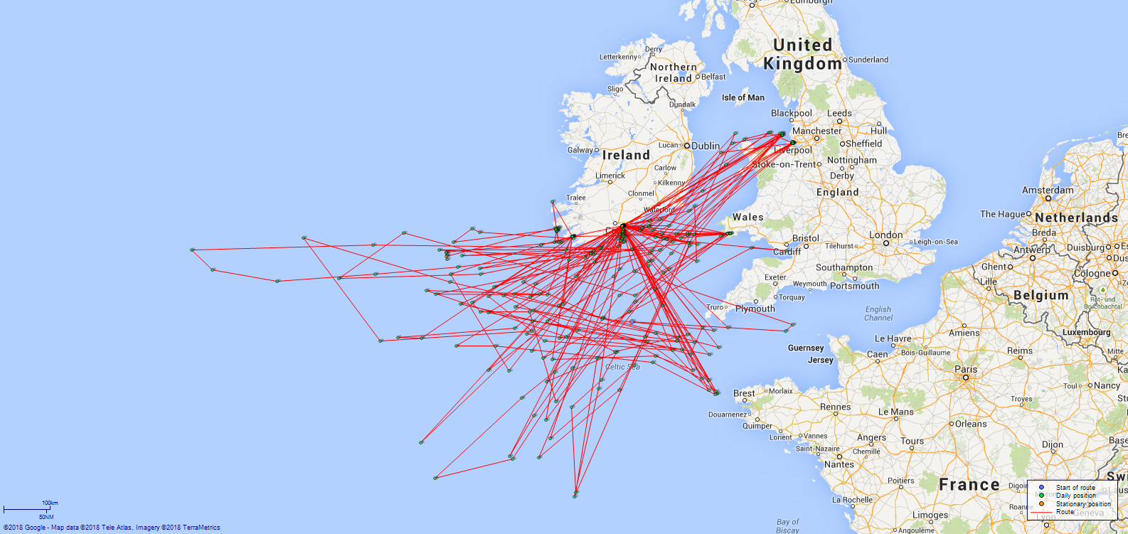
LOGS FOR SEPTEMBER 1917 4ef4f922e53e0a0c910049fb: (https://s3.amazonaws.com:443/oldweather/ADM53-45362/ADM 53-45362-177_1.jpg) [Cover of Copy of Log for September 1917, signed by Navigating Officer, as before] 4ef4f922e53e0a0c910049fc: (https://s3.amazonaws.com:443/oldweather/ADM53-45362/ADM 53-45362-178_0.jpg) [Blank page] 4ef4f922e53e0a0c910049fd: (https://s3.amazonaws.com:443/oldweather/ADM53-45362/ADM 53-45362-178_1.jpg) [Page not filled in] 4ef4f922e53e0a0c910049fe: (https://s3.amazonaws.com:443/oldweather/ADM53-45362/ADM 53-45362-179_0.jpg) [Details of Barometer and Thermometers, as before] 4ef4f922e53e0a0c910049ff: (https://s3.amazonaws.com:443/oldweather/ADM53-45362/ADM 53-45362-179_1.jpg) 1 September 1917 At Queenstown Lat 51.85, Long -8.28 [estimated] [At No 1 buoy Queenstown] 7.0am: Liberty men returned on board. am: Hands employed washing paintwork and cleaning ship. 10.15am: USS Drayton came alongside and secured forward to buoy. 11.15am: Hands to quarters and clean guns. 0.30pm: 1 Steward rating joined ship. 1.10pm: Hands paid monthly payment. pm: Hands employed painting. 4.45pm: Liberty men landed. 6.15pm: Patrol landed. 11.15pm: Patrol returned on board. [Provisions received: Fresh Meat 334 lbs, Vegetables 600 lbs, Bread 411 lbs] [Note: USS “Drayton” (DD-23) was an American Paulding class destroyer built in 1910; she arrived in Queenstown on 1 June 1917, transferred to Brest, France, in February 1918 and returned to the USA in early 1919; she was decommissioned in November 1919 and was sold in 1935 (more details here).] 4ef4f922e53e0a0c91004a00: (https://s3.amazonaws.com:443/oldweather/ADM53-45362/ADM 53-45362-180_0.jpg) 2 September 1917 At Queenstown Lat 51.85, Long -8.28 [At No 1 buoy Queenstown] 7.0am: Liberty men returned on board. 9.40am: RC church party landed. 10.15am: C of E church party landed. 11.30am: All church parties returned on board. 1.0pm: Liberty men landed. 4.30pm: Liberty men landed. 6.15pm: Patrol landed. 7.0pm: Boys returned on board. 9.0pm: Liberty men returned on board. 10.0pm: POs returned on board. 11.0pm: Patrol returned on board. 4ef4f923e53e0a0c91004a01: (https://s3.amazonaws.com:443/oldweather/ADM53-45362/ADM 53-45362-180_1.jpg) 3 September 1917 At Queenstown, Sea Lat 51.43, Long -8.95 8.37am: Slipped from buoy, revs 100. [Draught leaving: 10ft 2in fore; 12ft 8in aft] 9.0am: Passed through boom defence gates, revs 120. 9.13am: Roche's Point abeam, course S12W, all clocks to GMT. 8.15am [after clock change]: Stopped to clear hand lead. 9.17am [8.17am]: Proceeded ahead, revs 120. 8.40am: Daunt Light Vessel bearing West, streamed log, altered course S39W. 9.4am: Daunt Light Vessel bearing N19E 5 miles, altered course S68W, commenced ZZ. am: Hands employed refilling boats’ barricoes, painting motor boat, painting ship and refitting as required. 11.10am: Old Head of Kinsale bearing North 6 miles, altered course N89W. 1.16pm: Altered course S32W, revs 150 to close SS “Grampian” [listed here]. 2.10pm: Fastnet bearing N19E 6 miles, altered course S88E. 3.50pm: Altered course S85E, revs 150 to intercept SS Tortuguero. 3.59pm: Altered course N89W to escort SS Tortuguero. 5.50pm: Fastnet bearing N19E 5 miles, altered course S85E, revs 140. 10.0pm: Old Head of Kinsale bearing North 6 miles, altered course N89W. [Course and Distance made good: Various 43.5 miles] [True Bearing and Distance: Galley Head Light House bearing 3 degrees, distant 6 miles] [Fuel Remaining: Coal 231 tons] [Note: SS “Grampian” was a British passenger/cargo ship built in Scotland in 1907 for Allan Line Steamships Company, Glasgow; in 1917 she transferred to Canadian Pacific Ocean Services; she burned out during a refit at Antwerp and was sold for breaking in The Netherlands in 1925 (more details here). For details of SS “Tortuguero” see 23 May 1916.] 4ef4f923e53e0a0c91004a02: (https://s3.amazonaws.com:443/oldweather/ADM53-45362/ADM 53-45362-181_0.jpg) 4 September 1917 At Sea, Queenstown Lat 51.52, Long -8.53 1.58am: Fastnet bearing North, altered course S88E. 2.30am: Fastnet bearing N19E 6 miles, altered course S88E. 4.25am: Fastnet bearing N19E, altered course S88E. 5.0am: Escorting SS Elotia [probably Etolia] S85E. 10.0am: Old Head of Kinsale bearing North 8 miles, altered course N89W. am: Hands employed painting and cleaning motor boat, battery doors, accommodation ladder, scraping decks, refitting and as required. 0.15pm: Old Head of Kinsale bearing North 6 miles, altered course N70E. 1.25pm: Daunt Light Vessel bearing N19E 5 miles, altered course N25E. 2.15pm: Daunt Light Vessel bearing West, Log in 20.9. 2.30pm: Roche's Point abeam, all clocks to BST. 3.50pm [after clock change]: Passed through boom defence gates, revs 100. 4.30pm: Secured alongside collier Grantly [Grantley]. [Alongside collier Grantly Queenstown] 5.30pm: Commenced coaling. 6.40pm: Finished coaling received 30 tons. 9.0pm: Liberty men landed. [Course and Distance made good: Various 233 miles] [True Bearing and Distance: Old Head of Kinsale bearing 3 degrees, distant 5.5 miles] [Fuel Remaining: Coal 250 tons] [Note: For details of SS “Etolia” see 28 April 1917 in this log. For details of SS “Grantley” see 31 August 1917 in this log.] 4ef4f923e53e0a0c91004a03: (https://s3.amazonaws.com:443/oldweather/ADM53-45362/ADM 53-45362-181_1.jpg) 5 September 1917 At Queenstown Lat 51.85, Long -8.28 [estimated] [Alongside collier Grantley Queenstown] 7.15am: Liberty men returned onboard. am: Hands employed painting ship and drawing stores. 11.30am: Hands to quarters and clean guns. pm: Hands employed painting ship. 4.30pm: Liberty men landed. 6.15pm: Patrol landed. 10.30pm: Liberty men returned on board. 11.30pm: Patrol returned on board. [Course and Distance made good: Various 18.7 miles] 4ef4f923e53e0a0c91004a04: (https://s3.amazonaws.com:443/oldweather/ADM53-45362/ADM 53-45362-182_0.jpg) 6 September 1917 At Queenstown and Sea Lat 51.85, Long -8.28 [Alongside collier Grantley Queenstown] am: Hands employed painting and drawing stores. 11.30am: Hands to quarters and clean guns. 1.15pm: Hands mustered for sale of dead seamen’s effects. 3.0pm: Hands to make and mend. 5.23pm: Slipped from collier and came [?] astern. 5.30pm: Secured forward to quarter of collier whilst hoisting first whaler and motor boat. 5.50pm: Slipped from collier, proceeded ahead revs 150. 6.20pm: Passed through boom defence gates, revs 120. 6.30pm: All clocks to GMT. 5.35pm [after clock change]: Roche's Point abeam, set course S5W. 6.7pm: Daunt Light Vessel bearing West true 0.5 miles, streamed log. 6.15pm: Daunt Light Vessel bearing N20W 1.5 miles, altered course S27W. 6.45pm: Daunt Light Vessel bearing North true 5 miles, altered course S3W. [Provisions received: Fresh Meat 236 lbs, Vegetables 360 lbs, Bread 200 lbs] 4ef4f923e53e0a0c91004a05: (https://s3.amazonaws.com:443/oldweather/ADM53-45362/ADM 53-45362-182_1.jpg) 7 September 1917 At Sea Lat 49.98, Long -7.97 8.35am: Altered course various to intercept convoy. 9.0m: Revs 140, course S71E escorting convoy. am: Hands employed painting batteries, foremost guns, refitting and as required. 2.0pm: Escorting convoy. 4.10pm: Exercise fire stations in stoker POs room. 6.0pm: Escorting convoy. 8.27pm: Ceased ZZ, took station on starboard quarter of leading ship of starboard column, revolutions as required for keeping station. [Course and Distance made good: Various 205 miles] [True Bearing and Distance: Bishop Rock Light House bearing 96 degrees, distant 59 miles] 4ef4f923e53e0a0c91004a06: (https://s3.amazonaws.com:443/oldweather/ADM53-45362/ADM 53-45362-183_0.jpg) 8 September 1917 At Sea Lat 49.80, Long -3.22 2.0am: Escorting convoy. 2.20am: Revs 110, commenced ZZ. 6.0am and 10.30am: Escorting convoy. 2.0pm and 6.0pm: Escorting convoy. 9.0pm: Rounds correct. Took station in line ahead, revs as required for keeping station. 10.45pm: Course and speed as required for entering swept channel. [Distance run through the Water: 262 miles] [Course and Distance made good: Various 207 miles] [True Bearing and Distance: Start Point Light House bearing 328 degrees, distant 30 miles] [Weather mostly fine and quiet, noon temperature 68F, sea temperature 61F] 4ef4f923e53e0a0c91004a07: (https://s3.amazonaws.com:443/oldweather/ADM53-45362/ADM 53-45362-183_1.jpg) 9 September 1917 At Sea Lat 49.93, Long -3.00 Midnight: Log in. 1.0am: Parted company with convoy off St Helens, altered course to sea. 2.50am: St Catherine’s Light bearing N27W 4 miles, altered course S66E. 10.15am: Altered course S39W in the direction of gunfire, revs 150. 10.30am: Closed HMS Mysotis [Myosotis] which had been torpedoed and commenced acting as screen whilst HMS Bluebell picked up survivors. 11.10am: In log, revs 150. Noon: Streamed log. 1.20pm: HMS Bluebell commenced towing HMS Mysotis [sic] escorted by HMS Jessamine and HMS Camellia. 3.10pm: Trawler and tug assisting in escorting. 5.0pm: Torpedo destroyers joined escort. 6.0pm: Turned over escort to destroyers, altered course S83W, revs 140. 9.20pm: Revs 120, ceased ZZ. 11.0pm: Lizard Light bearing North 15 miles, altered course N80W. [Distance run through the Water: 255 miles] [Course and Distance made good: Various 204 miles] [True Bearing and Distance: Start Point Light House bearing 208 degrees, distant 30 miles] [Fuel Remaining: Coal 177 tons] [Note: Reference to torpedoing of HMS Myosotis here. Entry on Casualty List for this date reads: Myosotis, fleet sweeping sloop, torpedoed and damaged by UC.71 in English Channel. DAVIS, George W, Leading Seaman, J 16718 (Ch), FOX, Arthur R S, Officer's Steward 2c, L 6289 (Ch), GADD, William, Ordinary Seaman, J 38817 (Ch)] 4ef4f923e53e0a0c91004a08: (https://s3.amazonaws.com:443/oldweather/ADM53-45362/ADM 53-45362-184_0.jpg) 10 September 1917 At Sea and Queenstown Lat 50.97, Long -7.90 3.30am: Revs 140, commenced ZZ. 3.40am: Bishop Rock Light bearing N17E distant 14.5 [miles], altered course N47W. 4.40am: Bishop Rock Light bearing N65E 15 miles, altered course N10W. am: Hands employed cleaning out motor boat, second whaler, second dinghy, painting foremost gun and as required. 3.45pm: Daunt Light Vessel bearing West magnetic 4 cables. altered course N30E, Log in. 4.5pm: Roche's Point abeam. 4.25pm: Passed through boom defence gates. 5.15pm: Secured alongside collier Uskside assisted by tug Hellespont. [Alongside collier Uskside Queenstown] 7.30pm: Commenced coaling. 9.0pm: Hands employed coaling ship. 11.45pm: Finished coaling, received 90 tons. [Course and Distance made good: Various 243 miles] [True Bearing and Distance: Daunt Rock Light Vessel bearing 243 degrees, distant 48.5 miles] [Fuel Remaining: Coal 250 tons] [Note: SS “Uskside” was a British cargo ship built in Sunderland in 1913 for Uskside Steamship Company, Newport; she was requisitioned by the Admiralty as an RFA auxiliary from August 1914 to January 1919; in 1918 she was owned by Pelton Steamship Company, Newcastle, and was renamed “Largo”; in 1946 she went to a Chinese company in Shanghai and became “Foo Nan”; she went to a company in Taiwan in 1951 and was renamed “Kwang Hua”; she was deleted from the registers in 1956.] 4ef4f923e53e0a0c91004a09: (https://s3.amazonaws.com:443/oldweather/ADM53-45362/ADM 53-45362-184_1.jpg) 11 September 1917 At Queenstown Lat 51.85, Long -8.28 [estimated] [Alongside collier Uskside Queenstown] am: Hands employed scrubbing deck and cleaning ship. pm: Hands to make and mend. 5 Seamen and 1 signal rating joined ship. 3 Seamen and 1 signal rating discharged from ship. 4.30pm: 2 Seamen ratings discharged from ship. [Course and Distance made good: Various 47.5 miles] [Provisions received: Fresh Meat 112 and 278 lbs, Vegetables 240 and 560 lbs, Bread 160 and 360 lbs] 4ef4f923e53e0a0c91004a0a: (https://s3.amazonaws.com:443/oldweather/ADM53-45362/ADM 53-45362-185_0.jpg) 12 September 1917 Queenstown Lat 51.85, Long -8.28 [estimated] [Alongside collier “Uskside” Queenstown] 8.15am: Hands to quarters and clean guns. 9.20am: Slipped from collier and proceeded towards No 3 buoy assisted by tug Hellespont. 10.15am: Secured forward to No 3 buoy. Hands employed painting and as required. [At No 3 buoy Queenstown] 1.30pm: Liberty men landed. pm: Hands employed painting ship. 4.30pm: Liberty men landed. 6.30pm: Patrol landed. 9.0pm: Liberty men returned on board. 11.20pm: Patrol returned on board. 4ef4f923e53e0a0c91004a0b: (https://s3.amazonaws.com:443/oldweather/ADM53-45362/ADM 53-45362-185_1.jpg) 13 September 1917 At Queenstown and sea and Milford Haven Lat 51.97, Long -7.13 [At No 3 buoy Queenstown] 6.5am: Slipped from buoy and proceeded to turn around, revs various. 6.15am: Turned around and proceeded towards harbour entrance. 6.35am: Passed through boom defence gates. 6.45am: Roche's Point abeam, set course S12W, clocks to GMT. 6.12am [after clock change]: Daunt Light Vessel bearing West 0.5 miles, altered course S19W, streamed log. 7.0am: Altered course S73E escorting oiler. am: Hands employed painting, refitting and as required. 2.0pm: Escorting oiler. 4.35pm: Revs various to signal oiler. 5.50pm and 6.0pm: Revs various to signal oiler. 6.30pm: Bishop Rock Light bearing N40E 3 miles, altered course S66E, revs 150. 7.0pm: Log in 77.4. 8.10pm: Castle Head Lights in line, altered course N57E. 8.35pm: Came to on starboard anchor 4 shackles, 10 fathoms. [At anchor in Dale Roads Milford Haven] [Anchor bearings: St Annes [Anns] Head Light bearing S69W; Castle Head high light N62E] [Course and Distance made good: Various 54 miles] [True Bearing and Distance: Mine Head bearing 318 degrees, distant 26 miles] [Misty for most of day sea rough from noon; noon temperature 58F, sea temperature 59F] 4ef4f923e53e0a0c91004a0c: (https://s3.amazonaws.com:443/oldweather/ADM53-45362/ADM 53-45362-186_0.jpg) 14 September 1917 At Milford Haven Lat 51.70, Long -5.04 [estimated] [At anchor in Dale Roads Milford Haven] 6.45am: Weighed anchor and proceeded up harbour. 7.20am: Came to on starboard anchor 3 shackles, 10.5 fathoms water. [At anchor off Milford docks. Anchor bearings: St Catherine’s Church N6E, No 5 buoy S66E] am: Hands employed painting, scraping, refitting and as required. 2.45pm: Weighed anchor and proceeded towards Dale Roads. 3.5pm: Came to on starboard anchor 2 shackles. [At anchor in Dale Roads Milford Haven] 4.5pm: Weighed anchor and proceeded out of harbour at head of convoy. 4.24pm: St Annes [Anns] Head bearing N10W, altered course S58W, speed various. 6.0pm: Took station on starboard side of convoy, revs 120, course S67W. 8.0pm: Ceased ZZ, speed as required for keeping station. 10.0pm: Escorting convoy. [Course and Distance made good: Various 92 miles] 4ef4f923e53e0a0c91004a0d: (https://s3.amazonaws.com:443/oldweather/ADM53-45362/ADM 53-45362-186_1.jpg) 15 September 1917 At Sea Lat 50.18, Long -8.07 2.0am: Escorting convoy. 5.0am: Revs 120, commenced ZZ. 6.30am: Speed various to signal convoy. 8.15am: Action stations, course and speed various. 8.20am: Commenced firing at object on surface. 8.30am: Closed submerged derelict. 8.35am: Resumed original ZZ course, cease fire. 1.30pm: Escorting convoy. 3.20pm: Came on foggy, ceased ZZ. 4.57pm: Came on foggy, revs 80, ceased ZZ. 5.20pm: Fog lifted, revs 120, continued ZZ. 5.33pm: Came on foggy, revs 80, ceased ZZ. 5.55pm: Fog lifted, revs 120, continued ZZ. 6.15pm: Came on foggy, revs 80, ceased ZZ. 6.30pm: Fog lifted, revs 100, continued ZZ. 7.30pm: Revs 86, took station on starboard side of convoy, ceased ZZ, altered course S70W. 10.0pm: Escorting convoy. [Distance run through the Water: 287 miles] [Course and Distance made good: Various 150 miles] [True Bearing and Distance: Bishop Rock bearing 105 degrees, distant 66 miles] 4ef4f923e53e0a0c91004a0e: (https://s3.amazonaws.com:443/oldweather/ADM53-45362/ADM 53-45362-187_0.jpg) 16 September 1917 At Sea Lat 48.44, Long -11.38 2.0am: Escorting convoy. 5.40am: Revs 120, commenced ZZ. 6.0am and 9.30am: Escorting convoy. 10.30am: Divisions, rounds, and divine service. 2.30pm: Escorting convoy. 9.45pm: Courses and speed various to avoid another convoy steering to NE. 10.0pm: Took station on own convoy, revs 84. [Course and Distance made good: Various 168 miles] [True Bearing and Distance: Bishop Rock bearing 65 degrees, distant 208 miles] 4ef4f923e53e0a0c91004a0f: (https://s3.amazonaws.com:443/oldweather/ADM53-45362/ADM 53-45362-187_1.jpg) 17 September 1917 At Sea Lat 46.77, Long -14.07 2.0am: Escorting convoy. 4.0am: Convoy dispersed. 5.45am: Revs 100, commenced ZZ. 7.0am: Arrived at rendezvous, commenced circling around awaiting trawlers. 7.45am: Continued on course S65W, trawlers in single line ahead. 9.10am: Fore guns crew to drill. 6.0pm: Revs various to signal trawler. 7.30pm: Revs 80 to take station on port bow of leading trawler. 10.0pm: Revs various for keeping station. [Distance run through the Water: 208 miles] [Course and Distance made good: Various 146 miles] [True Bearing and Distance: Ushant bearing 74 degrees, distant 385 miles] 4ef4f924e53e0a0c91004a10: (https://s3.amazonaws.com:443/oldweather/ADM53-45362/ADM 53-45362-188_0.jpg) 18 September 1917 At Sea Lat 47.17, Long -11.67 7.0am: Revs 150, trawlers disposed in single line ahead to starboard, altered course S87W looking for convoy. 7.40am: Convoy sighted, altered course S45E, revs 160. 7.50am: Course various signalling trawlers. 9.15am: Took station ZZ ahead of convoy, revs 130, course N49E. 2.0pm and 6.0pm: Escorting convoy. 7.15pm: Took station ahead of convoy, ceased ZZ, revs 78. 10.0pm: Escorting convoy. [Distance run through the Water: 223 miles] [Course and Distance made good: Various 175 miles] [True Bearing and Distance: Bishop Rock bearing 52 degrees, distant 260 miles] 4ef4f924e53e0a0c91004a11: (https://s3.amazonaws.com:443/oldweather/ADM53-45362/ADM 53-45362-188_1.jpg) 19 September 1917 At Sea Lat 49.05, Long -9.83 2.0am: Escorting convoy. 6.0am: Revs 120, altered course S47W to take station on convoy. 7.0am: Took station ahead ZZ of convoy. 9.30am: Speed and course various to signal Commodore ship. 11.50am: Resumed station ahead of convoy ZZ, revs 120. 7.50pm: Revs various for taking station. 8.30pm: In station ahead of convoy, revs 74. [Distance run through the Water: 207 miles] [Course and Distance made good: Various 144 miles] [True Bearing and Distance: Bishop Rock bearing 70 degrees, distant 140 miles] 4ef4f924e53e0a0c91004a12: (https://s3.amazonaws.com:443/oldweather/ADM53-45362/ADM 53-45362-189_0.jpg) 20 September 1917 At Sea Lat 51.01, Long -6.83 5.30am: Revs 100, commenced ZZ. 5.0pm: Altered course N58E, revs 80, ceased ZZ, took station ahead of convoy. 7.15pm: Revs various for taking station astern of convoy. 7.30pm: Revs 70, took station astern of convoy, course N50E. 9.4pm: Bishop Rock Light bearing East (magnetic), altered course N74W, revs 120. [Course and Distance made good: Various 165 miles] [True Bearing and Distance: Smalls Light House bearing 41 degrees, distant 61 miles] [Fuel Remaining: Coal 119 tons] [South westerly wind force 5 to 6 for most of day, with rough or very rough sea] 4ef4f924e53e0a0c91004a13: (https://s3.amazonaws.com:443/oldweather/ADM53-45362/ADM 53-45362-189_1.jpg) 21 September 1917 At Sea, Queenstown Lat 51.85, Long -8.28 [estimated] Midnight: Coningbeg Light Vessel bearing N3E. 2.7am: Mine Head Light bearing N89W. 3.44am: Mine Head Light bearing N2W (true) 19.5 miles. 4.0am: Mine Head Light bearing N2E (true). 5.35am: Daunt Light Vessel bearing N25W, altered course N21W. 6.10am: Daunt Light Vessel bearing West 0.5 miles, altered course N10E, Log in 184.9. 6.30am: Roche's Point abeam. 6.50am: Passed through boom defence gates. 7.15am: Secured forward to No 1 buoy. [At No 1 buoy Queenstown] 8.5am: Coal lighter arrived alongside with Temperley transporter. 9.15am: Commenced coaling. am and pm: Hands employed coaling. 3.0pm: Finished coaling, received 138 tons. Hands employed scrubbing decks. 5.30pm: Liberty men landed. 6.20pm: Patrol and liberty men landed. 11.15am: Patrol returned on board. [Course and Distance made good: Various 167 miles] [Provisions received: Fresh Meat 89 lbs, Vegetables 360 lbs, Bread 160 lbs] [Fuel Remaining: Coal 249 tons] 4ef4f924e53e0a0c91004a14: (https://s3.amazonaws.com:443/oldweather/ADM53-45362/ADM 53-45362-190_0.jpg) 22 September 1917 At Queenstown Lat 51.85, Long -8.28 [At No 1 buoy Queenstown] 7.15am: Liberty men returned on board. am: Hands employed cleaning ship and drawing stores. 11.15am: Hands to quarters and clean guns. pm: Hands employed stowing provisions. 3.0pm: Liberty men landed. 3 ratings discharged to hospital. 1 rating discharged to HMS Colleen. 5.0pm: Liberty men landed. 6.15pm: Patrol and liberty men landed. 10.10pm: Liberty men returned on board. 11.15pm: Patrol returned on board. [Provisions received: Fresh Meat 302 lbs, Vegetables 360 lbs, Bread 360 lbs] 4ef4f924e53e0a0c91004a15: (https://s3.amazonaws.com:443/oldweather/ADM53-45362/ADM 53-45362-190_1.jpg) 23 September 1917 At Queenstown Lat 51.85, Long -8.28 [At No 1 buoy Queenstown] 7.15am: Liberty men returned on board. 9.30am: RC church party landed. 10.30am: RC church party returned on board. 11.0am: Church of England party landed. 1.10pm: Church of England party returned on board. 2.0pm: Liberty men landed. 6.0pm: Patrol and liberty men landed. 7.0pm: Boys returned on board. 9.10pm: Liberty men returned on board. 11.15pm: Patrol returned on board. 4ef4f924e53e0a0c91004a16: (https://s3.amazonaws.com:443/oldweather/ADM53-45362/ADM 53-45362-191_0.jpg) 24 September 1917 At Queenstown Lat 51.85, Long -8.28 [At No 1 buoy Queenstown] am and pm: Hands employed painting ship. 6.0pm: Prisoner discharged to HMS Colleen. [Provisions received: Fresh Meat 51 lbs, Bread 50 lbs] 4ef4f924e53e0a0c91004a17: (https://s3.amazonaws.com:443/oldweather/ADM53-45362/ADM 53-45362-191_1.jpg) 25 September 1917 At Queenstown Lat 51.85, Long -8.28 [At No 1 buoy Queenstown] am: Hands employed oiling wires and drawing stores and painting. pm: Hands employed drawing stores and painting. [Provisions received: Fresh Meat 56 lbs] 4ef4f924e53e0a0c91004a18: (https://s3.amazonaws.com:443/oldweather/ADM53-45362/ADM 53-45362-192_0.jpg) 26 September 1917 At Queenstown, sea Lat 51.46, Long -8.40 [At No 1 buoy Queenstown] [Draught leaving: 10ft 2in fore; 12ft 10in aft] 7.0am: Hands employed scrubbing decks and preparing ship for sea. 8.30am: Slipped from No 1 buoy, speed various for turning around. 8.35am: Proceeded ahead. 8.50am: Passed through boom defence gate. 9.5am: Roche's Point abeam, escorting SS Albiston [Albistan, listed here], set course S6W. 9.40am: Daunt Light Vessel bearing West, streamed log, altered course S15W. 10.0am: Revs 120, commenced ZZ. 2.0pm: Escorting SS Albistan with HMS Bluebell. 6.0pm: Escorting SS Albistan. 10.0pm: Escorting SS Albistan with HMS Bluebell. [Course and Distance made good: Various 26.5 miles] [True Bearing and Distance: Old Head of Kinsale bearing 331 degrees, distant 10.3 miles] [Note: SS “Albistan” was a British cargo ship built as “Cambyses” in 1905 in West Hartlepool for Gladstone & Company, West Hartlepool; in 1912 she went to Anglo-Algerian Steamship Company, Swansea, and was renamed “Albistan”; in 1913 she went to Strick Line and in 1919 was owned by Pentaff Steamship Company, Cardiff, and in 1920 by Venco Steamship Company, London; in 1921 she went to a Danish company in Copenhagen; in 1924 she went to another Danish company and was renamed “Dublin”; in 1925 she went to Britain Steamship Company, London, and became “Fulham”; in 1934 she went to Delta Steamship Company, London, and became “Farnham”; in 1936 she went to an Italian company and became “Apollo”; in 1943 she was scuttled in Italy, was refloated and repaired in 1944 and went to another Italian company in 1948; she was broken up in Italy in 1962 (more details here).] 4ef4f924e53e0a0c91004a19: (https://s3.amazonaws.com:443/oldweather/ADM53-45362/ADM 53-45362-192_1.jpg) 27 September 1917 At Sea Lat 50.92, Long -12.65 1.25am: Revs 96, ceased ZZ, took station on starboard bow of convoy. 2.0am and 6.30am: Escorting SS Albistan with HMS Bluebell. 5.40am: Revs 120, commenced ZZ. am: Hands employed laying mat at after gun, painting in first whaler, washing boat’s davits, oiling over spare blocks and shackles, painting aft and as required. 2.0pm, 6.0pm and 10.0pm: Escorting SS Albistan with HMS Bluebell. 4.30pm: Exercise fire in carpenter’s lower store room. [Distance run through the Water: 246 miles] [Course and Distance made good: Various 172 miles] [True Bearing and Distance: Great Skellig Island bearing 57 degrees, distant 93 miles] 4ef4f924e53e0a0c91004a1a: (https://s3.amazonaws.com:443/oldweather/ADM53-45362/ADM 53-45362-193_0.jpg) 28 September 1917 At Sea Lat 50.83, Long -17.02 2.0am: Revs 98, ceased ZZ, took station on starboard bow of convoy. 3.0am and 5.30am: Escorting SS Albistan. 6.15am: Revs 120, commenced ZZ. am: Hands to drill at loader. Hands employed oiling over shells, scrubbing first whaler gear, cleaning ship, refitting and as required. 11.30am: Altered course N22E, parted company with convoy. 4.5pm: Altered course various for firing practice. 4.35pm: Dropped target. 4.45pm: Commenced firing from 3 pounder and after 4 inch gun. 5.50pm: Cease fire. 6.5pm: In target, set course N68W, revs 110. 6.15pm: Altered course N22E, commenced ZZ. [Distance run through the Water: 244 miles] [Course and Distance made good: 268 degrees, 174 miles] [True Bearing and Distance: Great Skellig Island bearing 77 degrees, distant 260 miles] 4ef4f924e53e0a0c91004a1b: (https://s3.amazonaws.com:443/oldweather/ADM53-45362/ADM 53-45362-193_1.jpg) 29 September 1917 At Sea Lat 51.71, Long -15.03 3.25am: Revs 100, ceased ZZ. 6.0am: Revs 110, commenced ZZ. 7.15am: Circling around. 7.40am: Altered course N76W, revs 150 to intercept SS Khyber [Khyber (1) listed here]. 8.15am: Altered course S53E, escorting SS Khyber with HMS Bluebell, revs 150. 2.0pm and 9.30pm: Escorting SS Khyber with HMS Bluebell. [Course and Distance made good: Various 221 miles] [True Bearing and Distance: Great Skellig Island bearing 69 degrees, distant 185 miles. [Note: SS “Khyber” (pictured here) was a passenger/cargo ship built in Birkenhead in 1914 for Peninsular & Oriental Steam Navigation Company, London; she was scrapped in Japan in 1931.] 4ef4f925e53e0a0c91004a1c: (https://s3.amazonaws.com:443/oldweather/ADM53-45362/ADM 53-45362-194_0.jpg) 30 September 1917 At Sea Lat 50.50, Long -7.88 2.0am, 6.0am and 9.30am: Escorting SS Khyber with HMS Bluebell. 10.30am: Divisions, rounds and Divine service. 2.0pm: Escorting SS Khyber with HMS Bluebell. 6.40pm: Seven Stones Light Vessel bearing S5W 3 miles, altered course N39E, revs 110. Parted company with SS Khyber. [Distance run through the Water: 322 miles] [Course and Distance made good: 106 degrees, 284 miles] [True Bearing and Distance: Bishop Rock bearing 124 degrees, distant 67 miles] [Fuel Remaining: Coal 133 tons] LOGS FOR OCTOBER 1917 4ef4f925e53e0a0c91004a1d: (https://s3.amazonaws.com:443/oldweather/ADM53-45362/ADM 53-45362-194_1.jpg) [Cover of Copy of Log for October 1917, signed by Navigating Officer, as before] 4ef4f925e53e0a0c91004a1e: (https://s3.amazonaws.com:443/oldweather/ADM53-45362/ADM 53-45362-195_0.jpg) [Blank page] 4ef4f925e53e0a0c91004a1f: (https://s3.amazonaws.com:443/oldweather/ADM53-45362/ADM 53-45362-195_1.jpg) [Page not filled in] 4ef4f925e53e0a0c91004a20: (https://s3.amazonaws.com:443/oldweather/ADM53-45362/ADM 53-45362-196_0.jpg) [Details of Barometer and Thermometers, as before] 4ef4f925e53e0a0c91004a21: (https://s3.amazonaws.com:443/oldweather/ADM53-45362/ADM 53-45362-196_1.jpg) 1 October 1917 At Sea and Milford Haven Lat 51.70, Long -4.95 [estimated] 5.0am: Log in, revs 80. 5.30am: St Annes [Anns] Head Light abeam, altered course for leading lights. 6.5am: Came to on port anchor 2 shackles, 13 fathoms water. [At anchor off Milford Docks. Anchor bearings: St Catherine's Church N59E; No 4 Checqured [chequered] buoy N72W] 7.25am: Weighed anchor and proceeded towards Pembroke Dock. 7.40am: Came to on port anchor 3 shackles, 10 fathoms water. [At anchor off Pembroke Docks] 8.30am: Coal lighters arrived alongside. 8.45am: Commenced coaling. am: Hands employed coaling. 1.50pm: Finished coaling, received 125 tons. 5.0pm: Liberty men landed. 6.30pm: Patrol and Liberty men landed. 9.0pm: Liberty men returned on board. 10.15pm: Patrol and liberty men returned on board. [Provisions received: Fresh Meat 320 lbs, Vegetables 700 lbs, Bread 400 lbs] [Fuel Remaining: Coal 250 tons] 4ef4f925e53e0a0c91004a22: (https://s3.amazonaws.com:443/oldweather/ADM53-45362/ADM 53-45362-197_0.jpg) 2 October 1917 At Milford Haven Lat 51.70, Long -5.04 [estimated] [At anchor off Pembroke Dock] 7.15am: Liberty men returned on board. 9.20am: Weighed anchor and proceeded towards Milford. 10.35am: Came to on port anchor 3 shackles, 13 fathoms water. [At anchor off Milford Haven Docks. Anchor bearings: St Catherine’s Church N42E, No 4 checqured [sic] buoy N68W] 1.30pm: Liberty men landed. pm: Hands to make and mend. 6.30pm: Patrol and liberty men landed. 10.15pm: Patrol and liberty men returned on board. [Course and Distance made good: 7 miles] 4ef4f925e53e0a0c91004a23: (https://s3.amazonaws.com:443/oldweather/ADM53-45362/ADM 53-45362-197_1.jpg) 3 October 1917 At Milford Haven [and Sea] Lat 51.70, Long -5.04 [At anchor off Milford Haven Docks] am: Hands employed washing paintwork. 11.30am: Hands to quarters and clean guns. [Draught leaving: 10ft fore; 12ft 8in aft] 1.0pm: Hands employed preparing ship for sea. 2.30pm: Weighed anchor and proceeded towards harbour entrance. 2.50pm: Passed through boom defence gates. 3.55pm: St Annes Head abeam 0.5 miles, altered course S57W, proceeded out of harbour [?] entrance, convoy of 20 ships [?] by HMS Bluebell [?] trawlers. 4.10pm: Streamed log. 7.0pm: Took station on starboard side of convoy, revs 70. 10.0pm: Smalls Light bearing N24W. 11.0pm: Smalls Light bearing N7E. 4ef4f925e53e0a0c91004a24: (https://s3.amazonaws.com:443/oldweather/ADM53-45362/ADM 53-45362-198_0.jpg) 4 October 1917 At Sea Lat 50.95, Long -7.00 1.15am: Smalls Light bearing N47E. 2.0am and 6.0am: Escorting convoy with HMS Bluebell and 10 trawlers. 11.27am: Took station on starboard side of convoy, revs 80. 2.0pm and 6.0pm: Escorting convoy with HMS Bluebell and 10 trawlers. 7.0pm: Took station on starboard side of convoy, revs 75, course S86W. 8.25pm: Revs 110, commenced ZZ. [Course and Distance made good: 88 miles] [True Bearing and Distance: Bishop Rock bearing 163 degrees, distant 67 miles] [North westerly wind force 5 from noon, with rough sea; rain or showers in am, fine weather in pm; noon temperature 60F, sea temperature 59F] 4ef4f925e53e0a0c91004a25: (https://s3.amazonaws.com:443/oldweather/ADM53-45362/ADM 53-45362-198_1.jpg) 5 October 1917 At Sea Lat 49.26, Long -9.05 2.0am: Revs 80, ceased ZZ. 3.0am, 6.0am and 8.30am: Escorting convoy with HMS Bluebell and 10 trawlers. 6.0am: Revs 120, commenced ZZ. am: Hands employed refilling boats breakers [barricoes], washing paintwork, refitting and as required. 2.0pm and 4.30pm: Escorting convoy with HMS Bluebell and 10 trawlers. 7.15pm: Took station on starboard side of convoy, ceased ZZ, course S40W, revs 70. 10.30pm: Escorting convoy with HMS Bluebell and 10 trawlers. 10.50pm: Revs 110, commenced ZZ. [Distance run through the Water: 184 miles] [Course and Distance made good: Various 138 miles] [True Bearing and Distance: Bishop Rock bearing 71 degrees, distant 107 miles] [Wind north westerly all day; force 7 with very rough sea at 4am; wind and sea then reducing slightly] 4ef4f925e53e0a0c91004a26: (https://s3.amazonaws.com:443/oldweather/ADM53-45362/ADM 53-45362-199_0.jpg) 6 October 1917 At Sea Lat 46.47, Long -9.72 2.0am, 5.0am, 9.30am and 2.0pm: Escorting convoy with HMS Bluebell and 10 trawlers. 7.0pm: Signal to disperse convoy. 7.10pm: Took station astern of convoy. 7.20pm: Stopped to repair steering gear. 7.35pm: Proceeded ahead, revs 120, S32W. 8.55pm: Altered course N17E, revs 120, parted with convoy. 11.40pm: Commenced ZZ. [Course and Distance made good: 188 degrees, 170 miles] [True Bearing and Distance: Ushant bearing 57 degrees, distant 219 miles] [Sea rough until 8am] 4ef4f925e53e0a0c91004a27: (https://s3.amazonaws.com:443/oldweather/ADM53-45362/ADM 53-45362-199_1.jpg) 7 October 1917 At Sea Lat 48.25, Long -9.85 10.15am: Divisions, rounds, and Divine service. 7.30pm: Revs 90, ceased ZZ. 11.40pm: Revs 120, commenced ZZ. [Course and Distance made good: Various 233 miles] [True Bearing and Distance: Bishop Rock bearing 53 degrees, distant 170 miles] [North westerly wind force 6 or 5 from noon onwards, with very rough or rough sea] 4ef4f925e53e0a0c91004a28: (https://s3.amazonaws.com:443/oldweather/ADM53-45362/ADM 53-45362-200_0.jpg) 8 October 1917 At Sea Lat 48.81, Long -8.93 8.10am: Steering gear out of action on approaching trawler, full speed astern. 8.13am: Stopped engines. [Ship stopped whilst steering gear is being repaired, 2 armed trawlers circling around acting as screen.] 10.0am: Steering gear repaired, proceeded ahead, revs 120, course S68E. am: Hands employed oiling shells on deck, refitting, washing outside whalers, and as required. [Course and Distance made good: Various 190 miles] [True Bearing and Distance: Bishop Rock bearing 57 degrees, distant 114.5 miles] [Wind still north westerly, force 5 to 5-7 all day with rough to high sea; mist or rain at times; noon temperature 60F, sea temperature 59F] 4ef4f925e53e0a0c91004a29: (https://s3.amazonaws.com:443/oldweather/ADM53-45362/ADM 53-45362-200_1.jpg) 9 October 1917 At Sea Lat 49.37, Long -8.47 6.0am: Altered course N63E, revs 120, commenced ZZ. 7.15am: Stopped to intercept boat from schooner Eglantine [possibly this ship]. 7.27am: Proceeded ahead, revs 120, N62E. am: Hands employed washing out second whaler, refitting motor boat’s fenders, making covers for whalers falls, washing paintwork and as required. 7.20pm: Revs 90, altered course N70W, ceased ZZ. [Course and Distance made good: Various 140 miles] [True Bearing and Distance: Bishop Rock bearing 70 degrees, distant 84 miles] [Sea rough or very rough all day] [Note: There was a Norwegian barque named “Eglantine” which was built in Quebec, Canada, in 1866 for Glasgow West African Company, Glasgow; she had several other UK owners in Liverpool until 1881 when she went to an owner in Dublin; in 1889 she went to a Norwegian company in Kragerø; she then had a number of Norwegian owners; she was torpedoed and sunk by a German submarine in the North Sea in June 1918, with the loss of 8 lives (more information here).] 4ef4f925e53e0a0c91004a2a: (https://s3.amazonaws.com:443/oldweather/ADM53-45362/ADM 53-45362-201_0.jpg) 10 October 1917 At Sea Lat 48.78, Long -10.62 am: Hands employed refitting, bending on main staysail and as required. 4.20pm: Steering gear out of action, revs 90, altered course N45E, steering by hand gear. 7.30pm: Steering by steam. [Course and Distance made good: Various 126 miles] [True Bearing and Distance: Bishop Rock bearing 69 degrees, distant 174 miles] [Wind still north westerly or northerly, force 7 with high sea all day] 4ef4f925e53e0a0c91004a2b: (https://s3.amazonaws.com:443/oldweather/ADM53-45362/ADM 53-45362-201_1.jpg) 11 October 1917 At Sea [and Queenstown] Lat 51.60, Long -8.41 5.0am: Commenced ZZ. 0.30pm: Daunt Rock Light Vessel bearing N10E, altered course N20E. 0.50pm: Daunt Rock Light Vessel bearing West, Log in, altered course N10E. 1.15pm: Roche's Point abeam. 1.30pm: Passed through boom defence gates. 2.0pm: Secured to No 9c buoy. [At No 9 c buoy Queenstown] 6.15pm: Liberty men and patrol landed. 11.50pm: Patrol returned on board. [Course and Distance made good: Various 201 miles] [True Bearing and Distance: Daunt Rock Light Vessel bearing 33 degrees, distant 10.4 miles] [Provisions received: Fresh Meat 50 lbs, Bread 160 lbs] [Fuel Remaining: Coal 98 tons] [Wind and sea reduced, rain from noon onwards] 4ef4f925e53e0a0c91004a2c: (https://s3.amazonaws.com:443/oldweather/ADM53-45362/ADM 53-45362-202_0.jpg) 12 October 1917 At Queenstown Lat 51.85, Long -8.28 [estimated] [At No 9c buoy Queenstown] 7.20am: Slipped from No 9c buoy and proceeded alongside collier Karanja. 7.45am: Secured alongside collier Karanja. 9.0am: Commenced coaling. am: Hands employed coaling. 3.15pm: Finished coaling, received 155 tons. 5.10pm: Slipped from Collier and proceeded towards No 3 buoy assisted by tugs Paladin and Warrior. 6.0pm: Secured forward to No 3 buoy. [At No 3 buoy Queenstown] 7.0pm: Liberty men and patrol landed. 10.0pm: Liberty men returned on board. 11.30pm: Patrol returned on board. [Course and Distance made good: Various 21 miles] [Provisions received: Fresh Meat 100 lbs, Vegetables 480 lbs, Bread 60 lbs] [Fuel Remaining: Coal 250 tons] [Note: SS “Karanja” was a British cargo ship built in Sunderland in 1907 for Unison Steam Shipping Company, London; in 1918 she went to Town Line (London) and was renamed “Butetown”; she was torpedoed and sunk by a German submarine off southern Cornwall on 29 January 1918, with the loss of 2 lives (more details here). “Paladin” was a tug built in Scotland in 1916 for Anchor Line (Henderson Brothers), Glasgow; she was immediately requisitioned for naval service, mostly at Queenstown and Scapa Flow; in 1916 she was renamed “Paladin II”; she was returned to her owners in 1919; in 1939 she went to Clyde Shipping Company, Glasgow; she was requisitioned for naval service again from March 1944 to October 1945; in 1946 she went to Southampton, Isle of Wight and South of England Royal Mail Steam Packet Company (Red Funnel), Southampton; she was broken up in the Netherlands in 1960. For details of Tug “Warrior” see 24 October 1915 in this log.] 4ef4f925e53e0a0c91004a2d: (https://s3.amazonaws.com:443/oldweather/ADM53-45362/ADM 53-45362-202_1.jpg) 13 October 1917 At Queenstown Lat 51.85, Long -8.28 [estimated] [At No 3 Buoy Queenstown] 7.15am: Liberty men returned on board. am: Hands employed cleaning paintwork and drawing stores. 11.15am: Hands to quarters and clean guns. 1.0pm: 1 Stoker rating discharged to hospital. 1.30pm: Liberty men landed. 1 seaman and 1 stoker rating joined ship. 4.0pm: Evening quarters. 4.10pm: Liberty men landed. 6.30pm: Patrol and liberty men landed. 10.15pm: Liberty men returned on board. 11.15pm: Patrol returned on board. [Course and Distance made good: 1.5 miles] [Provisions received: Fresh Meat 271 lbs, Vegetables 480 lbs, Bread 320 lbs] 4ef4f926e53e0a0c91004a2e: (https://s3.amazonaws.com:443/oldweather/ADM53-45362/ADM 53-45362-203_0.jpg) 14 October 1917 At Queenstown Lat 51.85, Long -8.28 [At No 3 Buoy Queenstown] 8.45am: Hands to quarters to clean guns. 10.15am: Hands to Divisions, rounds. 10.20am: Church of England party landed. 11.30am: Church of England party returned. 4ef4f926e53e0a0c91004a2f: (https://s3.amazonaws.com:443/oldweather/ADM53-45362/ADM 53-45362-203_1.jpg) 15 October 1917 At Queenstown Lat 51.81, Long -7.66 [At No 3 Buoy Queenstown] 6.0am: Hands preparing ship for sea. 6.40am: Slipped from buoy and proceeded towards harbour entrance, revs 100. 7.0am: Passed through boom defence gates, revs 120. 7.15am: Roche's Point abeam, set course S7W. 7.35am: Daunt Light Vessel bearing N30W, altered course S18W, streamed log. 8.5am: Daunt Light Vessel bearing N11E 5 miles, altered course N85E. 2.16pm: Daunt Light Vessel bearing N18W distant 9 miles. 7.30pm: Course and speed various signalling to US Destroyers. [Course and Distance made good: Various 51 miles] [True Bearing and Distance: Capel Island bearing 302 degrees, distant 8.5 miles] 4ef4f926e53e0a0c91004a30: (https://s3.amazonaws.com:443/oldweather/ADM53-45362/ADM 53-45362-204_0.jpg) 16 October 1917 At Sea [and Queenstown] Lat 51.95, Long -7.42 5.50am: Revs 120, commenced ZZ. 0.30pm: Mine Head bearing North 6.5 miles. 2.22pm: Capel Island bearing North 4 miles. 3.9pm: Ballycotton Island bearing North 4 miles. 4.40pm: Daunt Light Vessel bearing N30W, Log in, altered course N10E. 5.15pm: Roche's point abeam. 5.30pm: Passed through boom defence gates. 6.0pm: Secured forward to No 9b buoy. [At No 9 buoy Queenstown] 6.35pm: Liberty men and patrol landed. 10.20pm: Liberty men returned on board. 11.30pm: Patrol returned on board. [Distance run through the Water: 240 miles] [Course and Distance made good: Various 180 miles] [True Bearing and Distance: Mine Head bearing 298 degrees, distant 7.4 miles] [Fuel Remaining: Coal 217 tons] 4ef4f926e53e0a0c91004a31: (https://s3.amazonaws.com:443/oldweather/ADM53-45362/ADM 53-45362-204_1.jpg) 17 October 1917 At Queenstown Lat 51.85, Long -8.28 [estimated] [At No 9b buoy Queenstown] 7.30am: Liberty men returned on board. 7.54am: Temperley transporter and lighters arrived alongside. 9.0am: Commenced coaling. 10.30am: Finished coaling, received 36 tons. pm: Hands employed cleaning ship and drawing stores. [Course and Distance made good: Various 45 miles] [Provisions received: Fresh Meat 209 lbs, Bread 100 lbs] [Fuel Remaining: Coal 250 tons] 4ef4f926e53e0a0c91004a32: (https://s3.amazonaws.com:443/oldweather/ADM53-45362/ADM 53-45362-205_0.jpg) 18 October 1917 At [Queenstown and] Sea Lat 51.85, Long -8.28 [At No 9b buoy Queenstown] am: Hands employed rigging minesweeping gear and drawing stores. pm: Hands employed rigging minesweeping gear. 5.20pm: Slipped from buoy and proceeded towards harbour entrance, revs 100. 6.15pm: Passed through boom defence gates, revs 120. 6.30pm: Roche's Point abeam, course S8W. 6.35pm: Daunt Light Vessel bearing N72W. streamed log. 7.0pm: Daunt Light Vessel bearing N30W, altered course S20W, commenced ZZ, revs 100. 8.0pm: Ceased ZZ. 4ef4f926e53e0a0c91004a33: (https://s3.amazonaws.com:443/oldweather/ADM53-45362/ADM 53-45362-205_1.jpg) 19 October 1917 At Sea Lat 52.14, Long -6.22 2.57am: Coningbeg Light Vessel bearing North 4 miles, altered course S85W. 5.15am: Coningbeg Light Vessel bearing North 6 miles. 6.0am: Courses and speed various for picking up sweep wire from HMS Crocus. 6.30am: Sweep wire secured, out kites and commenced sweeping. [Log in, Minesweeping] 7.55am: Turned 16 points to port distance 11 miles. 9.40am: Turned 16 points to starboard distance 9 miles. 10.35am: Turned 16 points to port distance 8 miles. 11.15am: Turned 16 points to starboard distance 6.5 miles. 11.36am: Turned 16 points to port distance 4.0 miles. 0.5pm: Turned 8 points to port distance 1.5 miles. 0.55pm: Slipped sweep wire, up kite. Revs 120, S23E, commenced ZZ. 4.5pm: Secured sweep wire, out kite, commenced sweeping. [Mine sweeping] 5.30pm: Slipped sweep wire, in kite and proceeded towards Rosslare, revs 160. 6.45pm: Came to on port anchor off Rosslare harbour 2 shackles. [At anchor Rosslare Harbour. Anchor bearings: Rosslare Pier Light S20W; Green flashing buoy S54W; Red flashing buoy S37E] [Course and Distance made good: Various 158 miles] [True Bearing and Distance: Tuskar Rock Light House bearing 10 degrees, distant 3.5 miles] 4ef4f926e53e0a0c91004a34: (https://s3.amazonaws.com:443/oldweather/ADM53-45362/ADM 53-45362-206_0.jpg) 20 October 1917 At Rosslare, sea, Rosslare Lat 52.23, Long -6.04 [At anchor off Rosslare harbour] 5.55am: Weighed anchor and proceeded out of harbour. 7.15am: Speed various for securing sweep wire from HMS Crocus. 7.20am: Sweep wire secured, out kit and commenced sweeping. [Mine sweeping] 8.15am: Turned 16 points to port distance 17 miles. 8.35am: Turned 16 points to Starboard distance 5 miles. 9.40am: Turned 16 points to port distance 5 miles. 11.10am: Turned 16 points to starboard distance 7 miles. 11.30am: Turned 16 points to Starboard distance 8 miles. Kite foul, slipped sweep wire. 0.30pm: Sweep wire secured again, commenced sweeping, course and speed various. 0.45pm: Turned 16 points to port distant 2.0 miles [?; off edge of page]. [Mine sweeping] 1.40pm: Slipped sweep wire, in kite, distance 8.5 miles. 1.45pm: Revs 120, S67E, commenced ZZ. 2.20pm: Dropped target. 3.0pm: Commenced service firing from 4 inch and 3 pounder guns. 3.53pm: Cease fire. 3.57pm: In target. 4.0pm: Revs 120, course N84W. 5.50pm: Tuskar bearing S18W. 6.20pm: Came to on port anchor off Rosslare harbour, 4 shackles. [At anchor off Rosslare Harbour. Anchor bearings: Rosslare pier bearing S33W; flashing green light S57W; Flashing red light S36E. [Course and Distance made good: Various 105 miles] [True Bearing and Distance: Tuskar Rock Light House bearing 257 degrees, distant 6.4 miles] 4ef4f926e53e0a0c91004a35: (https://s3.amazonaws.com:443/oldweather/ADM53-45362/ADM 53-45362-206_1.jpg) 21 October 1917 At Rosslare, sea, Queenstown Lat 51.17, Long -5.98 [At anchor off Rosslare Harbour] 6.30am: Weighed anchor and proceeded out of harbour. 7.15am: Tuskar Light House bearing S18W 2 miles, altered course S72E. 9.0am: Tuskar Light House bearing S18W, altered course South, distance run 17 miles. 10.0am: Secured sweep from HMS Crocus, commenced sweeping, course and speed various, distance 7 miles. [Mine sweeping] 11.45am: Turned 11 points to starboard, distance run 4 miles. 0.42pm: Turned 9 points to port distance 5.0 miles. 1.19pm: Turned 10 points to Starboard distance 5.0 miles. 2.20pm: Slipped sweep wire, in kite. Revs 120, course S85W. 8.50pm: Daunt Light Vessel bearing N18E, altered course N25E. 9.0pm: Log in. Rounds correct. 9.15pm: Daunt Light Vessel bearing West. 9.30pm: Roche's Point abeam, revs 120. 9.45pm: Passed boom defence gates. 10.10pm: Secured forward to No 3 buoy. [At No 3 buoy Queenstown] [Course and Distance made good: Various 93 miles] [True Bearing and Distance: Tuskar Light House bearing 285 degrees, distant 8.3 miles] [Fuel Remaining: Coal 199 tons] 4ef4f926e53e0a0c91004a36: (https://s3.amazonaws.com:443/oldweather/ADM53-45362/ADM 53-45362-207_0.jpg) 22 October 1917 At Queenstown Lat 51.85, Long -8.28 [estimated] [At No 3 buoy Queenstown] 6.30am: Slipped from No 3 buoy and proceeded towards collier. 7.10am: Secured alongside collier Gregynog. [Alongside collier Gregynog Queenstown] 8.45am: Commenced coaling. 11.0am: Finished coaling, received 55 tons. 1.5pm: Slipped from collier and proceeded towards No 1b buoy. 2.10pm: Secured forward to No 1b buoy. [At No 1b buoy Queenstown] 3.0pm: 3 Seamen rating joined ship. 4.30pm: Liberty men landed. 6.15pm: Liberty men and patrol landed. 10.15pm: Liberty men returned on board. 11.15pm: Patrol returned on board. [Course and Distance made good: Various 135 miles] [Provisions received: Fresh Meat 117 lbs, Vegetables 224 lbs, Bread 160 lbs] [Fuel Remaining: Coal 250 tons] [Note: SS “Gregynog” was a British cargo collier built as “Verulam” in 1899 in Sunderland for Lambton Collieries, Sunderland; she was immediately renamed “Gregynog”; she was torpedoed and sunk by a German submarine off north Devon, England, in April 1918, with the loss of 3 lives (more details here).] 4ef4f926e53e0a0c91004a37: (https://s3.amazonaws.com:443/oldweather/ADM53-45362/ADM 53-45362-207_1.jpg) 23 October 1917 At Queenstown, sea Lat 51.85, Long -8.28 [estimated] [At No 1b buoy Queenstown] 7.10am: Liberty men returned on board. 11.0am: Hands to quarters and clean guns. pm: Hands employed cleaning ship and drawing stores. 2 Seamen ratings left ship. [Draught: 10ft 4in fore; 12ft 9in aft] 5.50pm: Slipped from buoy and proceeded towards harbour entrance. 6.10pm: Passed through boom defence gates. 6.30pm: Roche's Point abeam, course S12W. 6.45pm: Daunt Light Vessel bearing N72W, streamed log. 6.50pm: Daunt Light Vessel bearing N30E, altered course S68E, commenced ZZ. 11.0pm: Revs 120, ceased ZZ. [Provisions received: Fresh Meat 240 lbs, Vegetables 360 lbs, Bread 300 lbs] 4ef4f926e53e0a0c91004a38: (https://s3.amazonaws.com:443/oldweather/ADM53-45362/ADM 53-45362-208_0.jpg) 24 October 1917 At sea, Milford Haven Lat 51.70, Long -5.04 [estimated] 4.35am: Smalls Light bearing N18E. 5.35am: Leading Light bearing N57E, altered course N57E, log in. 7.0am: Came to on port anchor 3 shackles. 7.30am: Weighed anchor and proceeded to another berth. 8.30am: Came to on port anchor, 3 shackles. [At anchor off Milford Haven. Anchor bearings: St Catherine’s Church N62E; Black and white chequered buoy N87W; Black channel buoy S50W] am: Hands employed cleaning paintwork. 11.30am: Hands to quarters and clean guns. [Course and Distance made good: Various 136 miles] 4ef4f926e53e0a0c91004a39: (https://s3.amazonaws.com:443/oldweather/ADM53-45362/ADM 53-45362-208_1.jpg) 25 October 1917 At Milford Haven Lat 51.70, Long -5.04 [At anchor off Milford Haven] am: Hands employed cleaning paintwork. 11.15am: Hands to quarters and clean guns. pm: Hands make and mend. 1.15pm: Liberty men landed. 4.0pm: Evening quarters. Read articles of war and returns of Courts martial. 9.30pm: Liberty men returned on board. 4ef4f926e53e0a0c91004a3a: (https://s3.amazonaws.com:443/oldweather/ADM53-45362/ADM 53-45362-209_0.jpg) 26 October 1917 At Milford Haven, Sea Lat 51.66, Long -5.22 [At anchor off Milford Haven] 5.30am: Weighed anchor and proceeded to other berth. 6.0am: Came to on port anchor 2 shackles. 6.20am: Weighed anchor and proceeded to move into another berth. 6.30am: Came to on Starboard anchor, 3 shackles. [Anchor bearings: St Catherine's Church N63E; Stack Rock fort N70W] 10.50am: Weighed anchor and proceeded out of harbour, speed various. 11.40am: St Annes Head abeam, set course S58W, revs 110, streamed log. 1.0pm: Altered course Various whilst convoy gets into station. 3.0pm, 6.0pm and 10.0pm: Escorting convoy with HMS Crocus and 8 trawlers. [Course and Distance made good: Various 8.0 miles] [True Bearing and Distance: St Annes [Anns] Head Light House bearing 118 degrees, distant 2.2 miles] [Westerly wind force 5 or 6 from noon, sea rough or very rough; weather fine; noon temperature 51F, sea temperature 52F] 4ef4f926e53e0a0c91004a3b: (https://s3.amazonaws.com:443/oldweather/ADM53-45362/ADM 53-45362-209_1.jpg) 27 October 1917 At Sea Lat 50.38, Long -7.88 1.0am, 5.0am and 11.0am: Escorting convoy with HMS Crocus and 8 trawlers. 2.0am: Revs 94, ceased ZZ. 6.0am: Revs 120, commenced ZZ. 2.0pm, 6.0pm and 10.0pm: Escorting convoy with HMS Crocus and 8 trawlers. [Distance run through the Water: 222 miles] [Course and Distance made good: Various 130 miles] [True Bearing and Distance: Bishop Rock bearing 118 degrees, distant 63 miles] [Sea rough in early am, wind and sea then reducing slightly] 4ef4f927e53e0a0c91004a3c: (https://s3.amazonaws.com:443/oldweather/ADM53-45362/ADM 53-45362-210_0.jpg) 28 October 1917 At Sea Lat 47.99, Long -10.63 3.0am, 5.0am and 9.0am: Escorting convoy with HMS Crocus and 8 trawlers. 4.30am: Revs 80, ceased ZZ. 6.15am: Revs 120, commenced ZZ. 10.15am: Divisions, divine service and Captain’s rounds. 3.0pm and 6.0pm: Escorting convoy with HMS Crocus and 8 trawlers. Midnight: Parted with convoy, altered course N41E, revs 100. [Distance run through the Water: 241 miles] [Course and Distance made good: Various 180 miles] [True Bearing and Distance: Bishop Rock bearing 55 degrees, distant 197 miles] 4ef4f927e53e0a0c91004a3d: (https://s3.amazonaws.com:443/oldweather/ADM53-45362/ADM 53-45362-210_1.jpg) 29 October 1917 At Sea Lat 48.97, Long -10.38 9.30am: Divisions, prayers. 9.40am: Exercise action. 4.0pm: Evening quarters. [Distance run through the Water: 285.0 miles] [Course and Distance made good: Various 222 miles] [True Bearing and Distance: Bishop Rock bearing 70 degrees, distant 163 miles] [Fuel Remaining: Coal 152 tons] [Wind south westerly until 4pm, then north westerly, force 4 to 6 during day with rough or very rough sea at times] 4ef4f927e53e0a0c91004a3e: (https://s3.amazonaws.com:443/oldweather/ADM53-45362/ADM 53-45362-211_0.jpg) 30 October 1917 At Sea, Queenstown Lat 51.85, Long -8.28 [estimated] 4.10am: Sighted Old Head of Kinsale Light bearing N50E, altered course N68E. 5.30am: Old Head of Kinsale Light bearing N22W, distant 5 miles. 6.17am: Daunt Light Vessel bearing N18E 5 miles, altered course N25E. 6.35am: Daunt Light Vessel bearing West, altered course N10E, log in 202. 7.0am: Roche's Point abeam, revs 140. 7.20am: Passed through boom defence gates. 7.45am: Secured alongside collier “Tosto”. [Alongside collier “Tosto” Queenstown] 9.0am: Commenced coaling. am: Hands employed coaling. 1.45pm: Finished coaling, received 106 tons. pm: Hands employed scrubbing decks. 4.30pm: Liberty men landed. 5.0pm: Slipped from collier and proceeded towards No 2 buoy assisted by tug “Hellespont”. 5.45pm: Secured forward to No 2 buoy. [At No 2 buoy Queenstown] 6.15pm: Liberty men and patrol landed. 10.15pm: Liberty men returned on board. 11.15pm: Patrol returned on board. [Course and Distance made good: Various 184 miles] [Provisions received: Fresh Meat 90 lbs, Vegetables 112 lbs, Bread 160 lbs] [Fuel Remaining: Coal 250 tons] [Note: For details of SS “Tosto” see 24 November 1916 in this log.] 4ef4f927e53e0a0c91004a3f: (https://s3.amazonaws.com:443/oldweather/ADM53-45362/ADM 53-45362-211_1.jpg) 31 October 1917 At Queenstown Lat 51.85, Long -8.28 [estimated] [At No 2 buoy Queenstown] 7.10am: Liberty men returned on board. am: Hands employed cleaning ship and drawing stores. 1.45pm: Liberty men landed. 4.30pm: Liberty men landed. 1 ERA [Engine Room Artificer] discharged from ship. 6.15pm: Liberty men and patrol landed. 10.0pm: Liberty men returned on board. 11.0pm: Patrol returned on board. [Course and Distance made good: 1.3 miles] [Provisions received: Fresh Meat 62 lbs] 4ef4f927e53e0a0c91004a40: (https://s3.amazonaws.com:443/oldweather/ADM53-45362/ADM 53-45362-212_0.jpg) [Log page not filled in] LOGS FOR NOVEMBER 1917 4ef4f927e53e0a0c91004a41: (https://s3.amazonaws.com:443/oldweather/ADM53-45362/ADM 53-45362-212_1.jpg) [Cover of Copy of Log for November 1917, signed by Navigating Officer, as before] 4ef4f927e53e0a0c91004a42: (https://s3.amazonaws.com:443/oldweather/ADM53-45362/ADM 53-45362-213_0.jpg) [Blank page] 4ef4f927e53e0a0c91004a43: (https://s3.amazonaws.com:443/oldweather/ADM53-45362/ADM 53-45362-213_1.jpg) [Page not filled in] 4ef4f927e53e0a0c91004a44: (https://s3.amazonaws.com:443/oldweather/ADM53-45362/ADM 53-45362-214_0.jpg) [Details of Barometer and Thermometers, as before] 4ef4f927e53e0a0c91004a45: (https://s3.amazonaws.com:443/oldweather/ADM53-45362/ADM 53-45362-214_1.jpg) 1 November 1917 At Queenstown Lat 51.85, Long -8.28 [estimated] [At No 2 buoy Queenstown] 7.15am: Liberty men returned on board. 1.0pm: Hands paid monthly payment. 2.0pm and 4.30pm: Liberty men landed. 6.15pm: Patrol landed. 8.15pm: Liberty men returned on board. 11.0pm: Patrol returned on board. [Provisions received: Fresh Meat 316 lbs, Vegetables 600 lbs, Bread 320 lbs] 4ef4f927e53e0a0c91004a46: (https://s3.amazonaws.com:443/oldweather/ADM53-45362/ADM 53-45362-215_0.jpg) 2 November 1917 At Queenstown, sea, Milford Lat 51.70, Long -6.62 [At No 2 buoy Queenstown] 5.0am: Slipped from buoy and proceeded towards harbour entrance. 5.50am: Set in thick fog, came to on port anchor inside boom defence gates, 2 shackles. 9.25am: Weighed anchor and proceeded ahead. 9.30am: Passed boom defence gates. 9.50am: Roche's Point fog signal abeam, altered course S10W. 10.20am: Daunt Light Vessel bearing N72W, altered course S69E, streamed log. 5.15pm: Smalls Light bearing N21E 3 miles, altered course S60E. 6.50pm: St Annes [Anns] Head bearing N33W. 7.10pm: Came to on port anchor in Dale Roads 4 shackles. [At anchor in Dale Roads Milford Haven. Anchor bearing Great Castle Light bearing N73E] [Course and Distance made good: Various 32 miles] [True Bearing and Distance: Daunt Rock Light Vessel bearing 273 degrees, distant 23 miles] 4ef4f927e53e0a0c91004a47: (https://s3.amazonaws.com:443/oldweather/ADM53-45362/ADM 53-45362-215_1.jpg) 3 November 1917 At Milford Haven and Sea Lat 51.70, Long -5.04 [estimated] [At anchor in Dale Roads Milford Haven] 9.5am: Weighed anchor and proceeded to inner harbour. 9.40am: Came to on port anchor off Milford Haven 3 shackles. [At anchor off Milford Haven Docks. Anchor bearings: St Catherine's Church N63E; Stack Rock fort N69W] 11.15am: Hands to quarters and clean guns. 2.0pm: Weighed anchor and proceeded out of harbour. 2.45pm: St Annes Head bearing N32W, streamed log, course S58W. 6.45pm: Revs 80. Ceased ZZ, took station on starboard side of convoy. 7.0pm and 11.0pm: Escorting convoy with HMS Crocus and 8 trawlers. 9.15pm: Revs 120. Continued ZZ. [Course and Distance made good: Various 100 miles] 4ef4f927e53e0a0c91004a48: (https://s3.amazonaws.com:443/oldweather/ADM53-45362/ADM 53-45362-216_0.jpg) 4 November 1917 At Sea Lat 50.50, Long -8.38 2.0am, 6.0am and 9.0am: Escorting convoy with HMS Crocus and 8 trawlers. 10.30am: Divisions, divine service and rounds. 2.0pm, 5.0pm and 10.0pm: Escorting convoy with HMS Crocus and 8 trawlers. 6.15pm: Took station on starboard side of convoy, ceased ZZ, revs as required. [Distance run through the Water: 212 miles] [Course and Distance made good: Various 146 miles] [True Bearing and Distance: Bishop Rocks bearing 116 degrees, distant 82 miles] 4ef4f927e53e0a0c91004a49: (https://s3.amazonaws.com:443/oldweather/ADM53-45362/ADM 53-45362-216_1.jpg) 5 November 1917 At Sea Lat 48.08, Long -11.00 2.0am, 6.0am and 11.0am: Escorting convoy with HMS Crocus and 8 trawlers. am: Hands employed washing paintwork and overhauling boats’ falls. 2.0pm, 5.0pm and 10.0pm: Escorting convoy with HMS Crocus and 8 trawlers. 6.30pm: Took station on starboard side of convoy, ceased ZZ, revs as required. [Distance run through the Water: 224 miles] [Course and Distance made good: Various 175 miles] [True Bearing and Distance: Bishop Rocks bearing 58 degrees, distant 204 miles] [Misty through middle of day; noon temperature 60F, sea temperature 57F] 4ef4f927e53e0a0c91004a4a: (https://s3.amazonaws.com:443/oldweather/ADM53-45362/ADM 53-45362-217_0.jpg) 6 November 1917 At Sea Lat 47.23, Long -11.76 2.0am: Escorting convoy with HMS Crocus and 8 trawlers. 5.0am: Parted company with convoy escort returning to their base. am: Hands employed scraping and painting bulwarks, filling boats’ barricoes. 4.0pm: Evening quarters. Exercise fire stations. [Course and Distance made good: Various 225 miles] [True Bearing and Distance: Bishop Rock bearing 53 degrees, distant 259 miles] [Fuel Remaining: Coal 156 tons] 4ef4f927e53e0a0c91004a4b: (https://s3.amazonaws.com:443/oldweather/ADM53-45362/ADM 53-45362-217_1.jpg) 7 November 1917 At Sea, Queenstown Lat 51.60, Long -8.28 6.50am: Commenced ZZ. 0.35pm: Daunt Light Vessel bearing West 0.5 miles, log in, altered course N10E. 0.55pm: Roche's Point abeam, revs 140. 1.10pm: Passed through boom defence gates. 1.45pm: Secured alongside collier Largo. [Alongside collier “Largo” Queenstown] 3.0pm: Commenced coaling. 4.30pm: 1 stoker rating joined ship. 6.30pm: Finished coaling, received 110 tons. [Course and Distance made good: N46E 307 miles] [True Bearing and Distance: Daunt Rock Light Vessel bearing 2 degrees, distant 6.8 miles] [Provisions received: Fresh Meat 83 lbs, Vegetables 224 lbs, Bread 160 lbs] [Fuel Remaining: Coal 248 tons] [Note: SS “Largo” was a British cargo ship built in 1910 in Sunderland for Pelton Steamship Company, Newcastle; she was torpedoed and sunk by a German submarine to the west of the Isle of Man on 27 February 1918 (more details here).] 4ef4f928e53e0a0c91004a4c: (https://s3.amazonaws.com:443/oldweather/ADM53-45362/ADM 53-45362-218_0.jpg) 8 November 1917 At Queenstown Lat 51.85, Long -8.28 [estimated] [Alongside collier “Largo” Queenstown] 7.15am: Slipped from collier and proceeded towards Spencer Jetty assisted by tug Hellespont. 8.0am: Secured alongside HMS Crocus at Spencer Jetty. [Alongside HMS Crocus at Spencer Jetty Queenstown] 11.30am: Hands to quarters and clean guns. 0.30pm: Shifted into Basin alongside HMS Camellia. [Alongside HMS Camellia in Basin Queenstown] pm: Hands employed cleaning paintwork and redleading. 4.30pm and 5.30pm: Liberty men landed. 5.0pm: Exercise fire stations. 6.30pm: Liberty men and patrol landed. 10.30pm: Liberty men returned on board. 11.10pm: Patrol returned on board. [Course and Distance made good: Various 17.5 miles] [Provisions received: Fresh Meat 151 lbs, Vegetables 224 lbs, Bread 100 lbs] 4ef4f928e53e0a0c91004a4d: (https://s3.amazonaws.com:443/oldweather/ADM53-45362/ADM 53-45362-218_1.jpg) 9 November 1917 At Queenstown Lat 51.85, Long -8.28 [estimated] [Alongside HMS Camellia in Basin Queenstown] 7.10am: Liberty men returned on board. am and pm: Hands employed painting ship. 5.30pm: Liberty men landed. 6.30pm: Liberty men and patrol landed. 10.15pm: Liberty men returned on board. 11.15pm: Patrol returned on board. 4ef4f928e53e0a0c91004a4e: (https://s3.amazonaws.com:443/oldweather/ADM53-45362/ADM 53-45362-219_0.jpg) 10 November 1917 At Queenstown Lat 51.85, Long -8.28 [Alongside HMS Camellia in Basin Queenstown] 7.15am: Liberty men returned on board. am and pm: Hands employed painting ship. 4ef4f928e53e0a0c91004a4f: (https://s3.amazonaws.com:443/oldweather/ADM53-45362/ADM 53-45362-219_1.jpg) 11 November 1917 At Queenstown Lat 51.85, Long -8.28 [Alongside HMS Camellia in Basin Queenstown] am: Hands employed painting ship. 4ef4f928e53e0a0c91004a50: (https://s3.amazonaws.com:443/oldweather/ADM53-45362/ADM 53-45362-220_0.jpg) 12 November 1917 At Queenstown Lat 51.85, Long -8.28 [Alongside HMS Camellia in Basin Queenstown] am and pm: Hands employed painting ship. [Provisions received: Fresh Meat 352 lbs, Vegetables 560 lbs, Bread 410 lbs] 4ef4f928e53e0a0c91004a51: (https://s3.amazonaws.com:443/oldweather/ADM53-45362/ADM 53-45362-220_1.jpg) 13 November 1917 At Queenstown [and at Sea] Lat 51.78, Long -8.25 [Alongside HMS Camellia in Basin Queenstown] 1.30am: Shifting from basin to Spencer Jetty. 2.0am: Secured alongside Spencer Jetty. [Alongside Spencer Jetty Queenstown] [Draught Leaving: 10ft 2in fore; 12ft 9in aft] 10.0am: Slipped from jetty and proceeded towards harbour entrance. 10.30am: Passed through boom defence gates, revs 120. 10.45am: Roche's Point abeam, altered course S17W. 11.32am: Came to on port anchor 2 shackles. 0.35pm: Weighed anchor and proceeded slow ahead awaiting convoy. 1.52pm: Daunt Light Vessel abeam, altered course South. 2.25pm: Took station astern of convoy, speed various, course S53W, log 5. 6.0pm and 10.0pm: Escorting convoy with 7 US Destroyers, speed various for keeping station astern of convoy. [Course and Distance made good: Various 10 miles] [True Bearing and Distance: Roche's Point bearing 205 degrees, distant 0.6 miles] [Mist or fog for much of day] [Note: For details of composition of convoy see listing for this date here.] 4ef4f928e53e0a0c91004a52: (https://s3.amazonaws.com:443/oldweather/ADM53-45362/ADM 53-45362-221_0.jpg) 14 November 1917 At Sea Lat 49.80, Long -11.08 2.0am, 6.0am, 9.0am, 1.0pm, 6.0pm and 10.0pm: Escorting convoy with 7 US destroyers, speed various for keeping station astern of convoy. [Course and Distance made good: Various 177 miles] [True Bearing and Distance: Fastnet Rock bearing 31 degrees, distant 111 miles] 4ef4f928e53e0a0c91004a53: (https://s3.amazonaws.com:443/oldweather/ADM53-45362/ADM 53-45362-221_1.jpg) 15 November 1917 At Sea Lat 49.60, Long -15.75 am and pm: Escorting convoy with 6 US destroyers, speed various for keeping station astern of convoy. 6.30pm: Convoy dispersed, altered course N10E, revs 106, ceased ZZ. [Course and Distance made good: 268 degrees, 185 miles] [True Bearing and Distance: Fastnet Rock bearing 65 degrees, distant 260 miles] 4ef4f928e53e0a0c91004a54: (https://s3.amazonaws.com:443/oldweather/ADM53-45362/ADM 53-45362-222_0.jpg) 16 November 1917 At Sea Lat 51.62, Long -18.13 10.0am: Altered course S53E, escorting convoy with 6 US Destroyers and HMS Antrim. 2.0pm and 5.0pm: Escorting convoy with HMS Antrim and 6 US destroyers, speed as required for ZZ on starboard quarter of convoy. 6.20pm: Took station astern of convoy, ceased ZZ, speed as required for keeping station. 10.0pm: Escorting convoy with HMS Antrim and 6 US destroyers, speed as required for keeping station astern of convoy. [Course and Distance made good: Various 200 miles] [True Bearing and Distance: Fastnet Rock bearing 93 degrees, distant 311 miles] 4ef4f928e53e0a0c91004a55: (https://s3.amazonaws.com:443/oldweather/ADM53-45362/ADM 53-45362-222_1.jpg) 17 November 1917 At Sea Lat 50.77, Long -13.60 2.0am and 5.0am: Escorting convoy with HMS Antrim and 6 US destroyers, speed as required for keeping station astern of convoy. 7.0am: Speed as required for getting ships astern of convoy to close up to their appointed station. 9.0am: Escorting convoy with HMS Antrim and 6 US destroyers, speed as required. 10.0am: Commenced ZZ on starboard quarter of convoy, speed as required. 2.0pm: Escorting convoy with HMS Antrim and 6 US destroyers, speed as required for ZZ on starboard quarter of convoy. 5.0pm: Escorting convoy with HMS Antrim and 6 US destroyers, speed as required for ZZ. 6.15pm: Took station astern of convoy, speed as required for keeping station. 10.0pm: Escorting convoy with HMS Antrim and 6 US destroyers, speed as required for keeping station. [Course and Distance made good: 108 degrees, 183 miles] [True Bearing and Distance: Fastnet Rock bearing 76 degrees, distant 154 miles] 4ef4f928e53e0a0c91004a56: (https://s3.amazonaws.com:443/oldweather/ADM53-45362/ADM 53-45362-223_0.jpg) 18 November 1917 At Sea Lat 50.07, Long -8.87 2.0am and 5.0am: Escorting convoy with HMS Antrim and 6 US destroyers, speed as required for keeping station. 9.30am: Divisions, divine service and Captain’s rounds. 10.0am and 2.0pm: Escorting convoy with HMS Antrim and 6 US destroyers, speed as required for ZZ on starboard quarter of convoy. 4.40pm: 5 ships of convoy diverted and escorting by 2 US destroyers, course S33E. 6.0pm: Took station on port side of convoy, ceased ZZ, speed as required for keeping station. 10.0pm: Escorting convoy with 2 US destroyers, speed as required for keeping station. [Distance run through the Water: 241 miles] [Course and Distance made good: 103 degrees, 186 miles] [True Bearing and Distance: Bishop Rock bearing 97 degrees, distant 94 miles] 4ef4f928e53e0a0c91004a57: (https://s3.amazonaws.com:443/oldweather/ADM53-45362/ADM 53-45362-223_1.jpg) 19 November 1917 At Sea Lat 49.47, Long -5.29 2.0am: Escorting convoy with 2 US destroyers, speed as required for keeping station on port side of convoy. 7.0am: Commenced ZZ, altered course S7W, Ushant Light bearing East 3.3 miles. am: Hands employed oiling sweep wires. 10.0am: Convoy turned over to French destroyers, altered course N30W. 4.0pm: Log in, dropped target. 4.20pm: Commenced service firing practice at 4 inch and 3 pounder guns. 4.35pm: Cease fire. 4.55pm: In target, revs 150, course N13W. 1 grapnel hook lost overboard through line parting. 8.15pm: Bishop Rock Light bearing N77E 4.5 miles. [Distance run through the Water: 260 miles] [Course and Distance made good: Various 213 miles] [True Bearing and Distance: Ushant Light House bearing 9 degrees, distant 6.5 miles] [Fuel Remaining: Coal 121 tons] 4ef4f928e53e0a0c91004a58: (https://s3.amazonaws.com:443/oldweather/ADM53-45362/ADM 53-45362-224_0.jpg) 20 November 1917 At Sea, Queenstown Lat 51.85, Long -8.28 [estimated] 7.45am: Revs 150, Daunt Light Vessel abeam, log in, altered course N16E. 8.0pm: Revs various, Roche's Point abeam. [Alongside collier “Ronds” [probably Rondo] Queenstown] 10.0am: Commenced coaling. am and pm: Hands employed coaling. 5.30pm: Finished coaling, received 140 [tons]. 6.0pm: Slipped from collier and proceeded to No 5 buoy assisted by tug Hellespont. 6.55am: Secured forward to No 5 buoy. [At No 5 buoy Queenstown] 7.0pm: Liberty men and patrol landed. 10.0pm: Liberty men returned on board. 11.0pm: Patrol returned on board. [Course and Distance made good: Various 236 miles] [Provisions received: Fresh 95 lbs, Vegetables 224 lbs, Bread 160 lbs] [Fuel Remaining: Coal 250.0 tons] [Note: SS “Rondo” was a British coaster collier built in Sunderland in 1912 for Pelton Steamship Company, Newcastle; in 1926 she went to a German company in Rostock and was renamed Gluckauf”; she sank off eastern England after hitting a wreck in 1939 (more details here).] 4ef4f928e53e0a0c91004a59: (https://s3.amazonaws.com:443/oldweather/ADM53-45362/ADM 53-45362-224_1.jpg) 21 November 1917 At Queenstown Lat 51.85, Long -8.28 [estimated] [At No 5 buoy Queenstown] 7.10am: Liberty men returned on board. 9.0am: Store party landed. am: Hands employed scrubbing decks and washing paintwork. 11.0am: Store party returned on board. pm: Hands employed painting. 2.0pm and 4.30pm: Liberty men landed. 6.30pm: Liberty men and patrol landed. 10.15pm: Liberty men returned on board. 11.15pm: Patrol returned on board. [Provisions received: Fresh Meat 58 lbs, Vegetables 224 lbs, Bread 110 lbs] 4ef4f928e53e0a0c91004a5a: (https://s3.amazonaws.com:443/oldweather/ADM53-45362/ADM 53-45362-225_0.jpg) 22 November 1917 At Queenstown Lat 51.85, Long -8.28 [At No 5 buoy Queenstown] 7.10am: Liberty men returned on board. am: Hands employed painting and drawing stores. pm: Hands employed painting. [Provisions received: Fresh Meat 259 lbs, Vegetables 448 lbs, Bread 260 lbs] 4ef4f929e53e0a0c91004a5b: (https://s3.amazonaws.com:443/oldweather/ADM53-45362/ADM 53-45362-225_1.jpg) 23 November 1917 At Queenstown, Sea, Milford Lat 51.62, Long -6.47 [At No 5 buoy Queenstown] 6.0am: Slipped from buoy and proceeded to sea. 6.20am: Passed through boom defence gates. 6.35am: Roche's Point abeam, altered course S10W. 6.55am: Daunt Light Vessel bearing N71W, altered course South, streamed log. 7.15am: Daunt Light Vessel bearing North 5 miles, altered course S71E. 9.0am: Came on foggy, ceased ZZ, revs 160. 10.20am: Fog cleared, commenced ZZ. 11.15am: Cleaning guns. 2.12pm: Smalls Light House bearing N8E. 3.45pm: St Annes [Anns] Head bearing N45E, altered course N56E, log in. 3.55pm: St Annes Head abeam. 4.20pm: Passed through boom defence gates. 5.10am: Secured forward to A buoy off Pembroke Dockyard. [At A buoy off Pembroke Dockyard] 6.50pm: 5 ratings joined ship for HMS Snowdrop. [Course and Distance made good: Various 83 miles] [True Bearing and Distance: Smalls Light House bearing 97 degrees, distant 30.5 miles] 4ef4f929e53e0a0c91004a5c: (https://s3.amazonaws.com:443/oldweather/ADM53-45362/ADM 53-45362-226_0.jpg) 24 November 1917 At Pembroke [and Sea] Lat 51.70, Long -4.95 [estimated] [At buoy A off Pembroke Docks] 8.15am: Slipped from buoy and proceeded towards quay assisted by tug Solway. 8.40am: Secured alongside P44 at Carr jetty. 9.50am: Received gun and mountings on deck. 10.20am: Slipped from P44 and proceeded to buoy a assisted by tug Solway. 11.8am: Secured forward to buoy A. 4.20pm: Slipped from buoy and proceeded to sea. 5.35pm: St Annes [Anns] Head abeam, altered course S58W, streamed log, revs 120. 6.15pm: St Annes Head Light bearing N50E, altered course N74W, commenced ZZ. [Course and Distance made good: Various 61.5 miles] [Sea rough in evening] [Note: “Solway” was a towing tug built in Scotland in 1886 for North British Steam Packet Company, Glasgow, and Edinburgh; in 1897 she was registered in Grimsby; she then had several British owners; in 1922 she went to a company in Jarrow, UK; she was broken up in 1931.] 4ef4f929e53e0a0c91004a5d: (https://s3.amazonaws.com:443/oldweather/ADM53-45362/ADM 53-45362-226_1.jpg) 25 November 1917 At Sea, Queenstown Lat 51.85, Long -8.28 [estimated] 3.0am: Ceased ZZ. 9.15am: Daunt Light Vessel bearing N10E, altered course N10E. 9.35am: Daunt Light Vessel abeam, Log in. 9.50am: Roche's Point abeam, revs 140. 10.5am: Passed through boom defence gates. 10.55am: Secured forward to No 8 buoy. [At No 8 buoy Queenstown] 1.30pm and 4.30pm: Liberty men landed. 3.30pm: Gun and mountings discharged into lighter. 6.30pm: Liberty men and patrol landed. 10.0pm: Liberty men returned on board. 11.10pm: Patrol returned on board. [Course and Distance made good: Various 144.5 miles] [Fuel Remaining: Coal 207 tons] [North westerly wind force 6 or 7 until 8am, with sea very rough to high] 4ef4f929e53e0a0c91004a5e: (https://s3.amazonaws.com:443/oldweather/ADM53-45362/ADM 53-45362-227_0.jpg) 26 November 1917 At Queenstown Lat 51.85, Long -8.28 [At No 8 buoy Queenstown] 7.0am: Liberty men returned on board. am: Hands employed discharging ammunition into lighters. 11.10am: Coal lighter secured alongside. 0.40pm: Commenced coaling. 2.15pm: Finished coaling, received 46 tons. 4.30pm: Liberty men landed. 1 seaman rating joined ship. 6.30pm: Liberty men and patrol landed. 10.10pm: Liberty men returned on board. 11.0pm: Patrol returned on board. [Provisions received: Fresh Meat 298 lbs, Vegetables 560 lbs, Bread 280 lbs] [Fuel Remaining: Coal 250 lbs] 4ef4f929e53e0a0c91004a5f: (https://s3.amazonaws.com:443/oldweather/ADM53-45362/ADM 53-45362-227_1.jpg) 27 November 1917 At Queenstown, sea Lat 51.85, Long -8.28 [At No 8 buoy Queenstown] 7.0am: Liberty men returned on board. am: Hands employed scrubbing decks. 1.0pm: Slipped from buoy and proceeded to sea, revs 100. 1.20pm: Passed through boom defence gates. 1.35pm: Roche's Point abeam, altered course S17W, revs 150. 2.0pm: Daunt Light Vessel bearing West, streamed log. 2.5pm: Daunt Light Vessel bearing N10E, altered course S10W. 2.25pm: Altered course S38W, commenced ZZ. [Sea rough or very rough at 4pm and 8pm] 4ef4f929e53e0a0c91004a60: (https://s3.amazonaws.com:443/oldweather/ADM53-45362/ADM 53-45362-228_0.jpg) 28 November 1917 At Sea Lat 47.60, Long -10.50 1.30pm: Altered course to intercept convoy. 2.0pm: Took station ZZ on port side of convoy, course N68E. 6.0pm and 10.0pm: Escorting convoy with 4 US destroyers and HMS Tamerisk [Tamarisk, listed here]. [Course and Distance made good: Various 267 miles] [True Bearing and Distance: Bishop Rock bearing 56 degrees, distant 218 miles] [Note: For details of composition of convoy see listing for 25 November 1917 here.] 4ef4f929e53e0a0c91004a61: (https://s3.amazonaws.com:443/oldweather/ADM53-45362/ADM 53-45362-228_1.jpg) 29 November 1917 At Sea Lat 49.11, Long -7.91 2.0am, 6.0am and 11.0am: Escorting convoy with US destroyers and HMS Tamerisk [sic]. 7.30am: 2 ships of convoy taken over by British destroyer. 2.0pm: Escorting convoy with 5 US destroyers and HMS Tamerisk. 1 US destroyer joined escort. 5.0pm and 10.0pm: Escorting convoy with 5 US destroyers and HMS Tamerisk. [Distance run through the Water: 214 miles] [Course and Distance made good: Various 178 miles] [True Bearing and Distance: Bishop Rock bearing 51 degrees, distant 73 miles] [Weather overcast in am, fine in pm; noon temperature 54F, sea temperature 53F] 4ef4f929e53e0a0c91004a62: (https://s3.amazonaws.com:443/oldweather/ADM53-45362/ADM 53-45362-229_0.jpg) 30 November 1917 At Sea Lat 51.69, Long -6.06 2.0am and 5.0am: Escorting convoy with 5 US destroyers and HMS Tamerisk. 7.0am: 1 ship of convoy and HMS Heather diverted to Queenstown. 2.0pm and 5.0pm: Escorting convoy with 5 US destroyers and HMS Tamarisk. [Distance run through the Water: 295 miles] [Course and Distance made good: Various 171 miles] [True Bearing and Distance: Smalls Light House bearing 82 degrees, distant 14 miles] [Wind south westerly then westerly force 5-6 in pm, with rough or very rough sea] 4ef4f929e53e0a0c91004a63: (https://s3.amazonaws.com:443/oldweather/ADM53-45362/ADM 53-45362-229_1.jpg) [Log page not filled in] 4ef4f929e53e0a0c91004a64: (https://s3.amazonaws.com:443/oldweather/ADM53-45362/ADM 53-45362-230_0.jpg) [Log page not filled in] 4ef4f929e53e0a0c91004a65: (https://s3.amazonaws.com:443/oldweather/ADM53-45362/ADM 53-45362-230_1.jpg) [Blank page] 4ef4f929e53e0a0c91004a66: (https://s3.amazonaws.com:443/oldweather/ADM53-45362/ADM 53-45362-231_0.jpg) [Blank inside of hard cover] 4ef4f929e53e0a0c91004a67: (https://s3.amazonaws.com:443/oldweather/ADM53-45362/ADM 53-45362-231_1.jpg) [Blank inside of hard cover] 4ef4f929e53e0a0c91004a68: (https://s3.amazonaws.com:443/oldweather/ADM53-45362/ADM 53-45362-232_0.jpg) [Half black hard cover] 4ef4f929e53e0a0c91004a69: (https://s3.amazonaws.com:443/oldweather/ADM53-45362/ADM 53-45362-232_1.jpg) [Half black hard cover] 4ef4f92ae53e0a0c91004a6a: LOGS FOR DECEMBER 1917 (https://s3.amazonaws.com:443/oldweather/ADM53-45363/ADM 53-45363-001_0.jpg) [Half black hard cover, in poor condition] 4ef4f92ae53e0a0c91004a6b: (https://s3.amazonaws.com:443/oldweather/ADM53-45363/ADM 53-45363-001_1.jpg) [Half black hard cover, in poor condition] 4ef4f92ae53e0a0c91004a6c: (https://s3.amazonaws.com:443/oldweather/ADM53-45363/ADM 53-45363-002_0.jpg) [Blank inside of hard cover] 4ef4f92ae53e0a0c91004a6d: (https://s3.amazonaws.com:443/oldweather/ADM53-45363/ADM 53-45363-002_1.jpg) [Inside of hard cover, blank apart from “ADM.53/”] 4ef4f92ae53e0a0c91004a6e: (https://s3.amazonaws.com:443/oldweather/ADM53-45363/ADM 53-45363-003_0.jpg) [Blank page] 4ef4f92be53e0a0c91004a6f: (https://s3.amazonaws.com:443/oldweather/ADM53-45363/ADM 53-45363-003_1.jpg) [Cover of Copy of Log for December 1917, signed by Navigating Officer, as before] 4ef4f92be53e0a0c91004a70: (https://s3.amazonaws.com:443/oldweather/ADM53-45363/ADM 53-45363-004_0.jpg) [Blank page] 4ef4f92be53e0a0c91004a71: (https://s3.amazonaws.com:443/oldweather/ADM53-45363/ADM 53-45363-004_1.jpg) [Page not filled in] 4ef4f92be53e0a0c91004a72: (https://s3.amazonaws.com:443/oldweather/ADM53-45363/ADM 53-45363-005_0.jpg) [Details of Barometer and Thermometers, as before] 4ef4f92be53e0a0c91004a73: (https://s3.amazonaws.com:443/oldweather/ADM53-45363/ADM 53-45363-005_1.jpg) 1 December 1917 At Sea Lat 53.58, Long -3.33 1.0am: Escorting convoy with 5 US Destroyers and HMS Tamerisk [sic]. 2.0am: 2 of convoy and 2 US destroyers diverted to Clyde. 5.35am: Skerries Light bearing S5W distant 5.5 miles. 6.0am and 10.0am: Escorting convoy with 3 US destroyers and HMS Tamerisk. 0.35pm: Bar Light Vessel bearing South 2.5 miles, parted company with convoy, altered course N70W, revs 130. 7.0pm: Stack Light bearing S12E, altered course S70W. [Distance run through the Water: 273 miles] [Course and Distance made good: Various 183 miles] [True Bearing and Distance: Bar Light Vessel bearing 163 degrees, distant 3.5 miles] [Wind south westerly in am, north westerly in pm, force 6 or 7 all day with very rough or high sea] 4ef4f92be53e0a0c91004a74: (https://s3.amazonaws.com:443/oldweather/ADM53-45363/ADM 53-45363-006_0.jpg) 2 December 1917 At Sea, Queenstown Lat 51.85, Long -8.28 [estimated] 3.0am: Tuskar Light bearing N52W 7 miles. 3.55am: Tuskar Light bearing N14W 10.5 miles, altered course N89W. 10.15am: Divisions, Divine service and Captain’s rounds of inspection. 10.45am: Daunt Light Vessel bearing North 5 miles, altered course N10E. 11.30am: Roche's Point abeam. 11.40am: Passed through boom defence gates. Noon: Secured forward to No 5 buoy. [At No 5 buoy Queenstown] 1.30pm: Landed liberty men. 4.30pm: Liberty men landed. 6.0pm: Slipped from buoy and proceeded towards collier assisted by tug Hellespont. 6.30pm: Liberty men and patrol landed. 6.35pm: Secured alongside collier. [Alongside collier Needwood] 10.10pm: Liberty men returned onboard. 11.15pm: Patrol returned on board. [Course and Distance made good: Various 246 miles] [Fuel Remaining: Coal 117.0 tons] [Note: SS “Needwood” was a cargo collier built in Sunderland in 1906 for Needwood Steamship Company – William France, Fenwick & Company, London; in 1925 she went to Grove Line (Glasgow) and was renamed “Oakgrove”; she sank after a German air attack off eastern England in 1940, with the loss of 1 life (more details here).] 4ef4f92be53e0a0c91004a75: (https://s3.amazonaws.com:443/oldweather/ADM53-45363/ADM 53-45363-006_1.jpg) 3 December 1917 At Queenstown Lat 51.85, Long -8.28 [estimated] [Alongside collier Needwood Queenstown] 7.10am: Liberty men returned on board. 9.0am: Commenced coaling. am: Hands employed coaling. 0.45pm: Hands employed [paid] monthly pay. Hands employed coaling. 2.45pm: Finished coaling, received 140 tons. 4.0pm: Slipped from collier and proceeded to No 5 buoy assisted by tugs Foyle [?] and Stormcock. 4.30pm: Liberty men landed. 4.35pm: Secured forward to No 5 buoy. 1 rating discharged to [HMS] Colleen. [At No 5] 6.15pm: Liberty men and patrol landed. 10.10pm: Liberty men returned on board. 11.15pm: Patrol returned on board. [Provisions received: Fresh Meat 80 lbs, Vegetables 240 lbs, Bread 160 lbs] [Fuel Remaining: Coal 250 tons] 4ef4f92be53e0a0c91004a76: (https://s3.amazonaws.com:443/oldweather/ADM53-45363/ADM 53-45363-007_0.jpg) 4 December 1917 At Queenstown Lat 51.85, Long -8.28 [estimated] [At No 5 buoy Queenstown] 7.10am: Liberty men returned on board. am: Hands employed cleaning ship. 11.15am: Hands to quarters and clean guns. 1.30pm and 4.30pm: Liberty men landed. pm: Hands to make and mend. 6.15pm: Liberty men and patrol landed. 10.10pm: Liberty men returned on board. 11.15pm: Patrol returned on board. [Provisions received: Fresh Meat 98 lbs] [Raining all day; noon temperature 48F] 4ef4f92be53e0a0c91004a77: (https://s3.amazonaws.com:443/oldweather/ADM53-45363/ADM 53-45363-007_1.jpg) 5 December 1917 At Queenstown Lat 51.85, Long -8.28 [At No 5 buoy Queenstown] am: Hands employed testing Carley floats and drawing stores. pm: Hands employed painting and returning proctective [protective] mattresses to stores, Haulbowline. [Provisions received: Fresh Meat 61 lbs, Vegetables 360 lbs, Bread 200 lbs] 4ef4f92be53e0a0c91004a78: (https://s3.amazonaws.com:443/oldweather/ADM53-45363/ADM 53-45363-008_0.jpg) 6 December 1917 At Queenstown Lat 51.85, Long -8.28 [At No 5 buoy Queenstown] am and pm: Hands employed painting. 4ef4f92be53e0a0c91004a79: (https://s3.amazonaws.com:443/oldweather/ADM53-45363/ADM 53-45363-008_1.jpg) 7 December 1917 At Queenstown Lat 51.85, Long -8.28 [At No 5 buoy Queenstown] 10.30am: Exercised landing parties. 6.0pm: 1 stoker rating joined ship. [Provisions received: Fresh Meat 318 lbs, Vegetables 480 lbs, Bread 220 lbs] 4ef4f92be53e0a0c91004a7a: (https://s3.amazonaws.com:443/oldweather/ADM53-45363/ADM 53-45363-009_0.jpg) 8 December 1917 At Queenstown Lat 51.85, Long -8.28 [At No 5 buoy Queenstown] pm: Hands employed painting. 4ef4f92be53e0a0c91004a7b: (https://s3.amazonaws.com:443/oldweather/ADM53-45363/ADM 53-45363-009_1.jpg) 9 December 1917 At Queenstown [and Sea] Lat 51.85, Long -8.28 [At No 5 buoy Queenstown] 10.30am: Divisions, divine service, Captain’s rounds of inspection. [Draught leaving: 10ft 3in fore; 12ft 7in aft] 2.0pm: 1 PO rating joined ship. 3.0pm: 1 PO rating discharged to HMS Colleen. 4.5pm: Slipped from buoy and proceeded out of harbour. 4.25pm: Passed through boom defence gates. 4.37pm: Roche's Point abeam, course S15W. 5.0pm: Daunt Light Vessel abeam, altered course S32W, streamed log, commenced ZZ. 5.30pm: Daunt Light Vessel bearing N68E 5 miles, altered course S36W. 6.20pm: Revs 96, ceased ZZ. 6.50pm: Full speed, action stations, courses various. 7.10pm: Dropped depth charge. 8.0pm: Old Head of Kinsale bearing N25W. Revs 120, course S36E, continued ZZ. 9.0pm: Old Head of Kinsale bearing N2E. 4ef4f92be53e0a0c91004a7c: (https://s3.amazonaws.com:443/oldweather/ADM53-45363/ADM 53-45363-010_0.jpg) 10 December 1917 At Sea Lat 50.53, Long -10.83 10.0am: Log in, dropped target, courses and speed various. 10.10am: Commenced service firing practice from 4 inch and 3 pounders. 10.40pm: Cease fire. 10.50pm: In target, streamed log, course N69W. 6.0pm: Revs 110, ceased ZZ, altered course N70W. [Distance run through the Water: 216 miles] [Course and Distance made good: Various 161 miles] [True Bearing and Distance: Fastnet Rock bearing 42 degrees, distant 70 miles] 4ef4f92be53e0a0c91004a7d: (https://s3.amazonaws.com:443/oldweather/ADM53-45363/ADM 53-45363-010_1.jpg) 11 December 1917 At Sea Lat 50.60, Long -14.33 7.0am: Altered course Various to close convoy, Revs 120. 9.0am: Escorting convoy with [blank] US destroyers, HMS Zinnia and HMS Tamarisk. 9.45am: Took station on port side of convoy. 2.0pm, 5.0pm and 10.0pm: Escorting convoy with [blank] US destroyers, HMS Zinnia and HMS Tamarisk. 6.0pm: Ceased ZZ, took station on port side of convoy, revs 82. [Course and Distance made good: Various 200 miles] [True Bearing and Distance: Bull Rock bearing 68 degrees, distant 167 miles] 4ef4f92ce53e0a0c91004a7e: (https://s3.amazonaws.com:443/oldweather/ADM53-45363/ADM 53-45363-011_0.jpg) 12 December 1917 At Sea Lat 49.68, Long -10.03 2.0am, 5.0am, 11.0am and 2.0pm: Escorting convoy with 4 US destroyers, HMS Zinnia and HMS Tamarisk. 4.0pm: Evening quarters. Exercise collision and abandon ship stations. 5.50pm: Ceased ZZ, took station on port side of convoy, speed various. 7.0pm and 10.0pm: Escorting convoy with 4 US destroyers, HMS Zinnia and HMS Tamarisk. [Course and Distance made good: 108 degrees, distance 177 miles] [True Bearing and Distance: Bishop Rock bearing 85 degrees, distant 140 miles] 4ef4f92ce53e0a0c91004a7f: (https://s3.amazonaws.com:443/oldweather/ADM53-45363/ADM 53-45363-011_1.jpg) 13 December 1917 At Sea Lat 49.57, Long -6.04 2.0am, 5.0am and 10.0am: Escorting convoy with 4 US destroyers, HMS Zinnia and HMS Tamarisk. 7.0am: Revs 150, commenced ZZ. 9.30am: Divisions, prayers, altered course S7E, part of convoy take by British destroyers. 10.40am: Altered course N29W, revs 160, parted company with convoy. 5.30pm: Ceased ZZ. 11.50pm: Daunt Light Vessel abeam, altered course N10E, Log in. [Distance run through the Water: 251 miles] [Course and Distance made good: Various 200 miles] [True Bearing and Distance: Bishop Rock 316 degrees, distant 25 miles] [Fuel Remaining: Coal 147 tons] 4ef4f92ce53e0a0c91004a80: (https://s3.amazonaws.com:443/oldweather/ADM53-45363/ADM 53-45363-012_0.jpg) 14 December 1917 At Queenstown Lat 51.85, Long -8.28 [estimated] 0.10am: Roche's Point abeam, revs various. 0.20am: Passed through boom defence gates. 0.30am: Came to on port anchor 3 shackles. [At anchor in outer anchorage Queenstown] 7.30am: Weighed anchor and proceeded ahead to collier Marsdon [probably Marsden]. 8.30am: Secured alongside collier “Marsdon” assisted by tug “Warrior”. 10.0am: Commenced coaling. am and pm: Hands employed coaling ship. 3.0pm: Finished coaling, received 110 [tons]. 5.30pm: Liberty men landed. 6.15pm: Liberty men and patrol landed. 10.15pm: Liberty men returned on board. 11.15pm: Patrol returned on board. [Course and Distance made good: Various 180 miles] [Provisions received: Fresh Meat 143 lbs, Vegetables 168 lbs, Bread 160 lbs] [Fuel Remaining: Coal 250 tons] [Note: SS “Marsden” was a British cargo ship built on the Tyne in 1910 for Burnett Steamship Company, Newcastle; in 1923 she went to a German company in Hamburg and was renamed “Clara Blumenfeld”; in 1933 she went to another German company and in 1938 was renamed “Hammonia”; in 1939 she changed hands again (still in Hamburg) and became “Nordfahrt”; in 1945 she was sunk by a mine but was refloated in 1946; in 1949 was rebuilt and returned to one of her previous German owners and became “Clara Blumenfeld” again; she was broken up in Hamburg in 1959.] 4ef4f92ce53e0a0c91004a81: (https://s3.amazonaws.com:443/oldweather/ADM53-45363/ADM 53-45363-012_1.jpg) 15 December 1917 At Queenstown Lat 51.85, Long -8.28 [estimated] [Alongside collier Marsdon Queenstown] 8.10am: Slipped from collier and proceeded towards No 8 buoy assisted by tug Hellespont. [At No 8 buoy Queenstown] am: Hands employed taking provisions on board. 1.30pm and 4.30pm: Liberty men landed. 6.15pm: Liberty men and patrol Landed. 10.15pm: Liberty men returned on board. 11.15pm: Patrol returned on board. [Provisions received: Fresh Meat 290 lbs, Vegetables 560 lb, Bread 360 lbs] 4ef4f92ce53e0a0c91004a82: (https://s3.amazonaws.com:443/oldweather/ADM53-45363/ADM 53-45363-013_0.jpg) 16 December 1917 At Queenstown Lat 51.85, Long -8.28 [At No 8 buoy Queenstown] 7.15am: Liberty men returned on board. 9.30am: RC church party landed. 10.0am: Church of England party landed. 10.30am: Divisions. 11.30am: All church parties returned on board. 1.15pm and 5.0pm: Liberty men landed. 6.30pm: Bad weather routine. 7.0pm: Liberty men returned on board. [Squally wind through middle of day; noon temperature 40F] 4ef4f92ce53e0a0c91004a83: (https://s3.amazonaws.com:443/oldweather/ADM53-45363/ADM 53-45363-013_1.jpg) 17 December 1917 At Queenstown Lat 51.85, Long -8.28 [At No 8 buoy Queenstown] 7.15am: Liberty men returned on board. am: Hands employed painting and getting stores. pm: Hands employed painting. [Provisions received: Fresh Meat 106 lbs, Vegetables 168 lbs, Bread 100 lbs] 4ef4f92ce53e0a0c91004a84: (https://s3.amazonaws.com:443/oldweather/ADM53-45363/ADM 53-45363-014_0.jpg) 18 December 1917 At Queenstown Lat 51.85, Long -8.28 [At No 8 buoy Queenstown] am: Hands employed painting ship. pm: Hands to make and mend. 4ef4f92ce53e0a0c91004a85: (https://s3.amazonaws.com:443/oldweather/ADM53-45363/ADM 53-45363-014_1.jpg) 19 December 1917 At Queenstown Lat 51.85, Long -8.28 [At No 8 buoy Queenstown] 9.0am: Hands to quarters clean guns. am and pm: Hands employed painting. [Provisions received: Fresh Meat 82 lbs, Vegetables 112 lbs, Bread 100 lbs] 4ef4f92ce53e0a0c91004a86: (https://s3.amazonaws.com:443/oldweather/ADM53-45363/ADM 53-45363-015_0.jpg) 20 December 1917 At Queenstown [and Sea] Lat 51.53, Long -8.23 [At No 8 buoy Queenstown] 6.0am: Slipped from buoy and proceeded to sea. 6.30am: Passed through boom defence gates. 6.50am: Roche's Point abeam, course S14W, revs 80. 7.45am: Daunt Light Vessel abeam, altered course South, revs 120, streamed log. 10.0am: Courses and speed various while convoy is forming. 11.30am: Convoy in formation, altered course S22W, escorting with HMS Tamarisk, Heather, Aubretia [Aubrietia], Camellia and 3 US destroyers. 1.0pm, 7.0pm and 10.0pm: Escorting convoy with 3 US destroyers, HMS Camellia, Tamarisk, Heather and Aubretia. 5.50pm: Ceased ZZ, took station on starboard side of convoy, speed as required. [Course and Distance made good: Various 48 miles] [Daunt Light Vessel bearing 3 degrees, distant 9 miles] [Note: For details of composition of convoy see listing for this date here.] 4ef4f92ce53e0a0c91004a87: (https://s3.amazonaws.com:443/oldweather/ADM53-45363/ADM 53-45363-015_1.jpg) 21 December 1917 At Sea Lat 49.85, Long -11.60 2.0am, 6.0am, 10.0am, 2.0pm, 6.0pm and 10.0pm: Escorting convoy with 3 US destroyers, HMS Camellia, Tamarisk, Heather and Aubretia. 8.0am: Commenced ZZ. 5.0pm: Ceased ZZ, took station on starboard side of convoy, speed as required for keeping station. [Course and Distance made good: Various 174 miles] [True Bearing and Distance: Fastnet Rock bearing 39 degrees, distant 121 miles] [Wind squally northerly in am, north easterly in pm, force 5 all day, with rough or very rough sea; weather fine after early rain] 4ef4f92ce53e0a0c91004a88: (https://s3.amazonaws.com:443/oldweather/ADM53-45363/ADM 53-45363-016_0.jpg) 22 December 1917 At Sea Lat 49.67, Long -15.21 2.0am and 6.0am: Escorting convoy with 3 US destroyers, HMS Camellia, Tamerisk [sic], Heather and Aubretia [sic]. 8.0am: Revs 120, commenced ZZ. 9.45am: Altered course S36E, parted company with convoy, speed as required for keeping station. 2.15pm: Revs 140, commenced ZZ. 3.0pm: Revs 146, ceased ZZ. 5.0pm: Altered course S84E, speed various for keeping station. 6.0pm and 10.0pm: In company with 2 US destroyers, HMS Camellia, Tamarisk, Heather and Aubretia. [Course and Distance made good: Various 168 miles] [True Bearing and Distance: Bull Rock bearing 57 degrees, distant 224 miles] [Squally for most of day, north easterly wind in am, south easterly in pm, force 4-5 to 5-6 all day with rough or rough to very rough sea throughout; weather fine; noon temperature 50F, sea temperature 52F] 4ef4f92ce53e0a0c91004a89: (https://s3.amazonaws.com:443/oldweather/ADM53-45363/ADM 53-45363-016_1.jpg) 23 December 1917 At Sea Lat 49.65, Long -14.47 1.30am: 2 US destroyers parted company. 2.30am, 7.0am, 9.0am, 2.0pm, 6.0pm and 10.0pm: In company with HMS Camellia, Tamarisk, Heather and Aubretia. 10.15am: Divisions, divine service. [Course and Distance made good: Various 237 miles] [True Bearing and Distance: Bull Rock bearing 53 degrees, distant 202 miles] [Fuel Remaining: Coal 167 tons] [Wind and sea slightly reduced today] 4ef4f92ce53e0a0c91004a8a: (https://s3.amazonaws.com:443/oldweather/ADM53-45363/ADM 53-45363-017_0.jpg) 24 December 1917 At Sea, Berehaven Lat 51.64, Long -9.82 [estimated] 2.45am: Bull Light bearing N76E, altered course N81E. 6.45am: Black Ball Head bearing North 1.5 miles, altered course S80E, revs 96. 7.0am: Roancarrig Light bearing N60E, altered course N70E, Revs 76. 7.45am: Roancarrig Light bearing N12E, altered course N30W. 8.0am: Passed through boom defence gate. 8.25am: Secured alongside collier Pomoran [Pomaron, listed here]. [Alongside collier Pomoran Berehaven] 9.10am: Commenced coaling. 11.15am: Finished coaling, received 50 tons. 11.45am: Slipped from collier and proceeded towards No 6 buoy. Noon: Secured forward to No 6 buoy. [At No 6 buoy Berehaven] pm: Hands employed scrubbing decks. [Course and Distance made good: Various 227 miles] [Provisions received: Fresh Meat 218 lbs, Vegetables 568 lbs, Bread 120 lbs] [Fuel Remaining: Coal 209 tons] [Note: SS “Pomaron” was a British cargo ship built in Scotland in 1907 for Furness, Withy & Company, West Hartlepool; in 1922 she transferred to Johnston Line, Liverpool, and was renamed “Wraymore”; in 1923 she went to a company in Riga, Latvia, and became “Biruta”; in 1940 she was seized by the USSR and in 1941 was owned by Baltic Steamship Company, Leningrad; in 1945 she returned to Latvian Steamship Company, Riga; in 1953 she was renamed “Sigulda”; she was believed to be out of service by 1962 and was deleted from the registers in 1968 (more details here).] 4ef4f92ce53e0a0c91004a8b: (https://s3.amazonaws.com:443/oldweather/ADM53-45363/ADM 53-45363-017_1.jpg) 25 December 1917 At Berehaven and Sea Lat 51.19, Long -9.93 [At No 6 buoy Berehaven] 7.30am: Hands employed preparing ship for sea. 8.30am: Slipped from buoy and proceeded to sea. 8.55am: Passed through boom defence gate, course various. 9.5am: Altered course S65W, streamed log, speed as required for keeping station. 10.0am, 2.0pm, 6.0pm and 10.0pm: In company with 3 US destroyers, HMS Camellia, Tamarisk, Heather and Aubretia. [Course and Distance made good: Various 34 miles] [True Bearing and Distance: Fastnet Light House bearing 47 degrees, distant 17 miles] 4ef4f92ce53e0a0c91004a8c: (https://s3.amazonaws.com:443/oldweather/ADM53-45363/ADM 53-45363-018_0.jpg) 26 December 1917 At Sea Lat 49.23, Long -10.43 2.0am and 6.0am: In company with 3 US destroyers, HMS Camellia, Tamarisk, Heather and Aubretia. 9.15am: Altered course to close convoy. 11.0am, 2.0pm, 6.0pm and 10.0pm: Escorting convoy, course S78E with 3 US destroyers, HMS Camellia, Tamarisk, Heather and Aubretia. [Course and Distance made good: Various 260 miles] [True Bearing and Distance: Bishop Rock bearing 76 degrees, distant 158 miles] 4ef4f92de53e0a0c91004a8d: (https://s3.amazonaws.com:443/oldweather/ADM53-45363/ADM 53-45363-018_1.jpg) 27 December 1917 At Sea Lat 49.30, Long -7.25 2.0am, 5.0am and 10.0am: Escorting convoy with 3 US destroyers, HMS Camellia, Tamarisk, Heather and Aubretia. 6.40am: Revs 90, ceased ZZ. 7.40am: Revs 130, continued ZZ. 0.30pm: Escorting part of convoy for Brest with 1 US destroyer, HMS Camellia, Tamarisk, Heather and Aubretia. 5.0pm and 10.0pm: Escorting part of convoy with 1 US destroyer, HMS Camellia, Tamarisk, Heather and Aubretia. [Distance run through the Water: 245 miles] [Course and Distance made good: 86 degrees, distance 168 miles] [True Bearing and Distance: Bishop Rock bearing 43 degrees, distant 46 miles] 4ef4f92de53e0a0c91004a8e: (https://s3.amazonaws.com:443/oldweather/ADM53-45363/ADM 53-45363-019_0.jpg) 28 December 1917 At Sea Lat 49.01, Long -6.08 5.0am: Parted company with convoy, altered course N87W. 5.46am: Pierres Noires Light bearing N3E, altered course N36W, revs 152, commenced ZZ. 7.10am: Ushant Light bearing N55E, 7.5 miles, altered course N15W, revs 117. 11.0am: In company with HMS Camellia, Tamarisk, Heather and Aubretia. 4.30pm: Bishop Rock Light House bearing S88E distant 3 miles, altered course N10W. [Distance run through the Water: 280 miles] [Course and Distance made good: Various 191 miles] [True Bearing and Distance: Bishop Rock bearing 346 degrees, distant 54.5 miles] [Fuel Remaining: Coal 124 tons] 4ef4f92de53e0a0c91004a8f: (https://s3.amazonaws.com:443/oldweather/ADM53-45363/ADM 53-45363-019_1.jpg) 29 December 1917 At Sea, Queenstown Lat 51.85, Long -8.28 [estimated] 5.40am: Daunt Light Vessel bearing N19E, altered course N25E. 6.30am: Daunt Light Vessel abeam, altered course N10E, log in, Revs 140. 7.0am: Roche's Point abeam. 7.20am: Passed through boom defence gate. 8.10am: Secured alongside collier Needwood assisted by tug Warrior. [Alongside collier Needwood Queenstown] 9.20am: Commenced coaling. am and pm: Hands employed coaling. 4.45pm: Finished coaling, received 132 tons. 5.30pm: Slipped from collier and proceeded to No 7 buoy assisted by tug Hellespont. 6.0pm: Secured forward to No 7 buoy. [At No 7 buoy Queenstown] 6.30pm: Liberty men and patrol landed. 10.10pm: Liberty men returned on board. 11.10pm: Patrol returned on board. [Course and Distance made good: Various 200 miles] [Provisions received: Fresh Meat 85 lbs, Vegetables 224 lbs, Bread 160 lbs] [Fuel Remaining: Coal 248 tons] [Note: For details of SS “Needwood” see 2 December 1917 in this log.] 4ef4f92de53e0a0c91004a90: (https://s3.amazonaws.com:443/oldweather/ADM53-45363/ADM 53-45363-020_0.jpg) 30 December 1917 At Queenstown Lat 51.85, Long -8.28 [estimated] [At No 7 buoy Queenstown] 7.10am: Liberty men returned on board. 9.0am: RC church party landed. 10.0am: Church of England party landed. 11.30am: All Church parties returned on board. 1.30pm and 4.30pm: Liberty men landed. 6.30pm: Liberty men and patrol landed. 10.10pm: Liberty men returned on board. 11.10pm: Patrol returned on board. 4ef4f92de53e0a0c91004a91: (https://s3.amazonaws.com:443/oldweather/ADM53-45363/ADM 53-45363-020_1.jpg) 31 December 1917 At Queenstown Lat 51.85, Long -8.28 [At No 7 buoy Queenstown] am: Hands employed cleaning ship and drawing stores. [Provisions received: Fresh Meat 241 lbs, Vegetables 560 lbs, Bread 320 lbs] 4ef4f92de53e0a0c91004a92: (https://s3.amazonaws.com:443/oldweather/ADM53-45363/ADM 53-45363-021_0.jpg) [Log page not filled in] LOGS FOR JANUARY 1918 4ef4f92de53e0a0c91004a93: (https://s3.amazonaws.com:443/oldweather/ADM53-45363/ADM 53-45363-021_1.jpg) [Cover of Copy of Log for January 1918, signed by Navigating Officer, as before] 4ef4f92de53e0a0c91004a94: (https://s3.amazonaws.com:443/oldweather/ADM53-45363/ADM 53-45363-022_0.jpg) [Blank page] 4ef4f92de53e0a0c91004a95: (https://s3.amazonaws.com:443/oldweather/ADM53-45363/ADM 53-45363-022_1.jpg) [Page not filled in] 4ef4f92de53e0a0c91004a96: (https://s3.amazonaws.com:443/oldweather/ADM53-45363/ADM 53-45363-023_0.jpg) [Details of Barometer and Thermometers, as before, except Thermometer for Sea Temperature now: Negretta [Negretti] & Zambra No 10874] 4ef4f92de53e0a0c91004a97: (https://s3.amazonaws.com:443/oldweather/ADM53-45363/ADM 53-45363-023_1.jpg) 1 January 1918 At Queenstown Lat 51.85, Long -8.28 [At No 7 buoy Queenstown] am: Hands employed cleaning and painting ship. 1.30pm: Hands paid monthly payment. 4ef4f92de53e0a0c91004a98: (https://s3.amazonaws.com:443/oldweather/ADM53-45363/ADM 53-45363-024_0.jpg) 2 January 1918 At Queenstown Lat 51.85, Long -8.28 [At No 7 buoy Queenstown] 10.30am: Exercise gun’s crews. 11.30am: Hands to quarters and clean guns. [Provisions received: Fresh Meat 130 lbs, Vegetables 240 lbs, Bread 160 lbs] 4ef4f92de53e0a0c91004a99: (https://s3.amazonaws.com:443/oldweather/ADM53-45363/ADM 53-45363-024_1.jpg) 3 January 1918 At Queenstown and Sea [though not stated at top of page] Lat 51.85, Long -8.28 8.45am: Hands[s] employed refitting and drawing stores. 10.0am: Hands to quarters and clean guns. 11.30am: Hands mustered for open list, read characters and abilities. pm: Hands employed preparing ship for sea. [Draught leaving: 10ft 6in fore; 12ft 8in aft] 3.55pm: Slipped from buoy and proceeded out of harbour, revs 100. 4.45pm: Passed through boom defence gate, revs 120. 4.30pm: Roche's Point abeam, altered course S16W. 5.0pm: Daunt Light Vessel bearing West, altered course S19W. Revs 130, streamed log, commenced ZZ. 5.25pm: Daunt Light Vessel bearing N18E distant 5 miles, ceased ZZ, Revs 160, altered course S28W. 6.0pm and 10.0pm: In company with 5 US destroyers and HMS Heather. [Provisions received: Fresh Meat 77 lbs] 4ef4f92de53e0a0c91004a9a: (https://s3.amazonaws.com:443/oldweather/ADM53-45363/ADM 53-45363-025_0.jpg) 4 January 1918 At Sea [though not stated at top of page] Lat 48.63, Long -9.00 2.0am, 7.0am and 11.0am: In company with 5 US destroyers and HMS Heather. 4.40am: Revs 130, commenced ZZ. 0.7pm: Altered course S45E to avoid convoy, revs 120. 2.0pm, 7.0pm and 10.0pm: In company with 5 US destroyers and HMS Heather. 4.10pm: Altered course S60E to avoid convoy, revs 120. 6.0pm: Revs 120, ceased ZZ. [Course and Distance made good: Various 200 miles] [True Bearing and Distance: Bishop Rock bearing 52 degrees, distant 127 miles] [South easterly wind force 6 in pm, with very rough sea; weather fine] 4ef4f92de53e0a0c91004a9b: (https://s3.amazonaws.com:443/oldweather/ADM53-45363/ADM 53-45363-025_1.jpg) 5 January 1918 At Sea [though not stated at top of page] Lat 46.37, Long -9.75 2.0am: In company with 5 destroyers US and HMS Heather. 5.0am, 7.0am and 10.0am: In company with 5 US destroyers and HMS Heather. 8.0am: Commenced ZZ. Noon: Escorting convoy, log reset. 2.0pm, 7.0pm and 10.0pm: Escorting convoy with 5 US destroyers and HMS Heather. 5.30pm: Took station ahead of convoy, ceased ZZ, speed as required. [Course and Distance made good: Various 220 miles] [True Bearing and Distance: Ushant bearing 55 degrees, distant 218 miles] [Wind still south easterly, force 4 to 5 all day, with mostly rough sea] 4ef4f92ee53e0a0c91004a9c: (https://s3.amazonaws.com:443/oldweather/ADM53-45363/ADM 53-45363-026_0.jpg) 6 January 1918 At Sea [though not stated at top of page] Lat 49.68, Long -7.57 10.10am: Divisions and divine service. 5.0pm: Ceased ZZ. [Today’s log is curiously empty] [Course and Distance made good: 28 degrees, distance 230 miles] [True Bearing and Distance: Bishop Rock bearing 76 degrees, distant 45 miles] 4ef4f92ee53e0a0c91004a9d: (https://s3.amazonaws.com:443/oldweather/ADM53-45363/ADM 53-45363-026_1.jpg) 7 January 1918 At Sea [though not stated at top of page] Lat 53.58, Long -4.78 2.0am, 6.0am, 10.0am and 2.0pm: Escorting convoy with 5 US destroyers and HMS Heather. 5.30pm: Off Bar Light Vessel, revs 120, courses various. 7.0pm: Parted company with convoy, course N75W, revs 150. In company with HMS Heather. 9.0pm: In company with HMS Heather. 10.50pm: Skerries bearing S10E, altered course S44W. [Distance run through the Water: 300 miles] [Course and Distance made good: Various 260 miles] [True Bearing and Distance: Skerries Light House bearing 147 degrees, distant 11 miles] 4ef4f92ee53e0a0c91004a9e: (https://s3.amazonaws.com:443/oldweather/ADM53-45363/ADM 53-45363-027_0.jpg) 8 January 1918 At Sea and Queenstown Lat 51.85, Long -7.48 2.30am: In company with HMS Heather. 7.10am: Tuskar Light bearing N46W 10 miles, altered course S65W. 7.35am: Tuskar Light bearing N25W, altered course S86W. 8.0am: Tuskar Light House bearing N10E, altered course N85W. 10.0am: Coningbeg Light Vessel bearing N54E. 2.50pm: Daunt Light Vessel bearing N18E 5 miles, altered course N22E. 3.25pm: Roche's Point abeam. 3.40pm: Passed through boom defence gate. 4.10pm: Secured alongside collier Relillio. [Alongside collier “Relillio” Queenstown] 5.30pm: Liberty men landed. 6.15pm: Liberty men and patrol landed. 10.15pm: Liberty men returned on board. 11.15pm: Patrol returned on board. [Course and Distance made good: Various 264 miles] [True Bearing and Distance: Mine Head Light House bearing 335 degrees, distant 9.3 miles] [Provisions received: Fresh Meat 88 lbs, Vegetables 224 lbs, Bread 160 lbs] [Fuel Remaining: Coal 124 tons] [Note: SS “Relillio” was a British cargo ship built in Sunderland in 1909 for Orders & Handford Steamship Company, Newport; in 1932 she went to a Finnish company and was renamed “Wilke”; she then had a number of different Finnish owners (all in Helsingfors) and in 1954 was renamed “Riita Nurminen”; in 1957 she became “Alppila”; she was broken up in Norway in 1960.] 4ef4f92ee53e0a0c91004a9f: (https://s3.amazonaws.com:443/oldweather/ADM53-45363/ADM 53-45363-027_1.jpg) 9 January 1918 At Queenstown Lat 51.85, Long -8.28 [estimated] [Alongside collier Relillio Queenstown] 7.30am: Liberty men returned on board. 8.30am: Commenced coaling. am and pm: Hands employed coaling. 5.15pm: Finished coaling, received 130 tons. 5.40pm: Slipped from collier and proceeded towards No 7 buoy assisted by tugs Paladin and Cartmel [listed here]. 1 Lantern lost overboard through wire breaking. 6.50pm: Secured forward to No 7 buoy. 7.0pm: Liberty men and patrol landed. 10.15pm: Liberty men returned on board. 11.15pm: Patrol returned on board. [Course and Distance made good: Various 47 miles] [Provisions received: Fresh Meat 109 lbs, Vegetables 326 lbs, Bread 160 lbs] [Fuel Remaining: Coal 250 tons] [Note: For details of Tug “Paladin” see 12 October 1917 in this log. Tug “Cartmel” (pictured here) was built in Barrow, UK, in 1907 for Furness Railway Company, Barrow-in-Furness; she was hired by the Admiralty and was in service from June 1917 to July 1919; in 1923 she went to London, Midland & Scottish Railway, London; in 1934 she went to Leith Salvage & Towage Company, Leith, and was renamed “Bullger”; she was mined and sunk off eastern England in 1941 (more details here).] 4ef4f92ee53e0a0c91004aa0: (https://s3.amazonaws.com:443/oldweather/ADM53-45363/ADM 53-45363-028_0.jpg) 10 January 1918 At Queenstown Lat 51.85, Long -8.28 [estimated] [At No 7 buoy Queenstown] 7.10am: Liberty men returned on board. am: Hands employed scrubbing decks. 11.0am: Hands to quarters and clean guns. 1.30pm and 4.30pm: Liberty men landed. 6.15pm: Liberty men and patrol landed. 10.10pm: Liberty men returned on board. 11.10pm: Patrol returned on board. [Provisions received: Fresh Meat 110 lbs, Vegetables 112 lbs, Bread 100 lbs] 4ef4f92ee53e0a0c91004aa1: (https://s3.amazonaws.com:443/oldweather/ADM53-45363/ADM 53-45363-028_1.jpg) 11 January 1918 At Queenstown Lat 51.85, Long -8.28 [At No 7 buoy Queenstown] 7.10am: Liberty men returned on board. am: Hands employed washing paintwork and drawing stores. 11.0am: Store party returned on board. 11.15am: Hands to quarters and clean guns. pm: Hands employed washing paintwork. 4ef4f92ee53e0a0c91004aa2: (https://s3.amazonaws.com:443/oldweather/ADM53-45363/ADM 53-45363-029_0.jpg) 12 January 1918 At Queenstown Lat 51.85, Long -8.28 [At No 7 buoy Queenstown] am: Hands employed scrubbing decks. 11.15am: Hands to quarters and clean guns. pm: Hands to make and mend. [Provisions received: Fresh meat 302 lbs, Vegetables 448 lbs, Bread 240 lbs] 4ef4f92ee53e0a0c91004aa3: (https://s3.amazonaws.com:443/oldweather/ADM53-45363/ADM 53-45363-029_1.jpg) 13 January 1918 At Queenstown Lat 51.85, Long -8.28 [At No 7 buoy Queenstown] 9.0am: RC church party landed. 10.0am: Church of England party landed. 10.15am: Divisions and Captain’s rounds of inspection. 11.30am: All church parties returned on board. 4ef4f92ee53e0a0c91004aa4: (https://s3.amazonaws.com:443/oldweather/ADM53-45363/ADM 53-45363-030_0.jpg) 14 January 1918 At Queenstown and sea Lat 51.85, Long -8.28 [At No 7 buoy Queenstown] am: Hands employed preparing ship for sea. 0.10pm: Slipped from buoy and proceeded to turn around and proceed out of harbour. 0.30pm: Passed through boom defence gates. 0.45pm: Roche's Point abeam, set course S19W. 1.15pm: Daunt Light Vessel abeam, streamed log. 3.0pm, 6.0pm and 10.0pm: In company with 2 US Destroyers and HMS Viola. 4ef4f92ee53e0a0c91004aa5: (https://s3.amazonaws.com:443/oldweather/ADM53-45363/ADM 53-45363-030_1.jpg) 15 January 1918 At Sea Lat 53.54, Long -3.33 2.0am, 5.0am and 10.0am: In company with 2 US destroyers and HMS Viola. 9.30am: Divisions, prayers and “Exercise action”. 10.40am: Altered course various awaiting convoy. 1.0pm: Log in. Course and speed various awaiting convoy off Bar Light Vessel. 3.15pm: Revs 120, took station on port bow of convoy, course N76W. 5.0pm: Escorting convoy with 5 US destroyers and HMS Viola. [Course and Distance made good: Various 240 miles] [True Bearing and Distance: Bar Light Vessel bearing 88 degrees, distant 1 mile] 4ef4f92ee53e0a0c91004aa6: (https://s3.amazonaws.com:443/oldweather/ADM53-45363/ADM 53-45363-031_0.jpg) 16 January 1918 At Sea [though not stated at top of page] Lat 51.32, Long -6.76 2.0am, 6.0am and 10.0am: Escorting convoy with 5 US destroyers and HMS Viola. 5.15am: Tuskar Light bearing N43W distant 9.2 miles. 2.0pm, 6.0pm and 10.0pm: Escorting convoy with 5 US destroyers and HMS Viola. 5.30pm: Took station ahead of convoy, ceased ZZ. [Distance run through the Water: 262 miles] [Course and Distance made good: Various 204 miles] [True Bearing and Distance: Smalls Light House bearing 59 degrees, distant 48 miles] 4ef4f92ee53e0a0c91004aa7: (https://s3.amazonaws.com:443/oldweather/ADM53-45363/ADM 53-45363-031_1.jpg) 17 January 1918 At Sea Lat 48.37, Long -10.33 2.0am, 6.0am, 10.0am and 2.0pm: Escorting convoy with 5 US destroyers and HMS Viola. 5.30pm: Ceased ZZ, took station ahead of convoy. 7.0pm: Parted company with convoy, altered course N7E. 10.0pm: In company with 5 US destroyers and HMS Viola. [Course and Distance made good: Various 224 miles] [True Bearing and Distance: Bishop Rock bearing 59 degrees, distant 173 miles] 4ef4f92ee53e0a0c91004aa8: (https://s3.amazonaws.com:443/oldweather/ADM53-45363/ADM 53-45363-032_0.jpg) 18 January 1918 At Sea Lat 50.17, Long -11.15 2.0am, 6.0am, 10.0am and 2.0pm: In company with 5 US destroyers and HMS Viola. 4.5pm: Left escort to practice service firing. 4.10pm: Dropped target. 4.15pm: Commenced service firing from 4 inch and 3 pounders. 4.30pm: Ceased fire. 5.50pm: Rejoined company of destroyers. 6.0pm and 10.0pm: In company with 5 US destroyers and HMS Viola. [Course and Distance made good: Various 214 miles] [True Bearing and Distance: Fastnet Rock bearing 40 degrees, distant 93 miles] 4ef4f92ee53e0a0c91004aa9: (https://s3.amazonaws.com:443/oldweather/ADM53-45363/ADM 53-45363-032_1.jpg) 19 January 1918 At Sea Lat 50.17, Long -12.66 [mean of 8am and 8pm positions as no noon position in log] 2.0am. 6.0am, 9.0am and 2.0pm: In company with 5 US destroyers and HMS Viola. 5.30pm: 1 US Destroyer joined. 6.0pm and 10.0pm: In company with 6 US destroyers and HMS Viola. [Southerly wind force 6 in pm, with very rough sea; rain all day; noon temperature 53F, sea temperature 52F] 4ef4f92ee53e0a0c91004aaa: (https://s3.amazonaws.com:443/oldweather/ADM53-45363/ADM 53-45363-033_0.jpg) 20 January 1918 At Sea Lat 50.36, Long -12.93 2.0am, 5.0am and 10.0am: In company with 6 US destroyers and HMS Viola. 10.15am: Divisions, divine service, Captain’s Rounds. 2.0pm: Parted company with US destroyers. 3.0pm and 6.0pm: In company with HMS Viola. 8.40pm: Bull Light bearing N60E, altered course N80E. 9.0pm: Bull Light bearing North, altered course S85E. 10.30pm: Roancarrig Light bearing N60E, altered course N70E. 11.0pm: Passed through boom defence gate. 11.50pm: Secured alongside collier. [Alongside collier Grantley Berehaven] [Course and Distance made good: Various 210 miles] [True Bearing and Distance: Bull Rock bearing 52 degrees, distant 123 miles] [Fuel Remaining: Coal 115 tons] [Note: For details of SS “Grantley” see 31 August 1917 in this log.] 4ef4f92fe53e0a0c91004aab: (https://s3.amazonaws.com:443/oldweather/ADM53-45363/ADM 53-45363-033_1.jpg) 21 January 1918 At Berehaven Lat 51.64, Long -9.82 [estimated] [Alongside collier Grantley Berehaven] 1.30am: Hands employed coaling ship. 5.0am: Stopped coaling, received 80 tons. 9.5am: Slipped from collier and proceeded to anchorage. 9.20am: Came to off Lawrence Cove on port anchor 2.5 shackles, 9.5 fathoms water. pm: Hands to make and mend. [Course and Distance made good: Various 153 miles] [Provisions received: Fresh Meat 260 lbs, Vegetables 560 lbs, Bread 100 lbs] [Fuel Remaining: Coal 191 tons] 4ef4f92fe53e0a0c91004aac: (https://s3.amazonaws.com:443/oldweather/ADM53-45363/ADM 53-45363-034_0.jpg) 22 January 1918 At Berehaven Lat 51.64, Long -9.82 [estimated] [At anchor Berehaven] 10.50am: Weighed anchor and proceeded towards collier “Grantley”. 11.15am: Secured alongside collier “Grantley”. [Alongside collier “Grantley” Berehaven] 0.30pm: Commenced coaling. 3.15pm: Finished coaling, received 65 tons. 3.30pm: Slipped from collier and proceeded to anchorage. 3.45pm: Came to on port anchor 3 shackles. [At anchor Berehaven] [Provisions received: Bread 200 lbs] [Fuel Remaining: Coal 250 tons] 4ef4f92fe53e0a0c91004aad: (https://s3.amazonaws.com:443/oldweather/ADM53-45363/ADM 53-45363-034_1.jpg) 23 January 1918 At Sea Lat 50.76, Long -11.33 4.30am: Weighed anchor and proceeded out of harbour in company with 5 US destroyers and HMS Viola. 4.45am: Passed through boom defence gates. 5.0pm: Altered course S67W, streamed log, revs as required. 6.40am: Bull Light bearing N23W distant 8 miles. 10.0am and 2.0pm: In company with 5 US destroyers and HMS Viola. 4.20pm: Altered course various to close convoy. 4.40pm: Escorting convoy, course S62E, with 5 US destroyers and HMS Viola. 6.0pm: Ceased ZZ, took station ahead of convoy, course S59E, speed as required. 10.0pm: Escorting convoy with 5 US destroyers and HMS Viola. [Course and Distance made good: Various 83.6 miles] [True Bearing and Distance: Bull Rock bearing 38 degrees, distant 64.5 miles] [South westerly wind force 6 from noon with very rough sea; mist and rain for most of day; noon temperature 54F, sea temperature 50F] 4ef4f92fe53e0a0c91004aae: (https://s3.amazonaws.com:443/oldweather/ADM53-45363/ADM 53-45363-035_0.jpg) 24 January 1918 At Sea Lat 50.03, Long -8.90 2.0am, 5.0am, 10.0am, 2.0pm, 6.0pm and 10.0pm: Escorting convoy with 5 US destroyers and HMS Viola. [Course and Distance made good: Various 182 miles] [True Bearing and Distance: Bishop Rock bearing 95 degrees, distant 95.5 miles] [Sea very rough in am, moderating in pm; mist and/or rain until 4pm, then fine weather] 4ef4f92fe53e0a0c91004aaf: (https://s3.amazonaws.com:443/oldweather/ADM53-45363/ADM 53-45363-035_1.jpg) 25 January 1918 At Sea Lat 49.81, Long -5.45 2.0am and 5.0am: Escorting convoy with 5 US destroyers and HMS Viola. 9.35am: Escorting 3 ships of convoy to Falmouth with HMS Viola, course N58E. 2.0pm: Courses and speed various. 2.30pm: Parted company with convoy off Falmouth boom defence, altered course S30W. 3.30pm: Lizard bearing N60E, altered course N60W. 5.55pm: Wolf Rock Light bearing S30W 2 miles, altered course N45W. 6.55pm: Seven Stones Light Vessel bearing S65W distant 2 miles. [Distance run through the Water: 203 miles] [Course and Distance made good: Various 150 miles] [True Bearing and Distance: Lizards Light House bearing 56 degrees, distant 14.5 miles] [Fuel Remaining: Coal 188 tons] 4ef4f92fe53e0a0c91004ab0: (https://s3.amazonaws.com:443/oldweather/ADM53-45363/ADM 53-45363-036_0.jpg) 26 January 1918 At Sea and Queenstown Lat 51.85, Long -8.28 [estimated] 6.0am: Daunt Light Vessel bearing N18E 5 miles, altered course N25E, Revs 100. 6.30am: Daunt Light Vessel abeam, log in. 7.5am: Roche's Point abeam. 7.20am: Passed through boom defence gate. 8.0am: Secured alongside collier. [Alongside collier “Westwood” Queenstown] 8.50am: Commenced coaling. am: Hands employed coaling. 11.5am: Finished coaling, received 70 tons. 2.30pm: 1 seaman, 1 stoker and 1 steward rating joined ship. 4.30pm: Liberty men landed. 5.30pm: 1 Seaman and 1 stoker rating discharged from ship. 6.15pm: Liberty men and patrol landed. [Course and Distance made good: Various 230 miles] [Provisions received: Fresh Meat 93 lbs, Vegetables 224 lbs, Bread 160 lbs] [Fuel Remaining: Coal 250 tons] [Note: SS “Westwood” was a British cargo ship built in Middlesbrough in 1907 for Furness, Withy & Company, West Hartlepool; she was torpedoed and sunk by a German submarine off The Lizard, Cornwall in October 1918, with the loss of 1 life (more details here).] 4ef4f92fe53e0a0c91004ab1: (https://s3.amazonaws.com:443/oldweather/ADM53-45363/ADM 53-45363-036_1.jpg) 27 January 1918 At Queenstown Lat 51.85, Long -8.28 [estimated] [Alongside collier Westwood Queenstown] 7.15am: Liberty men and patrol returned on board. 8.15am: Slipped from collier and proceeded towards No 5 buoy assisted by tug Hellespont. 8.35am: Secured forward to No 5 buoy. [At No 5 buoy Queenstown] 10.0am: Church party landed. 11.45am: Church party returned on board. 1.30pm and 4.30pm: Liberty men landed. 6.30pm: Liberty men and patrol landed. 10.15pm: Liberty men returned on board. 4ef4f92fe53e0a0c91004ab2: (https://s3.amazonaws.com:443/oldweather/ADM53-45363/ADM 53-45363-037_0.jpg) 28 January 1918 At Queenstown Lat 51.85, Long -8.28 [At No 5 buoy Queenstown] 7.10am: Liberty men returned on board. am: Hands employed scraping paintwork and refitting. 11.15am: Hands to quarters and clean guns. pm: Hands employed scraping paintwork. [Provisions received: Fresh Meat 200 lbs, Vegetables 336 lbs, Bread 200 lbs] 4ef4f92fe53e0a0c91004ab3: (https://s3.amazonaws.com:443/oldweather/ADM53-45363/ADM 53-45363-037_1.jpg) 29 January 1918 At Queenstown Lat 51.85, Long -8.28 [At No 5 buoy Queenstown] am: Hands employed scraping paintwork and drawing stores. [Provisions received: Fresh Meat 246 lbs, Vegetables 448 lbs, Bread 240 lbs] 4ef4f92fe53e0a0c91004ab4: (https://s3.amazonaws.com:443/oldweather/ADM53-45363/ADM 53-45363-038_0.jpg) 30 January 1918 At Queenstown and Sea [though not stated at top of page] Lat 51.72, Long -8.26 [At No 5 buoy Queenstown] 7.10am: Liberty men returned on board. 9.0am: Hands employed scrubbing deck and preparing ship for sea. 11.0am: Slipped from buoy and proceeded towards harbour entrance. 11.20am: Passed through boom defence gate. 11.25am: Roche's Point abeam, course S10W. Noon: Daunt Light Vessel abeam, altered course South, streamed log. 6.0pm: Coningbeg Light Vessel bearing N10E 5.5 miles. 6.20pm: Ceased ZZ, Revs 120. 7.30pm: Tuskar Light bearing North 10 miles, altered course N70E. 8.10pm: Tuskar Light bearing N20W, altered course N48E. [Course and Distance made good: Various 10 miles] [True Bearing and Distance: Daunt Light Vessel bearing 26 degrees, distant 0.5 miles] 4ef4f92fe53e0a0c91004ab5: (https://s3.amazonaws.com:443/oldweather/ADM53-45363/ADM 53-45363-038_1.jpg) 31 January 1918 At Sea [though not stated at top of page] Lat 53.54, Long -3.33 3.50am: Skerries Light bearing S[blank]E, altered course S71E. 10.0am: Came to on port anchor off Bar Light Vessel 3 shackles. [At anchor off Bar Light Vessel bearing S82E 1 mile] 11.20am: Weighed anchor, speed and course various awaiting convoy. 0.5pm: Revs 150, course S76E, escorting convoy with 4 US destroyers and HMS Viola. 6.0pm: Ceased ZZ. 6.30pm and 9.30pm: Escorting convoy with 4 US destroyers and HMS Viola. [Course and Distance made good: Various 255 miles] [True Bearing and Distance: Bar Light Vessel bearing 102 degrees, distant 1 mile] 4ef4f92fe53e0a0c91004ab6: (https://s3.amazonaws.com:443/oldweather/ADM53-45363/ADM 53-45363-039_0.jpg) [Log page not filled in] LOGS FOR FEBRUARY 1918 4ef4f92fe53e0a0c91004ab7: (https://s3.amazonaws.com:443/oldweather/ADM53-45363/ADM 53-45363-039_1.jpg) [Cover of Copy of Log for February 1918, signed by Navigating Officer, as before] 4ef4f92fe53e0a0c91004ab8: (https://s3.amazonaws.com:443/oldweather/ADM53-45363/ADM 53-45363-040_0.jpg) [Blank page] 4ef4f92fe53e0a0c91004ab9: (https://s3.amazonaws.com:443/oldweather/ADM53-45363/ADM 53-45363-040_1.jpg) [Page not filled in] 4ef4f930e53e0a0c91004aba: (https://s3.amazonaws.com:443/oldweather/ADM53-45363/ADM 53-45363-041_0.jpg) [Details of Barometer and Thermometers, as before] 4ef4f930e53e0a0c91004abb: (https://s3.amazonaws.com:443/oldweather/ADM53-45363/ADM 53-45363-041_1.jpg) 1 February 1918 At Sea Lat 51.18, Long -7.37 2.0am, 6.0am, 10.0am, 2.0pm, 6.0pm and 10.0pm: Escorting convoy with 4 US destroyers and HMS Viola. 5.0pm: Ceased ZZ, altered course S55W. [Course and Distance made good: Various 226 miles] [True Bearing and Distance; Old Head of Kinsale bearing 300 degrees, distant 50 miles] [Wind mostly south easterly, force 5 to 6, with rough or very rough sea; mist and/or rain at times] 4ef4f930e53e0a0c91004abc: (https://s3.amazonaws.com:443/oldweather/ADM53-45363/ADM 53-45363-042_0.jpg) 2 February 1918 At Sea Lat 50.00, Long -10.60 2.0am and 6.0am: Escorting convoy and 4 US destroyers. 7.0am: Commenced ZZ. 8.45am: Parted company with convoy, altered course N42W. 10.0am, 2.0pm, 6.0pm and 10.0pm: In company with 4 US destroyers. [Distance run through the Water: 208 miles] [Course and Distance made good: Various 170 miles] [True Bearing and Distance: Fastnet Rock bearing 25 degrees, distant 92 miles] 4ef4f930e53e0a0c91004abd: (https://s3.amazonaws.com:443/oldweather/ADM53-45363/ADM 53-45363-042_1.jpg) 3 February 1918 At Sea Lat 47.51, Long -14.50 2.0am and 6.0am: In company with 4 US destroyers. 10.30am: Divisions, divine service, Captain’s rounds. 1.15pm: Altered course various to close convoy. 2.0pm: Took station ZZ on port side of convoy, course S85E. 5.0pm: Ceased ZZ, altered course S80E. [Course and Distance made good: Various 260 miles] [True Bearing and Distance: Fastnet Rock bearing 58 degrees, distant 218 miles] [Sea rough to high at times in pm] 4ef4f930e53e0a0c91004abe: (https://s3.amazonaws.com:443/oldweather/ADM53-45363/ADM 53-45363-043_0.jpg) 4 February 1918 At Sea Lat 50.00, Long -11.05 2.0am, 6.0am: Escorting convoy with 4 US destroyers and HMS Viola. 9.0am: HMS Bluebell and US Rowan joined. 11.0am, 3.0pm, 5.30pm and 10.0pm: Escorting convoy with 5 US destroyers, HMS Bluebell and Viola. 6.30pm: Ceased ZZ, altered course S58E. [Course and Distance made good: Various 163 miles] [True Bearing and Distance: Bishop Rock bearing 93 degrees, distant 175 miles] [Note: USS “Rowan” (DD-64) was an American Sampson class destroyer built in 1916; she arrived in Queenstown on 27 May 1917 and was based there until the end of December 1918; she arrived back in US in January 1919; she was decommissioned in 1922, was struck from the Navy List in 1936 and was sold for scrap in 1939 (more details here).] 4ef4f930e53e0a0c91004abf: (https://s3.amazonaws.com:443/oldweather/ADM53-45363/ADM 53-45363-043_1.jpg) 5 February 1918 At Sea Lat 49.59, Long -6.59 2.0am, 6.0am and 11.0am: Escorting convoy with 5 US destroyers, HMS Bluebell and Viola. 7.0am: Commenced ZZ. 2.50pm: Altered course S87E, escorting oiler Birchleaf with US destroyer. 7.20pm: Collision with small sailing [?] vessel, course and speed various circling around. 7.21pm: Altered course East. 10.45pm: Eddystone Light bearing N5W, altered course N37E. 11.15pm: Parted company with convoy, altered course S20W. [Course and Distance made good: Various 191 miles] [True Bearing and Distance: Bishop Rock Light House bearing 20 degrees, distant 18 miles] [Note: RFA “Birchleaf” was a British oil tanker built in Sunderland in 1916; she was laid down as a cargo vessel for Common Brothers, Newcastle, but the order was taken over by the Admiralty with the intended name of RFA “Oldbury”; she was renamed “Birchleaf” when she was completed in December 1916; she was attacked and damaged by a German submarine on 23 February 1918 off The Skerries, with the loss of 2 lives; she was beached, later refloated and then repaired; she re-entered service in May 1918; she was sold to British Tanker Company, London, in late 1919 and renamed “British Birch”; she was broken up in Scotland in 1931 (more details here).] 4ef4f930e53e0a0c91004ac0: (https://s3.amazonaws.com:443/oldweather/ADM53-45363/ADM 53-45363-044_0.jpg) 6 February 1918 At Sea [and Queenstown] Lat 51.08, Long -7.48 2.47am: Lizard Light bearing N34E distant 6 miles. 4.55am: Wolf Rock Light bearing S34W 2 miles, altered course N40W. 5.50am: Seven Stones Light Vessel bearing S60W 2 miles, altered course N29W. 8.0am: Commenced ZZ. Noon: Log reset, ceased ZZ. 4.30pm: Daunt Light Vessel abeam, log in. 4.45pm: Roche's Point abeam. 5.0pm: Passed through boom defence gate. 6.0pm: Secured forward to No 6 buoy. [At No 6 buoy Queenstown] 7.0pm: Liberty men and patrol landed. 10.10pm: Liberty men returned on board. 11.10pm: Patrol returned on board. [Distance run through the Water: 306 miles] [Course and Distance made good: Various 252 miles] [True Bearing and Distance: Daunt Rock Light Vessel bearing 322 degrees, distant 48.5 miles] [Fuel Remaining: Coal 55 tons] [South westerly wind force 5 or 6 until 4pm, with rough or very rough sea; mist and rain in pm] 4ef4f930e53e0a0c91004ac1: (https://s3.amazonaws.com:443/oldweather/ADM53-45363/ADM 53-45363-044_1.jpg) 7 February 1918 At Queenstown Lat 51.85, Long -8.28 [estimated] [At No 6 buoy Queenstown] 7.35am: Slipped from No 6 buoy and proceeded into basin assisted by tug Hellespont. 8.15am: Alongside Spencer Jetty. am: Hands employed discharging ammunition into lighter. 11.0am: Secured alongside in basin. [In Basin Queenstown] 1.0pm: Hands fall in for monthly payment. am: Hands employed returning stores. 4.0pm: First long leave men landed. 4.30pm: Liberty men landed. 6.30pm: Liberty men and patrol landed. 10.30pm: Liberty men and patrol returned on board. [Course and Distance made good: Various 58 miles] [Provisions received: Fresh Meat 104 lbs, Vegetables 224 lbs, Bread 160 lbs] 4ef4f930e53e0a0c91004ac2: (https://s3.amazonaws.com:443/oldweather/ADM53-45363/ADM 53-45363-045_0.jpg) 8 February 1918 At Queenstown Lat 51.85, Long -8.28 [In basin Queenstown] 7.30am: Liberty men returned on board. am and pm: Hands employed scraping paintwork and as required. 4.30pm: Liberty men landed. 6.15pm: Liberty men and patrol landed. 10.30pm: Liberty men and patrol returned on board. 4ef4f930e53e0a0c91004ac3: (https://s3.amazonaws.com:443/oldweather/ADM53-45363/ADM 53-45363-045_1.jpg) 9 February 1918 At Queenstown Lat 51.85, Long -8.28 [In basin Queenstown] am: Hands employed scraping paintwork and as required. 1.30pm: Liberty men landed. [Provisions received: Fresh Meat 50 lbs, Vegetables 224 lbs, Bread 60 lbs] 4ef4f930e53e0a0c91004ac4: (https://s3.amazonaws.com:443/oldweather/ADM53-45363/ADM 53-45363-046_0.jpg) 10 February 1918 At Queenstown Lat 51.85, Long -8.28 [In basin Queenstown] 9.30am: RC church party landed. 10.15am: Church of England party landed. 11.30am: All church parties returned on board. 4ef4f931e53e0a0c91004ac5: (https://s3.amazonaws.com:443/oldweather/ADM53-45363/ADM 53-45363-046_1.jpg) 11 February 1918 At Queenstown Lat 51.85, Long -8.28 [In basin Queenstown] am and pm: Hands employed painting ship. 11.30pm: Proceeded into drydock. [In drydock Queenstown] 4ef4f931e53e0a0c91004ac6: (https://s3.amazonaws.com:443/oldweather/ADM53-45363/ADM 53-45363-047_0.jpg) 12 February 1918 At Queenstown Lat 51.85, Long -8.28 [estimated] [In drydock Queenstown] am and pm: Hands employed painting ship and as required. 0.20pm: Ship rested on stocks. [Provisions received: Fresh Meat 88 lbs, Vegetables 224 lbs, Bread 100 lbs] 4ef4f931e53e0a0c91004ac7: (https://s3.amazonaws.com:443/oldweather/ADM53-45363/ADM 53-45363-047_1.jpg) 13 February 1918 At Queenstown Lat 51.85, Long -8.28 [In drydock Queenstown] am and pm: Hands employed painting ship and as required. 4.30pm: Hands paid half months advance. 4ef4f931e53e0a0c91004ac8: (https://s3.amazonaws.com:443/oldweather/ADM53-45363/ADM 53-45363-048_0.jpg) 14 February 1918 At Queenstown Lat 51.85, Long -8.28 [In drydock Queenstown] am: Hands employed painting and as required. pm: Hands employed refitting and as required. 4.30pm: Commenced flooding dock. 5.25pm: Ship floated. 6.30pm: Ship proceeded into basin. 6.45pm: Secured alongside in basin. 4ef4f931e53e0a0c91004ac9: (https://s3.amazonaws.com:443/oldweather/ADM53-45363/ADM 53-45363-048_1.jpg) 15 February 1918 At Queenstown Lat 51.85, Long -8.28 [estimated] [In Basin Queenstown] am: Hands employed painting and as required. 0.30pm: First Long leave men returned on board. 4.0pm: Second Long leave men landed. [Provisions received; Fresh Meat 54 lbs, Vegetables 224 lbs, Bread 60 lbs] 4ef4f931e53e0a0c91004aca: (https://s3.amazonaws.com:443/oldweather/ADM53-45363/ADM 53-45363-049_0.jpg) 16 February 1918 At Queenstown Lat 51.85, Long -8.28 [In basin Queenstown] am: Hands employed painting out storerooms and as required. pm: Hands to make and mend clothes. 4ef4f931e53e0a0c91004acb: (https://s3.amazonaws.com:443/oldweather/ADM53-45363/ADM 53-45363-049_1.jpg) 17 February 1918 At Queenstown Lat 51.85, Long -8.28 [In Basin Queenstown] 10.15am: Church party landed. 11.30am: Church party returned on board. 4ef4f931e53e0a0c91004acc: (https://s3.amazonaws.com:443/oldweather/ADM53-45363/ADM 53-45363-050_0.jpg) 18 February 1918 At Queenstown Lat 51.85, Long -8.28 [In basin Queenstown] am: Hands employed preparing ship for coaling. 10.50am: Commenced coaling. am and pm: Hands employed coaling. 5.30pm: Exercise fire stations. [Provisions received: Fresh Meat 44 lbs, Vegetables 42 lbs, Bread 50 lbs] [Fuel Remaining: Coal 40 tons] 4ef4f931e53e0a0c91004acd: (https://s3.amazonaws.com:443/oldweather/ADM53-45363/ADM 53-45363-050_1.jpg) 19 February 1918 At Queenstown Lat 51.85, Long -8.28 [In basin Queenstown] 2.0am: Hands employed coaling ship. 3.40am: Finished coaling, received 210 [tons]. am and pm: Hands employed scraping and redleading ship’s side. 6.45pm: Exercise fire stations. [Fuel Remaining: Coal 249.8 tons] 4ef4f931e53e0a0c91004ace: (https://s3.amazonaws.com:443/oldweather/ADM53-45363/ADM 53-45363-051_0.jpg) 20 February 1918 At Queenstown Lat 51.85, Long -8.28 [In basin Queenstown] am: Hands employed painting out after storerooms. 11.30am: Funeral party landed [though there is no indication on the Casualty List that anyone from Jessamine has died]. 3.0pm: Funeral party returned on board. [Provisions received: Fresh Meat 58 lbs, Vegetables 112 lbs, Bread 60 lbs] 4ef4f931e53e0a0c91004acf: (https://s3.amazonaws.com:443/oldweather/ADM53-45363/ADM 53-45363-051_1.jpg) 21 February 1918 At Queenstown Lat 51.85, Long -8.28 [In basin Queenstown] am: Hands employed painting ship and drawing stores. pm: Hands employed painting ship. 4ef4f931e53e0a0c91004ad0: (https://s3.amazonaws.com:443/oldweather/ADM53-45363/ADM 53-45363-052_0.jpg) 22 February 1918 At Queenstown Lat 51.85, Long -8.28 [In basin Queenstown] am and pm: Hands employed painting ship. [Provisions received: Fresh Meat 51 lbs, Vegetables 112 lbs, Bread 60 lbs] 4ef4f931e53e0a0c91004ad1: (https://s3.amazonaws.com:443/oldweather/ADM53-45363/ADM 53-45363-052_1.jpg) 23 February 1918 At Queenstown Lat 51.85, Long -8.28 [In basin Queenstown] am and pm: Hands employed painting ship. 1.0pm: Second long leave men returned on board. [Provisions received: Fresh Meat 100 lbs, Bread 160 lbs] 4ef4f931e53e0a0c91004ad2: (https://s3.amazonaws.com:443/oldweather/ADM53-45363/ADM 53-45363-053_0.jpg) 24 February 1918 At Queenstown Lat 51.85, Long -8.28 [In basin Queenstown] 8.0am: Hands to quarters and clean guns. 9.30am: RC church party landed. 10.15am: Church of England party landed. 11.40am: All church parties returned on board. 4ef4f932e53e0a0c91004ad3: (https://s3.amazonaws.com:443/oldweather/ADM53-45363/ADM 53-45363-053_1.jpg) 25 February 1918 At Queenstown Lat 51.85, Long -8.28 [In basin Queenstown] am and pm: Hands employed painting ship. 3.0pm: 1 Petty officer and 1 leading seaman joined ship. [Provisions received: Fresh Meat 52 lbs, Bread 100 lbs] 4ef4f932e53e0a0c91004ad4: (https://s3.amazonaws.com:443/oldweather/ADM53-45363/ADM 53-45363-054_0.jpg) 26 February 1918 At Queenstown Lat 51.85, Long -8.28 [In basin Queenstown] am: Hands employed painting ship and drawing stores and ammunition. am: Hands employed drawing ammunition and painting ship. 4.30pm: Slipped from alongside in basin and secured alongside Spencer Jetty. [Alongside Spencer’s jetty Queenstown] 5.30pm: 1 PO and Leading seaman discharged to HMS Colleen and hospital. [Provisions received: Fresh Meat 300 lbs, Vegetables 560 lbs, Bread 280 lbs] 4ef4f932e53e0a0c91004ad5: (https://s3.amazonaws.com:443/oldweather/ADM53-45363/ADM 53-45363-054_1.jpg) 27 February 1918 At Queenstown and Sea Lat 51.85, Long -8.28 [estimated] 1.30am: Slipped from Spencer Jetty and proceeded to No 6 buoy assisted by tug Hellespont. 2.0am: Secured forward to No 6 buoy. [At No 6 buoy Queenstown] am: Hands employed cleaning ship and drawing stores. 11.30am: Commenced to swing ship for compass deviations. 0.20pm: Finished swinging ship. 2.0pm: Slipped from buoy and proceeded out of harbour. 2.15pm: Passed through boom defence gates. 2.30pm: Roche's Point abeam, altered course S15W. 2.50pm: Daunt Light Vessel abeam, altered course South, streamed log. 5.0pm and 10.0pm: In company with [blank] US destroyers and HMS Viola. 4ef4f932e53e0a0c91004ad6: (https://s3.amazonaws.com:443/oldweather/ADM53-45363/ADM 53-45363-055_0.jpg) 28 February 1918 At Sea Lat 50.50, Long -11.95 2.0am and 6.0am: In company with [blank] US destroyers and HMS Viola. 2.0pm: Escorting convoy with [blank] US destroyers and HMS Viola. 4.10pm: 1 ship of convoy stopped to repair steering gear, commenced circling around. 5.40pm: Steering gear repaired, proceeded ahead. [Course and Distance made good: Various 220 miles] [True Bearing and Distance: Fastnet Rock bearing 59 degrees, distant 104 miles] [North westerly, northerly or north easterly wind force 5 to 7 all day with mostly very rough sea; weather fine; noon temperature 42F, sea temperature 50F] LOGS FOR MARCH 1918 4ef4f932e53e0a0c91004ad7: (https://s3.amazonaws.com:443/oldweather/ADM53-45363/ADM 53-45363-055_1.jpg) [Cover of Copy of Log for March 1918, signed by Navigating Officer, as before] 4ef4f932e53e0a0c91004ad8: (https://s3.amazonaws.com:443/oldweather/ADM53-45363/ADM 53-45363-056_0.jpg) [Blank page] 4ef4f932e53e0a0c91004ad9: (https://s3.amazonaws.com:443/oldweather/ADM53-45363/ADM 53-45363-056_1.jpg) [Page not filled in] 4ef4f932e53e0a0c91004ada: (https://s3.amazonaws.com:443/oldweather/ADM53-45363/ADM 53-45363-057_0.jpg) [Details of Barometer and Thermometers, as before] 4ef4f932e53e0a0c91004adb: (https://s3.amazonaws.com:443/oldweather/ADM53-45363/ADM 53-45363-057_1.jpg) 1 March 1918 At Sea Lat 49.38, Long -8.50 am and pm: Escorting 1 ship of convoy. 7.40am: Proceeded towards another ship of convoy stopped. 6.0pm: 1 ship of convoy stopped. 6.40pm: Proceeded ahead. [Distance run through the Water: 191 miles] [Course and Distance made good: Various 167 miles] [True Bearing and Distance: Bishop Rock bearing 70 degrees, distant 84.5 miles] [North easterly wind force 5 or 6 until 8pm, sea rough or very rough in am] 4ef4f932e53e0a0c91004adc: (https://s3.amazonaws.com:443/oldweather/ADM53-45363/ADM 53-45363-058_0.jpg) 2 March 1918 At Sea Lat 49.73, Long -6.27 2.0am and 5.30am: Escorting 1 ship of convoy. 10.0am: Parted company with convoy, altered course N17E, relieved by HMS Viola. 11.25am: St Mary’s Light House bearing N55W, altered course West. 0.30pm: Bishop Rock Light House bearing N38E, altered course N13W. 4.10pm: Altered course various to inspect schooner. 11.40pm: Roche's Point Light bearing N25E, altered course N60E. [Course and Distance made good: Various 134 miles] [True Bearing and Distance: Bishop Rock bearing 321 degrees, distant 11 miles] [Wind and sea reduced today] 4ef4f932e53e0a0c91004add: (https://s3.amazonaws.com:443/oldweather/ADM53-45363/ADM 53-45363-058_1.jpg) 3 March 1918 At Sea and Queenstown Lat 51.85, Long -8.28 [estimated] 0.35am: Daunt Light Vessel abeam, altered course N15E, Log in. 0.50am: Roche's Point abeam. 1.5am: Passed through boom defence gates. 1.30am: Secured forward to No 8 buoy. [At No 8 buoy Queenstown] 9.30am: Church parties landed RC. 10.0am: Church of England party landed. 11.30am: All Church parties returned on board. 1.30pm and 4.30pm: Liberty men landed. 6.15pm: Liberty men and patrol landed. 10.10pm: Liberty men returned on board. 11.10pm: Patrol returned on board. [Course and Distance made good: Various 160 miles] [Fuel Remaining: Coal 161 tons] 4ef4f932e53e0a0c91004ade: (https://s3.amazonaws.com:443/oldweather/ADM53-45363/ADM 53-45363-059_0.jpg) 4 March 1918 At Queenstown Lat 51.85, Long -8.28 [At No 8 buoy Queenstown] 7.20am: Coal Temperley lighter alongside. 7.30am: Commenced coaling ship. 10.40am: Finished coaling, received 90 tons. 0.45pm: Hands paid monthly pay. pm: Hands employed washing paintwork. 4.30pm: Liberty men landed. 6.15pm: Liberty men and patrol landed. 10.10pm: Liberty men returned on board. 11.10pm: Patrol returned on board. [Provisions received: Fresh Meat 98 lbs, Vegetables 224 lbs, Bread 160 lbs] [Fuel Remaining: Coal 249 tons] 4ef4f932e53e0a0c91004adf: (https://s3.amazonaws.com:443/oldweather/ADM53-45363/ADM 53-45363-059_1.jpg) 5 March 1918 At Queenstown Lat 51.85, Long -8.28 [At No 8 buoy Queenstown] 7.15am: Liberty men returned on board. am and pm: Hands employed painting ship. 1.30pm and 4.30pm: Liberty men landed. 5.0pm: 1 Boy rating discharged to hospital. 6.15pm: Liberty men and patrol landed. 10.10pm: Liberty men returned on board. 11.10pm: Patrol returned on board. 4ef4f932e53e0a0c91004ae0: (https://s3.amazonaws.com:443/oldweather/ADM53-45363/ADM 53-45363-060_0.jpg) 6 March 1918 At Queenstown [and Sea] Lat 51.85, Long -8.28 [At No 8 buoy Queenstown] 9.30am: Divisions, prayers. am: Hands employed preparing ship for sea. [Draught leaving: 10ft 4in Aft; 7ft 4in fore] 2.15pm: Slipped from buoy and proceeded out of harbour. 2.30pm: Passed through boom defence gate. 2.45pm: Roche's Point abeam, set course S15W. 3.10pm: Daunt Light Vessel abeam, streamed log, altered course S10E. 3.35pm: Daunt Light Vessel bearing North 5 miles, altered course N89E, commenced ZZ. 5.0pm and 10.30pm: In company with HMS Crocus, Viola and Rhododendron. 6.30pm: Ceased ZZ. [Provisions received: Fresh Meat 243 lbs, Vegetables 500 lbs, Bread 280 lbs] 4ef4f932e53e0a0c91004ae1: (https://s3.amazonaws.com:443/oldweather/ADM53-45363/ADM 53-45363-060_1.jpg) 7 March 1918 At Sea Lat 53.55, Long -3.33 2.0am and 6.0am: In company with HMS Crocus, Viola and Rhododendron. am: Hands employed washing out boats, washing paintwork and as required. 11.0am: In company with HMS Crocus, Viola, Tamarisk, Rhododendron and US destroyers. 0.30pm: Speed and courses various awaiting convoy. 1.45pm: Proceeded to escort convoy with HMS Crocus, Viola, Tamarisk, Rhododendron and US Borroughes [Burrows], course N76W. 7.0pm and 10.0pm: Escorting convoy with HMS Crocus, Viola, Tamarisk, Rhododendron and US Borroughes. [Course and Distance made good: Various 251 miles] [True Bearing and Distance: Bar Light vessel bearing 153 degrees, distant 1.5 miles] [Mist or fog from noon] [Note: USS “Burrows” (DD-29) was an American Paulding class destroyer built in 1910/1; she arrived in Queenstown in July 1917 and was based there until June 1918 when she transferred to Brest, France; she returned to the US in early 1919 and was decommissioned in December of that year; she transferred to the US Coast Guard in 1924 and was returned to the US Navy in 1931; she was scrapped in 1934 (more details here and here).] 4ef4f933e53e0a0c91004ae2: (https://s3.amazonaws.com:443/oldweather/ADM53-45363/ADM 53-45363-061_0.jpg) 8 March 1918 At Sea Lat 51.17, Long -7.47 2.0am: Escorting convoy with HMS Crocus, Viola, Tamarisk, Rhododendron and US Borroughes [sic]. 6.0am, 10.0am, 2.0pm, 6.0pm and 10.0pm: Escorting convoy with HMS Crocus, Viola, Tamarisk and Rhododendron. am: Hands employed painting motorboat, washing paintwork and rigging target. 4.0pm: Evening quarters. Exercise “collision” and “abandon ship” stations. 7.0pm: Ceased ZZ. [Distance run through the Water: 275 miles] [Course and Distance made good: Various 217 miles] [True Bearing and Distance: Smalls Light House bearing 64 degrees, distant 75.5 miles] [Misty in early am and throughout pm] 4ef4f933e53e0a0c91004ae3: (https://s3.amazonaws.com:443/oldweather/ADM53-45363/ADM 53-45363-061_1.jpg) 9 March 1918 At Sea Lat 49.25, Long -10.73 2.0am and 6.0am: Escorting convoy with HMS Crocus, Viola, Tamarisk and Rhododendron. 8.30am: Parted company with convoy, altered course N56E. 10.5am: Dropped target. 10.30am: Commenced service firing practice from 4 inch and 3 pounders. 11.0am: Cease fire. 11.10am: In target, continued course N56E, revs 120. 8.0pm: Ceased ZZ. [Course and Distance made good: Various 220 miles] [True Bearing and Distance: Fastnet Rock bearing 19 degrees, distant 135 miles] 4ef4f933e53e0a0c91004ae4: (https://s3.amazonaws.com:443/oldweather/ADM53-45363/ADM 53-45363-062_0.jpg) 10 March 1918 At Sea and Barry Roads Lat 51.42, Long -4.28 5.30am: Commenced ZZ. 10.15am: Divisions, divine service. 1.35pm: Courses and speed various to sight Scarweather Light Vessel. 2.0pm: Scarweather Light Vessel bearing North, altered course S59E, revs 100. 3.0pm: Breaksea Light Vessel bearing South, altered course East. 3.35pm: Came to on port anchor 3 shackles. 4.0pm: Weighed anchor and shifted berth. 4.20pm: Came to on port anchor 3 shackles. [At anchor in Barry Roads. Anchor bearings: Barry breakwater Light House bearing N60W; Flatholm Island Light House bearing S80E] [Course and Distance made good: Various 294 miles] [True Bearing and Distance: Helwick Light Vessel bearing 312 degrees, distant 6.5 miles] 4ef4f933e53e0a0c91004ae5: (https://s3.amazonaws.com:443/oldweather/ADM53-45363/ADM 53-45363-062_1.jpg) 11 March 1918 At Barry Roads and Sea Lat 51.37, Long -3.20 [estimated] [At anchor in Barry Roads] 11.0am: Hands to quarters and clean guns. 4.0pm: Evening quarters. Read articles of war and return of courts martial. 7.50pm: Weighed anchor, course and speed various awaiting collier Hebburn. 8.50pm: Escorting collier “Hebburn”, speed various, course N75W. [Course and Distance made good: Various 50 miles] [Note: SS “Hebburn” was a British cargo ship built on the Tyne in 1908 for Burnett Steamship Company, Newcastle; she was torpedoed or mined and sunk by a German submarine to the south of Ireland on 25 September 1918 (though this source indicates 25 February 1918), with the loss of 6 lives (more details here).] 4ef4f933e53e0a0c91004ae6: (https://s3.amazonaws.com:443/oldweather/ADM53-45363/ADM 53-45363-063_0.jpg) 12 March 1918 At Sea and Queenstown Lat 51.59, Long -6.90 1.30am and 6.30am: Escorting collier Hebburn. 5.30am: Commenced ZZ, revs 140. 9.30am: Divisions, prayers. Exercise “prepare to tow aft”. am: Hands employed oiling towing wire, cleaning out boats and scraping paintwork and as required. 2.0pm and 5.30pm: Escorting collier “Hebburn”. 7.30pm: Ceased ZZ. 7.35pm: Daunt Light Vessel bearing North, altered course N10E. 8.15pm: Daunt Light Vessel abeam, log in. 9.0pm: Roche's Point abeam, parted company with collier. 9.15pm: Passed through boom defence gate. 9.25pm: Came to on starboard anchor 3 shackles, 13.5 fathoms water. [At anchor in outer anchorage Queenstown. Anchor bearings: Bar Rock buoy bearing North; Spit Beacon Light bearing N18W] [Course and Distance made good: Various 128 miles] [True Bearing and Distance: Smalls Light House bearing 76 degrees, distant 34 miles] [Fuel Remaining: Coal 131 tons] 4ef4f933e53e0a0c91004ae7: (https://s3.amazonaws.com:443/oldweather/ADM53-45363/ADM 53-45363-063_1.jpg) 13 March 1918 At Queenstown Lat 51.83, Long -8.27 [estimated] [At anchor outer anchorage Queenstown] 6.45am: Weighed anchor and proceeded alongside collier Hebburn. 7.5am: Secured alongside collier Hebburn. [Alongside collier Hebburn outer anchorage Queenstown] 8.30am: Commenced coaling. am and pm: Hands employed coaling. 2.15pm: Finished coaling, received 122 tons. 2.40pm: Slipped from collier and proceeded to No 2 buoy. 3.20pm: Secured forward to No 2 buoy. [At No 2 buoy Queenstown] 4.30pm: Liberty men landed. 6.15pm: Liberty men and patrol landed. 10.10pm: Liberty men returned on board. 11.10pm: Patrol returned on board. [Course and Distance made good: Various 84 miles] [Provisions received: Fresh Meat 169 lbs, Vegetables 336 lbs, Bread 200 lbs] [Fuel Remaining: Coal 248 tons] 4ef4f933e53e0a0c91004ae8: (https://s3.amazonaws.com:443/oldweather/ADM53-45363/ADM 53-45363-064_0.jpg) 14 March 1918 At Queenstown Lat 51.85, Long -8.28 [estimated] [At No 2 buoy Queenstown] 7.10am: Liberty men returned on board. am: Hands employed scrubbing decks. Hands employed painting ship. pm: Hands employed painting ship and drawing ammunition. 2.0pm and 4.30pm: Liberty men landed. 3.30pm: Hands to quarters and clean guns. 6.15pm: Liberty men and patrol landed. 1 stoker rating discharged from ship. 10.10pm: Liberty men returned on board. 11.10pm: Patrol returned on board. 4ef4f933e53e0a0c91004ae9: (https://s3.amazonaws.com:443/oldweather/ADM53-45363/ADM 53-45363-064_1.jpg) 15 March 1918 At Queenstown [and Sea] Lat 51.85, Long -8.28 [At No 2 buoy Queenstown] 7.10am: Liberty men returned on board. 8.45am: Hands to quarters and clean guns. am and pm: Hands employed painting ship. 5.55pm: Slipped from buoy and proceeded to sea. 6.10pm: Passed through boom defence gate. Escorting oiler Larchol. 6.30pm: Roche's Point abeam, course S10W. 7.10pm: Daunt Light Vessel abeam, streamed log, altered course South. 7.30pm: Daunt Light Vessel bearing North 5 miles, altered course S56W. 9.0pm: Old Head of Kinsale bearing North 10 miles, altered course N88W. [Provisions received: Fresh Meat 285 lbs, Vegetables 560 lbs, Bread 200 lbs] [Fuel Remaining: Coal 237 tons] [Note: RFA “Larchol” was a British oil tanker built in Scotland in 1917 for the Admiralty; she was in service from August 1917 to July 1954; she was broken up in Belgium in 1959 (more details here).] 4ef4f933e53e0a0c91004aea: (https://s3.amazonaws.com:443/oldweather/ADM53-45363/ADM 53-45363-065_0.jpg) 16 March 1918 At Sea, Queenstown Lat 51.64, Long -8.19 3.0am: Escorting oiler Larchol. 4.10am: Course N70E, Roancarrig Light N60E. 4.55am: Parted company with oiler, altered course S70W. 5.35am: Roancarrig Light bearing N65E, altered course S19W, revs 150. 7.15am: Fastnet Light House bearing N19E, altered course S88W. 10.50am: Old Head of Kinsale bearing N36W, altered course N56E, revs 140. 0.25pm: Daunt Light Vessel bearing North 5 miles, altered course N10E. 0.45pm: Daunt Light Vessel bearing West 0.75 miles, log in. 1.0pm: Roche's Point abeam. 1.15pm: Passed boom defence. 1.35pm: Secured forward to No 5 buoy. [At No 5 buoy Queenstown] 2.20pm: Coal lighter secured alongside. 2.55pm: Commenced coaling. 3.25pm: Finished coaling, received 30 tons. 4.30pm: Liberty men landed. 6.15pm: Liberty men and patrol landed. 10.10pm: Liberty men returned on board. 11.10pm: Patrol returned on board. [Course and Distance made good: Various 208 miles] [True Bearing and Distance: Daunt Light Vessel bearing 331 degrees, distant 5 miles] [Provisions received: Fresh Meat 62 lbs, Vegetables 224 lbs, Bread 100 lbs] [Fuel Remaining: Coal 250 tons] [Misty in am; noon temperature 44F, sea temperature 45F] 4ef4f933e53e0a0c91004aeb: (https://s3.amazonaws.com:443/oldweather/ADM53-45363/ADM 53-45363-065_1.jpg) 17 March 1918 At Queenstown Lat 51.85, Long -8.28 [estimated] [At No 5 buoy Queenstown] 7.10am: Liberty men returned on board. 9.30am: RC church party landed. 10.15am: Church of England party landed. 11.30am: All church parties returned on board. 1.30pm and 4.30pm: Liberty men landed. 6.15pm: Liberty men and patrol landed. 10.10pm: Liberty men returned on board. 11.10pm: Patrol returned on board. [Course and Distance made good: Various 20 miles] 4ef4f933e53e0a0c91004aec: (https://s3.amazonaws.com:443/oldweather/ADM53-45363/ADM 53-45363-066_0.jpg) 18 March 1918 At Queenstown, sea Lat 51.57, Long -8.32 [At No 5 buoy Queenstown] 7.10am: Liberty men returned on board. 8.30am: 1 fender lost overboard by accident. 9.55am: Slipped from buoy and proceeded to sea. 10.10am: Passed through boom defence gate. 10.20am: Roche's Point abeam, course S14W, escorting oiler Escalona. 10.50am: Daunt Light Vessel abeam, streamed log, altered course South. 2.0pm, 6.0pm and 10.0pm: Escorting oiler Escalona with HMS Viola. 8.5pm: Took station on starboard bow of oiler, ceased ZZ, speed as required. [Course and Distance made good: Various 17 miles] [True Bearing and Distance: Old Head of Kinsale bearing 276 degrees, distant 7.5 miles] [Note: SS “Escalona” was a British oil tanker built in Sunderland in 1913 for British & Chilian Steamship Company, Liverpool; in 1919 she went to Anglo-Saxon Petroleum Company, London, and in 1921 she was renamed “Placuna”; she was broken up in Japan in 1931.] 4ef4f933e53e0a0c91004aed: (https://s3.amazonaws.com:443/oldweather/ADM53-45363/ADM 53-45363-066_1.jpg) 19 March 1918 At Sea Lat 50.20, Long -11.04 1.0am: Escorting oiler Escalona with HMS Viola. 2.0am: Parted company with oiler, revs 136. 6.15am: Sighted convoy, altered course to close. 7.0am: Escorting convoy with HMS Rhododendron, Viola, course S53E. 9.0am: Escorting convoy with HMS Crocus, Viola, Rhododendron and 4 US destroyers. am: Hands employed scraping guns, frapping rigging on foremast and as required. 2.0pm, 6.0pm and 10.0pm: Escorting convoy with HMS Crocus, Rhododendron, Viola and 4 US destroyers. [Distance run through the Water: 256 miles] [Course and Distance made good: Various 192 miles] [True Bearing and Distance: Fastnet Rock bearing 38 degrees, distant 93 miles] 4ef4f933e53e0a0c91004aee: (https://s3.amazonaws.com:443/oldweather/ADM53-45363/ADM 53-45363-067_0.jpg) 20 March 1918 At Sea Lat 49.33, Long -6.18 2.0am: Ceased ZZ. 2.30am and 6.0am: Escorting convoy with HMS Crocus, Rhododendron, Viola and 4 US destroyers. 5.30am: Commenced ZZ. am: Foremost 4 inch guns crew to drill, hands employed scraping paintwork on guns, painting boats and as required. 2.45pm: Parted company with main convoy, escorting oiler with HMS Viola. 6.0pm and 9.30pm: Escorting oiler Cordelia [Cordelia (1) listed here] with HMS Viola. 11.0pm: Eddystone Rock fog signal bearing approximately S65E, altered course S45E. 11.35pm: Log in, course various. [Distance run through the Water: 280 miles] [Course and Distance made good: Various 188 miles] [True Bearing and Distance: Bishop Rock bearing 343 degrees, distant 33.5 miles] [Misty for most of day, foggy at midnight; light winds; noon temperature 54F, sea temperature 50F] [Note: SS “Cordelia” was a British oil tanker built in Wallsend-on-Tyne in 1912 for Oil Tank Steamship Company, Liverpool; in 1930 she went to an Italian company in Genoa and was renamed “Poseidone”; in 1943 she was requisitioned by the German authorities; she was mined and sunk at Venice in 1944, was raised and repaired in 1945/6 and was broken up in Italy in 1953.] 4ef4f933e53e0a0c91004aef: (https://s3.amazonaws.com:443/oldweather/ADM53-45363/ADM 53-45363-067_1.jpg) 21 March 1918 At Sea Lat 49.87, Long -5.80 1.0am: Courses and speed various in vicinity of Eddystone Light House. 2.5am: Stopped engines. 3.40am: Proceeded ahead escorting oiler Cordelia with HMS Viola, course N40E, speed various. 4.45am: Plymouth breakwater Light bearing N50E, parted company with oiler, altered course S40W, in company with HMS Viola, revs 120. 5.45am: Eddystone bearing approximately North, altered course S80W, commenced ZZ. am: After 4 inch guns crew to drill. Hands employed scraping, redleading and as required. 9.45am: Lizard bearing N17E 5 miles, altered course N80W. 1.30pm, 5.30pm and 10.0pm: In company with HMS Viola. 2.50pm: Bishop Rock Light House bearing N40E 8 miles, altered course N11W. 6.30pm: 1 round fired from foremost 4 inch gun to test recoil. [Course and Distance made good: Various 130 miles] [True Bearing and Distance: Wolf Rock Light House bearing 257 degrees, distant 5 miles] [Fuel Remaining: Coal 177 tons] [Fog then mist in early am, then fine weather] 4ef4f933e53e0a0c91004af0: (https://s3.amazonaws.com:443/oldweather/ADM53-45363/ADM 53-45363-068_0.jpg) 22 March 1918 At Sea and Queenstown Lat 51.85, Long -8.28 [estimated] 1.30am: In company with HMS Viola. 3.30am: Revs 80, ceased ZZ. 4.10am: Daunt Light Vessel bearing N18E, altered course West. 4.25am: Daunt Light Vessel bearing N45E, altered course East. 5.30am: Altered course N10E, Daunt Light bearing North. 5.50am: Daunt Light Vessel abeam, log in. 6.10am: Roche's Point abeam. 6.20am: Passed through boom defence gate. 6.30am: Came to on starboard anchor 2 shackles, 6 fathoms water. [Anchor bearings: Spit beacon N44W; Bar Rock buoy N9W] [At anchor, outer anchorage Queenstown] 7.30am: Weighed anchor and proceeded up harbour alongside collier. 8.15am: Secured alongside collier “Hitchin”. [Alongside collier Hitchin Queenstown] 9.0am: Commenced coaling. 11.10am: Finished coaling, received 80 tons. 11.15am: Slipped from collier and proceeded to No 6 buoy. Noon: Secured to No 6 buoy. [At No 6 buoy Queenstown] 4.30pm: Liberty men landed. 6.15pm: Liberty men and patrol landed. 10.10pm: Liberty men returned on board. 11.10pm: Patrol returned on board. [Course and Distance made good: Various 226 miles] [Provisions received: Fresh Meat 131 lbs, Vegetables 224 lbs, Bread 200 lbs] [Fuel Remaining: Coal 250 tons] [Note: SS “Hitchin” was a British coaster collier built in Sunderland in 1913 for William Cory & Sons, London; in 1916 she went to Cory Colliers, London; in 1920 she was renamed “Corbank”; in 1939 she went to a company in Tallinn, Estonia, and was renamed “Vilk”; in 1940 she was taken over by the British Ministry of Shipping/War Transport; in 1950 she was registered in Panama, managed from Sweden and renamed “La Villa”; she was broken up in Belgium in 1957.] 4ef4f934e53e0a0c91004af1: (https://s3.amazonaws.com:443/oldweather/ADM53-45363/ADM 53-45363-068_1.jpg) 23 March 1918 At Queenstown Lat 51.85, Long -8.28 [At No 6 buoy Queenstown] 7.15am: Liberty men returned on board. am: Hands employed scrubbing decks. am and pm: Hands employed painting ship. 1.30pm and 4.30pm: Liberty men landed. 3.30pm: 1 Seaman rating discharged from ship. 6.15pm: Liberty men and patrol landed. 10.15pm: Liberty men returned on board. 11.10pm: Patrol returned on board. [Provisions received: Fresh Meat 270 lbs, Vegetables 560 lbs, Bread 240 lbs] 4ef4f934e53e0a0c91004af2: (https://s3.amazonaws.com:443/oldweather/ADM53-45363/ADM 53-45363-069_0.jpg) 24 March 1918 At Queenstown Lat 51.85, Long -8.28 [At No 6 buoy Queenstown] 7.10am: Liberty men returned on board. 9.0am: Hands to quarters and clean guns. 10.10am: Church of England party landed. 11.40am: Church party returned on board. 4ef4f934e53e0a0c91004af3: (https://s3.amazonaws.com:443/oldweather/ADM53-45363/ADM 53-45363-069_1.jpg) 25 March 1918 At Queenstown Lat 51.85, Long -8.28 [At No 6 buoy Queenstown] am and pm: Hand employed painting ship. 5.0pm: 1 OS3 discharged to HMS Colleen for detention. [Provisions received: Fresh Meat 97 lbs, Bread 160 lbs] 4ef4f934e53e0a0c91004af4: (https://s3.amazonaws.com:443/oldweather/ADM53-45363/ADM 53-45363-070_0.jpg) 26 March 1918 At Queenstown and Sea Lat 51.85, Long -8.28 [At No 6 buoy Queenstown] 9.0am: Hands to quarters and clean guns. am: Hands employed painting ship. 1.30pm: Slipped from buoy and proceeded to sea. 1.50pm: Passed through boom defence gate. 2.5pm: Roche's Point abeam, course S14W, revs 160. 2.25pm: Daunt Light Vessel abeam, altered course S52W, streamed log, revs 170. 3.23pm: Old Head of Kinsale bearing North distant 5 miles, altered course N89W. 4.30pm: Galley Head bearing North 5 miles. 6.23pm: Fastnet Light House bearing N19E 5 miles, altered course N35W, revs 160. 7.10pm: Mizzen Head bearing N56E, altered course N5E. 7.32pm: Sheep's Head bearing N60E, altered course N19E. 7.45pm: Sheep's Head bearing S25E, altered course N70E. 8.15pm: Altered course S70W, escorting collier Elmpark. Midnight: Fastnet bearing N19E 10 miles, altered course S80E. [Note: SS “Elmpark” was a British cargo ship built in Glasgow in 1917 for J & J Denholm, Greenock; on completion she was taken over by the UK Government and used as a collier and Army supply ship; in 1919 she went to Robert Stanley Shipping Company, Newcastle, and was renamed “Brodsworth”; in 1929 she went to a Danish company and was renamed “Dago”; in 1940 she was requisitioned by the UK and was renamed “Dago II”; in 1946 she was returned to her Danish owners and became “Dago” again; in 1957 she went to a company in Panama and was renamed “Mascot”; she was broken up in Hong Kong in 1960.] 4ef4f934e53e0a0c91004af5: (https://s3.amazonaws.com:443/oldweather/ADM53-45363/ADM 53-45363-070_1.jpg) 27 March 1918 At Sea Lat 51.60, Long -7.00 2.0am, 6.0am, 10.0am, 1.30pm and 6.0pm: Escorting collier “Elmpark”. 5.0am: Old Head of Kinsale Light bearing North 10 miles. am: Hands employed painting overhead in port battery and scrubbing out whalers. 7.45pm: South Bishop Light bearing N16E, altered course South. [Distance run through the Water: 280 miles] [Course and Distance made good: Various 237 miles] [True Bearing and Distance: Smalls Light House bearing 81 degrees, distant 50 miles] [Fuel Remaining: Coal 202 tons] [South westerly wind force 5 from 8am onwards, with rough sea] 4ef4f934e53e0a0c91004af6: (https://s3.amazonaws.com:443/oldweather/ADM53-45363/ADM 53-45363-071_0.jpg) 28 March 1918 At Sea and Queenstown Lat 51.50, Long -5.95 2.0am: Escorting collier “Elmpark”. 5.20am: Scarweather Light Vessel bearing N30E, parted company with collier, altered course N70W, revs 154. 7.0am: Helwick Light Vessel bearing N23W. 6.50pm: Daunt Light Vessel bearing North, altered course North. 7.15pm: Daunt Light Vessel abeam, altered course N10E, Log in. 7.30pm: Roche's Point abeam. 7.45pm: Passed through boom defence gate. 8.15pm: Secured alongside collier. [Alongside collier [blank] Queenstown] 9.30pm: Commenced coaling. 11.30pm: Finished coaling, received 70 tons. [Distance run through the Water: 265 miles] [Course and Distance made good: Various 210 miles] [True Bearing and Distance: Smalls Light House bearing 38 degrees, distant 17 miles] [Fuel Remaining: Coal 250 tons] [Wind south westerly then westerly, force 5 or 6 until 4pm, sea rough or very rough in am] 4ef4f934e53e0a0c91004af7: (https://s3.amazonaws.com:443/oldweather/ADM53-45363/ADM 53-45363-071_1.jpg) 29 March 1918 At Queenstown Lat 51.85, Long -8.28 [estimated] 0.5am: Slipped from collier and proceeded towards No 5 buoy. 1.10am: Secured forward to No 5 buoy. [At No 5 buoy Queenstown] 10.0am: Church of England church party landed. 11.15am: Hands to quarters and clean guns. 11.30am: Church party returned on board. 1.30pm and 4.30pm: Liberty men landed. 6.15pm: Liberty men and patrol landed. 10.10pm: Liberty men returned on board. 11.0pm: Patrol returned on board. [Course and Distance made good: Various 106 miles] 4ef4f934e53e0a0c91004af8: (https://s3.amazonaws.com:443/oldweather/ADM53-45363/ADM 53-45363-072_0.jpg) 30 March 1918 At Queenstown Lat 51.85, Long -8.28 [At No 5 buoy Queenstown] am: Hands employed painting and cleaning ship. pm: Hands employed painting ship. [Provisions received: Fresh Meat 251 lbs, Vegetables 560 lbs, Bread 240 lbs] 4ef4f934e53e0a0c91004af9: (https://s3.amazonaws.com:443/oldweather/ADM53-45363/ADM 53-45363-072_1.jpg) 31 March 1918 At Queenstown [and sea] Lat 51.74, Long -8.26 [At No 5 buoy Queenstown] 8.30am: Hands to quarters and clean guns. 10.20am: Hands to divisions. 11.30am: Slipped from buoy and proceeded to sea. 11.45am: Passed through boom defence gate. Noon: Roche's Point abeam, altered course S13W. 0.20pm: Daunt Light Vessel abeam, streamed log, altered course South. 1.15pm: Old Head of Kinsale bearing N62W, altered course S67W. 2.0pm, 5.0pm and 10.0pm: In company with HMS Rhododendron and 5 US destroyers [Course and Distance made good: Various 8 miles] [True Bearing and Distance: Daunt Rock Light Vessel bearing 191 degrees, distant 1.5 miles] 4ef4f934e53e0a0c91004afa: (https://s3.amazonaws.com:443/oldweather/ADM53-45363/ADM 53-45363-073_0.jpg) [Log page not filled in] LOGS FOR APRIL 1918 4ef4f934e53e0a0c91004afb: (https://s3.amazonaws.com:443/oldweather/ADM53-45363/ADM 53-45363-073_1.jpg) [Cover of Copy of Log for April 1918, signed by Navigating Officer, as before] 4ef4f934e53e0a0c91004afc: (https://s3.amazonaws.com:443/oldweather/ADM53-45363/ADM 53-45363-074_0.jpg) [Blank page] 4ef4f934e53e0a0c91004afd: (https://s3.amazonaws.com:443/oldweather/ADM53-45363/ADM 53-45363-074_1.jpg) [Page not filled in] 4ef4f934e53e0a0c91004afe: (https://s3.amazonaws.com:443/oldweather/ADM53-45363/ADM 53-45363-075_0.jpg) [Details of Barometer and Thermometers, as before] 4ef4f935e53e0a0c91004aff: (https://s3.amazonaws.com:443/oldweather/ADM53-45363/ADM 53-45363-075_1.jpg) 1 April 1918 At Sea Lat 49.74, Long -11.23 2.0am and 6.0am: In company with HMS Rhododendron and 5 US destroyers. 8.50am: In contact with convoy, altered course N60W. 9.0am: Escorting convoy with HMS Rhododendron and 5 US destroyers, course S65E. am: Hands employed on messdeck and repairing sweep wire. 1.0pm, 6.0pm and 10.0pm: Escorting convoy with HMS Rhododendron and 5 US destroyers. [Distance run through the Water: 249 miles] [Course and Distance made good: Various 200 miles] [True Bearing and Distance: Fastnet Rock Light House bearing 32 degrees, distant 126 miles] 4ef4f935e53e0a0c91004b00: (https://s3.amazonaws.com:443/oldweather/ADM53-45363/ADM 53-45363-076_0.jpg) 2 April 1918 At Sea Lat 49.43, Long -6.43 2.0am, 6.0am and 8.30am: Escorting convoy with HMS Rhododendron and 5 US destroyers. am: Exercise action and gun’s crew in used of gas masks. Hands employed repairing sweep wire and as required. 11.45am: Altered course with 4 ships of convoy and 2 US destroyers, course S18E. 1.0pm, 6.0pm and 10.0pm: Escorting 4 ships of convoy with 2 US destroyers. [Course and Distance made good: Various 200 miles] [True Bearing and Distance: Bishop Rock Light House bearing 258 degrees, distant 26.5 miles] 4ef4f935e53e0a0c91004b01: (https://s3.amazonaws.com:443/oldweather/ADM53-45363/ADM 53-45363-076_1.jpg) 3 April 1918 At Sea Lat 48.53, Long -5.33 2.0am and 5.0am: Escorting 4 ships of convoy with 2 US destroyers. 9.30am: Altered course S50E Pierre Noir [Pierres Noires] Light House bearing N50E. 10.45am: Parted company with convoy, St Mathieu Light bearing North, altered course N80W, revs 150. 11.10am: Pierre Noir Light House bearing N27E, altered course N36W. 3.0pm: Commenced ZZ. 8.23pm: Bishop Rock Light bearing East 5 miles, altered course N12W. 9.0pm: Ceased ZZ. [Course and Distance made good: Various 200 miles] [True Bearing and Distance: Ushant Light House bearing 120 degrees, distant 11 miles] [Fuel Remaining: Coal 168 tons] [Mist or fog for most of day] 4ef4f935e53e0a0c91004b02: (https://s3.amazonaws.com:443/oldweather/ADM53-45363/ADM 53-45363312-078_0.jpg) 4 April 1918 At Sea, Queenstown Lat 51.85, Long -8.28 [estimated] 6.30am: Roche's Point Light bearing N45W, altered course West, Log in. 6.50am: Roche's Point bearing N10E, altered course N18E, revs 120. 7.0am: Roche's Point abeam, altered course Various. 7.15am: Passed through boom defence gate. 7.30am: Secured alongside collier Wedgewood [Wedgwood] at outer anchorage Queenstown. [Alongside collier Wedgwood Queenstown] 9.0am: Commenced coaling. 11.30am: Finished coaling, received 90 [tons]. 11.40am: Slipped from collier and proceeded towards No 2 buoy. 11.55am: Secured forward to No 2 buoy. [At No 2 buoy Queenstown] 1.0pm: 1 Seaman and 1 stoker rating joined ship. 1.30pm: Hands paid monthly pay. 4.30pm: Liberty men landed. 6.15pm: Liberty men and patrol landed. 10.15pm: Liberty men returned on board. 11.10pm: Patrol returned on board. [Course and Distance made good: Various 248 miles] [Provisions received: Fresh Meat 101 lbs, Vegetables 224 lbs, Bread 160 lbs] [Fuel Remaining: Coal 250 tons] [Misty all day] [Note: SS “Wedgwood” was a British cargo ship built in Sunderland in 1910 for William France, Fenwick & Company, London; in 1932 she went to an Italian company and was renamed “Altero”; in 1936 she went to another Italian company and became “Pegli”; she was torpedoed and sunk by a British naval ship off Sicily in 1943 (more details here).] 4ef4f935e53e0a0c91004b03: (https://s3.amazonaws.com:443/oldweather/ADM53-45363/ADM 53-45363-078_1.jpg) 5 April 1918 At Queenstown Lat 51.85, Long -8.28 [At No 2 buoy Queenstown] 7.10am: Liberty men returned on board. am: Hands employed washing paintwork. 11.0am: Hands to quarters and clean guns. 1.30pm and 4.30pm: Liberty men landed. 6.15pm: Liberty men and patrol landed. 10.15pm: Liberty men returned on board. 11.10pm: Patrol returned on board. 4ef4f935e53e0a0c91004b04: (https://s3.amazonaws.com:443/oldweather/ADM53-45363/ADM 53-45363-079_0.jpg) 6 April 1918 At Queenstown Lat 51.85, Long -8.28 [At No 2 buoy Queenstown] am: Hands employed cleaning ship. 11.0am: Hands to quarters and clean guns. pm: Hands employed cleaning ship and refitting. 5.0pm: Ships cook discharged to HMS Colleen. [Provisions received: Fresh Meat 323 lbs, Vegetables 672 lbs, Bread 280 lbs] 4ef4f935e53e0a0c91004b05: (https://s3.amazonaws.com:443/oldweather/ADM53-45363/ADM 53-45363-079_1.jpg) 7 April 1918 At Queenstown Lat 51.85, Long -8.28 [At No 2 buoy Queenstown] 10.20am: Church of England party landed. 11.30am: Church party returned on board. 4ef4f935e53e0a0c91004b06: (https://s3.amazonaws.com:443/oldweather/ADM53-45363/ADM 53-45363-080_0.jpg) 8 April 1918 At Queenstown Lat 51.85, Long -8.28 [At No 2 buoy Queenstown] am: Hands employed returning sweep gear and as required. pm: Hands employed painting and returning stores. 1 Signal rating discharged to hospital 5.0pm: 1 signal rating joined ship. 4ef4f935e53e0a0c91004b07: (https://s3.amazonaws.com:443/oldweather/ADM53-45363/ADM 53-45363-080_1.jpg) 9 April 1918 At Queenstown and sea Lat 51.69, Long -8.27 [At No 2 buoy Queenstown] am: Hands employed preparing ship for sea. 10.55am: Slipped from buoy and proceeded out of harbour. 11.10am: Passed through boom defence gate. 11.25am: Roche's Point abeam, altered course S12W. 11.45am: Daunt Rock Light Vessel bearing N70W, altered course South, Log streamed. 1.47pm: Old Head of Kinsale bearing N9W, distant 9 miles. 2.0pm: Commenced ZZ. 2.30pm, 6.0pm and 10.0pm: In company with HMS Zinnia, Bluebell and 3 US destroyers. [Course and Distance made good: Various 11 miles] [True Bearing and Distance: Daunt Light Vessel bearing 352 degrees, distant 1.5 miles] 4ef4f935e53e0a0c91004b08: (https://s3.amazonaws.com:443/oldweather/ADM53-45363/ADM 53-45363-081_0.jpg) 10 April 1918 At Sea Lat 50.53, Long -11.63 2.0am: In company with HMS Zinnia, Bluebell and 3 US destroyers. 6.0am: In company with HMS Zinnia, Camellia, Bluebell, Tamarisk and 3 US destroyers. 8.10am: In contact with convoy. 9.0am: Escorting convoy with HMS Zinnia, Camellia, Bluebell, Tamarisk, and 3 US destroyers, altered course S68E. 2.0pm, 6.0pm and 10.0pm: Escorting convoy with HMS Zinnia, Camellia, Bluebell, Tamarisk and 3 US destroyers. [Course and Distance made good: Various 200 miles] [True Bearing and Distance: Fastnet Rock bearing 55 degrees, distant 123 miles] [Sea rough in am] 4ef4f935e53e0a0c91004b09: (https://s3.amazonaws.com:443/oldweather/ADM53-45363/ADM 53-45363-081_1.jpg) 11 April 1918 At Sea Lat 49.75, Long -7.25 2.0am, 6.0am, 11.0am and 2.0pm: Escorting convoy with HMS Zinnia, Camellia, Bluebell, Tamarisk and 3 US destroyers. 4.40pm: Escorting 9 ships of convoy with HMS Zinnia, Camellia, Bluebell, Tamarisk and 3 US destroyers. 10.0pm: Escorting 9 ships of convoy with HMS Zinnia, Camellia, Tamarisk and 2 US destroyers. [Distance run through the Water: 232 miles] [Course and Distance made good: Various 168 miles] [True Bearing and Distance: Bishop Rock bearing 77 degrees, distant 33 miles] [Misty for most of the day] 4ef4f935e53e0a0c91004b0a: (https://s3.amazonaws.com:443/oldweather/ADM53-45363/ADM 53-45363-082_0.jpg) 12 April 1918 At Sea Lat 48.60, Long -5.61 am: Escorting 9 ships of convoy with HMS Zinnia, Camellia, Tamarisk and 2 US destroyers. 10.0am: Parted company with convoy, altered course N80W. In company with HMS Zinnia, Camellia and Tamarisk. 11.35am: Ushant bearing N56E 6 miles, altered course N18W, revs 150. 2.0pm. 6.0pm and 10.0pm: In company with HMS Camellia, Zinnia and Tamarisk. 8.20pm: Bishop Rock Light House bearing East 6 miles, altered course N10W. 9.0pm: Ceased ZZ. [Course and Distance made good: Various 197 miles] [True Bearing and Distance: Creach Point Light House bearing 113 degrees, distant 20.7 miles] [Fuel Remaining: Coal 158 tons] 4ef4f935e53e0a0c91004b0b: (https://s3.amazonaws.com:443/oldweather/ADM53-45363/ADM 53-45363-082_1.jpg) 13 April 1918 At Sea and Queenstown Lat 51.85, Long -8.28 [estimated] 2.0am and 6.0am: In company with HMS Camellia, Zinnia and Tamarisk. 6.35am: Daunt Light Vessel bearing N18E, altered course N30E. 6.50am: Daunt Light Vessel abeam, altered course N18E, Log in. 7.20am: Roche's Point abeam. 7.30am: Passed through boom defence gate. 8.0pm: Secured forward to No 5 buoy. [At No 5 buoy Queenstown] 8.30am: Coal lighter and Temberley [Temperley] came alongside. 9.40am: Commenced coaling. 11.55am: Finished coaling, received 104 tons. 4.30pm: Liberty men landed and 1 stoker rating discharged to HMS Colleen. 6.15pm: Liberty men and patrol landed. 10.30pm: Liberty men returned on board. 11.30pm: Patrol returned on board. [Course and Distance made good: Various 230 miles] [Provisions received: Fresh Meat 166 lbs, Vegetables 336 lbs, Bread 200 lbs] [Fuel Remaining: Coal 250 tons] 4ef4f935e53e0a0c91004b0c: (https://s3.amazonaws.com:443/oldweather/ADM53-45363/ADM 53-45363-083_0.jpg) 14 April 1918 At Queenstown Lat 51.85, Long -8.28 [At No 5 buoy Queenstown] 7.10am: Liberty men returned on board. 10.0am: Church parties landed. 10.30am: Captain’s rounds. 11.30am: Church parties returned on board. 1.30pm and 4.30pm: Liberty men landed. 6.30pm: Liberty men and patrol landed. 10.30pm: Liberty men returned on board. 11.30pm: Patrol returned on board. 4ef4f935e53e0a0c91004b0d: (https://s3.amazonaws.com:443/oldweather/ADM53-45363/ADM 53-45363-083_1.jpg) 15 April 1918 At Queenstown Lat 51.85, Long -8.28 [At No 5 buoy Queenstown] 7.30am: Hands to quarters and clean guns. am: Hands employed cleaning ship and drawing stores. pm: Hands employed drawing stores. [Provisions received: Fresh Meat 243 lbs, Vegetables 448 lbs, Bread 200 lbs] 4ef4f936e53e0a0c91004b0e: (https://s3.amazonaws.com:443/oldweather/ADM53-45363/ADM 53-45363-084_0.jpg) 16 April 1918 At Queenstown and Sea Lat 51.77, Long -7.33 [At No 5 buoy Queenstown] 7.0am: Hands employed preparing ship for sea. 8.0am: Slipped from buoy and proceeded out of harbour. 8.15am: Passed through boom defence gate. 8.30am: Roche's Point abeam, altered course S13W, revs 134. 8.50am: Daunt Light Vessel abeam, altered course South, streamed log. 9.20am: Daunt Light Vessel bearing North 5 miles, altered course S85E. 9.30am: Commenced ZZ. Divisions, prayers. am: Hands employed painting motor boats, filling boats breakers and as required. 3.42pm: Altered course N80W, revs 162, ceased ZZ. 6.50pm: Altered course S86W, commenced ZZ. 8.25pm: Daunt Light Vessel bearing North, altered course N10E. 9.0am: Escorting SS Inisfallen [Innisfallen], altered course South. 9.20am: Altered course East. [Course and Distance made good: Various 54 miles] [True Bearing and Distance: Mine Head Light House bearing 308 degrees, distant 19 miles] [Note: SS “Innisfallen” was a British passenger cargo ship built on the Tyne in 1896 for City of Cork Steam Packet Company, Cork; she was torpedoed and sunk by a German submarine in the Irish Sea on 25 May 1918, with the loss of 10 lives (more details here).] 4ef4f936e53e0a0c91004b0f: (https://s3.amazonaws.com:443/oldweather/ADM53-45363/ADM 53-45363-084_1.jpg) 17 April 1918 At Sea Lat 53.00, Long -5.08 2.30am, 6.0am, 10.0am, 2.0pm and 5.0pm: Escorting SS Inisfallen [sic]. 5.0am: Altered course N45E, Tuskar Light bearing N30W. 3.30pm: Skerries Light House bearing S45E distant 2 miles, altered course S70E. 7.10pm: Bar Light Vessel bearing S60E distant 1 mile, altered course N73W, revs150, parted company with SS Inisfallen. 9.15pm: Altered course S73E, ceased ZZ. [Distance run through the Water: 306 miles] [True Bearing and Distance: South Stack Light House bearing 39 degrees, distant 23.4 miles] [Fuel Remaining: Coal 194 tons] [North easterly wind force 6 in am, sea rough or very rough at times, wind and sea reducing during pm] 4ef4f936e53e0a0c91004b10: (https://s3.amazonaws.com:443/oldweather/ADM53-45363/ADM 53-45363-085_0.jpg) 18 April 1918 At Sea and Queenstown Lat 51.85, Long -6.84 1.50am: Skerries Light bearing S20E, altered course S47W. 3.0am: Ceased ZZ. 5.0am: Commenced ZZ. 9.45am: Tuskar Light House bearing N10W 8 miles, altered course S82W. 11.15am: Log in, dropped target, course and speed various. 11.25am: Commenced service practice firing from 4 inch and 3 pounder guns. 11.50am: 2 Grapnel hooks lost overboard. Noon: Cease firing. 0.20pm: In target, course S82W, revs 154. 0.30pm: Commenced ZZ. 5.10pm: Daunt Light Vessel bearing North 5 miles, altered course N10E. 5.25pm: Daunt Light Vessel abeam, log in. 5.46pm: Roche's Point abeam. 6.0pm: Passed through boom defence gate. 6.30pm: Secured alongside collier Throstle. [Alongside collier Throslte [sic], Queenstown] 8.45pm: Commenced coaling. 11.0pm: Finished coaling, received 80 tons. 11.25pm: Slipped from buoy and proceeded towards No 4 buoy. Midnight: Secured to No 4 buoy. [At No 4 buoy Queenstown] [Distance run through the Water: 339 miles] [Course and Distance made good: Various 291 miles] [True Bearing and Distance: Hook Point Light House bearing 252 degrees, distant 16.5 miles] [Provisions received: Fresh Meat 226 lbs, Vegetables 560 lbs, Bread 240 lbs] [Fuel Remaining: Coal 250 tons] [Note: SS “Throstle” was a British cargo ship built in Sunderland in 1912 for Ogmore Steamship Company, Cardiff; in 1918 she was owned by Scarsbrick Steamship Company, Cardiff; she foundered off north west France in 1919 (more details here).] 4ef4f936e53e0a0c91004b11: (https://s3.amazonaws.com:443/oldweather/ADM53-45363/ADM 53-45363-085_1.jpg) 19 April 1918 At Queenstown Lat 51.85, Long -8.28 [estimated] [At No 4 buoy Queenstown] 11.30am: Hands to quarters and clean guns. 1.30 and 4.30pm: Liberty men landed. 5.30pm: 1 Stoker rating discharged to HMS Colleen. 6.0pm: 1 Seaman rating joined ship. 6.30pm: Liberty men and patrol landed. 10.10pm: Liberty men returned on board. 11.0pm: Patrol returned on board. [Course and Distance made good: Various 74 miles] 4ef4f936e53e0a0c91004b12: (https://s3.amazonaws.com:443/oldweather/ADM53-45363/ADM 53-45363-086_0.jpg) 20 April 1918 At Queenstown and Sea Lat 51.02, Long -8.37 [At No 4 buoy Queenstown] 7.0am: Hands employed preparing ship for sea. 8.0am: Slipped from buoy and proceeded to sea. 8.15am: Passed through boom defence gate. 8.25am: Roche's Point abeam, altered course S13W. 8.50am: Daunt Light Vessel abeam, streamed log, altered course S6W. 9.15am: Daunt Light Vessel bearing North 5 miles, altered course S28W. 10.0am: Commenced ZZ. In company with HMS Bluebell and 4 US Destroyers. 2.0pm, 6.0pm and 11.0pm: In company with HMS Bluebell and 4 US destroyers. 9.0pm: Revs 117, ceased ZZ. [Course and Distance made good: Various 48 miles] [True Bearing and Distance: Old Head of Kinsale bearing 350 degrees, distant 36 miles] 4ef4f936e53e0a0c91004b13: (https://s3.amazonaws.com:443/oldweather/ADM53-45363/ADM 53-45363-086_1.jpg) 21 April 1918 At Sea Lat 47.20, Long -10.85 2.0am, 5.30am 10.0am and 2.30pm: In company with HMS Bluebell and 4 US destroyers. 6.0am: Revs 152, commenced ZZ. 5.0pm: In contact with convoy. 5.30pm: Escorting convoy with HMS Bluebell and 4 US destroyers, course N67E. 10.0pm: Escorting convoy with HMS Bluebell and 4 US destroyers. [Course and Distance made good: Various 260 miles] [True Bearing and Distance: Bishop Rock Light House bearing 47 degrees, distant 236 miles] 4ef4f936e53e0a0c91004b14: (https://s3.amazonaws.com:443/oldweather/ADM53-45363/ADM 53-45363-087_0.jpg) 22 April 1918 At Sea Lat 48.61, Long -8.37 am and pm: Escorting convoy with HMS Bluebell and 4 US destroyers. [Apart from this, log records routine matters and a few small changes in course] [Distance run through the Water: 257 miles] [Course and Distance made good: Various 200 miles] [True Bearing and Distance: Bishop Rock Light House bearing 44 degrees, distant 167.5 miles] 4ef4f936e53e0a0c91004b15: (https://s3.amazonaws.com:443/oldweather/ADM53-45363/ADM 53-45363-087_1.jpg) 23 April 1918 At Sea Lat 51.47, Long -6.20 2.30am and 5.0am: Escorting convoy with HMS Bluebell and 4 US destroyers. 4.45am: Ceased ZZ, revs 90. 6.0am: Continued ZZ, revs 120. am: Hands employed painting motorboat, scraping guns and as required. 4.0pm: Evening quarters. Exercise collision and abandon ship stations. 5.30pm: Escorting convoy with HMS Bluebell and 4 US destroyers. [Distance run through the Water: 279 miles] [Course and Distance made good: Various 196 miles] [True Bearing and Distance: Smalls Light House bearing 57 degrees, distant 28 miles] [Weather fine in am, misty in pm with very light winds; noon temperature 56F, sea temperature 52F] 4ef4f936e53e0a0c91004b16: (https://s3.amazonaws.com:443/oldweather/ADM53-45363/ADM 53-45363-088_0.jpg) 24 April 1918 At Sea Lat 53.58, Long -3.40 2.0am, 6.30am and 10.0am: Escorting convoy with HMS Bluebell and 4 US destroyers. 3.30am: Ceased ZZ. 0.30pm: Bar Light Vessel abeam, altered course various. 0.40pm: Altered course N60W, parted company with convoy. 1.9pm: North buoy abeam, altered course N80W. 4.30pm: Altered course S47W. [Distance run through the Water: 267 miles] [Course and Distance made good: Various 202 miles] [True Bearing and Distance: Bar Light Vessel bearing 177 degrees, distant 1 mile] [Fuel Remaining: Coal 140 tons] [Weather quiet and misty all day] 4ef4f936e53e0a0c91004b17: (https://s3.amazonaws.com:443/oldweather/ADM53-45363/ADM 53-45363-088_1.jpg) 25 April 1918 At Sea, Queenstown Lat 51.65, Long -8.23 1.45am: Sighted enemy submarine on surface. 1.56am: Dropped 6 depth charges and destroyed enemy submarine U104 [more details here]. Captured 1 prisoner. 5.0am: Courses various cruising across vicinity of sunken submarine. 7.0am: Altered course West, Coningbeg Light Vessel bearing North 4 miles. am: Hands employed preparing ship for entering harbour and coaling ship. 11.55am: Daunt Light Vessel bearing North 4 miles, altered course N10E. 0.15pm: Daunt Light Vessel abeam, Log in. 0.40pm: Roche's Point abeam. 0.50pm: Passed through boom defence gate. 1.10pm: Secured forward to No 4 buoy. [At No 4 buoy Queenstown] 1.20pm: Sent 1 enemy prisoner to USS Rowen [Rowan]. 1.50pm: Coaling lighter secured alongside. 2.0pm: Commenced coaling. 6.25pm: Finished coaling, received 125 tons. 6.50pm: Liberty men and patrol landed. 7.45pm: Liberty men landed. 10.10pm: Liberty men returned on board. 11.30pm: Patrol returned on board. [Distance run through the Water: 325 miles] [Course and Distance made good: Various 230 miles] [True Bearing and Distance: Daunt Rock Light Vessel bearing 342 degrees, distant 3 miles] [Fuel Remaining: Coal 250 tons] [Misty throughout am] [Note: German submarine “U104” was built in 1917; she was lost with 41 lives. For details of USS “Rowan” see 4 February 1918 in this log.] 4ef4f936e53e0a0c91004b18: (https://s3.amazonaws.com:443/oldweather/ADM53-45363/ADM 53-45363-089_0.jpg) 26 April 1918 At Queenstown Lat 51.85, Long -8.28 [estimated] [At No 4 buoy Queenstown] 7.10am: Liberty men returned on board am and pm: Hands employed cleaning ship. 3.30pm: Hands to quarters and clean guns. 4.30pm: Liberty men landed. 6.15pm: Liberty men and patrol landed. 10.10pm: Liberty men returned on board. 11.10pm: Patrol returned on board. [Course and Distance made good: Various 10 miles] [Provisions received: Fresh Meat 118 lbs, Vegetables 336 lbs, Bread 200 lbs] 4ef4f936e53e0a0c91004b19: (https://s3.amazonaws.com:443/oldweather/ADM53-45363/ADM 53-45363-089_1.jpg) 27 April 1918 At Queenstown Lat 51.85, Long -8.28 [At No 4 buoy Queenstown] am: Hands employed cleaning ship. pm: Hands to make and mend. [Provisions received: Fresh Meat 216 lbs, Vegetables 448 lbs, Bread 240 lbs] 4ef4f936e53e0a0c91004b1a: (https://s3.amazonaws.com:443/oldweather/ADM53-45363/ADM 53-45363-090_0.jpg) 28 April 1918 At Queenstown Lat 51.85, Long -8.28 [At No 4 buoy Queenstown] 10.0am: Church party landed. 11.40am: Church party returned on board. 5.0pm: 2 Stoker and 1 seaman rating joined ship. 4ef4f936e53e0a0c91004b1b: (https://s3.amazonaws.com:443/oldweather/ADM53-45363/ADM 53-45363-090_1.jpg) 29 April 1918 At Queenstown [and Sea] Lat 51.85, Long -8.28 [No 4 buoy Queenstown] am: Hands employed painting, refitting and preparing ship for sea. 2.0pm: Slipped from buoy and proceeded out of harbour. 2.30pm: Passed through boom defence gate. 3.0pm: Roche's Point abeam. 3.20pm: Daunt Light Vessel abeam, streamed log, altered course South. Escorting SS Clan McLean [Clan Maclean], with HMS Bluebell. 6.0pm and 10.0pm: Escorting SS Clan McLean with HMS Bluebell. [Note: SS “Clan Maclean” was a British cargo ship built in Sunderland in 1905 for Clan Line Steamers, Glasgow; she was part of the Liner Requisition Scheme from March 1917 to April 1919; she was wrecked in the Mozambique Channel in November 1919 (more details here).] 4ef4f936e53e0a0c91004b1c: (https://s3.amazonaws.com:443/oldweather/ADM53-45363/ADM 53-45363-091_0.jpg) 30 April 1918 At Sea Lat 49.00, Long -11.77 2.0am, 6.0am, 8.30am, 1.30pm and 6.0pm: Escorting SS Clan McLean with HMS Bluebell. am: Hands employed rigging target, scrubbing motor boat and as required. 10.0pm: Parted company with SS Clan McLean, altered course N16E, Revs 136. [Distance run through the Water: 276 miles] [Course and Distance made good: Various 223 miles] [True Bearing and Distance: Fastnet Rock Light House bearing 30 degrees, distant 168 miles] LOGS FOR MAY 1918 4ef4f937e53e0a0c91004b1d: (https://s3.amazonaws.com:443/oldweather/ADM53-45363/ADM 53-45363-091_1.jpg) [Cover of Copy of Log for May 1918, signed by Navigating Officer, as before] 4ef4f937e53e0a0c91004b1e: (https://s3.amazonaws.com:443/oldweather/ADM53-45363/ADM 53-45363-092_0.jpg) [Blank page] 4ef4f937e53e0a0c91004b1f: (https://s3.amazonaws.com:443/oldweather/ADM53-45363/ADM 53-45363-092_1.jpg) [Page not filled in] 4ef4f937e53e0a0c91004b20: (https://s3.amazonaws.com:443/oldweather/ADM53-45363/ADM 53-45363-093_0.jpg) [Details of Barometer and Thermometers, as before] [check] 4ef4f937e53e0a0c91004b21: (https://s3.amazonaws.com:443/oldweather/ADM53-45363/ADM 53-45363-093_1.jpg) 1 May 1918 At Sea Lat 50.92, Long -13.58 6.0am: Revs 150, commenced ZZ. 10.0am: Dropped target, speed and course various. 10.10am: Commenced practice service firing from 4 inch guns. 10.25am: Ceased fire. 10.30am: In target, revs 154, course N14E. 3.0pm: Relieved HMS Snowdrop protecting cable ship Telconia with 2 armed trawlers Bempton [listed here] and Lucida [listed here], speed and course various. 5.30pm: Cruising around cable ship Telconia with 2 armed trawler, Lucida. 10.0pm: Proceeded ahead towards Berehaven escorting cable ship Telconia and armed trawler Lucida, course S75E. [Course and Distance made good: Various 273 miles] [True Bearing and Distance: Fastnet Rock Light House bearing 80 degrees, distant 153 miles] [Note: SS “Telconia” was a British cable ship built on the Tyne in 1909 for Telegraph Construction & Maintenance Company (Atlantic Telegraph Company); she was broken up in UK in 1935 (more details here). ST “Bempton” was a British trawler built in Beverley in 1914 for Hull Steam Fishing & Ice Company and registered in Hull as H19; she was requisitioned for service as a minesweeper in April 1915 and returned to her owners in March 1919; she went to new owners in 1936 and was registered in London (LO192) in 1937; in 1943 she went to Hull again (H546); in 1945 she went to Grimsby (GY29) and in 1951 went to Aberdeen (A673); she was broken up in Germany in 1958 (more details here). ST “Lucida” was a British trawler built in Scotland in 1914 for Devon Steam Trawling Company and registered in Fleetwood as FD20; she was requisitioned for service as a minesweeper from August 1914 and returned to her owners in 1919; in 1934 she was registered in Aberdeen (A175); in 1939 she was sold to an owner in Fleetwood; she was mined in the North Sea in 1940, with the loss of 11 or 12 lives (more details here and here).] 4ef4f937e53e0a0c91004b22: (https://s3.amazonaws.com:443/oldweather/ADM53-45363/ADM 53-45363-094_0.jpg) 2 May 1918 At Sea and Berehaven Lat 51.48, Long -10.78 2.0am: Escorting cable ship Telconia with armed trawler Lucida, speed various for keeping station. 4.30am: Revs 120, commenced ZZ. 6.0am, 10.0am and 2.0pm: Escorting cable ship Telconia with armed trawler Lucida. am: Hands employed cleaning out boats and preparing ship for entering harbour. 4.30pm: Bull Rock Light House bearing North 3 miles. 5.0pm: Escorting cable ship Telconia with armed trawlers Bempton and Lucida. 7.50pm: Altered course for entrance to Berehaven. 8.40pm: Secured alongside collier Mureen [sic]. [Alongside collier Maureen Berehaven] [Distance run through the Water: 256 miles] [Course and Distance made good: Various 127 miles] [True Bearing and Distance: Fastnet Rock Light House bearing [blank]] [Fuel Remaining: Coal 157 tons] [Note: SS “Maureen” was a British cargo collier built in Sunderland in 1904 for Marquess of Londonderry, Sunderland; she was broken up in UK in 1935.] 4ef4f937e53e0a0c91004b23: (https://s3.amazonaws.com:443/oldweather/ADM53-45363/ADM 53-45363-094_1.jpg) 3 May 1918 At Berehaven Lat 51.64, Long -9.82 [estimated] [Alongside collier Maureen Berehaven] 7.0am: Hands preparing to coal ship. 9.0am: Commenced coaling. 11.15am: Finished coaling, received 96 tons. 1.30pm: Slipped from collier and proceeded to No 6 buoy. 1.45pm: Secured forward to No 6 buoy. [At No 6 buoy Berehaven] 4.30pm: Liberty men landed. 9.30pm: Liberty men returned on board. [Distance run through the Water: 83 miles] [Course and Distance made good: Various 43 miles] [Provisions received: Bread 180 lbs] [Fuel Remaining: Coal 249 tons] 4ef4f937e53e0a0c91004b24: (https://s3.amazonaws.com:443/oldweather/ADM53-45363/ADM 53-45363-095_0.jpg) 4 May 1918 At Berehaven Lat 51.64, Long -9.82 [estimated] [At No 6 buoy Berehaven] am: Hands employed boat sailing and as requisite. 1.30pm and 4.30pm: Liberty men landed. pm: Hands to make and mend. 4.0pm: In whalers. 10.0pm: Liberty men returned on board. [Provisions received: Fresh Meat 304 lbs, Vegetables 802 lbs, Bread 180] [Weather mostly fine and quiet, noon temperature 58F] 4ef4f937e53e0a0c91004b25: (https://s3.amazonaws.com:443/oldweather/ADM53-45363/ADM 53-45363-095_1.jpg) 5 May 1918 At Berehaven Lat 51.64, Long -9.82 [estimated] [At No 6 buoy Berehaven] 8.30am: Hands to quarters and clean guns. 10.0am: Divisions, divine service. 1.30pm and 6.30pm: Liberty men landed. 4.0pm: Evening quarters. 9.30pm: Liberty men returned on board. 4ef4f937e53e0a0c91004b26: (https://s3.amazonaws.com:443/oldweather/ADM53-45363/ADM 53-45363-096_0.jpg) 6 May 1918 At Berehaven and sea Lat 51.54, Long -10.18 [At No 6 buoy Berehaven] 10.0am: Slipped from buoy and proceeded out of harbour. 10.20am: Passed through boom defence gate. 10.40am: Altered course S70W, escorting cable ship Telconia with 1 armed trawler Lucida. Log streamed. 2.0pm and 6.0pm: Escorting cable ship Telconia with armed trawler Lucida. 10.30pm: Ceased ZZ, took station on port side of cable ship, speed as required. [Course and Distance made good: Various 17 miles] [True Bearing and Distance: Bull Rock Light House bearing 306 degrees, distant 5.8 miles] 4ef4f937e53e0a0c91004b27: (https://s3.amazonaws.com:443/oldweather/ADM53-45363/ADM 53-45363-096_1.jpg) 7 May 1918 At Sea Lat 51.35, Long -13.72 2.0am, 7.0am and 11.0am: Escorting cable ship Telconia with armed trawler Lucida. 5.30am: Revs 120, commenced ZZ. 2.0pm: Circling around protecting cable ship Telconia with armed trawler Lucida. 5.45pm: Received mails from trawler Bempton. Circling around protecting cable ship Telconia with armed trawlers Bempton and Lucida. 9.30pm: Course S24E. 10.0pm: Escorting cable ship Telconia with armed trawlers Bempton and Lucida. [Distance run through the Water: 250 miles] [Course and Distance made good: Various 10 miles] [possibly an error] [True Bearing and Distance: Bull Rock Light House bearing 83 degrees, distant 128 miles] [Weather fine; noon air and sea temperature 54F] 4ef4f937e53e0a0c91004b28: (https://s3.amazonaws.com:443/oldweather/ADM53-45363/ADM 53-45363-097_0.jpg) 8 May 1918 At Sea Lat 51.33, Long -13.70 2.0am and 6.0am: Escorting cable ship Telconia with armed trawlers Bempton and Lucida. 10.0am: Dropped target, carried out practice. [carried out 3 pounder and 1 inch aiming rifle practice] 11.0am, 2.0pm and 6.0pm: Circling around protecting cable ship Telconia with armed trawlers Bempton and Lucida. am: Hands employed sponging out guns. 9.0pm: Course N32E. 10.0pm: Escorting cable ship Telconia with armed trawlers Bempton and Lucida. [Distance run through the Water: 226 miles] [Course and Distance made good: Various 58 miles] [True Bearing and Distance: Bull Rock Light House bearing 82 degrees, distant 130 miles] 4ef4f937e53e0a0c91004b29: (https://s3.amazonaws.com:443/oldweather/ADM53-45363/ADM 53-45363-097_1.jpg) 9 May 1918 At Sea [through not stated at top of page] Lat 51.20, Long -13.69 2.0am, 6.0am and 8.30am: Escorting cable ship Telconia with armed trawlers Bempton and Lucida. am: Hands to medical lecture and signal instruction, employed on mess deck and as requisite. Log line rotator lost overboard by accident. [pm: Log not streamed] 2.0pm and 6.0pm: Circling around protecting cable ship Telconia, with armed trawlers Bempton and Lucida. 9.0pm: Course set course N32E. 10.0pm: Escorting cable ship Telconia with armed trawlers Bempton and Lucida. [Distance run through the Water: 189 miles] [Course and Distance made good: Various 61 miles] [Bull Rock Light House bearing 79 degrees, distant 127 miles] [Number on sick list: 11] [Mist and/or rain all day] 4ef4f938e53e0a0c91004b2a: (https://s3.amazonaws.com:443/oldweather/ADM53-45363/ADM 53-45363-098_0.jpg) 10 May 1918 At Sea [though not stated at top of page] Lat 51.29, Long -13.69 [am and pm: Log not streamed] 2.0am and 6.0am: Escorting cable ship Telconia, with armed trawlers Bempton and Lucida. 10.0am, 2.0pm, 6.0pm: Circling around protecting cable ship Telconia with armed trawlers Bempton and Lucida. am: Hands employed washing paintwork and as requisite. 9.30pm: Set course S32W. 10.0pm: Escorting cable ship Telconia with armed trawlers Bempton and Lucida. [Distance run through the Water: 204 miles] [Course and Distance made good: Various 60 miles] [True Bearing and Distance: Bull Rock Light House bearing 82 degrees, distant 130 miles] [Number on sick list: 13] [Mist or fog in am, fine in pm] 4ef4f938e53e0a0c91004b2b: (https://s3.amazonaws.com:443/oldweather/ADM53-45363/ADM 53-45363-098_1.jpg) 11 May 1918 At Sea [though not stated at top of page] Lat 51.26, Long -13.70 [am and pm: Log not streamed] 2.0am and 6.0am: Escorting cable ship Telconia, with armed trawlers Bempton and Lucida. 10.0am, 2.0pm and 6.0pm: Circling around protecting cable ship Telconia with armed trawlers Bempton and Lucida. 9.30pm: Set course S42W. 10.0pm: Escorting cable ship Telconia with armed trawlers Bempton and Lucida. [Distance run through the Water: 240 miles] [Course and Distance made good: Various 60 miles] [True Bearing and Distance: Bull Rock Light House bearing 81 degrees, distant 130 miles] [Number on sick list: 12] 4ef4f938e53e0a0c91004b2c: (https://s3.amazonaws.com:443/oldweather/ADM53-45363/ADM 53-45363-099_0.jpg) 12 May 1918 At Sea [though not stated at top of page] Lat 51.26, Long -13.70 [am: Log not streamed] 2.0am and 6.0am: Escorting cable ship Telconia, with armed trawlers Bempton and Lucida. 9.0am, 2.0pm and 6.0pm: Circling around protecting cable ship Telconia with armed trawlers Bempton and Lucida. 10.15am: Divisions, divine service and Captain’s rounds. 2.0pm: Set course course [sic] S81E, streamed log. 3.0pm, 6.0pm and 10.0pm: Escorting cable ship Telconia with armed trawlers Bempton and Lucida. 10.30pm: Ceased ZZ, took station on starboard beam of cable ship, speed as requisite for keeping station. [Distance run through the Water: 277 miles] [Course and Distance made good: Various 61 miles] [True Bearing and Distance: Bull Rock Light House bearing 81 degrees, distant 130 miles] [Number on sick list: 8] 4ef4f938e53e0a0c91004b2d: (https://s3.amazonaws.com:443/oldweather/ADM53-45363/ADM 53-45363-099_1.jpg) 13 May 1918 At Sea and Ballingskellig Bay [Ballingskelligs Bay] [though not stated at top of page] Lat 51.81, Long -10.35 2.0am and 6.0am: Escorting cable ship Telconia with armed trawlers Bempton and Lucida. 4.30am: Commenced ZZ, revs 130. 6.15am: Log in. 8.5am: Came to on port anchor in Ballinskellig Bay. [At anchor in Ballingskellig Bar [sic]. Anchor bearings: Horse Island bearing S74W; Hog Island bearing S24W] 11.15am: Weighed anchor and proceeded to sea. 2.0pm, 6.0pm and 10.0pm: Patrolling outside Ballinskellig Bay with armed trawlers Bempton and Lucida. [Distance run through the Water: 180 miles] [Course and Distance made good: Various 143 miles] [True Bearing and Distance: Bull Rock Light House bearing 167 degrees, distant 8 miles] [Number on sick list: 5] 4ef4f938e53e0a0c91004b2e: (https://s3.amazonaws.com:443/oldweather/ADM53-45363/ADM 53-45363-100_0.jpg) 14 May 1918 At Sea and Ballinskellig Bay [though not stated at top of page] Lat 51.82, Long -10.25 [estimated] [am and pm: Log not streamed] 2.0am, 6.0am and 8.30am: Patrolling outside Ballinskellig Bay with armed trawlers Bempton and Lucida. am: Exercise action and hand steering. Hands employed overhauling first Whaler gear and as requisite. 0.45pm: Came to on Starboard anchor 2 Shackles, 8.5 fathoms depth. [At anchor in Ballinskellig Bay] 4.25pm: Weighed anchor and proceeded to sea. 6.0pm and 10.0pm: Patrolling outside Ballinskellig Bay with armed trawlers Bempton and Lucida. [Course and Distance made good: Various 260 miles] [True Bearing and Distance: South end of Horse Island bearing 232 degrees, distant 1 mile] [Noon position] [Ballinskellig Bay] [Mist and/or rain all day; noon temperature 52F, sea temperature 51F] 4ef4f938e53e0a0c91004b2f: (https://s3.amazonaws.com:443/oldweather/ADM53-45363/ADM 53-45363-100_1.jpg) 15 May 1918 At Sea and Ballinskellig Bay [though not stated at top of page] Lat 51.74, Long -10.31 [am and pm: Log not streamed] 2.0am and 6.0am: Patrolling outside Ballinskellig Bay with armed trawlers Bempton and Lucida. 9.20am: Came to on port anchor 2 shackles. 9.30am: Divisions prayers and physical drill. [At anchor in Ballingskellig Bay] 10.30am: Weighed anchor and proceeded to sea. 2.0pm, 6.0pm and 10.0pm: Patrolling outside Ballinskellig Bay with armed trawlers Bempton and Lucida. [Course and Distance made good: Various 200 miles] [True Bearing and Distance: Bull Rock Light House bearing 178 degrees, distant 8.8 miles] 4ef4f938e53e0a0c91004b30: (https://s3.amazonaws.com:443/oldweather/ADM53-45363/ADM 53-45363-101_0.jpg) 16 May 1918 At Sea and Berehaven [though not stated at top of page] Lat 51.53, Long -10.37 2.0am and 6.0am: Patrolling outside Ballinskellig Bay with armed trawlers Bempton and Lucida. 9.30am: Divisions, prayers. 1 watch to medical lecture and 1 watch to signals. 10.0am: Course S50W escorting cableship Telc[?] [name off edge of page; presumably Telconia] with armed trawlers Bempton and Lucida. 4.30pm: Passed through boom defence gates. 4.50pm: Secured alongside collier. [Alongside Collier Maureen Berehaven] 5.30pm: Liberty men landed. 9.30pm: Liberty men returned on board. [Course and Distance made good: Various 270 miles] [True Bearing and Distance: Bull Rock Light House bearing 32 degrees, distant 4.5 miles] [Provisions received: Fresh Meat 120 lbs, Vegetables 330 lbs, Bread 80 lbs] [Fuel Remaining: Coal 60 tons] [Mist and/or rain until 4pm, then fine weather; noon air and sea temperature 52F] 4ef4f938e53e0a0c91004b31: (https://s3.amazonaws.com:443/oldweather/ADM53-45363/ADM 53-45363-101_1.jpg) 17 May 1918 At Berehaven [though not stated at top of page] Lat 51.64, Long -9.82 [estimated] [Alongside collier Maureen Berehaven] 7.30am: Hands preparing to coal ship. am and pm: Hands employed coaling ship. 2.0pm: Finished coaling, received 194 tons. 3.10pm: Slipped from collier and proceeded to No 6 buoy. 3.45pm: Secured forward to No 6 buoy. [At No 6 buoy Berehaven] 4.30pm: Hands paid monthly pay. 5.0pm: Liberty men landed. 9.30pm: Liberty men returned on board. [Distance run through the Water: 51 miles] [Course and Distance made good: Various 28 miles] [Provisions received: Bread 80 lbs] [Fuel Remaining: Coal 250 tons] 4ef4f938e53e0a0c91004b32: (https://s3.amazonaws.com:443/oldweather/ADM53-45363/ADM 53-45363-102_0.jpg) 18 May 1918 At Berehaven [though not stated at top of page] Lat 51.64, Long -9.82 [estimated] [At No 6 buoy Berehaven] am: Aired night clothing and bedding. Hands employed cleaning ship. 1.45pm and 4.30pm: Liberty men landed. 9.30pm: Liberty men returned on board. [Provisions received: Fresh Meat 300 lbs, Vegetables 1008 lbs, Bread 300 lbs] 4ef4f938e53e0a0c91004b33: (https://s3.amazonaws.com:443/oldweather/ADM53-45363/ADM 53-45363-102_1.jpg) 19 May 1918 At Berehaven [though not stated at top of page] Lat 51.64, Long -9.82 [estimated] [At No 6 buoy Berehaven] 9.45am: Divisions, divine service and Captains rounds. 1.30pm and 6.30pm: Liberty men landed. 9.30pm: Liberty men returned on board. 10.0pm: Slipped from buoy and proceeded to sea. 10.20pm: Passed through boon defence gate. 10.30pm: Set course S70W streamed log, revs 130. 4ef4f938e53e0a0c91004b34: (https://s3.amazonaws.com:443/oldweather/ADM53-45363/ADM 53-45363-103_0.jpg) 20 May 1918 At Sea [though not stated at top of page] Lat 52.31, Long -10.43 1.0am: Altered course N32W commenced ZZ. 4.30am: Revs 150 course various to close steamer. 8.30am: Altered course various to close steamer. am: Hands employed washing paintwork on boats and as requisite. 11.0pm: Relieved by HMS Camellia, course S32E. [Course and Distance made good: Various 130 miles] [True Bearing and Distance: Loop Head Light House bearing 49 degrees, distant 24 miles] [Fuel Remaining: Coal 219 tons] 4ef4f938e53e0a0c91004b35: (https://s3.amazonaws.com:443/oldweather/ADM53-45363/ADM 53-45363-103_1.jpg) 21 May 1918 At Berehaven and Sea [though not stated at top of page] Lat 51.53, Long -10.24 3.0am: Ceased ZZ. 4.50am: Passed through boom defence gate. 5.10am: Secured alongside collier Maureen. [Alongside collier Maureen Berehaven] 8.30am: Commenced coaling. Hands employed coaling. 9.30am: Finished coaling, received [blank]. 9.45am: Slipped from collier and proceeded out of harbour, revs 120. 10.0am: Passed through boom defence gate. 10.10am: Course S70W, revs as required. Hands employed scrubbing decks. Escorting cable ship Telconia. [Log not streamed] 2.0pm: Escorting cable ship Telconia with armed trawlers Bempton and Lucida. 6.0pm and 10.0pm: Patrolling outside Ballinskellig Bay with armed trawlers Bempton and Lucida. [Course and Distance made good: Various 200 miles] [True Bearing and Distance: Bull Rock Light House bearing 329 degrees, distant 4.5 miles] [Provisions received: Fresh Meat 125 lbs, Vegetables 336 lbs, Bread 120 lbs] [Fuel Remaining: Coal 241 tons] 4ef4f938e53e0a0c91004b36: (https://s3.amazonaws.com:443/oldweather/ADM53-45363/ADM 53-45363-104_0.jpg) 22 May 1918 On patrol, Ballingskellig Bay [though not stated at top of page] Lat 51.75, Long -10.31 [am and pm: Log not streamed] am and pm: Patrolling outside Ballinskellig Bay with armed trawlers Bempton and Lucida. 9.30am: Divisions, prayers and exercise action and hand steering stations. 4.0pm: Evening quarters. Exercise “man overboard”, away first and second whalers. [Course and Distance made good: Various 255 miles] [True Bearing and Distance: Bull Rock Light House bearing 178 degrees, distant 9.5 miles] 4ef4f938e53e0a0c91004b37: (https://s3.amazonaws.com:443/oldweather/ADM53-45363/ADM 53-45363-104_1.jpg) 23 May 1918 On patrol, Ballingskellig Bay [though not stated at top of page] Lat 51.80, Long -10.25 [am and pm: Log not streamed] am and pm: Patrolling outside Ballinskellig Bay with armed trawlers Bempton and Lucida. am: Hands employed scraping and cleaning paintwork and as requisite. 11.30am: Lowered first whaler to communicate with Coastguard. 1.0pm: First Whaler returned and hoisted. [Course and Distance made good: Various 252 miles] [True Bearing and Distance: Bull Rock Light House bearing 189 degrees, distant 12.5 miles] 4ef4f939e53e0a0c91004b38: (https://s3.amazonaws.com:443/oldweather/ADM53-45363/ADM 53-45363-105_0.jpg) 24 May 1918 On patrol, Ballingskellig Bay [though not stated at top of page] Lat 51.78, Long -10.33 [am and pm: Log not streamed] am and pm: Patrolling outside Ballinskellig Bay with armed trawlers Bempton and Lucida. 9.45am: Lowered first Whaler to deliver mails to Telconia and trawlers. 10.30am: Dropped target, carried out 1 inch aiming rifle practice. am: Exercising gunlayers and trainers at 4 inch guns. 4.30pm: Lowered first whaler to get stores from trawler Lucida. 4.50pm: First Whaler hoisted. [Course and Distance made good: Various 254 miles] [True Bearing and Distance: Bull Rock Light House bearing 176 degrees, distant 11 miles] 4ef4f939e53e0a0c91004b39: (https://s3.amazonaws.com:443/oldweather/ADM53-45363/ADM 53-45363-105_1.jpg) 25 May 1918 On patrol, Ballingskellig Bay [though not stated at top of page] Lat 51.76, Long -10.30 [am and pm: Log not streamed] am and pm: Patrolling outside Ballinskellig Bay with armed trawlers Bempton and Lucida. am: Saturday routine. 4.5pm: Came to on port anchor 2 shackles, 8 fathoms water. [At anchor in Ballinskellig Bay. Anchor bearings: Horse Island bearing S60W; Scarriff Island bearing S30W] 6.10pm: Weighed anchor and proceeded out to sea. [Course and Distance made good: Various 256 miles] [True Bearing and Distance: Bull Rock Light House bearing 180 degrees, distant 10 miles] 4ef4f939e53e0a0c91004b3a: (https://s3.amazonaws.com:443/oldweather/ADM53-45363/ADM 53-45363-106_0.jpg) 26 May 1918 On patrol, Ballingskellig Bay [though not stated at top of page] Lat 51.78, Long -10.32 [am and pm: Log not streamed] 2.0am, 6.0am and 1.0pm: Patrolling outside Ballinskellig Bay with armed trawlers Bempton and Lucida. 10.15am: Divisions, divine service, Captains rounds. 3.15pm: Lowered first dinghy to go to HM[S] Safeguard. 3.45pm: Dinghy hoisted. 3.50pm: Course S80W, escorting cableship Telconia with armed trawlers Bempton and Lucida. 6.0pm and 10.0pm: Escorting cable ship Telconia with armed trawlers Bempton and Lucida. [Course and Distance made good: Various 240 miles] [True Bearing and Distance: Bull Rock Light House bearing 176 degrees, distant 11.2 miles] 4ef4f939e53e0a0c91004b3b: (https://s3.amazonaws.com:443/oldweather/ADM53-45363/ADM 53-45363-106_1.jpg) 27 May 1918 At Sea [though not stated at top of page] Lat 51.53, Long -13.50 [am and pm: Log not streamed] am: Escorting cableship Telconia with armed trawlers Bempton and Lucida. am: Hands to gas mask drill. Hands employed oiling over wire hawsers, rigging target and as requisite. 2.0pm: Escorting cable ship Telconia with armed trawlers Bempton and Lucida. 5.0pm: Circling round guarding cable ship Telconia and Bempton and Lucida armed trawlers. 9.0pm: Escorting cable ship Telconia with armed trawlers Bempton and Lucida. [Course and Distance made good: Various 184 miles] [True Bearing and Distance: Bull Rock Light House bearing 84 degrees, distant 119 miles] 4ef4f939e53e0a0c91004b3c: (https://s3.amazonaws.com:443/oldweather/ADM53-45363/ADM 53-45363-107_0.jpg) 28 May 1918 At Sea [though not stated at top of page] Lat 51.80, Long -12.91 [am and pm: Log not streamed] 2.0am and 6.0am: Escorting cable ship Telconia with armed trawlers Bempton and Lucida. 9.0am: Dropped target. 9.40am: Exercise action and hand steering stations. am: Carried out monthly service firing from 4 inch guns. pm: Circling around protecting cableship Telconia with armed trawlers Bempton and Lucida. 4.30pm: Exercise “collission [sic] and abandon ship” stations. [Course and Distance made good: Various 266 miles] [True Bearing and Distance: Bull Rock Light House bearing 97 degrees, distant 100 miles] 4ef4f939e53e0a0c91004b3d: (https://s3.amazonaws.com:443/oldweather/ADM53-45363/ADM 53-45363-107_1.jpg) 29 May 1918 At Sea [though not stated at top of page] Lat 51.73, Long -12.67 [am and pm: Log not streamed] 2.0am and 5.0am: Escorting cable ship Telconia with armed trawlers Bempton and Lucida. 10.0am, 2.0pm and 6.0pm: Circling around protecting cableship Telconia with armed trawlers Bempton and Lucida. 8.35pm: Course S61E. 10.0pm: Escorting cableship Telconia with armed trawlers Bempton and Lucida. [Course and Distance made good: Various 286 miles] [True Bearing and Distance: Bull Rock Light House bearing 95 degrees, distant 90 miles] [Fuel Remaining: Coal 88 tons] 4ef4f939e53e0a0c91004b3e: (https://s3.amazonaws.com:443/oldweather/ADM53-45363/ADM 53-45363-108_0.jpg) 30 May 1918 At Sea and Berehaven [though not stated at top of page] Lat 51.61, Long -9.78 2.0am, 6.0am and 10.0am: Escorting cable ship Telconia with armed trawlers Bempton and Lucida. am: Hands employed preparing ship for entering harbour and coaling. 1.10pm: Passed through boom defence gate. 2.0pm: Secured alongside collier Wingate. [Alongside collier Wingate Berehaven] 3.0pm: Commenced coaling. pm: Hands employed coaling. 10.10pm: Finished coaling, received 175 tons. [Distance run through the Water: 270 miles] [Course and Distance made good: Various 124 miles] [True Bearing and Distance: Roancarrig Island Light House bearing 27 degrees, distant 3 miles] [Provisions received: Fresh Meat 120 lbs, Vegetables 336 lbs, Bread 100 lbs] [Fuel Remaining: Coal 250 tons] [Note: SS “Wingate” was a British cargo ship built in Sunderland in 1914 for Furness, Withy & Company, West Hartlepool; in 1922 she went to Johnston Line and was renamed “Vedamore”; in 1926 she went to a Norwegian company and was renamed “Erland”; in 1939 she went to a company in Tallin, Estonia, and became “Neeme”; she foundered in ice off Sweden in 1940 (more details here).] 4ef4f939e53e0a0c91004b3f: (https://s3.amazonaws.com:443/oldweather/ADM53-45363/ADM 53-45363-108_1.jpg) 31 May 1918 At Berehaven [though not stated at top of page] Lat 51.64, Long -9.82 [estimated] [Alongside collier Wingate Berehaven] 8.40am: Slipped from collier and proceeded to No 6 buoy. 9.0am: Secured forward to No 6 buoy. [At No 6 buoy Berehaven] am: Hands employed cleaning ship. 1.30 and 4.30pm: Liberty men landed. 9.50pm: Liberty men returned on board. 10.0pm: Slipped from buoy and proceeded out of harbour. 10.15am: Passed through boom defence gate. 10.30pm: Set course S38W, escorting SS Woodville. [Page signed] [SA Geary Hill Commander RN] [Distance run through the Water: 285 miles] [presumably an error] [Course and Distance made good: Various 8 miles] [Provisions received: Fresh Meat 120 lbs, Bread 180 lbs] [Note SS “Woodville” was a British cargo ship built in South Shields on the Tyne in 1892 for Woodville Steamship Company, North Shields; in 1916 she went to Southern Whaling & Sealing Company, Liverpool; in 1924 she went to African & Eastern Trading Corporation, Liverpool; in 1927 she went to a Greek company in Piraeus and was renamed “Volgas”; she went ashore and sank off Greece in 1937 (more details here).] 4ef4f939e53e0a0c91004b40: (https://s3.amazonaws.com:443/oldweather/ADM53-45363/ADM 53-45363-109_0.jpg) [Log page not filled in] LOGS FOR JUNE 1918 4ef4f939e53e0a0c91004b41: (https://s3.amazonaws.com:443/oldweather/ADM53-45363/ADM 53-45363-109_1.jpg) [Cover of Copy of Log for June 1918, signed by Navigating Officer, as before] 4ef4f939e53e0a0c91004b42: (https://s3.amazonaws.com:443/oldweather/ADM53-45363/ADM 53-45363-110_0.jpg) [Blank page] 4ef4f939e53e0a0c91004b43: (https://s3.amazonaws.com:443/oldweather/ADM53-45363/ADM 53-45363-110_1.jpg) [Page not filled in] 4ef4f939e53e0a0c91004b44: (https://s3.amazonaws.com:443/oldweather/ADM53-45363/ADM 53-45363-111_0.jpg) [Details of Barometer and Thermometers, as before, except that one of the Thermometers for Air Temperature is now shown as: Negretta [sic] & Zambra No 25348 [previous one was 10604]] 4ef4f939e53e0a0c91004b45: (https://s3.amazonaws.com:443/oldweather/ADM53-45363/ADM 53-45363-111_1.jpg) 1 June 1918 At Sea Lat 50.33, Long -10.11 0.30am: Escorting SS Woodville. 1.20am: Directed SS Woodville to return to Berehaven. Revs 150, altered course S26E. 1.45am: Streamed log. 4.0am: Commenced ZZ. 7.45am: Sighed [Sighted] USS Sterett engaging enemy submarine, closed, went to action stations and opened fire. 8.0am: Enemy submarine broke surface on starboard beam, immediately submerged, opened fire and closed position, position where submarine was seen and dropped two depth charges, searching vicinity with USS Sterett. 1.0pm: Joined company with USS Wilkes, Sterrett [sic] and Terry in searching for enemy submarine, altered course N20E. 4.0pm: Altered course N70W. [Distance run through the Water: 176 miles] [Course and Distance made good: Various 148 miles] [True Bearing and Distance: Fastnet Rock Light House bearing 17 degrees, distant 67 miles] [Note: For details of USS “Sterett” see 17 July 1917 in this log. For details of USS “Wilkes” see 12 July 1917 in this log. USS “Terry” (DD-25) was an American Roe class destroyer built in 1910; she arrived in Queenstown in January 1918 and returned to the USA at the end of that year; she was decommissioned in November 1919 and transferred to the US Coast Guard in 1924; she was returned to the US Navy in 1930 and was sold for scrapping in 1934 (more details here; note that in this and other accounts on the same website the incident described above is said to have occurred on 31 May 1918).] 4ef4f939e53e0a0c91004b46: (https://s3.amazonaws.com:443/oldweather/ADM53-45363/ADM 53-45363-112_0.jpg) 2 June 1918 At Sea, Berehaven, sea, Queenstown Lat 51.32, Long -9.25 6.0am: Passed through boom defence gate. 6.15am: Stopped in Berehaven awaiting SS Woodville. [In Berehaven] 6.35am: Proceeded ahead, revs as required escorting SS Woodville. 6.55am: Passed through boom defence gate. 9.30am: Escorting SS Woodville. 10.0am: Fastnet Rock Light House bearing N37E 10 miles, altered course S88E. 10.30am: Divisions, divine service and Captains rounds. 2.0pm and 6.30pm: Escorting SS Woodville. 5.20pm: Old Head of Kinsale Light House bearing N2E 10 miles, altered course N60E. 7.10pm: Daunt Rock Light Vessel bearing North 5 miles, altered course N10E. 7.50pm: Daunt Rock Light Vessel abeam. 8.10pm: Roche's Point abeam. 8.35pm: Passed through boom defence gate. 8.50pm: Secured forward to No 1 buoy. [At No 1 buoy Queenstown] 9.50pm: Liberty men landed. [Distance run through the Water: 265 miles] [Course and Distance made good: Various 200 miles] [True Bearing and Distance: Fastnet Rock Light House bearing 288 degrees, distant 13 miles] [Fuel Remaining: Coal 189 tons] 4ef4f93ae53e0a0c91004b47: (https://s3.amazonaws.com:443/oldweather/ADM53-45363/ADM 53-45363-112_1.jpg) 3 June 1918 At Queenstown Lat 51.85, Long -8.28 [estimated] [At No 1 buoy Queenstown] 7.10am: Liberty men returned on board. 7.15am: Slipped from No 1 buoy and proceeded towards Spencer Jetty assisted by tug Hellespont. 7.50am: Secured alongside Spencer Jetty. [Alongside Spencer’s jetty Queenstown] 8.30am: Coal lighter came alongside. am: Commenced coaling. Hands employed coaling. 10.45am: Finished coaling, received 64 [tons]. Hands employed scrubbing decks. pm: Hands employed painting ship. 1 ERA and 1 stoker rating joined ship. 4.30pm: Liberty men landed. 6.15pm: Liberty men and patrol landed. 10.30pm: Liberty men returned on board. 11.0pm: Shifted ship into basin Haulbowline. [Alongside in basin Haulbowline] 11.30pm: Patrol returned on board. [Course and Distance made good: Various 69 miles] [Provisions received: Fresh Meat 101 lbs, Vegetables 224 lbs, Bread 160 lbs] [Fuel Remaining: Coal 250 tons] 4ef4f93ae53e0a0c91004b48: (https://s3.amazonaws.com:443/oldweather/ADM53-45363/ADM 53-45363-113_0.jpg) 4 June 1918 At Queenstown Lat 51.85, Long -8.28 [estimated] [In basin alongside Haulbowline] 7.10am: Liberty men returned on board. am and pm: Hands employed painting ship. 1.30pm: Hands paid monthly pay. 4.30pm: Liberty men landed. 6.15pm: Liberty men and patrol landed. 10.30pm: Liberty men returned on board. 11.30pm: Patrol returned on board. 4ef4f93ae53e0a0c91004b49: (https://s3.amazonaws.com:443/oldweather/ADM53-45363/ADM 53-45363-113_1.jpg) 5 June 1918 At Queenstown Lat 51.85, Long -8.28 [In basin alongside at Haulbowline] 7.10am: Liberty men returned on board. am: Hands employed painting ship. pm: Hands employed painting ship and as requisite. [Provisions received: Fresh Meat 90 lbs, Vegetables 224 lbs, Bread 160 lbs] 4ef4f93ae53e0a0c91004b4a: (https://s3.amazonaws.com:443/oldweather/ADM53-45363/ADM 53-45363-114_0.jpg) 6 June 1918 At Queenstown Lat 51.85, Long -8.28 [In basin alongside at Haulbowline] am and pm: Hands employed painting ship and as requisite. 4ef4f93ae53e0a0c91004b4b: (https://s3.amazonaws.com:443/oldweather/ADM53-45363/ADM 53-45363-114_1.jpg) 7 June 1918 At Queenstown Lat 51.85, Long -8.28 [In basin alongside at Haulbowline] am and pm: Hands employed painting ship and as requisite. 5.30pm: Exercise fire stations. [Provisions received: Fresh Meat 55 lbs] 4ef4f93ae53e0a0c91004b4c: (https://s3.amazonaws.com:443/oldweather/ADM53-45363/ADM 53-45363-115_0.jpg) 8 June 1918 At Queenstown Lat 51.85, Long -8.28 [estimated] [In basin alongside at Haulbowline] 8.15am: Shifted ship into drydock. [In drydock at Haulbowline] am: Hands employed painting ship and as requisite. 11.40am: Ship rested on chocks. 1.30pm and 4.30pm: Liberty men landed. pm: Hands to make and mend. 6.15pm: Liberty men and patrol landed. 10.20pm: Liberty men returned on board. 11.30pm: Patrol returned on board. [Provisions received: Fresh Meat 100 lbs, Vegetables 336 lbs, Bread 160 lbs] 4ef4f93ae53e0a0c91004b4d: (https://s3.amazonaws.com:443/oldweather/ADM53-45363/ADM 53-45363-115_1.jpg) 9 June 1918 At Queenstown Lat 51.85, Long -8.28 [In drydock at Haulbowline] 7.15am: Liberty men returned on board. am: Hands employed clearing up decks. 10.10am: Church party landed. 11.40am: Church party returned on board. 1.30pm and 5.0pm: Liberty men landed. 6.15pm: Liberty men and patrol landed. 10.20pm: Liberty men returned on board. 11.30pm: Patrol returned on board. 4ef4f93ae53e0a0c91004b4e: (https://s3.amazonaws.com:443/oldweather/ADM53-45363/ADM 53-45363-116_0.jpg) 10 June 1918 At Queenstown Lat 51.85, Long -8.28 [In drydock at Haulbowline] am and pm: Hands employed painting ship and as requisite. 5.0pm: Exercised fire drill. 7.30pm: Ship floated. 8.15pm: Ship shifted from drydock into basin alongside. [In basin alongside at Haulbowline] [Provisions received: Fresh Meat 62 lbs, Vegetables 224 lbs, Bread 160 lbs] 4ef4f93ae53e0a0c91004b4f: (https://s3.amazonaws.com:443/oldweather/ADM53-45363/ADM 53-45363-116_1.jpg) 11 June 1918 At Queenstown Lat 51.85, Long -8.28 [estimated] [In basin alongside at Haulbowline] am: Hands employed painting ship and as requisite. pm: Hands employed painting ship and drawing stores. 6.0pm: Shifted ship from basin to Spencer Jetty. [Alongside Spencer’s jetty Haulbowline] [Provisions received: Fresh Meat 53 lbs] 4ef4f93ae53e0a0c91004b50: (https://s3.amazonaws.com:443/oldweather/ADM53-45363/ADM 53-45363-117_0.jpg) 12 June 1918 At Queenstown Lat 51.85, Long -8.28 [estimated] [At Spencer’s jetty at Haulbowline] 6.15am: Slipped from jetty and proceeded to No 6 buoy. 6.40am: Secured forward to No 6 buoy. Took in ammunition and depth charges from lighter. [At No 6 buoy Queenstown] am: Hands employed cleaning ship. Depth charge party and ship’s staff employed testing pistols and fitting depth charges. 11.0am: Carried out trials from bomb throwers which were satisfactory. pm: Hands employed cleaning and painting ship. Depth charge party and ship’s staff testing pistols and fitting depth charges. [Provisions received: Fresh Meat 203 lbs, Vegetables 560 lbs, Bread 200 lbs] 4ef4f93ae53e0a0c91004b51: (https://s3.amazonaws.com:443/oldweather/ADM53-45363/ADM 53-45363-117_1.jpg) 13 June 1918 At Queenstown, sea, Queenstown Lat 51.68, Long -8.34 [At No 6 buoy Queenstown] 9.0am: Slipped and proceeded to sea. 9.20am: Passed through boom defence gates. 9.30am: Roche's Point abeam. [Draught leaving: Fore 10ft 4in, Aft 12ft 2in] [Log not streamed] 9.50am: Daunt Light Vessel abeam, speed and course as required. 10.0am: Exercise depth charge practice. 0.15pm: Ceased depth charge practice. 1.0pm: Commenced testing depth charge throwers. 2.45pm: Finished testing throwers. 3.0pm: Dropped target. 3.15pm: Commenced service firing practice from 4 inch and 3 pounder guns. 3.50pm: Cease firing. 4.0pm: In target. 5.0pm: Daunt Light Vessel abeam. 5.25pm: Roche's Point abeam. 5.40pm: Passed through boom defence gate. 5.55pm: Secured forward to No 4 buoy. [At No 4 buoy Queenstown] 6.30pm: Liberty men and patrol landed. 9.30pm: Liberty men returned on board. 11.0pm: Patrol returned on board. [Course and Distance made good: Various 41 miles] [True Bearing and Distance: Daunt Rock Light Vessel bearing 343 degrees, distant 2.5 miles] [Weather fine or misty, noon temperature 60F, sea temperature 59F] 4ef4f93ae53e0a0c91004b52: (https://s3.amazonaws.com:443/oldweather/ADM53-45363/ADM 53-45363-118_0.jpg) 14 June 1918 At Queenstown, sea, Queenstown Lat 51.70, Long -7.05 [At No 4 buoy Queenstown] 7.0am: Hands employed preparing ship for sea. 8.0am: Slipped from buoy and proceeded to sea. 8.15am: Passed through boom defence gate. [Log not streamed] 8.30am: Roche's Point abeam, altered course S12W, revs 134. 9.0am: Daunt Light Vessel abeam, altered course South. 9.25am: Altered course S75E, revs 152, commenced ZZ. 9.30am: Divisions, prayers. Exercise action and hand steering stations, depth charge throwers crews. am: Hands employed making slings for depth charge throwers and as requisite. 11.30am, 1.30pm and 6.0pm: In company with USS Sterett. 9.0am: Daunt Light Vessel abeam. 9.10pm: Roche's Point abeam. 9.30pm: Boom defence gate passed. 9.50pm: Secured forward to No 4 buoy. [At No 4 buoy Queenstown] [Course and Distance made good: Various 107 miles] [True Bearing and Distance: Smalls Light House bearing 89 degrees, distant 51.5 miles] [Fuel Remaining: Coal 218 tons] [Note: For details of USS “Sterett” see 17 July 1917 in this log.] 4ef4f93ae53e0a0c91004b53: (https://s3.amazonaws.com:443/oldweather/ADM53-45363/ADM 53-45363-118_1.jpg) 15 June 1918 At Queenstown and sea Lat 51.85, Long -8.28 [At No 4 buoy Queenstown] am: Hands employed preparing ship to coal. 1.15pm: Commenced coaling. 2.45pm: Finished coaling, received 34 tons. 3.30pm: Liberty men landed. 7.15pm: Liberty men returned on board. 9.0pm: Slipped from buoy and proceeded towards harbour entrance. 9.15pm: Passed through boom defence gate. 9.25pm: Roche's Point abeam, revs 134, course S12W, streamed log. 9.50pm: Daunt Light Vessel bearing West, altered course South, log reset. 10.23pm: Daunt Light Vessel bearing North 5 miles, altered course S49W. 10.32pm: Revs 154, commenced ZZ. In company with USS Sterett. [Course and Distance made good: Various 127 miles] [Provisions received: Fresh Meat 99 lbs, Vegetables 224 lbs, Bread 100 lbs] [Fuel Remaining: Coal 248 tons] 4ef4f93ae53e0a0c91004b54: (https://s3.amazonaws.com:443/oldweather/ADM53-45363/ADM 53-45363-119_0.jpg) 16 June 1918 At Sea Lat 49.65, Long -10.22 2.0am and 6.0am: In company with USS Sterett. 10.15am: Contact with convoy, altered course S30W. Divisions, divine service and Captains rounds. 1.0pm: Escorting USS Glacier with USS Sterett, course N50E. 6.0pm and 10.0pm: Escorting US storeship Glacier with USS Sterett. [Course and Distance made good: Various 172 miles] [True Bearing and Distance: Fastnet Rock Light House bearing 13 degrees, distant 108 miles] [Fuel Remaining: Coal 214 tons] [Note: USS “Glacier” (AF-4) was an American Glacier class stores ship built in Sunderland in 1891 as passenger/cargo ship SS “Port Chalmers” for W Milburn & Company, Newcastle/London; in 1896 she went to Federal Steam Navigation Company, London; she was purchased by the US Navy in 1898 and commissioned as USS “Delmonico” and was immediately renamed “Glacier”; she was decommissioned in 1899; she was then recommissioned and saw further service until 1918 when she became a Naval Overseas Transport Ship; she was finally decommissioned in 1922; from 1924 she went to several American fishing companies; in 1941 she went to a company in Panama and was renamed “Carbella”; in 1944 she went to a Mexican company and in 1945 became “Presidente Juarez”; she was beached in Bermuda in 1955 and was then towed to Rotterdam; she was broken up in Scotland in 1956 (more details here).] 4ef4f93be53e0a0c91004b55: (https://s3.amazonaws.com:443/oldweather/ADM53-45363/ADM 53-45363-119_1.jpg) 17 June 1918 At Sea and Queenstown Lat 51.85, Long -8.28 [estimated] 2.0am: Escorting US storeship Glacier with USS Sterett. 4.20am: Daunt Light Vessel bearing North 5 miles, altered course North. 4.50am: Daunt Light Vessel abeam, log in, altered course N12E. 5.5am: Passed through boom defence gate. 5.20am: Secured forward to No 1 buoy. [At No 1 buoy Queenstown] 8.30am: Commenced coaling. 9.40am: Finished coaling, received 40 tons. pm: Hands to make and mend. 1.30pm and 4.30pm: Liberty men landed. 6.30pm: Liberty men and patrol landed. 9.30pm: Liberty men returned on board. 11.30pm: Patrol returned on board. [Distance run through the Water: 230 miles] [Course and Distance made good: Various 157 miles] [Provisions received: Fresh Meat 180 lbs, Vegetables 336 lbs, Bread 160 lbs] [Fuel Remaining: Coal 248 tons] 4ef4f93be53e0a0c91004b56: (https://s3.amazonaws.com:443/oldweather/ADM53-45363/ADM 53-45363-120_0.jpg) 18 June 1918 At Queenstown Lat 51.85, Long -8.28 [At No 1 buoy Queenstown] [Log just records routine matters, while in port] [Provisions received: Fresh Meat 49 lbs, Bread 60 lbs] 4ef4f93be53e0a0c91004b57: (https://s3.amazonaws.com:443/oldweather/ADM53-45363/ADM 53-45363-120_1.jpg) 19 June 1918 At Queenstown [and sea] Lat 51.55, Long -8.21 [At No 1 buoy Queenstown] 10.0am: Hands employed preparing ship for sea. 11.0am: Slipped from buoy and proceeded to sea. 11.10am: Passed through boom defence gate. 11.25am: Roche's Point abeam, streamed log, course S14W. 11.45am: Daunt Light Vessel abeam, altered course South, reset log. 2.0pm: Revs 128, commenced ZZ. 3.0pm, 6.0pm and 10.0pm: In company with HMS Camellia, Bluebell, Heather, Flying Fox, USS Terry and Jenkins. [Course and Distance made good: Various 20.5 miles] [True Bearing and Distance: Old Head of Kinsale bearing 287 degrees, distant 12.5 miles] [Note: For details of USS “Terry” see 1 June 1918 in this log. USS “Jenkins” was an American USS Jenkins (DD-42) Monaghan class destroyer built in 1912; she arrived in Queenstown on 1 June 1917 and was based there until December 1918; she returned to USA in January 1919 and was decommissioned later that year; she was scrapped in 1935 (more details here).] 4ef4f93be53e0a0c91004b58: (https://s3.amazonaws.com:443/oldweather/ADM53-45363/ADM 53-45363-121_0.jpg) 20 June 1918 At Sea Lat 50.30, Long -10.25 2.0am: In company with HMS Camellia, Bluebell, Heather, Flying Fox, USS Terry and Jenkin[s]. 3.0am: Altered course N58W, ceased ZZ, revs 112. 4.30am: Made contact with convoy. 4.45am: Escorting convoy, course S56E, with HMS Camellia, Bluebell, Heather, Flying Fox and USS Terry and Jenkin. 8.0am, 2.0pm, 6.0pm and 10.0pm: Escorting convoy with HMS Camellia, Bluebell, Heather, Flying Fox, USS Terry and Jenkin. am: Exercise action, bomb throwers crew to drill. Hands employed cleaning out dinghys, painting and as requisite. [Distance run through the Water: 287 miles] [Course and Distance made good: Various 222 miles] [True Bearing and Distance: Fastnet Rock Light House bearing 20 degrees, distant 71 miles] [North westerly wind force 4 for most of day, misty for much of the time; noon temperature 59F, sea temperature 58F] 4ef4f93be53e0a0c91004b59: (https://s3.amazonaws.com:443/oldweather/ADM53-45363/ADM 53-45363-121_1.jpg) 21 June 1918 At Sea Lat 48.83, Long -5.83 2.0am and 5.0am: Escorting convoy with HMS Camellia, Bluebell, Heather, Flying Fox, USS Terry and Jenkin[s]. 7.0am: Destroyer relief arrived. HMS Camellia and Flying Fox escorting SS War [blank]. HMS Jessamine, Bluebell, Heather, USS Terry and Jenkin escorting 5 ships to Brest, altered course S16E. 10.30am, 2.0pm and, 5.0pm: Escorting 6 ships with HMS Bluebell, Heather, USS Terry and Jenkin. 7.45pm: La Parquette Light House bearing N64E, altered course North. 8.10pm: La Parquette Light House bearing S67E, altered course East. 8.40pm: Parted company with convoy, altered course N88W, revs 154. 9.32pm: Pierre Noir [Les Pierres Noires] Light House bearing N45E, altered course N38W. 9.30pm [presumably 10.30pm]: Ushant Light bearing N52E, altered course N15W. [Distance run through the Water: 287 miles] [Course and Distance made good: Various 189 miles] [True Bearing and Distance: Ushant bearing 132 degrees, distant 37 miles] [Misty for most of day] 4ef4f93be53e0a0c91004b5a: (https://s3.amazonaws.com:443/oldweather/ADM53-45363/ADM 53-45363-122_0.jpg) 22 June 1918 At Sea [and Queenstown] Lat 50.62, Long -7.28 2.0am, 6.0am, 10.0am and 2.0pm: In company with HMS Bluebell and Heather. 7.55am: Bishop Rock Light House bearing N75E 5 miles, altered course N13W. 5.0pm: Parted company with HMS Bluebell and Heather. 7.55pm: Daunt Rock Light Vessel abeam, log in, altered course N10E. 8.15pm: Roche's Point abeam. 8.30pm: Passed through boom defence gate. 8.50pm: Secured forward to No 6 buoy. [At No 6 buoy Queenstown] 9.30pm: Coal lighter arrived alongside. 9.40pm: Liberty men landed. [Course and Distance made good: Various 250 miles] [True Bearing and Distance: Bishop Rock Light House bearing 144 degrees, distant 55 miles] [Fuel Remaining: Coal 164 tons] [Sea rough until 8am] 4ef4f93be53e0a0c91004b5b: (https://s3.amazonaws.com:443/oldweather/ADM53-45363/ADM 53-45363-122_1.jpg) 23 June 1918 At Queenstown Lat 51.85, Long -8.28 [estimated] [At No 6 buoy Queenstown] 7.0am: Liberty men arrived on board. 8.30am: Commenced coaling. am: Hands employed coaling ship. 11.30am: Finished coaling. 1.30pm and 4.30pm: Liberty men landed 6.15pm: Liberty men and patrol landed. 10.30pm: Liberty men returned on board. 11.0pm: Patrol returned on board. [Provisions received: Fresh Meat 158 lbs, Vegetables 224 lbs, Bread 80 lbs] [Fuel Remaining: Coal 250 tons] 4ef4f93be53e0a0c91004b5c: (https://s3.amazonaws.com:443/oldweather/ADM53-45363/ADM 53-45363-123_0.jpg) 24 June 1918 At Queenstown and sea Lat 51.85, Long -8.28 [At No 6 buoy Queenstown] 7.10am: Liberty men returned on board. 11.0am: Hands to quarters and clean guns. 1.30pm and 4.30pm: Liberty men landed. pm: Hands to make and mend. 7.0pm: Liberty men returned on board. 9.0pm: Slipped from buoy and proceeded to sea. 9.20pm: Passed through boom defence gate. 9.30pm: Roche's Point abeam, altered course S15W, streamed log, revs 162. 9.50pm: Daunt Light Vessel abeam, reset log, altered course South. 10.10pm: Daunt Light Vessel bearing North 5 miles, altered course S78W. 11.0pm: Old Head of Kinsale bearing North 5 miles, altered course S85W, commenced ZZ. [Provisions received: Fresh Meat 183 lbs, Vegetables 336 lbs, Bread 160 lbs] 4ef4f93be53e0a0c91004b5d: (https://s3.amazonaws.com:443/oldweather/ADM53-45363/ADM 53-45363-123_1.jpg) 25 June 1918 At Sea Lat 51.53, Long -6.73 1.30am, 6.0am, 8.30am and 2.0pm: In company with USS Jenkin[s]. 9.30am: Divisions, prayers. Exercise actions and bomb thrower crews stations. am: Hands employed filling boats breakers [barricoes], painting and as requisite. 3.50pm: Altered course N66W, revs 162, parted company with USS Jenkin. 4.0pm: Evening quarters. Exercise collission [sic] and abandon ship stations. 7.45pm: Mine Head bearing N18E, altered course S70W. [Course and Distance made good: Various 193 miles] [True Bearing and Distance: Smalls Light House bearing 94 degrees, distant 40 miles] [Fuel Remaining: Coal 213 tons] [Weather fine, noon temperature 57F, sea temperature 56F] 4ef4f93be53e0a0c91004b5e: (https://s3.amazonaws.com:443/oldweather/ADM53-45363/ADM 53-45363-124_0.jpg) 26 June 1918 At Sea, Queenstown, Sea Lat 51.85, Long -8.28 [estimated] [Position 8.0am: Off Daunt Light Vessel 0.25 miles; 8.0pm: Queenstown] 7.35am: Daunt Light Vessel bearing North 5 miles, altered course N5E. 7.55am: Daunt Light Vessel abeam, log in, altered course N15E. 8.20am: Roche's Point abeam. 8.30am: Passed through boom defence gate. 8.50am: Secured alongside collier. [Alongside collier Wedgewood [Wedgwood] Queenstown] 9.30am: Commenced coaling. 11.15am: Finished coaling, received 25.7 tons. 0.50pm: Slipped from Collier and proceeded to No 6 buoy. [At No 6 buoy Queenstown] 4.30pm: Liberty men landed. 6.15pm: Liberty men and patrol landed. 6.30pm: 1 Stoker rating discharged to hospital. 9.0pm: Liberty men and patrol returned on board. 10.0pm: Slipped from buoy and proceeded to sea. 10.20pm: Passed boom defence gate. 10.30pm: Roche's Point abeam, streamed log, altered course S15W. 10.50pm: Daunt Light Vessel abeam, altered course South. 11.0pm: Altered course S67E in company with USS Jenkin [sic], commenced ZZ. [Course and Distance made good: Various 287 miles] [Provisions received: Bread 160 lbs] [Fuel Remaining: Coal 243 tons] [Note: For details of SS “Wedgwood” see 4 April 1918 in this log.] 4ef4f93be53e0a0c91004b5f: (https://s3.amazonaws.com:443/oldweather/ADM53-45363/ADM 53-45363-124_1.jpg) 27 June 1918 At Sea, Queenstown Lat 51.85, Long -8.28 [estimated] 2.0am and, 5.0am: In company with USS Jenkins. 7.0am: In contact with convoy. 7.35am: Escorting US Cuyama with USS Jenkin [sic], altered course N20E, revs 164. 9.30am: Daunt Light Vessel bearing North 5 miles, altered course North. 9.55am: Daunt Light Vessel abeam, log in, altered course N10E. 10.15am: Roche's Point abeam, parted company with convoy. 10.30am: Passed through boom defence gate. 10.55am: Secured forward to No 6 buoy. [At No 6 buoy Queenstown] 3.0pm and 4.30pm: Liberty men landed. 8.15pm: Slipped from buoy and proceeded towards harbour entrance. 8.35pm: Passed through boom defence gate. 8.50pm: Roche's Point abeam, altered course S12W. 9.17pm: Daunt Light Vessel abeam, altered course South, streamed log. 9.45pm: Daunt Light Vessel bearing North 5 miles, altered course S25E, revs 154. 11.0pm: Escorting USS Glacier with USS Jenkin. [Course and Distance made good: Various 133 miles] [Provisions received: Fresh Meat 60 lbs, Bread 120 lbs] [Note: USS “Cuyama” (AO-3) was an American oil tanker built in the USA in 1916 and commissioned in April 1917; she was transferred to the US Naval Overseas Transportation Service in January 1918; she saw service in WW2 and was decommissioned in April 1946 and was sent for disposal in that year. For details of USS “Glacier” see 16 June 1918 in this log.] 4ef4f93be53e0a0c91004b60: (https://s3.amazonaws.com:443/oldweather/ADM53-45363/ADM 53-45363-125_0.jpg) 28 June 1918 At Sea Lat 49.86, Long -5.02 2.0am, 6.0am and 2.0pm: Escorting US storeship Glacier with USS Jenkin [sic]. am: 4 inch guns crews to drill, remainder as requisite. 11.17am: Lizard Light House bearing N60E 14 miles, altered course N82E. 4.50pm: Eddystone Light House abeam, altered course N30E, revs 140. 5.30pm: Altered course S30W, parted company with US storeship Glacier off Penlee Point, revs 154. 9.0pm: Lizards Light House bearing North 6 miles, altered course N58W. 11.0pm: Wolf Rock bearing S32W 2.5 miles, altered course N24W. [Course and Distance made good: Various 183 miles] [True Bearing and Distance: Lizard Light House bearing 309 degrees, distant 9 miles] [Fuel Remaining: Coal 195 tons] 4ef4f93be53e0a0c91004b61: (https://s3.amazonaws.com:443/oldweather/ADM53-45363/ADM 53-45363-125_1.jpg) 29 June 1918 At Sea and Queenstown Lat 51.85, Long -8.28 [estimated] 1.30am and 5.0am: In company with USS Jenkin[s]. 4.0am: Commenced ZZ. 9.5am: Daunt Light Vessel bearing North, altered course N5E, ceased ZZ. 9.45am: Daunt Light Vessel abeam, log in, altered course N15E. 10.10am: Roche's Point abeam. 10.20am: Passed through boom defence gate. 10.40am: Secured alongside collier. [Alongside collier Wedgewood [Wedgwood] Queenstown] 11.0am: Commenced coaling. 3.15pm: Finished coaling received 70 tons. 3.30pm: Slipped from collier and proceeded to No 4 buoy. 4.50pm: Secured forward to No 4 buoy. [At No 4 buoy Queenstown] 4.30pm: Liberty men landed. 6.15pm: Liberty men and patrol landed. 10.15pm: Liberty men returned on board. 11.0pm: Patrol returned on board. [Course and Distance made good: Various 294 miles] [Provisions received: Vegetables 336 lbs] [Fuel Remaining: Coal 250 tons] 4ef4f93be53e0a0c91004b62: (https://s3.amazonaws.com:443/oldweather/ADM53-45363/ADM 53-45363-126_0.jpg) 30 June 1918 At Queenstown and sea Lat 51.67, Long -6.27 [At No 4 buoy Queenstown] 6.0am: Slipped from buoy and proceeded to sea escorting US Guyama [Cuyama] with USS Jenkin[s]. 6.10am: Passed through boom defence gate. 6.22am: Roche's Point abeam, set course S15W, streamed log. 6.50am: Daunt Light Vessel abeam, altered course South, reset log. 7.15am: Daunt Light Vessel bearing North 5 miles, altered course S72E, commenced ZZ. 8.30am: Sighted what appeared to be wash of periscope on port quarter of convoy, opened fire with forward gun, proceeded to spot and dropped 8 depth charges with no apparent result. 10.30am: Divisions, divine service, Captains round. 11.0am and 1.0pm: Escorting US oiler Cuyama with USS Jenkin. 3.45pm: Altered course S56E, parted company with oiler off Milford Haven. 5.0pm: Revs 128, commenced ZZ. 6.0pm: In company with USS Jenkin. 11.0pm: Mine Head bearing N4W. [Course and Distance made good: Various distance 85 miles] [True Bearing and Distance: Smalls Light House bearing 82 degrees, distant 22 miles] [Fuel Remaining: Coal 228 tons] LOGS FOR JULY 1918 4ef4f93be53e0a0c91004b63: (https://s3.amazonaws.com:443/oldweather/ADM53-45363/ADM 53-45363-126_1.jpg) [Cover of Copy of Log for July 1918, signed by Navigating Officer, as before] 4ef4f93ce53e0a0c91004b64: (https://s3.amazonaws.com:443/oldweather/ADM53-45363/ADM 53-45363-127_0.jpg) [Blank page] 4ef4f93ce53e0a0c91004b65: (https://s3.amazonaws.com:443/oldweather/ADM53-45363/ADM 53-45363-127_1.jpg) [Page not filled in] 4ef4f93ce53e0a0c91004b66: (https://s3.amazonaws.com:443/oldweather/ADM53-45363/ADM 53-45363-128_0.jpg) [Details of Barometer and Thermometers, as previous month] 4ef4f93ce53e0a0c91004b67: (https://s3.amazonaws.com:443/oldweather/ADM53-45363/ADM 53-45363-128_1.jpg) 1 July 1918 At Sea, Queenstown Lat 51.85, Long -8.28 [estimated] 2.0am: In company with USS Jenkin. 4.10am: Daunt Light Vessel abeam, altered course N15E, Log in. 4.35am: Roche's Point abeam. 4.50am: Passed through boom defence gates. 5.5am: Secured forward to No 6 buoy. [At No 6 buoy Queenstown] 9.0am: Hands employed preparing to coal ship. 10.30am: Commenced coaling ship. 11.30am: Finished coaling, received 30 tons. 1.30pm and 4.30pm: Liberty men landed. 6.15pm: Liberty men and patrol landed. 10.20pm: Liberty men returned on board. 11.30pm: Patrol returned on board. [Course and Distance made good: Various 189 miles] [Provisions received: Fresh Meat 143 lbs, Vegetables 224 lbs, Bread 160 lbs] [Fuel Remaining: Coal 250 tons] 4ef4f93ce53e0a0c91004b68: (https://s3.amazonaws.com:443/oldweather/ADM53-45363/ADM 53-45363-129_0.jpg) 2 July 1918 At Queenstown Lat 51.85, Long -8.28 [At No 6 buoy Queenstown] 7.15am: Liberty men returned on board. am: Hands employed drawing stores and painting ship. pm: Hands to make and mend. 1.30pm and 4.30pm: Liberty men landed. 6.15pm: Liberty men and patrol landed. 10.20pm: Liberty men returned onboard. 11.30pm: Patrol returned on board. 4ef4f93ce53e0a0c91004b69: (https://s3.amazonaws.com:443/oldweather/ADM53-45363/ADM 53-45363-129_1.jpg) 3 July 1918 At Queenstown Lat 51.85, Long -8.28 [At No 6 buoy Queenstown] 7.15am: Liberty men returned on board. am: Hands employed painting ship. pm: Hands to make and mend. [Provisions received: Fresh Meat 139 lbs, Vegetables 536 lbs, Bread 200 lbs] 4ef4f93ce53e0a0c91004b6a: (https://s3.amazonaws.com:443/oldweather/ADM53-45363/ADM 53-45363-130_0.jpg) 4 July 1918 At Queenstown, Sea [and Pembroke] Lat 51.63, Long -7.24 [At No 6 buoy Queenstown] 8.30am: Hands preparing ship for sea. 9.30am: Slipped from buoy and proceeded towards harbour entrance. 9.50am: Passed through boom defence gate. 10.0am: Roche's Point abeam, set course S15W. 10.25am: Daunt Light Vessel abeam, altered course South, streamed log. 10.45am: Old Head of Kinsale bearing N80W, altered course S70E. 11.15am: Ballycotten Island Light House abeam. 1.0pm: Commenced ZZ. 6.0pm: Ceased ZZ. 6.50pm: St Annes [Anns] Head bearing N53E, altered course N58E. 7.0pm: St Annes Head abeam, Log in. 7.15pm: Passed through boom defence gate. 7.45pm: Secured forward to East buoy. [At East buoy North Channel Pembroke] 10.0pm: Hands employed taking in stores, depth charges, etc. [Course and Distance made good: Various 50 miles] [True Bearing and Distance: Mine Head Light House bearing 330 degrees, distant 27 miles] 4ef4f93ce53e0a0c91004b6b: (https://s3.amazonaws.com:443/oldweather/ADM53-45363/ADM 53-45363-130_1.jpg) 5 July 1918 At Pembroke, sea Lat 51.70, Long -4.95 [estimated] [At East buoy North Channel Pembroke] 7.0am: Hands employed taking ammunition, projectiles, depth charges, etc. am: Hands employed taking ammunition etc. 2.40pm: Finished taking in ammunition etc. 4.0pm: Slipped from buoy and proceeded towards harbour entrance. 4.40pm: Passed through boom defence gate, revs 150. 4.50pm: St Annes [Ann’s] Head abeam, set course S57W, streamed log. 6.0pm: Smalls Light House bearing N15W. Commenced ZZ. [Course and Distance made good: Various 80 miles] 4ef4f93ce53e0a0c91004b6c: (https://s3.amazonaws.com:443/oldweather/ADM53-45363/ADM 53-45363-131_0.jpg) 6 July 1918 At Sea, Berehaven Lat 51.64, Long -9.82 [estimated] 7.4am: Fastnet Rock Light House bearing N19E distant 5 miles, altered course N38W. 8.0am: Mizzen Head bearing N34E, altered course North. 8.30am: Three Castles Head bearing [blank]. altered course N19E. 9.0am: Sheep's Head bearing S24E, altered course N80E. 9.30am: Passed through boom defence gate. 9.50am: Came to on starboard anchor 2 shackles, 7 fathoms water. [At anchor in Berehaven. Anchor bearings: Hornet Rock buoy N67W; Donegan Point buoy S83E] 2.0pm: Hands employed discharging ammunition into drifter. 3.30pm: Finished discharging ammunition. 4.0pm: Liberty men landed. 9.0pm: Liberty men returned on board. 9.45pm: Weighed anchor and proceeded towards harbour entrance. 10.0pm: Passed through boom defence gate. 10.35pm: Sheep's Head bearing S24E, altered course S19W. 11.0pm: Three Castles Head bearing S87E, altered course South. 11.35pm: Fastnet Light bearing S71E, altered course S41E. [Course and Distance made good: Various 230 miles] [Fuel Remaining: Coal 191 tons] 4ef4f93ce53e0a0c91004b6d: (https://s3.amazonaws.com:443/oldweather/ADM53-45363/ADM 53-45363-131_1.jpg) 7 July 1918 At Sea, Queenstown Lat 51.85, Long -8.28 [estimated] 4.25am: Old Head of Kinsale bearing North 8 miles, altered course N77E. 5.30am: Daunt Light Vessel bearing North 5 miles, altered course N10E. 5.50am: Daunt Light Vessel abeam, log in. 6.5am: Roche's Point abeam. 6.15am: Passed through boom defence gate. 6.45am: Secured forward to No 6 buoy. [At No 6 buoy Queenstown] 7.45am: Ammunition and coal lighter came alongside. am: Hands discharging ammunition etc into lighter. 11.30am: Finished discharging ammunition. 1.40pm: Commenced coaling. 4.0pm: Finished coaling, received 70 tons. Hands employed scrubbing decks. 6.15pm: Liberty men and patrol landed. 10.20pm: Liberty men returned on board. 11.0pm: Patrol returned on board. [Course and Distance made good: Various 104 miles] [Fuel Remaining: Coal 250 tons] 4ef4f93ce53e0a0c91004b6e: (https://s3.amazonaws.com:443/oldweather/ADM53-45363/ADM 53-45363-132_0.jpg) 8 July 1918 At Queenstown Lat 51.85, Long -8.28 [At No 6 buoy Queenstown] 7.10am: Liberty men returned on board. 9.0am: Dockyard party landed. am: Hands employed washing paintwork. 11.0am: Hands to quarters and clean guns. pm: Hands to make and mend. [Provisions received: Fresh Meat 209 lbs, Vegetables 224 lbs, Bread 280 lbs] 4ef4f93ce53e0a0c91004b6f: (https://s3.amazonaws.com:443/oldweather/ADM53-45363/ADM 53-45363-132_1.jpg) 9 July 1918 At Queenstown and sea Lat 51.82, Long -7.44 [At No 6 buoy Queenstown] 7.0am: Hands employed preparing ship for sea. 8.0am: Slipped from buoy and proceeded towards harbour entrance. 8.20am: Passed through boom defence gate. 8.40am: Roche's Point abeam, course and speed various escorting SS Australplain [details here under previous name]. 9.30am: Daunt Light Vessel South, altered course S88E. 10.0am: Daunt Light Vessel bearing North 5 miles, altered course S88E. 11.5am: Ballycotton Island abeam. 2.0pm, 6.0pm and 10.0pm: Escorting SS Australplain with HMS Zinnia. 4.20pm: Conningbeg Light Vessel bearing North 6 miles, altered course N70E. 6.40pm: Tuskar Rock Light House bearing North 8 miles, altered course N52E. [Course and Distance made good: Various 44 miles] [True Bearing and Distance: Mine Head Light House bearing 333 degrees, distant 11.8 miles] [Note: SS “Australplain” was a British cargo ship built as “Ardanmhor” in Glasgow in 1907 for Ardan Steamship Company, Glasgow; in 1916 she went to Commonwealth Government Line of Steamers, Fremantle, Australia, and was renamed “Australplain”; in 1925 she went to an Italian company in Trieste and became “Andalusia”; she then had several Italian owners; she was laid up at Tenerife in 1940 and was in Allied service in 1944; she was broken up in Italy in 1951 (see also listing here).] 4ef4f93ce53e0a0c91004b70: (https://s3.amazonaws.com:443/oldweather/ADM53-45363/ADM 53-45363-134_0.jpg) 10 July 1918 At Sea and Liverpool Lat 53.41, Long -3.00 [estimated] 2.0am and 5.0am: Escorting SS Australplain with HMS Zinnia. 3.0am: Courses various rounding Skerries. 9.0am: Log in. 9.15am: Stopped to embark pilot. 9.20am: Proceeded ahead. 11.0am: Came to on port anchor 3.5 shackles off Princes landing stage Liverpool. [At anchor off Princes Landing Stage Liverpool] 9.40pm: Weighed anchor and proceeded down river. 10.55pm: Stopped to discharge pilot. 11.0pm: Proceeded ahead. 11.15pm: Came to on port anchor 3.5 shackles. [At anchor off Bar Light Vessel. Anchor bearings: North channel buoy N30W; Bar Light Vessel N46W] [Course and Distance made good: Various 260 miles] 4ef4f93ce53e0a0c91004b71: (https://s3.amazonaws.com:443/oldweather/ADM53-45363/ADM 53-45363-134_1.jpg) 11 July 1918 At Liverpool and sea Lat 52.51, Long -5.81 [At anchor off Bar Light Vessel Liverpool] 2.30am: Weighed anchor and proceeded ahead escorting SS Glengariff. 5.0am, 10.0am, 1.30pm and 5.30pm: Escorting SS Glengariff. 6.0am: Skerries Light House bearing South, altered course S50W. 3.0pm: Tuskar Light House abeam, course and speed various for keeping station. 4.30pm: Coningbeg Light Vessel abeam, altered course N60W. 7.35pm: Mine Head abeam, altered course S70W. 10.0pm: Roche's Point abeam, course various. 10.25pm: Passed through boom defence gate. 10.50pm: Secured alongside collier Westwood. [Alongside collier Westwood Queenstown] [Course and Distance made good: Various 142 miles] [True Bearing and Distance: Blackwater Light Vessel bearing 272 degrees, distant 9.5 miles] [Fuel Remaining: Coal 176 tons] [Note: SS “Glengariff” was a British passenger/cargo ship built on the Tyne in 1893 for City of Cork Steam Packet Company, Cork; she was broken up in 1924. For details of SS “Westwood” see 26 January 1918 in this log.] 4ef4f93ce53e0a0c91004b72: (https://s3.amazonaws.com:443/oldweather/ADM53-45363/ADM 53-45363-135_0.jpg) 12 July 1918 At Queenstown Lat 51.85, Long -8.28 [estimated] [Alongside collier Westwood Queenstown] 7.0am: Hands preparing to coal ship. 8.0am: Commenced coaling. am: Hands employed coaling ship. 0.20pm: Finished coaling, received [blank]. 0.30pm: Slipped from collier and proceeded towards No 5 buoy assisted by tug Hellespont. 0.50pm: Secured forward to No 5 buoy. [At No 5 buoy Queenstown] pm: Hands employed scrubbing decks. 5.0pm: Liberty men landed. 6.15pm: Liberty men and patrol landed. 10.20pm: Liberty men returned onboard. 11.15pm: Patrol returned on board. [Course and Distance made good: Various 115 miles] [Provisions received: Fresh Meat 200 lbs, Vegetables 560 lbs, Bread 200 lbs] [Fuel Remaining: Coal 250 tons] 4ef4f93de53e0a0c91004b73: (https://s3.amazonaws.com:443/oldweather/ADM53-45363/ADM 53-45363-135_1.jpg) 13 July 1918 At Queenstown and sea Lat 51.30, Long -9.17 [At No 5 buoy Queenstown] 6.55am: Slipped from buoy and proceeded to sea. 7.10am: Passed through boom defence gate. 8.0am: Roche's Point abeam, altered course S14W, streamed log. 9.0am: Daunt Light Vessel North 10 miles, altered course South, reset log. 10.15am: Old Head of Kinsale bearing N2W. 10.30am: Commenced ZZ. 11.0am, 1.0pm, 7.0pm and 11.0pm: In company with HMS Camellia, Zinnia, Heather, USS Terry, Jenkins, Paulding and McCall. 4.0pm: Evening quarters. Exercise collision and abandon ship stations. [Course and Distance made good: Various 56 miles] [True Bearing and Distance: Fastnet Rock Light House bearing 286 degrees, distant 16.5 miles] [Weather fine until 4pm, then mist and rain; noon temperature 63F, sea temperature 57F] [Note: USS “McCall” (DD-28) was an American Roe class destroyer built in 1911; she arrived in Queenstown on 22 February 1918 and returned to the USA in December of that year; she was then decommissioned and transferred to the US Coast Guard in 1924; she was returned to the US Navy in 1930 and was scrapped in 1934 (more details here). For details of the other US Naval ships see earlier in this log.] 4ef4f93de53e0a0c91004b74: (https://s3.amazonaws.com:443/oldweather/ADM53-45363/ADM 53-45363-136_0.jpg) 14 July 1918 At Sea Lat 50.28, Long -11.58 2.0am: In company with HMS Camellia, Zinnia, Heather, USS Terry, Jenkin[s], Paulding and McCall. 4.45am: In contact with convoy, altered course Various. 5.0am: Escorting convoy, course S54E with HMS Camellia, Zinnia, Heather, USS Terry, Jenkin, Paulding and McCall. 9.30am: Divisions, divine service and Captains rounds. 10.0am and pm: Escorting convoy with HMS Camellia, Zinnia, Heather, USS Terry, Jenkin, Paulding and McCall. [Distance run through the Water: 287 miles] [Course and Distance made good: Various 228 miles] [True Bearing and Distance: Fastnet Rock Light House bearing 48 degrees, distant 99 miles] 4ef4f93de53e0a0c91004b75: (https://s3.amazonaws.com:443/oldweather/ADM53-45363/ADM 53-45363-136_1.jpg) 15 July 1918 At Sea Lat 49.67, Long -6.58 0.30am: Speed as required for keeping station. 2.0am, 6.0am, 10.0am and 2.0pm: Escorting convoy with HMS Camellia, Zinnia, Heather, USS Terry, Jenkin[s], Paulding and McCall. 4.30am: Commenced ZZ. 5.0pm: Turned over 12 ships of convoy to Devonport destroyers, altered course S5W, escorting 11 ships with HMS Camellia, Zinnia, Heather and US Terry and McCall. 10.0pm: Escorting 11 ships with HMS Camellia, Zinnia, Heather, USS Terry and McCall. [Distance run through the Water: 271 miles] [Course and Distance made good: Various 197 miles] [True Bearing and Distance: Bishop Rock Light bearing 23 degrees, distant 13 miles] [Rain for most of the day] 4ef4f93de53e0a0c91004b76: (https://s3.amazonaws.com:443/oldweather/ADM53-45363/ADM 53-45363-137_0.jpg) 16 July 1918 At Sea Lat 48.80, Long -5.60 2.0am: Escorting 11 ships with HMS Camellia, Zinnia, Heather, USS Terry and McCall. 4.0am: Ushant Light bearing S55E. 8.30am: Pierre Noir Light House bearing N19W, altered course East. 9.0am: Parted company with convoy off St Mathieu Point, altered course West. 9.20am: Pierre Noir Light House bearing N50W, altered course N75W. 9.50am: Pierre Noir Light House bearing N45W, altered course N46W. am: Hands employed rigging target, cleaning No 1 dinghy, scraping, and refitting as requisite. 10.40am: Ushant Light House bearing N44E, altered course N16W. 2.0pm: In company with HMS Camellia, Zinnia and Heather. 5.50pm: Commenced service firing from 4 inch and 3 pounders with HMS Camellia. 6.50am: Finished service firing, proceeded to circle around HMS Camellia whilst picking up target. 7.0pm: Proceeded ahead, course N11W, Revs 154. 10.0pm: In company with HMS Camellia. [Course and Distance made good: Various 200 miles] [True Bearing and Distance: Ushant Light House bearing 136 degrees, distant 28 miles] [Fuel Remaining: Coal 161 tons] 4ef4f93de53e0a0c91004b77: (https://s3.amazonaws.com:443/oldweather/ADM53-45363/ADM 53-45363-137_1.jpg) 17 July 1918 At Sea, Queenstown Lat 51.85, Long -8.28 [estimated] 2.0am: In company with HMS Camellia. 6.0am: In company with HMS Camellia, Zinnia and Heather. 6.15am: Daunt Light Vessel abeam, Log in. 6.30am: Roche's Point abeam. 6.45am: Passed through boom defence gate. 7.0am: Secured alongside coal jetty. [Alongside coaling jetty Queenstown] 9.30am: Commenced coaling. am: Hands employed coaling. 2.15pm: Finished coaling, received 100 tons. 3.30pm: Slipped from jetty and proceeded towards No 6 buoy assisted by tug Hellespont. 3.50pm: Secured forward to No 6 buoy. [At No 6 buoy Queenstown] 4.30pm: Liberty men landed. 6.15pm: Liberty men and patrol landed. 10.20pm: Liberty men returned on board. 11.30pm: Patrol returned on board. [Course and Distance made good: Various 236 miles] [Provisions received: Fresh Meat 117 lbs, Vegetables 336 lbs, Bread 200 lbs] [Fuel Remaining: Coal 250 tons] 4ef4f93de53e0a0c91004b78: (https://s3.amazonaws.com:443/oldweather/ADM53-45363/ADM 53-45363-138_0.jpg) 18 July 1918 At Queenstown Lat 51.85, Long -8.28 [estimated] [At No 6 buoy Queenstown] 7.15am: Liberty men returned on board. am and pm: Hands employed cleaning ship. 11.0am: Hands to quarters and clean guns. 1.30pm and 4.30pm: Liberty men landed. 6.15pm: Liberty men and patrol landed. 10.20pm: Liberty men returned on board. 11.30pm: Patrol returned on board. [Provisions received: Fresh Meat 134 lbs, Vegetables 448 lbs, Bread 200 lbs] 4ef4f93de53e0a0c91004b79: (https://s3.amazonaws.com:443/oldweather/ADM53-45363/ADM 53-45363-138_1.jpg) 19 July 1918 At Queenstown Lat 51.85, Long -8.28 [At No 6 buoy Queenstown] am and pm: Hands employed washing paintwork and as requisite. [Provisions received: Fresh Meat 50 lbs, Bread 80 lbs] 4ef4f93de53e0a0c91004b7a: (https://s3.amazonaws.com:443/oldweather/ADM53-45363/ADM 53-45363-139_0.jpg) 20 July 1918 At Queenstown Lat 51.85, Long -8.28 [At No 6 buoy Queenstown] am: Hands employed scrubbing decks and cleaning ship. pm: Hands to make and mend. 4ef4f93de53e0a0c91004b7b: (https://s3.amazonaws.com:443/oldweather/ADM53-45363/ADM 53-45363-139_1.jpg) 21 July 1918 At Queenstown and Sea Lat 51.32, Long -9.26 [At No 6 buoy Queenstown] 7.0am: Slipped from buoy. 7.20am: Passed through boom defence gate. 7.40am: Roche's Point abeam, set course S15W. 8.0am: Daunt Light Vessel abeam, streamed log. 9.0am: Old Head of Kinsale bearing N59W, altered course S89W. 10.0am: Commenced ZZ. 10.0am, 2.0pm, 6.0pm and 10.0pm: In company with HMS Camellia, Zinnia, Sir Bevis, Heather, USS Davis, Ammen and Shaw. 10.10am: Old Head of Kinsale Light House bearing North. 10.30am: Divisions, divine service and Captains rounds. 5.0pm: Ceased ZZ. [Course and Distance made good: Various 59 miles] [True Bearing and Distance: Fastnet Rock Light House bearing 291 degrees, distant 13.5 miles] [South westerly wind force 4 to 6 in pm, with sea rough or very rough from 8pm; mist and rain in pm; noon temperature 65F, sea temperature 58F] [Note: For details of USS “Davis” see 17 July 1917 in this log. USS “Ammen” (DD-35) was an American Paulding class destroyer built in 1911; she arrived in Queenstown in July 1917 and returned to the USA in January 1919; she was decommissioned in late 1919 and transferred to the US Coast Guard in 1924; she returned to the US Navy in 1931 and was sold in 1934 (more details here). USS “Shaw” (DD-68) was an American Sampson class destroyer built in 1916; she arrived in Queenstown on 5 July 1917; she was involved in an accident with SS “Aquitania” in October 1918 and went to Portsmouth for repairs until late May 1919; she returned to the USA in June 1919 and was decommissioned in 1922; she transferred to the US Coast Guard in 1926 and returned to the US Navy in 1933; she was sold for scrapping in 1934 (more details here).] 4ef4f93de53e0a0c91004b7c: (https://s3.amazonaws.com:443/oldweather/ADM53-45363/ADM 53-45363-140_0.jpg) 22 July 1918 At Sea Lat 50.16, Long -12.42 2.0am and 6.0am: In company with HMS Camellia, Zinnia, Sir Bevis, Heather, USS Davis, Ammen and Shaw. 6.20am: In contact with convoy, altered course S20W. 6.50am: Escorting convoy course S60E. 9.30am: Divisions, prayers. Exercise action, bomb throwers crews and depth charge parties. 11.0am, 2.0pm, 6.0pm and 10.0pm: Escorting convoy with HMS Camellia, Zinnia, Sir Bevis, Heather, USS Davis, Ammen and Shaw. 4.0pm: Evening quarters. Exercise abandon ship and collision stations. 10.20pm: Ceased ZZ, took station on port bow of convoy, speed as requisite for keeping station. [Course and Distance made good: Various 236 miles] [True Bearing and Distance: Fastnet Rock Light House bearing 55 degrees, distant 131 miles] [Wind and sea reducing in am] 4ef4f93de53e0a0c91004b7d: (https://s3.amazonaws.com:443/oldweather/ADM53-45363/ADM 53-45363-140_1.jpg) 23 July 1918 At Sea Lat 49.58, Long -7.52 am and 1.0pm: Escorting convoy with HMS Camellia, Zinnia, Sir Bevis, Heather, USS Davis, Ammen and Shaw. 4.0am: Commenced ZZ. 5.30pm: Altered course S17E with 8 ships from convoy for Brest escorted with HMS Camellia, Zinnia, Heather, Sir Bevis and USS Davis. 10.0pm: Escorting 8 ships with HMS Camellia, Zinnia, Sir Bevis, Heather and USS Davis. [Distance run through the Water: 254 miles] [Course and Distance made good: Course 97 degrees, Distance 185 miles] [True Bearing and Distance: Bishop Rock bearing 67 degrees, distant 45 miles] 4ef4f93de53e0a0c91004b7e: (https://s3.amazonaws.com:443/oldweather/ADM53-45363/ADM 53-45363-141_0.jpg) 24 July 1918 At Sea Lat 48.58, Long -5.38 2.0am: Escorting 8 ships with HMS Camellia, Zinnia, Sir Bevis, Heather and USS Davis. 9.30am: Divisions and prayers, exercise prepare to tow aft. 10.0am: Altered course N45W, parted company with convoy off Point Mathieu [probably - word indistinct]. 11.15am: Ushant Light House bearing N44E 6 miles, altered course N16W. pm: In company with HMS Camellia, Zinnia, Sir Bevis and Heather. 7.58pm: Bishop Rock Light House bearing East 6 miles, altered course N38W. [Distance run through the Water: 270 miles] [Course and Distance made good: Various 200 miles] [True Bearing and Distance: Ushant Light House bearing 126 degrees, distant 14 miles] [Fuel Remaining: Coal 156 tons] 4ef4f93ee53e0a0c91004b7f: (https://s3.amazonaws.com:443/oldweather/ADM53-45363/ADM 53-45363-141_1.jpg) 25 July 1918 At Sea, Queenstown Lat 51.85, Long -8.28 [estimated] 3.0am and 5.0am: In company with HMS Zinnia. 7.45am: Daunt Light Vessel bearing North, altered course North. 8.30am: Daunt Light Vessel abeam, altered course N14E, Log in. 8.20am: Roche's Point abeam. 8.40am: Passed through boom defence gate. 9.0am: Secured alongside collier Heathpark. [Alongside collier Heathpark Queenstown] 9.30am: Commenced coaling. am: Hands employed coaling. 1.30pm: Liberty men landed. 2.30pm: Finished coaling, received 105 tons. 5.10pm: Slipped from collier and proceeded towards No 6 buoy assisted by tug Hellespont. 5.50pm: Secured forward to No 6 buoy. 6.15pm: Liberty men and patrol landed. 10.15pm: Liberty men returned on board. 11.15pm: Patrol returned on board. [Course and Distance made good: Various 251 miles] [Provisions received: Fresh Meat 133 lbs, Vegetables 336 lbs, Bread 200 lbs] [Fuel Remaining: Coal 250 tons] [Note: For details of SS “Heathpark” see 25 July 1917 in this log.] 4ef4f93ee53e0a0c91004b80: (https://s3.amazonaws.com:443/oldweather/ADM53-45363/ADM 53-45363-142_0.jpg) 26 July 1918 At Queenstown Lat 51.85, Long -8.28 [estimated] [At No 6 buoy Queenstown] 7.15am: Liberty men returned on board. am: Hands employed cleaning ship. 11.0am: Hands to quarters and clean guns. 1.30pm and 4.30pm: Liberty men landed. pm: Hands to make and mend. 6.15pm: Liberty men and patrol landed. 10.20pm: Liberty men returned on board. 11.20pm: Patrol returned on board. 4ef4f93ee53e0a0c91004b81: (https://s3.amazonaws.com:443/oldweather/ADM53-45363/ADM 53-45363-142_1.jpg) 27 July 1918 At Queenstown Lat 51.85, Long -8.28 [At No 6 buoy Queenstown] am: Hands employed cleaning ship, drawing stores and as requisite. pm: Hands employed hoisting motor boat and taking provisions on board. [Provisions received: Fresh Meat 204 lbs, Vegetables 560 lbs, Bread 220 lbs] 4ef4f93ee53e0a0c91004b82: (https://s3.amazonaws.com:443/oldweather/ADM53-45363/ADM 53-45363-143_0.jpg) 28 July 1918 At Queenstown and sea Lat 51.43, Long -8.91 8.30am: Slipped from buoy and proceeded to sea. 8.50am: Passed through boom defence gate. 9.5am: Roche's Point abeam, altered course S15W. 9.30am: Daunt Light Vessel abeam, streamed log, altered course South. 10.0am: Old Head of Kinsale bearing N81W, altered course S72W. 10.30am: Divisions, divine service and Captains rounds. 11.20am: Old Head of Kinsale bearing North 6 miles, altered course N88W. pm: ZZ No 26 [Course and Distance made good: Various 44 miles] [True Bearing and Distance: Galley Head Light House bearing 245 degrees, distant 6.5 miles] 4ef4f93ee53e0a0c91004b83: (https://s3.amazonaws.com:443/oldweather/ADM53-45363/ADM 53-45363-143_1.jpg) 29 July 1918 At Sea Lat 51.28, Long -13.23 am: ZZ No 26. 7.50am: In contact with USS destroyers, altered course S51E. 11.30am: In contact with convoy, took up station astern, altered course S51E. 2.0pm: Escorting convoy with USS Stevens, Rowan, Sterett, Ammen, Cassin, Conyngham, Beale, Allen and HMS Heather. 6.0pm and 10.0pm: Escorting convoy with USS Stevens, 7 other USS destroyers and HMS Heather. 10.45pm: Took station astern of convoy, ceased ZZ, revs 120. [Course and Distance made good: Various 220 miles] [True Bearing and Distance: Fastnet Light House bearing 90 degrees, distant 135 miles] [Wind south westerly then southerly force 5 all day, sea rough until 4pm; mist and/or rain until 4pm] [Note: USS “Stevens” (DD-86) was an American Wickes class destroyer built in 1918; she was commissioned in May 1918, arrived in Queenstown on 6 July 1918 and returned to the USA in early 1919; she was decommissioned in 1922 and was sold for scrapping in 1936 (more details here). USS “Conyngham” (DD-58) was an American Tucker class destroyer built in 1915; she arrived in Queenstown on 4 May 1917 and was based there until mid-December 1918; on return to the USA she was in reserve until 1921 and was decommissioned in 1922; she transferred to the US Coast Guard in 1924, was returned to the Navy in 1933 and was sold for scrap in 1934 (more details here). USS “Beale” (DD-40) was an American Paulding class destroyer built in 1912; she arrived in Queenstown on 5 February 1918 and was based there until December of that year; she was placed in reserve on return to the USA in 1919 and transferred to the US Coast Guard in 1924; she was returned to the Navy in 1930 and scrapped in 1934 (more details here). USS “Allen” (DD-66) was an American Sampson class destroyer built in 1917; she arrived in Queenstown in June or July 1917 and was based there until late 1918; she was decommissioned in 1922 and was recommissioned in 1925, returning to the Reserve Fleet in 1928; she was recommissioned again in 1940 and served until 1945; she was sold for scrapping in 1946 (more details here and here).] 4ef4f93ee53e0a0c91004b84: (https://s3.amazonaws.com:443/oldweather/ADM53-45363/ADM 53-45363-144_0.jpg) 30 July 1918 At Sea Lat 51.39, Long -7.36 1.0am: Commenced ZZ. 2.0am and 6.0am: Escorting convoy with USS Stevens, 7 other USS destroyers and HMS Heather. 9.30am: Divisions, prayers, exercise action and bomb thrower parties. USS Sterett for [blank]. 11.0am, 2.0pm and 10.0pm: Escorting convoy with USS Stevens, 6 other USS destroyers and HMS Heather. 5.0pm: 7 Ships of convoy detailed off to Bristol Channel ports. 10.0pm: Escorting convoy with 6 USS destroyers and HMS Heather. [Distance run through the Water: 314 miles] [Course and Distance made good: Various 246 miles] [True Bearing and Distance: Smalls Light House bearing 73 degrees, distant 67 miles] 4ef4f93ee53e0a0c91004b85: (https://s3.amazonaws.com:443/oldweather/ADM53-45363/ADM 53-45363-144_1.jpg) 31 July 1918 At Sea and Liverpool Lat 53.58, Long -3.33 am: Escorting convoy with 6 USS destroyers and HMS Heather. 1.30pm: Parted with convoy and entered Queens Channel. 2.25pm: Secured forward to No 2 destroyers buoy Liverpool. [At No 2 destroyer buoy Liverpool] 4.30pm: Petty officers landed. 10.0pm: Petty officers returned on board. [Distance run through the Water: 325 miles] [Course and Distance made good: Various 218 miles] [True Bearing and Distance: Bar Light Vessel bearing 258 degrees, distant 2.3 miles] 4ef4f93ee53e0a0c91004b86: (https://s3.amazonaws.com:443/oldweather/ADM53-45363/ADM 53-45363-145_0.jpg) [Log page not filled in] LOGS FOR AUGUST 1918 4ef4f93ee53e0a0c91004b87: (https://s3.amazonaws.com:443/oldweather/ADM53-45363/ADM 53-45363-145_1.jpg) [Cover of Copy of Log for August 1918, signed by Navigating Officer, as before] 4ef4f93ee53e0a0c91004b88: (https://s3.amazonaws.com:443/oldweather/ADM53-45363/ADM 53-45363-146_0.jpg) [Blank page] 4ef4f93ee53e0a0c91004b89: (https://s3.amazonaws.com:443/oldweather/ADM53-45363/ADM 53-45363-146_1.jpg) [Page not filled in] 4ef4f93ee53e0a0c91004b8a: (https://s3.amazonaws.com:443/oldweather/ADM53-45363/ADM 53-45363-147_0.jpg) [Details of Barometer and Thermometers, as before] 4ef4f93ee53e0a0c91004b8b: (https://s3.amazonaws.com:443/oldweather/ADM53-45363/ADM 53-45363-147_1.jpg) 1 August 1918 At Liverpool and sea Lat 53.39, Long -4.88 [At No 2 destroyer buoy Liverpool] 4.30am: Slipped from buoy and proceeded down river, revs 150. 6.0am: Arrived at Bar, altered course N33W. 6.45am: North buoy bearing S17W, altered course N72W, escorting convoy with USS Stevens, Allen, Conyngham, HMS Kil Kil [space] and Kil [presumably 3 Kil-class patrol gunboats]. am: Hands employed chipping and painting. 10.0am: Escorting convoy with USS Stevens, Allen, Conyngham and 3 patrol gunboats. pm: Escorting convoy with 3 US destroyers, 1 convoy sloop and 3 patrol gunboats. [Course and Distance made good: Various 97 miles] [True Bearing and Distance: Skerries Light House bearing 86 degrees, distant 10 miles] [Mist or fog all day] 4ef4f93ee53e0a0c91004b8c: (https://s3.amazonaws.com:443/oldweather/ADM53-45363/ADM 53-45363-148_0.jpg) 2 August 1918 At Sea Lat 50.88, Long -8.54 2.0am: Escorting convoy with 2 USS destroyers, 1 convoy sloop and 3 patrol gunboats. 6.0am, 10.0am, 2.0pm, 7.0pm and 10.0pm: Escorting convoy with 3 USS destroyers, 1 convoy sloop and 3 patrol gunboats. 10.30pm: Took station on starboard side of convoy, ceased ZZ. [Distance run through the Water: 289 miles] [Course and Distance made good: Various 232 miles] [True Bearing and Distance: Fastnet Rock Light House bearing 310 degrees, distant 48 miles] 4ef4f93ee53e0a0c91004b8d: (https://s3.amazonaws.com:443/oldweather/ADM53-45363/ADM 53-45363-148_1.jpg) 3 August 1918 At Sea Lat 49.01, Long -12.42 am: Escorting convoy with 3 USS destroyers, 1 convoy sloop and 3 patrol gunboats. 5.0am: Commenced ZZ. 2.0pm: Parted company with convoy, altered course N66E, revs 160. [Distance run through the Water: 217 miles] [True Bearing and Distance: Fastnet Rock Light House bearing 37 degrees, distant 181 miles] [North westerly wind force 5 or 6 in am, with rough sea; wind and sea moderating in pm; weather fine] 4ef4f93fe53e0a0c91004b8e: (https://s3.amazonaws.com:443/oldweather/ADM53-45363/ADM 53-45363-149_0.jpg) 4 August 1918 At Sea, Queenstown Lat 51.85, Long -8.28 [estimated] 2.0am: In company with 2 US destroyers. 6.5am: Old Head of Kinsale bearing North 3 miles, altered course N80E. 6.55am: Daunt Light Vessel bearing North 5 miles, altered course N10E. 7.0am: Daunt Light Vessel abeam, Log in. 7.20am: Roche's Point abeam. 7.30am: Passed through boom defence gate. 8.0am: Secured alongside collier Holmpark. [Alongside collier Holmpark Queenstown] 9.0am: Commenced coaling. am and pm: Hands employed coaling. 4.30pm: Liberty men landed. 7.0pm: Finished coaling, received 170 [tons]. 7.10pm: Slipped from collier and proceeded towards No 6 buoy assisted by tug Hellespont. 7.50pm: Secured forward to No 6 buoy. [At No 6 buoy Queenstown] 10.20pm: Liberty men returned on board. 11.20pm: Patrol returned on board. [Course and Distance made good: Various 248 miles] [Provisions received: Vegetables 112 lbs, Bread 80 lbs] [Fuel Remaining: Coal 249 tons] [Note: SS “Holmpark” was a British cargo ship built in Scotland in 1914 for Denholm Steamers, Glasgow; in 1920 she went to Merrett Brothers, Cardiff, and was renamed “River Teign”; in 1926 she went to a Swedish company in Stockholm and became “Uto”; in 1952 she went to an Italian company and was renamed “Emilia Ievoli”; she ran aground and was wrecked off Turkey in 1955 (more details here).] 4ef4f93fe53e0a0c91004b8f: (https://s3.amazonaws.com:443/oldweather/ADM53-45363/ADM 53-45363-149_1.jpg) 5 August 1918 At Queenstown Lat 51.85, Long -8.28 [estimated] [At No 6 buoy Queenstown] 7.10am: Liberty men returned on board. am: Hands employed scrubbing decks and cleaning ship. 11.0am: Hands to quarters and clean guns. 1.10pm: Hands paid monthly payment. 1.30pm and 4.30pm: Liberty men landed. am: Hands to make and mend. 6.30pm: Patrol landed. 9.20pm: Liberty men and patrol returned on board. [Provisions received: Fresh Meat 67 lbs, Vegetables 112 lbs, Bread 120 lbs] 4ef4f93fe53e0a0c91004b90: (https://s3.amazonaws.com:443/oldweather/ADM53-45363/ADM 53-45363-150_0.jpg) 6 August 1918 At Queenstown [and Sea] Lat 51.85, Long -8.28 [At No 6 buoy Queenstown] am: Hands employed chipping paintwork and as requisite. 1.30pm: Slipped from buoy and proceeded towards harbour entrance. 1.45pm: Passed through boom defence gate, revs 150. 2.0pm: Roche's Point abeam, altered course S15W. 2.20pm: Daunt Light Vessel abeam, altered course S56W, streamed log. 3.25pm: Old Head of Kinsale bearing North distant 6 miles, altered course N89W. 3.30pm: Commenced ZZ. 6.45pm: Fastnet Light House bearing N10W, altered course N42W. 9.10pm: Stopped off Lonehort Point awaiting SS Sacua [?]. 9.30pm: Escorting SS Sacua, altered course S70W. 11.15pm: Ceased ZZ. [Provisions received: Fresh Meat 175 lbs, Vegetables 224 lbs] [Note: It has not been possible to identify the ship mentioned at 9.10pm and 9.30pm (and on the following morning).] 4ef4f93fe53e0a0c91004b91: (https://s3.amazonaws.com:443/oldweather/ADM53-45363/ADM 53-45363-150_1.jpg) 7 August 1918 At Sea and Queenstown [though not stated at top of page] Lat 51.85, Long -8.28 [estimated] 2.0am: Escorting SS Sacua. 4.45am: Revs 120, commenced ZZ. 6.0am: Old Head of Kinsale bearing North, altered course N85E. 7.55am: SS Sacua taken over by trawler escort. 8.0am: Daunt Light Vessel abeam. 8.20am: Roche's Point abeam. 8.35am: Passed through boom defence gate. 9.0am: Secured forward to No 5 buoy. [At No 5 buoy Queenstown] am: Hands employed passing ammunition on deck. pm: Hands employed discharging ammunition into lighter. 5.0pm: Slipped from buoy and proceeded into dock assisted by tug Hellespont. 6.15pm: Liberty men and patrol landed. 10.20pm: Liberty men returned on board. 11.0pm: Patrol returned on board. [Provisions received: Bread 100 lbs] 4ef4f93fe53e0a0c91004b92: (https://s3.amazonaws.com:443/oldweather/ADM53-45363/ADM 53-45363-151_0.jpg) 8 August 1918 At Queenstown [though not stated at very top of page] Lat 51.85, Long -8.28 [estimated] [Alongside in dock Haulbowline] 7.15am: Liberty men returned on board. am: Hands employed chipping and as requisite. 1.0pm: 1 watch proceeded on long leave. 4.0pm: Exercise fire stations. 5.30pm: Liberty men landed. 6.15pm: Liberty men and patrol landed. 10.30pm: Liberty men returned on board. 11.15pm: Patrol returned on board. 4ef4f93fe53e0a0c91004b93: (https://s3.amazonaws.com:443/oldweather/ADM53-45363/ADM 53-45363-151_1.jpg) 9 August 1918 At Queenstown Lat 51.85, Long -8.28 [Alongside in dock Haulbowline] 7.10am: Liberty men returned on board. am: Hands employed painting and returning stores. pm: Hands employed returning stores, painting hammock flats and as requisite. 4.0pm: Exercise fire stations. [Provisions received: Fresh Meat 40 lbs, Bread 60 lbs] 4ef4f93fe53e0a0c91004b94: (https://s3.amazonaws.com:443/oldweather/ADM53-45363/ADM 53-45363-152_0.jpg) 10 August 1918 At Queenstown Lat 51.85, Long -8.28 [Alongside in dock Queenstown] am: Hands employed painting hammock flats, drawing stores and as requisite. pm: Hands to make and mend. 4ef4f93fe53e0a0c91004b95: (https://s3.amazonaws.com:443/oldweather/ADM53-45363/ADM 53-45363-152_1.jpg) 11 August 1918 At Queenstown Lat 51.85, Long -8.28 [Alongside in dock Haulbowline] 10.15am: Church party landed. 11.20am: Church party returned on board. 4ef4f93fe53e0a0c91004b96: (https://s3.amazonaws.com:443/oldweather/ADM53-45363/ADM 53-45363-153_0.jpg) 12 August 1918 At Queenstown Lat 51.85, Long -8.28 [Alongside in dock Haulbowline] am: Hands employed painting hammock flat, store room and returning stores. pm: Hands employed painting hammock flat, men’s lavatories, store rooms and returning stores. [Provisions received: Fresh Meat 46 lbs] 4ef4f93fe53e0a0c91004b97: (https://s3.amazonaws.com:443/oldweather/ADM53-45363/ADM 53-45363-153_1.jpg) 13 August 1918 At Queenstown Lat 51.85, Long -8.28 [Alongside in dock Haulbowline] am and pm: Hands employed painting storeroom, drawing stores and as requisite. [Provisions received: Bread 60 lbs] 4ef4f93fe53e0a0c91004b98: (https://s3.amazonaws.com:443/oldweather/ADM53-45363/ADM 53-45363-154_0.jpg) 14 August 1918 At Queenstown Lat 51.85, Long -8.28 [Alongside in dock Haulbowline] am: Hands employed taking diving gear to workshop and as required. [Provisions received: Fresh Meat 61 lbs, Vegetables 224 lbs, Bread 60 lbs] 4ef4f93fe53e0a0c91004b99: (https://s3.amazonaws.com:443/oldweather/ADM53-45363/ADM 53-45363-154_1.jpg) 15 August 1918 At Queenstown Lat 51.85, Long -8.28 [Alongside in dock Haulbowline] 0.30pm: 1 watch returned from first long leave. WT rating joined ship. 1.30pm: 1 watch proceeded on second long leave. [Provisions received: Fresh Meat 60 lbs, Vegetables 224 lbs, Bread 60 lbs] 4ef4f93fe53e0a0c91004b9a: (https://s3.amazonaws.com:443/oldweather/ADM53-45363/ADM 53-45363-155_0.jpg) 16 August 1918 At Queenstown Lat 51.85, Long -8.28 [Alongside in dock Haulbowline] am: Hands employed scraping paintwork, refitting and as requisite. pm: Hands employed scraping ship’s side and painting whaler. 4ef4f93fe53e0a0c91004b9b: (https://s3.amazonaws.com:443/oldweather/ADM53-45363/ADM 53-45363-155_1.jpg) 17 August 1918 At Queenstown Lat 51.85, Long -8.28 [Alongside in dock Haulbowline] am: Hands employed scraping and painting ship’s side, painting whalers, refitting and as requisite. pm: Hands to make and mend. [Provisions received: Fresh Meat 50 lbs, Bread 60 lbs] 4ef4f93fe53e0a0c91004b9c: (https://s3.amazonaws.com:443/oldweather/ADM53-45363/ADM 53-45363-156_0.jpg) 18 August 1918 At Queenstown Lat 51.85, Long -8.28 [Alongside in dock Haulbowline] 10.10am: Church party landed. 11.20am: Church party returned on board. [Provisions received: Fresh Meat 55 lbs, Bread 60 lbs] [Fuel Remaining: Coal 215.3 tons] 4ef4f93fe53e0a0c91004b9d: (https://s3.amazonaws.com:443/oldweather/ADM53-45363/ADM 53-45363-156_1.jpg) 19 August 1918 At Queenstown Lat 51.85, Long -8.28 [Alongside in dock Haulbowline] 9.25am: Commenced coaling ship. am: Hands employed coaling ship. 11.10am: Finished coaling, received 35 tons. pm: Hands employed washing masts and as requisite. [Fuel Remaining: Coal 250 tons] 4ef4f940e53e0a0c91004b9e: (https://s3.amazonaws.com:443/oldweather/ADM53-45363/ADM 53-45363-157_0.jpg) 20 August 1918 At Queenstown Lat 51.85, Long -8.28 [Alongside in dock Haulbowline] am: Hands employed painting ship and sending up WT yards. pm: Hands employed painting ship and refitting WT gear. [Provisions received: Fresh Meat 36 lbs, Vegetables 224 lbs, Bread 60 lbs] 4ef4f940e53e0a0c91004b9f: (https://s3.amazonaws.com:443/oldweather/ADM53-45363/ADM 53-45363-157_1.jpg) 21 August 1918 At Queenstown Lat 51.85, Long -8.28 [Alongside in dock Haulbowline] am and pm: Hands employed painting ship and refitting WT gear. 4ef4f940e53e0a0c91004ba0: (https://s3.amazonaws.com:443/oldweather/ADM53-45363/ADM 53-45363-158_0.jpg) 22 August 1918 At Queenstown Lat 51.85, Long -8.28 [Alongside in dock Haulbowline] am: Hands employed painting ship, drawing stores and refitting WT gear. 0.45pm: Second leave men returned on board. pm: Hands employed painting ship and as requisite. [Provisions received: Fresh Meat 110 lbs, Vegetables 300 lbs, Bread 80 lbs] 4ef4f940e53e0a0c91004ba1: (https://s3.amazonaws.com:443/oldweather/ADM53-45363/ADM 53-45363-158_1.jpg) 23 August 1918 At Queenstown Lat 51.85, Long -8.28 [Alongside in dock Haulbowline] am: Hands employed painting ship and drawing ammunition and depth charges. pm: Hands employed painting ship and as requisite. 4ef4f940e53e0a0c91004ba2: (https://s3.amazonaws.com:443/oldweather/ADM53-45363/ADM 53-45363-159_0.jpg) 24 August 1918 At Queenstown Lat 51.85, Long -8.28 [estimated] [Alongside in dock Haulbowline] 5.30am: Commenced shifting ship out of dock to No 2 buoy assisted by tug Hellespont. 5.50am: Secured forward to No 2 buoy. [At No 2 buoy Queenstown] 6.0am: Commenced swinging ship for Compass and Direction finder error. Hands employed stowing ammunition. 8.20am: Finished swinging ship, commenced shifting to No 5 buoy. 9.25am: Secured forward to No 5 buoy. [At No 5 buoy Queenstown] pm: Hands employed cleaning ship. [Provisions received: Fresh Meat 183 lbs, Vegetables 560 lbs, Bread 200 lbs] 4ef4f940e53e0a0c91004ba3: (https://s3.amazonaws.com:443/oldweather/ADM53-45363/ADM 53-45363-159_1.jpg) 25 August 1918 At Queenstown Lat 51.85, Long -8.28 [At No 5 buoy Queenstown] 9.0am: Hands to quarters and clean guns. 10.25am: Church party landed. 11.15am: Captains rounds. 11.50am: Church party returned on board. 4ef4f940e53e0a0c91004ba4: (https://s3.amazonaws.com:443/oldweather/ADM53-45363/ADM 53-45363-160_0.jpg) 26 August 1918 At Queenstown Lat 51.85, Long -8.28 [At No 5 buoy Queenstown] am: Hands employed scrubbing decks. Hands employed painting ship. 11.0am: Hands to quarters and clean guns. pm: Hands employed painting ship and as requisite. 4.0pm: Evening quarters. [Weather fine and quiet; noon temperature 64F] 4ef4f940e53e0a0c91004ba5: (https://s3.amazonaws.com:443/oldweather/ADM53-45363/ADM 53-45363-160_1.jpg) 27 August 1918 At Queenstown Lat 51.85, Long -8.28 [At No 5 buoy Queenstown] am: Hands employed painting ship and as requisite. [Provisions received: Fresh Meat 104 lbs, Bread 100 lbs] 4ef4f940e53e0a0c91004ba6: (https://s3.amazonaws.com:443/oldweather/ADM53-45363/ADM 53-45363-161_0.jpg) 28 August 1918 At Queenstown [and Sea] Lat 51.83, Long -8.27 [estimated] 9.30am: Slipped from buoy and proceeded to sea. 9.45am: Passed through boom defence gate. 9.55am: Roche's Point abeam. 10.15am: Daunt Light Vessel abeam. 10.45am: Commenced service firing from 4 inch guns. 10.55am: Ceased fire, altered course for harbour entrance. 11.30am: Roche's Point abeam. 11.38am: Passed boom gate. 11.40am: Anchored in outer anchorage Queenstown. [Anchor bearings: Spit beacon N68.5W; Bar Rock buoy N12.5W] [Anchored in outer anchorage Queenstown] [Draught 10ft 3in fore; 12ft 0in aft] 1.40pm: Weighed anchor and proceeded to sea. 1.50pm: Passed through boom defence gate. 2.0pm: Roche's Point abeam, altered course S15W. [Log not streamed] 2.25pm: Daunt Light Vessel abeam, altered course various. 2.50pm: Dropped target. 3.0pm: Commenced firing practice from 3 pounders and 1 inch aiming rifle. 3.40pm: Ceased fire. 4.45pm [3.35pm]: Picked up target. 4.45pm: Altered course South in company with USS Terry. 4.55pm: Streamed log. 5.0pm: Commenced ZZ No 26. 9.30pm: Ceased ZZ, revs 110. [Course and Distance made good: Various 31 miles] 4ef4f940e53e0a0c91004ba7: (https://s3.amazonaws.com:443/oldweather/ADM53-45363/ADM 53-45363-161_1.jpg) 29 August 1918 At Sea [though not stated at top of page] Lat 50.67, Long -12.23 2.0am: In company with USS Terry. 6.0am: Commenced ZZ No 26, revs 124. In company with USS Terry. 9.30am: Division, prayers. Exercise action, bomb throwers and depth charge stations. 2.20pm: In contact with convoy, revs 150. 2.30pm, 6.0pm and 10.0pm: Escorting convoy with 10 USS destroyers. 9.20pm: Ceased ZZ, speed as requisite for keeping station. [Course and Distance made good: Various 242 miles] [True Bearing and Distance: Fastnet Rock bearing 66 degrees, distant 108 miles] 4ef4f940e53e0a0c91004ba8: (https://s3.amazonaws.com:443/oldweather/ADM53-45363/ADM 53-45363-162_0.jpg) 30 August 1918 At Sea Lat 51.72, Long -6.27 2.0am: Escorting convoy with 10 USS destroyers. 5.50am: Revs 140. Commenced ZZ. 6.0am: 1 ship and 2 US destroyers bound to Queenstown. 7.0am: Escorting convoy with 8 USS destroyers and 3 Patrol vessels. 9.30am: Divisions prayers. Escorting convoy with 8 USS destroyers. 2.0pm and 6.0pm: Escorting convoy with 8 USS destroyers. 9.30pm: Ceased ZZ, speed as requisite for keeping station. [Distance run through the Water: 310 miles] [Course and Distance made good: Various 262 miles] [True Bearing and Distance: Smalls Light House bearing 90 degrees, distant 22.5 miles] [Fuel Remaining: Coal 172 tons] 4ef4f940e53e0a0c91004ba9: (https://s3.amazonaws.com:443/oldweather/ADM53-45363/ADM 53-45363-162_1.jpg) 31 August 1918 At Sea and Liverpool Lat 53.39, Long -2.98 [estimated] 2.0am and 5.0am: Escorting convoy with 8 USS destroyers. 5.0am: North Light buoy abeam, altered course S30E. 5.45am: Stopped awaiting pilot. 8.10am: Pilot came on board, proceeded ahead towards river entrance. 8.30am: Entered river channel. 10.30am: Entered locks. 11.20am: Secured alongside in Brunswick Dock. [Alongside in Brunswick Dock Liverpool] 0.15pm: Commenced coaling. Hands employed coaling. 2.40pm: Finished coaling, received 50 tons. Hands employed scrubbing decks. 4.30pm and 6.0pm: Liberty men landed. 11.0pm: Liberty men returned on board. [Page signed: SA Geary Hill, Commander RN] [Distance run through the Water: 255 miles] [Course and Distance made good: Various 200 miles] [Provisions received: Fresh Meat 164 lbs, Vegetables 560 lbs, Bread 200 lbs] [Fuel Remaining: Coal 214 tons] 4ef4f940e53e0a0c91004baa: (https://s3.amazonaws.com:443/oldweather/ADM53-45363/ADM 53-45363-163_0.jpg) [Log page not filled in] LOGS FOR SEPTEMBER 1918 4ef4f940e53e0a0c91004bab: (https://s3.amazonaws.com:443/oldweather/ADM53-45363/ADM 53-45363-163_1.jpg) [Cover of Copy of Log for September 1918, not signed] 4ef4f941e53e0a0c91004bac: (https://s3.amazonaws.com:443/oldweather/ADM53-45363/ADM 53-45363-164_0.jpg) [Blank page] 4ef4f941e53e0a0c91004bad: (https://s3.amazonaws.com:443/oldweather/ADM53-45363/ADM 53-45363-164_1.jpg) [Page not filled in] 4ef4f941e53e0a0c91004bae: (https://s3.amazonaws.com:443/oldweather/ADM53-45363/ADM 53-45363-165_0.jpg) [Details of Barometer and Thermometers, as before] 4ef4f941e53e0a0c91004baf: (https://s3.amazonaws.com:443/oldweather/ADM53-45363/ADM 53-45363-165_1.jpg) 1 September 1918 At Liverpool and Sea Lat 53.59, Long -3.75 [Position 8.0am: Off Bar Lightvessel] [Alongside in Brunswick Dock Liverpool] 5.35am: Slipped from quay and proceeded into locks. 5.55am: In locks. 6.15am: Proceeded from locks into river. 8.30am: Passed from river channel into Liverpool Bay awaiting convoy. 9.0am: Hands to quarters and clean guns. 11.45am: North Light abeam, streamed log, escorting convoy. pm: Escorting convoy with 5 USS destroyers. [Course and Distance made good: Various 33 miles] [True Bearing and Distance: Great Ormes Head bearing 198 degrees, distant 15.3 miles] 4ef4f941e53e0a0c91004bb0: (https://s3.amazonaws.com:443/oldweather/ADM53-45363/ADM 53-45363-166_0.jpg) 2 September 1918 At Sea Lat 50.88, Long -9.71 am and pm: Escorting convoy with 5 USS destroyers. 6.0am: Commenced ZZ revs 160. 9.0am: Hands to quarters and clean guns. 9.30am: Divisions, prayers. Exercise 4 inch gun’s crews. 5.0pm: Exercise 4 inch gun’s crews on allied submarine on surface. 10.30pm: Parted company with convoy, altered course S72E. [Course and Distance made good: Various 320 miles] [True Bearing and Distance: Fastnet Rock bearing 6 degrees, distant 32 miles] [Fuel Remaining: Coal 150 tons] 4ef4f941e53e0a0c91004bb1: (https://s3.amazonaws.com:443/oldweather/ADM53-45363/ADM 53-45363-166_1.jpg) 3 September 1918 At Sea and Queenstown Lat 51.85, Long -8.28 [estimated] 2.0am: In company with 5 USS destroyers. 5.20am: Bull Light bearing N19E distant 14 miles. 6.40am: Altered course S87E. Parted company with USS destroyers. 7.15am: Fastnet Rock Light House bearing N19E distant 1 mile. 10.20am: Old Head of Kinsale bearing North 2 miles, altered course N73E. 11.25am: Daunt Light Vessel abeam 0.3 miles, altered course N18E, Log in. 11.45am: Roche's Point abeam. 11.50am: Passed through boom defence gate. 0.10pm: Secured alongside collier Sheafdon [Sheaf Don]. [Alongside collier Sheafdon Queenstown] 1.15pm: Commenced coaling. pm: Hands employed coaling. 5.30pm: Finished coaling, received 120 tons. Hands employed scrubbing decks. 6.15pm: Liberty men and patrol landed. 6.30pm: Slipped from Collier and proceeded towards No 5 buoy. 6.50pm: Secured forward to No 5 buoy. 10.15pm: Liberty men returned on board. 11.10pm: Patrol returned on board. [Course and Distance made good: Various 240 miles] [Fuel Remaining: Coal 250 tons] [Note SS “Sheaf Don” was a British cargo ship built in Blyth, UK, in 1917 for Sheaf Steam Shipping Company, Newcastle-upon-Tyne; she was wrecked off southern Norway in 1926 (also listed here).] 4ef4f941e53e0a0c91004bb2: (https://s3.amazonaws.com:443/oldweather/ADM53-45363/ADM 53-45363-167_0.jpg) 4 September 1918 At Queenstown Lat 51.85, Long -8.28 [estimated] [At No 5 buoy Queenstown] 7.10am: Liberty men returned on board. am: Hands employed scrubbing decks and cleaning ship. 9.45am: Working party landed. 11.0am: Hands to quarters and clean guns. 0.15pm: Hands paid monthly pay. 1.0pm: Working party returned on board. 1.30pm and 4.30pm: Liberty men landed. 1.43pm: Working party landed. 6.10pm: Liberty men and patrol landed. 10.15pm: Liberty men returned on board. 11.10pm: Patrol returned on board. [Provisions received: Fresh Meat 134 lbs, Vegetables 224 lbs, Bread 200 lbs] 4ef4f941e53e0a0c91004bb3: (https://s3.amazonaws.com:443/oldweather/ADM53-45363/ADM 53-45363-167_1.jpg) 5 September 1918 At Queenstown Lat 51.85, Long -8.28 [At No 5 buoy Queenstown] 7.15am: Liberty men returned on board. am and pm: Hands employed scraping decks and as requisite. 4ef4f941e53e0a0c91004bb4: (https://s3.amazonaws.com:443/oldweather/ADM53-45363/ADM 53-45363-168_0.jpg) 6 September 1918 At Queenstown Lat 51.85, Long -8.28 [At No 5 buoy Queenstown] 9.0am and 11.0am: Hands to quarters and clean guns. am and pm: Hands employed painting ship. [Provisions received: Fresh Meat 176 lbs, Vegetables 448 lbs, Bread 220 lbs] 4ef4f941e53e0a0c91004bb5: (https://s3.amazonaws.com:443/oldweather/ADM53-45363/ADM 53-45363-168_1.jpg) 7 September 1918 At Queenstown and sea Lat 51.15, Long -9.14 [Position 8.0am: Off Daunt Rock Light Vessel] [At No 5 buoy Queenstown] 7.0am: Slipped from buoy and proceeded towards harbour entrance. 7.15am: Passed through boom defence gate. 7.30am: Roche's Point abeam, altered course S18W. 8.0am: Daunt Light Vessel abeam, altered course South, streamed log. 8.30am: Daunt Light Vessel bearing North (magnetic) 5 miles, altered course S69W. 10.0am: Revs 126, commenced ZZ. 10.30am and pm: In company with 4 US destroyers, HMS Sir Bevis, Flying Fox and Heather. 11.0am: Hands to quarters and clean guns. 8.30pm: Ceased ZZ. [Course and Distance made good: Various 56.5 miles] [True Bearing and Distance: Fastnet Rock bearing 310 degrees, distant 23 miles] 4ef4f941e53e0a0c91004bb6: (https://s3.amazonaws.com:443/oldweather/ADM53-45363/ADM 53-45363-169_0.jpg) 8 September 1918 At Sea Lat 49.50, Long -13.40 am and pm: In company with 4 USS destroyers, HMS Sir Bevis, Flying Fox and Heather. 10.30am: Divisions and divine service, Captain’s rounds. [Course and Distance made good: Various 205 miles] [True Bearing and Distance: True Bearing and Distance: Fastnet Rock bearing 52 degrees, distant 189 miles] [Squally north westerly wind force 4 to 5-6; sea rough or rough to very rough all day; weather fine or cloudy; noon temperature 60F, sea temperature 61F] 4ef4f941e53e0a0c91004bb7: (https://s3.amazonaws.com:443/oldweather/ADM53-45363/ADM 53-45363-169_1.jpg) 9 September 1918 At Sea Lat 49.49, Long -12.20 2.0am and 6.0am: In company with 4 USS destroyers, HMS Sir Bevis, Flying Fox and Heather. 9.10am: In contact with convoy, altered course to close convoy. 9.35am and 2.0pm: Escorting convoy with 3 USS destroyers, HMS Sir Bevis, Flying Fox and Heather. 6.0pm and 10.0pm: Escorting convoy with 4 USS destroyers, HMS Sir Bevis, Flying Fox and Heather. [Course and Distance made good: Various 200 miles] [True Bearing and Distance: Fastnet Rock bearing 41 degrees, distant 150 miles] [Sea rough in am, reducing slightly in pm] 4ef4f941e53e0a0c91004bb8: (https://s3.amazonaws.com:443/oldweather/ADM53-45363/ADM 53-45363-170_0.jpg) 10 September 1918 At Sea Lat 49.17, Long -7.33 am and pm: escorting convoy with 4 USS destroyers, HMS Sir Bevis, Flying Fox and Heather. 6.0am: Revs 130, Commenced ZZ. 4.0pm: Evening quarters. Exercise action and bomb thrower stations. 7.40pm: Parted from main convoy escorting 13 ships for Brest course S7E. 10.0pm: Escorting convoy with 2 USS destroyers, Sir Bevis and Heather. [Course and Distance made good: Various 193 miles] [True Bearing and Distance: Bishop Rock Light House bearing 39 degrees, distant 50 miles] [Sea rough in am] 4ef4f941e53e0a0c91004bb9: (https://s3.amazonaws.com:443/oldweather/ADM53-45363/ADM 53-45363-170_1.jpg) 11 September 1918 At Sea Lat 48.51, Long -5.41 2.0am and 5.0am: Escorting convoy with 2 USS destroyers, HMS Sir Bevis and Heather. 3.5am: Stopped to repair steering engine. 3.25am: Steering gear repaired, proceeded ahead. 6.45am: Ushant Light House bearing N17E, altered course N85E, French destroyers joined escort. 9.0am: Hands to quarters and clean guns. Parted company with convoy, altered course N88W. 9.50am: Pierre Noir bearing N17E, altered course N47W. 10.0am and pm: In company with HMS Sir Bevis and Heather. 11.0am: Commenced ZZ, revs 132. 0.12pm: Ushant Light House bearing N75E 8 miles, altered course N15W. 10.0pm: Bishop Rock Light bearing East (magnetic) distant 6 miles, altered course N11W revs 140. [Distance run through the Water: 210 miles] [Course and Distance made good: Various 172 miles] [True Bearing and Distance: Ushant Light House bearing 106 degrees, distant 11 miles] [Fuel Remaining: Coal 151 tons] [Rough sea in am] 4ef4f941e53e0a0c91004bba: (https://s3.amazonaws.com:443/oldweather/ADM53-45363/ADM 53-45363-171_0.jpg) 12 September 1918 At Sea, Queenstown, Sea Lat 51.85, Long -8.28 [estimated] am: In company with HMS Sir Bevis and Heather. 8.30am: Hands employed preparing ship for coaling. 9.30am: Divisions, prayers, log in, altered course various. 9.50am: Commenced service firing from 4 inch and 3 pounder guns at towing target. 10.15am: Cease fire, proceeded towards harbour entrance. 10.50am: Roche's Point abeam. 11.5am: Passed through boom defence. 11.45am: Secured alongside collier. [Alongside collier Sheafdon [Sheaf Don] Queenstown] 2.50pm: Finished coaling, received 45 tons. 3.0pm: Slipped from collier and proceeded towards harbour entrance. 3.25pm: Passed boom defence. 3.35pm: Roche's Point abeam. 3.50pm: Daunt Light Vessel abeam, streamed log, altered course South. 4.0pm: Altered course S53W, commenced ZZ. 5.0pm: Old Head of Kinsale bearing N12E. [Course and Distance made good: Various 230 miles] [Provisions received: Fresh Meat 116 lbs, Vegetables 336 lbs, Bread 200 lbs] [Fuel Remaining: Coal 170 tons] [Sea rough on and off all day] [Note: For details of SS “Sheaf Don” see 3 September 1918 in this log.] 4ef4f941e53e0a0c91004bbb: (https://s3.amazonaws.com:443/oldweather/ADM53-45363/ADM 53-45363-171_1.jpg) 13 September 1918 At Sea, Queenstown Lat 51.85, Long -8.28 [estimated] 5.0am: Old Head of Kinsale Light bearing North 8 miles. 6.20am: Daunt Light Vessel abeam, log in. 6.35am: Roche's Point abeam. 6.50am: Passed through boom defence gate. 7.25am: Secured alongside collier. [Alongside collier Sheafdon Queenstown] 8.30am: Commenced coaling. 11.15am: Finished coaling, received 90 tons. 0.35pm: Slipped from collier and proceeded towards No 7 buoy assisted by tug Hellespont. 1.5pm: Secured forward to No 7 buoy. [At No 7 buoy Queenstown] 4.45pm: Liberty men landed. 6.15pm: Liberty men and patrol landed. 10.20pm: Liberty men returned on board. 11.10pm: Patrol returned on board. [Course and Distance made good: Various 164 miles] [Fuel Remaining: Coal 250 tons] 4ef4f942e53e0a0c91004bbc: (https://s3.amazonaws.com:443/oldweather/ADM53-45363/ADM 53-45363-172_0.jpg) 14 September 1918 At Queenstown Lat 51.85, Long -8.28 [estimated] [At No 7 buoy Queenstown] 7.10am: Liberty men returned on board. am: Hands employed scrubbing and cleaning ship. 1.30pm and 4.30pm: Liberty men landed. pm: Hands to make and mend. 6.15pm: Liberty men and patrol landed. 10.20pm: Liberty men returned on board. [Provisions received: Fresh Meat 219 lbs, Vegetables 560 lbs, Bread 240 lbs] 4ef4f942e53e0a0c91004bbd: (https://s3.amazonaws.com:443/oldweather/ADM53-45363/ADM 53-45363-172_1.jpg) 15 September 1918 At Queenstown and Sea Lat 51.85, Long -8.28 [At No 7 buoy Queenstown] 9.0am: Hands to quarters and clean guns. 10.0am: Church party landed. 11.30am: Church party returned on board. 2.0pm: Slipped from buoy and proceeded towards harbour entrance. 2.25pm: Passed through boom defence gate. 2.35pm: Roche's Point abeam, altered course S15W. 3.0pm: Daunt Light Vessel abeam, altered course South, streamed log. 5.0pm and 10.0pm: In company with HMS Flying Fox, Heather and 5 USS destroyers. [Rain in am, foggy in pm] 4ef4f942e53e0a0c91004bbe: (https://s3.amazonaws.com:443/oldweather/ADM53-45363/ADM 53-45363-173_0.jpg) 16 September 1918 At Sea Lat 50.33, Long -13.28 2.0am and 6.0am: In company with HMS Flying Fox, Heather and 5 USS destroyers. am: 1 coir mat lost overboard. Hands employed scrubbing out whalers and dinghys. 2.20pm: Altered course S18W to intercept convoy. 3.55pm: Escorting convoy with 5 US destroyers, HMS Flying Fox and Heather. 6.0pm and 10.0pm: Escorting convoy with HMS Flying Fox, Heather and 5 USS destroyers. [Course and Distance made good: Various 226 miles] [True Bearing and Distance: Fastnet Rock bearing 65 degrees, distant 150 miles] 4ef4f942e53e0a0c91004bbf: (https://s3.amazonaws.com:443/oldweather/ADM53-45363/ADM 53-45363-173_1.jpg) 17 September 1918 At Sea Lat 49.81, Long -9.67 1.30am: Ceased ZZ. am and pm: Escorting convoy with HMS Flying Fox, Heather and 5 USS destroyers. 6.0am: Commenced ZZ. am: Hands employed scraping decks, oiling wires and as requisite. [Distance run through the Water: 263 miles] [Course and Distance made good: Various 188 miles] [True Bearing and Distance: Fastnet Rock bearing 2 degrees, distant 96 miles] 4ef4f942e53e0a0c91004bc0: (https://s3.amazonaws.com:443/oldweather/ADM53-45363/ADM 53-45363-174_0.jpg) 18 September 1918 At Sea Lat 49.32, Long -5.58 2.0am: Escorting convoy with HMS Flying Fox, Heather and 5 USS destroyers. 4.30am: Revs 86, ceased ZZ. 6.10am: Revs 140, continued ZZ. 10.20am: Altered course S4W with 11 ships of convoy for Brest. HMS Flying Fox and USS Balch returned to base. 2.0pm and 6.0pm: Escorting Brest convoy with HMS Heather and 4 US destroyers. 8.0pm: Ushant bearing N70E. Escort joined with French TB [Torpedo Boat], altered course S24E. 10.50pm: Ushant Light bearing N17E, altered course N87E. [Distance run through the Water: 277 miles] [Course and Distance made good: Various 180 miles] [True Bearing and Distance: Creach Point Light House bearing 161 degrees, distant 54 miles] [Note: USS “Balch” (DD-50) was an American Aylwin class destroyer built in 1914; she arrived in Queenstown on 17 December 1917 and was based there until November 1918; she went into reserve in 1922 and was scrapped in 1935 (more details here).] 4ef4f942e53e0a0c91004bc1: (https://s3.amazonaws.com:443/oldweather/ADM53-45363/ADM 53-45363-174_1.jpg) 19 September 1918 At Sea [and Queenstown] Lat 50.30, Long -7.04 0.30am: Altered course N52W, revs 154. Parted company with convoy at entrance to Brest harbour. am and pm: In company with 3 USS destroyers. 9.30am: Divisions and prayers. Exercise bomb throwers and depth charge parties. 10.10am: Bishop Light House bearing N77E distant 8 miles, altered course N12W. 8.35pm: Daunt Light Vessel abeam, log in. 9.5pm: Roche's Point abeam. 9.20pm: Passed through boom defence gate. 9.40pm: Secured forward to No 6 buoy. [At No 6 buoy Queenstown] [Distance run through the Water: 301 miles] [Course and Distance made good: Various 238 miles] [True Bearing and Distance: Bishop Rock Light House bearing 139 degrees, distant 34 miles] [Fuel Remaining: Coal 134 tons] 4ef4f942e53e0a0c91004bc2: (https://s3.amazonaws.com:443/oldweather/ADM53-45363/ADM 53-45363-175_0.jpg) 20 September 1918 At Queenstown Lat 51.85, Long -8.28 [estimated] [At No 6 buoy Queenstown] 8.30am: Coal lighter came alongside. 9.0am: Commenced coaling. 11.30am: Finished coaling, received 120 tons. 1.30pm and 4.30pm: Liberty men landed. 6.30pm: Liberty men and patrol landed. 10.20pm: Liberty men returned on board. 11.10pm: Patrol returned on board. [Course and Distance made good: Various 105 miles] [Provisions received: Fresh Meat 155 lbs, Vegetables 200 lbs, Bread 200 lbs] [Fuel Remaining: Coal 150 tons] [presumably should be 250 tons] 4ef4f942e53e0a0c91004bc3: (https://s3.amazonaws.com:443/oldweather/ADM53-45363/ADM 53-45363-175_1.jpg) 21 September 1918 At Queenstown Lat 51.85, Long -8.28 [At No 6 buoy Queenstown] 7.15am: Liberty men returned on board. am: Hands employed scrubbing decks and cleaning ship. Hands employed painting lobby. 11.0am: Hands to quarters and clean guns. pm: Hands to make and mend. [Provisions received: Fresh Meat 148 lbs, Vegetables 672 lbs, Bread 220 lbs] 4ef4f942e53e0a0c91004bc4: (https://s3.amazonaws.com:443/oldweather/ADM53-45363/ADM 53-45363-176_0.jpg) 22 September 1918 At Queenstown and sea Lat 51.85, Long -8.28 [At No 6 buoy Queenstown] 10.30am: Church party landed. 11.45am: Church party returned on board. [Draught Leaving: 10ft 3in fore; 12ft 0in aft] 4.5pm: Slipped from buoy and proceeded out of harbour. 4.17pm: Passed through boom defence gate. 4.32pm: Roche's Point abeam, altered course S13W. 5.0pm: Daunt Light Vessel abeam, streamed log, altered course South. 6.35pm: Old Head of Kinsale bearing North distant 4.5 miles, altered course S80W, 9.30pm: In company with HMS Snowcrop [Snowdrop], Zinnia and 5 USS destroyers. 10.10pm: Fastnet Rock Light bearing N34W. 10.37pm: Fastnet Rock Light bearing N10W distant 9 miles. [Squally north westerly wind force 6 at midnight, with very rough sea; weather fine; noon temperature 57F] 4ef4f942e53e0a0c91004bc5: (https://s3.amazonaws.com:443/oldweather/ADM53-45363/ADM 53-45363-176_1.jpg) 23 September 1918 At Sea Lat 50.48, Long -12.41 [mean of 8am and 8pm positions because no noon position in log] am and 3.0pm: In company with HMS Snowdrop, Zinnia and 5 USS destroyers. 3.0am: 1 boat cover and 1 gun cover canvas lost overboard during heavy weather. 5.20pm: In contact with convoy, altered course to close convoy, revs 150. 6.20pm: Escorting convoy with HMS Snowdrop, Zinnia and 5 USS destroyers, course S52E. 10.0pm: Escorting convoy with HMS Snowdrop, Zinnia and 5 USS destroyers. [North westerly wind force 6 to 5 until 4pm; very rough sea in am, reducing somewhat in pm] 4ef4f942e53e0a0c91004bc6: (https://s3.amazonaws.com:443/oldweather/ADM53-45363/ADM 53-45363-177_0.jpg) 24 September 1918 At Sea Lat 49.60, Long -10.67 am and pm: Escorting convoy with HMS Snowdrop, Zinnia and 5 USS destroyers. [Distance run through the Water: 257 miles] [Course and Distance made good: Various 190 miles] [True Bearing and Distance: Fastnet Rock Light House bearing 22 degrees, distant 111 miles] [Drizzly then misty weather] 4ef4f942e53e0a0c91004bc7: (https://s3.amazonaws.com:443/oldweather/ADM53-45363/ADM 53-45363-177_1.jpg) 25 September 1918 At Sea Lat 49.41, Long -6.73 0.10am: Hands to action stations circling around, dropped 4 depth charges in vicinity of calcium light dropped by HMS Zinnia. 1.0am: Proceeded ahead on course. 3.0am and 6.0am: Escorting convoy with HMS Snowdrop, Zinnia and 5 USS destroyers. 9.30am: Divisions, prayers. Exercise action stations and bomb throwers and depth charge parties. Parted company with convoy, relieved by Devonport destroyers, course North (magnetic). pm: In company with HMS Snowdrop and Zinnia. [Course and Distance made good: Various 203 miles] [True Bearing and Distance: Bishop Rock Light House bearing 23 degrees, distant 30 miles] [Fuel Remaining: Coal 170 tons] 4ef4f942e53e0a0c91004bc8: (https://s3.amazonaws.com:443/oldweather/ADM53-45363/ADM 53-45363-178_0.jpg) 26 September 1918 At Sea and Queenstown Lat 51.85, Long -8.28 [estimated] 2.0am and 5.0am: In company with HMS Snowdrop and Zinnia. 7.20am: Daunt Light Vessel abeam, log in. 7.50am: Roche's Point abeam. 8.0am: Passed through boom defence gate. 8.25am: Secured forward to No 6 buoy. [At No 6 buoy Queenstown] 9.50am: Commenced coaling. am: Hands employed coaling. 0.25pm: Finished coaling, received 90 [tons]. 1.30pm and 4.30pm: Liberty men landed. 6.15pm: Liberty men and patrol landed. 10.20pm: Liberty men returned on board. 11.10pm: Patrol returned on board. [Course and Distance made good: Various 198 miles] [Provisions received: Fresh Meat 114 lbs, Vegetables 200 lbs, Bread 200 lbs] [Fuel Remaining: Coal 250 tons] 4ef4f942e53e0a0c91004bc9: (https://s3.amazonaws.com:443/oldweather/ADM53-45363/ADM 53-45363-178_1.jpg) 27 September 1918 At Queenstown Lat 51.85, Long -8.28 [At No 6 buoy Queenstown] 7.10am: Liberty men returned on board. 9.30am: Hands fell in for Commodores inspection. 9.50am: Commodore arrived on board. am: Hands to various evolutions for Commodore’s inspection. 10.30am: Commodore’s rounds of inspection of ship. 10.40am: Finished inspection. pm: Hands to make and mend. 1.30pm and 4.30pm: Liberty men landed. 2.0pm: 1 Stoker rating discharged to hospital. 6.15pm: Liberty men and patrol landed. 10.20pm: Liberty men returned on board. 11.10pm: Patrol returned on board. 4ef4f943e53e0a0c91004bca: (https://s3.amazonaws.com:443/oldweather/ADM53-45363/ADM 53-45363-179_0.jpg) 28 September 1918 At Queenstown Lat 51.85, Long -8.28 [At No 6 buoy Queenstown] am: Hands employed scrubbing decks. Hands employed cleaning ship. pm: Hands employed painting. [Provisions received: Fresh Meat 203 lbs, Vegetables 400 lbs, Bread 200 lbs] 4ef4f943e53e0a0c91004bcb: (https://s3.amazonaws.com:443/oldweather/ADM53-45363/ADM 53-45363-179_1.jpg) 29 September 1918 At Queenstown and sea Lat 51.23, Long -9.43 [At No 6 buoy Queenstown] 6.0am: Slipped from buoy and proceeded out of harbour. 6.20am: Passed through boom defence gate. 6.30am: Roche's Point abeam, altered course S15W. 7.0am: Daunt Light Vessel abeam, streamed log, altered course South. 9.0am: Old Head of Kinsale bearing N10W, altered course S87W. 10.0am: Commenced ZZ. 10.15am: Divisions, Divine service and Captains Rounds. 11.0am and 3.0pm: In company with HMS Sir Bevis, USS Sterett, Terry, Paulding and Trippe. 2.0pm: Fastnet Rock Light House bearing N23E, altered course N64W. 5.0pm and 10.0pm: In company with HMS Sir Bevis and 4 USS destroyers. 8.0pm: Ceased ZZ. [Course and Distance made good: Various 65 miles] [True Bearing and Distance: Fastnet Rock bearing 224 degrees, distant 11.5 miles] 4ef4f943e53e0a0c91004bcc: (https://s3.amazonaws.com:443/oldweather/ADM53-45363/ADM 53-45363-180_0.jpg) 30 September 1918 At Sea Lat 51.38, Long -13.94 2.0am and 5.0am: In company with HMS Sir Bevis and 6 USS destroyers. 8.30am: In contact with convoy, altered course Various to intercept. 9.45am: Escorting convoy with HMS Sir Bevis and 6 USS destroyers, altered course S62E. pm: Escorting convoy with HMS Sir Bevis and 6 USS destroyers. 7.30pm: Ceased ZZ. [Course and Distance made good: Various 233 miles] [True Bearing and Distance: Fastnet Rock bearing 89 degrees, distant 162 miles] LOGS FOR OCTOBER 1918 4ef4f943e53e0a0c91004bcd: (https://s3.amazonaws.com:443/oldweather/ADM53-45363/ADM 53-45363-180_1.jpg) [Cover of Copy of Log for October 1918, signed by H Spencer Cox, Lieutenant RNR, Navigating Officer] 4ef4f943e53e0a0c91004bce: (https://s3.amazonaws.com:443/oldweather/ADM53-45363/ADM 53-45363-181_0.jpg) [Blank page] 4ef4f943e53e0a0c91004bcf: (https://s3.amazonaws.com:443/oldweather/ADM53-45363/ADM 53-45363-181_1.jpg) [Page not filled in] 4ef4f943e53e0a0c91004bd0: (https://s3.amazonaws.com:443/oldweather/ADM53-45363/ADM 53-45363-182_0.jpg) [Details of Barometer and Thermometers, as before] 4ef4f943e53e0a0c91004bd1: (https://s3.amazonaws.com:443/oldweather/ADM53-45363/ADM 53-45363-182_1.jpg) 1 October 1918 At Sea Lat 51.40, Long -7.98 am and pm: Escorting convoy with HMS Sir Bevis and 6 USS destroyers. 4.30am: Revs 140, commenced ZZ. 5.50pm: Ceased ZZ. [Distance run through the Water: 305 miles] [Course and Distance made good: Various 230 miles] [True Bearing and Distance: Old Head of Kinsale bearing 302 degrees, distant 23 miles] 4ef4f943e53e0a0c91004bd2: (https://s3.amazonaws.com:443/oldweather/ADM53-45363/ADM 53-45363-183_0.jpg) 2 October 1918 At Sea and Liverpool and Sea Lat 53.40, Long -3.01 [estimated] 2.0am and 5.0am: Escorting convoy with HMS Sir Bevis and 6 USS destroyers. 8.0am: Off Bar Light vessel. 9.30am: Guarding convoy whilst embarking pilot. 10.15am: Proceeded up river to Liverpool. 11.15am: Secured alongside Woodside landing stage. [Alongside Woodside landing stage Liverpool] 1.30pm: Liberty men landed. 7.0pm: Liberty men returned on board. 8.30pm: Slipped from buoy proceeded down river. 9.50pm: Arrived off Bar buoy awaiting convoy. 10.45pm: North gas buoy abeam, streamed log, altered course N77W. 11.0pm: Escorting convoy with HMS Sir Bevis and 3 USS destroyers. [Course and Distance made good: Various 216 miles] [Provisions received: Fresh Meat 243 lbs, Vegetables 448 lbs, Bread 200 lbs] [Fuel Remaining: Coal 154 tons] 4ef4f943e53e0a0c91004bd3: (https://s3.amazonaws.com:443/oldweather/ADM53-45363/ADM 53-45363-183_1.jpg) 3 October 1918 At Sea [though not stated at top of page] Lat 53.22, Long -5.22 am and pm: Escorting convoy with HMS Sir Bevis and 3 USS destroyers. am: Hands employed securing gear around decks, OD [Ordinary Seamen] taken in ammunition lessons. [Course and Distance made good: Various 101 miles] [True Bearing and Distance: South Stack Light House bearing 75 degrees, distant 19 miles] [South westerly wind force 6 to 4 all day, with rough sea throughout; rain and/or drizzle for most of day; noon temperature 56F, sea temperature 54F] 4ef4f943e53e0a0c91004bd4: (https://s3.amazonaws.com:443/oldweather/ADM53-45363/ADM 53-45363-184_0.jpg) 4 October 1918 At Sea Lat 51.32, Long -7.43 am and pm: Escorting convoy with 3 USS destroyers. am: Hands employed cleaning out boats, refitting and as requisite. 10.0pm: Escorting convoy with 2 USS destroyers. [Distance run through the Water: 209 miles] [Course and Distance made good: Various 153 miles] [True Bearing and Distance: Old Head of Kinsale bearing 294 degrees, distant 44.5 miles] 4ef4f943e53e0a0c91004bd5: (https://s3.amazonaws.com:443/oldweather/ADM53-45363/ADM 53-45363-184_1.jpg) 5 October 1918 At Sea Lat 50.47, Long -11.12 am and pm: Escorting convoy with 2 USS destroyers. 10.0pm: Parted company with convoy, altered course N86E. [Distance run through the Water: 244 miles] [Course and Distance made good: Various 153 miles] [True Bearing and Distance: Fastnet Rock bearing 46 degrees, distant 79 miles] [Sea rough or very rough for most of day] 4ef4f943e53e0a0c91004bd6: (https://s3.amazonaws.com:443/oldweather/ADM53-45363/ADM 53-45363-185_0.jpg) 6 October 1918 At Sea Lat 50.72, Long -10.97 2.0am: In company with 2 USS destroyers. 6.0am, 10.30am and 2.0pm: In company with 1 USS destroyer. 10.15am: Divisions and divine service. 7.0pm: In contact with SS Tintaretta [Tintoretto, listed here]. 10.0pm: Escorting SS Tintaretta with 2 USS destroyers. [Course and Distance made good: Various 184 miles] [True Bearing and Distance: Fastnet Rock bearing 52 degrees, distant 65 miles] [Fuel Remaining: Coal 69 tons] [Sea rough or very rough until 4pm, then moderating slightly] [Note: SS “Tintoretto” was a British ship built in Belfast in 1902 for Liverpool, Brazil & River Plate Steam Navigation Company, Liverpool; she was scrapped in 1930 (see also information here for this date.] 4ef4f944e53e0a0c91004bd7: (https://s3.amazonaws.com:443/oldweather/ADM53-45363/ADM 53-45363-185_1.jpg) 7 October 1918 At Sea and Queenstown Lat 51.85, Long -8.28 [estimated] 2.0am: Escorting SS Tintaretta [sic] with 2 USS destroyers. 6.0am: Parted company with SS Tintaretta, altered course N40E. 6.50am: Daunt Light Vessel abeam, log in, altered course N10E. 7.10am: Roche's Point abeam. 7.20am: Passed through boom defence gate. 7.45am: Secured alongside collier. [Alongside collier Wingate, Queenstown] 9.0am: Commenced coaling. am and pm: Hands employed coaling. 5.15pm: Finished coaling, received 188 [tons]. 7.15pm: Liberty men landed with patrol. 10.20pm: Liberty men returned on board. 11.10pm: Patrol returned on board. [Distance run through the Water: 203 miles] [Fuel Remaining: Coal 250 tons] [Note: For details of SS “Wingate” see 30 May 1918 in this log.] 4ef4f944e53e0a0c91004bd8: (https://s3.amazonaws.com:443/oldweather/ADM53-45363/ADM 53-45363-186_0.jpg) 8 October 1918 At Queenstown Lat 51.85, Long -8.28 [estimated] [At No 7 buoy Queenstown] [though not clear when Jessamine moved there] 7.10am: Liberty men returned on board. am: Hands employed scrubbing deck and cleaning ship. 1.45pm and 4.30pm: Liberty men landed. 6.15pm: Liberty men and patrol landed. 10.20pm: Liberty men returned on board. 11.10pm: Patrol returned on board. [Provisions received: Fresh Meat 110 lbs, Vegetables 336 lbs, Bread 160 lbs] 4ef4f944e53e0a0c91004bd9: (https://s3.amazonaws.com:443/oldweather/ADM53-45363/ADM 53-45363-186_1.jpg) 9 October 1918 At Queenstown Lat 51.85, Long -8.28 [At No 7 buoy Queenstown] [Log just records routine matters while in port] [Provisions received: Fresh Meat 80 lbs, Vegetables 224 lbs, Bread 200 lbs] 4ef4f944e53e0a0c91004bda: (https://s3.amazonaws.com:443/oldweather/ADM53-45363/ADM 53-45363-187_0.jpg) 10 October 1918 At Queenstown Lat 51.85, Long -8.28 [At No 7 buoy Queenstown] am: Hands employed dismantling 3 pounder guns and discharging 3 pounder ammunition into lighter. pm: Hands employed refitting and as requisite. [Provisions received: Fresh Meat 228 lbs, Vegetables 448 lbs, Bread 160 lbs] 4ef4f944e53e0a0c91004bdb: (https://s3.amazonaws.com:443/oldweather/ADM53-45363/ADM 53-45363-187_1.jpg) 11 October 1918 At Queenstown and Sea Lat 51.43, Long -8.96 [At No 7 buoy Queenstown] 8.0am: Slipped from buoy and proceeded to sea. 8.15am: Passed through boom defence gate. 8.30am: Roche's Point abeam. 8.40am: Daunt Light Vessel abeam, altered course South. 9.25am: Old Head of Kinsale bearing N80W, altered course S76W. 10.0am: In company with HMS Zinnia. 10.30am: Old Head of Kinsale bearing North, altered course N89W. 11.0am: Commenced ZZ. 2.3pm: Fastnet Rock bearing North altered course N65W. 3.0pm, 5.30pm and 10.0pm: In company with HMS Zinnia. 4.0pm: Evening quarters. Exercise abandon ship stations. 7.0pm: Ceased ZZ, revs 132. [Course and Distance made good: Various 45 miles] [True Bearing and Distance: Galley Head Light House bearing 2 degrees, distant 6.5 miles] 4ef4f944e53e0a0c91004bdc: (https://s3.amazonaws.com:443/oldweather/ADM53-45363/ADM 53-45363-188_0.jpg) 12 October 1918 At Sea Lat 51.48, Long -15.98 am and pm: In company with HMS Zinnia. 7.0am: Commenced ZZ, revs 148. 7.0pm: Ceased ZZ. [Course and Distance made good: Various 263 miles] [True Bearing and Distance: Great Skellig Rock bearing 85 degrees, distant 203 miles] [Weather fine in am, cloudy in pm; noon temperature 56F, sea temperature 55F] 4ef4f944e53e0a0c91004bdd: (https://s3.amazonaws.com:443/oldweather/ADM53-45363/ADM 53-45363-188_1.jpg) 13 October 1918 At Sea Lat 51.38, Long -21.58 am: In company with HMS Zinnia. 10.15am: Divisions, divine service. 11.0am: In contact with SS Huntcliffe [Huntscliff]. 2.0pm: Laying off and rendering assistance to tugs and SS Huntscliffe. 5.0pm: Standing by SS Huntscliffe with HMS Zinnia and 2 tugs. 7.30pm: USS Sonoma commenced towing escorted by HMS Jessamine, Zinnia, and USS Genessee [Genesee]. 8.30pm: Tow line parted. 10.0pm: Standing by SS Huntscliffe with HMS Zinnia and 2 USS tugs. [Course and Distance made good: Various 217 miles] [True Bearing and Distance: Bull Rock bearing 88 degrees, distant 410 miles] [Note: SS “Huntscliff” was originally a German cargo ship built in Vegesack, Germany, in 1911 as “Rufidji” for Deutsche Ost-Afrika Linie, Hamburg; she was captured by the British at Simonstown, South Africa in 1915 and renamed “Huntscliff”; she was abandoned by her crew on 8 October (they were saved by RMS “Teutonic”) and was then towed by US Tug Genesee until 16 or 17 October (sources vary but see this log, 17 October) when she foundered to the south west of Ireland (further details of “Huntscliff” and details of her loss here). USS “Sonoma” (AT-12) was an American Sonoma class fleet tug built in 1912 and served as a tender to the US Atlantic Fleet throughout WW1; she also saw service in the Pacific in WW2; she sank after being hit by a Japanese bomber aircraft in the Philippines in 1944. USS Genesee (AT-55) was an American fleet tug built as SS “Monocacy” in 1905; she was sold to the US Navy in July 1917; she arrived in Queenstown on 27 January 1918 and remained there until the end of the war; she was scuttled in the Philippines in 1942 but was raised by the Japanese (as Patrol Boat No 107); she was sunk by American aircraft off Lubang Island, Philippines, in 1944 (more details here).] 4ef4f944e53e0a0c91004bde: (https://s3.amazonaws.com:443/oldweather/ADM53-45363/ADM 53-45363-189_0.jpg) 14 October 1918 At Sea Lat 51.00, Long -20.95 am: Standing by SS Huntscliffe [sic] with HMS Zinnia and 2 USS tugs. 1.0pm: SS Huntscliff in tow of 2 USS tugs. 2.0pm: Hawser parted. Standing by SS Huntscliff with HMS Zinnia and 2 USS tugs. 6.0pm: Standing by SS Huntscliffe with HMS Zinnia and 2 USS tugs 6.30pm: SS Huntscliffe in tow of 2 USS tugs, SS Huntscliff in tow. 10.0pm: Escorting SS Huntcliffe [sic] with HMS Zinnia. [Course and Distance made good: Various 33 miles] [True Bearing and Distance: Bull Rock Light House bearing 85 degrees, distant 387 miles] 4ef4f944e53e0a0c91004bdf: (https://s3.amazonaws.com:443/oldweather/ADM53-45363/ADM 53-45363-189_1.jpg) 15 October 1918 At Sea Lat 50.78, Long -18.93 am: Escorting SS Huntcliff [sic] in tow of 2 USS tug[s] and HMS Zinnia escorting. pm: Escorting with HMS Zinnia SS Huntscliff in tow with 2 USS tugs. [Distance run through the Water: 200 miles] [Course and Distance made good: Various 80 miles] [True Bearing and Distance: Bull Rock Light House bearing 81 degrees, distant 336 miles] 4ef4f944e53e0a0c91004be0: (https://s3.amazonaws.com:443/oldweather/ADM53-45363/ADM 53-45363-190_0.jpg) 16 October 1918 At Sea Lat 50.92, Long -15.91 am and pm: Escorting with HMS Zinnia SS Huntscliff in tow with 2 USS tugs. 2.0am: Took station on port quarter of SS Huntscliff, ceased ZZ. 7.0am: Commenced ZZ. [Distance run through the Water: 216 miles] [Course and Distance made good: 86 degrees, 115 miles] [True Bearing and Distance: Bull Rock bearing 79 degrees, distant 218 miles] 4ef4f944e53e0a0c91004be1: (https://s3.amazonaws.com:443/oldweather/ADM53-45363/ADM 53-45363-190_1.jpg) 17 October 1918 At Sea Lat 51.06, Long -13.36 2.0am: Escorting with HMS Zinnia SS Huntscliff in tow with 2 USS tugs. 6.20am: SS Huntscliff sank, all survivors picked up, Captain, 4 officers and 4 men. 7.0am: Proceeded ahead course S79E, escorting 2 USS tugs with HMS Zinnia. 10.0am and pm: Escorting 2 USS tugs with HMS Zinnia. [Course and Distance made good: 85 degrees, 98 miles] [True Bearing and Distance: Fastnet Rock bearing 82 degrees, distant 162.5 miles] 4ef4f944e53e0a0c91004be2: (https://s3.amazonaws.com:443/oldweather/ADM53-45363/ADM 53-45363-191_0.jpg) 18 October 1918 At Sea, Queenstown, Sea [though not stated at top of page] Lat 51.37, Long -9.17 am and 2.0pm: Escorting 2 USS tugs with HMS Zinnia. 2.45pm: Old Head of Kinsale bearing N19E, altered course N65E. 4.30pm: Daunt Light Vessel abeam, log in, parted company with tugs. 4.50pm: Roche's Point abeam. 5.5pm: Passed through boom defence gate. 5.12pm: Came to on Starboard anchor, 3 ratings joined ship. [5.12pm: 8 officers and 3 men of SS Huntscliff transferred from USS tug Genessee.] [At outer anchorage Queenstown. Anchor bearings: Bar Rock buoy N2W, Spit beacon N37W] 6.55pm: Weighed anchor and proceeded out of harbour. 7.10pm: Daunt Light Vessel abeam, altered course S85E, streamed Log. 8.0pm: Commenced ZZ. 8.30pm: Mine Head Light bearing N14E. [Distance run through the Water: 256 miles] [Course and Distance made good: 83 degrees, 159 miles] [True Bearing and Distance: Galley Head Light House bearing 39 degrees, distant 12.5 miles] 4ef4f944e53e0a0c91004be3: (https://s3.amazonaws.com:443/oldweather/ADM53-45363/ADM 53-45363-191_1.jpg) 19 October 1918 At Sea and Liverpool Lat 53.48, Long -4.50 1.0am: Coningbeg Light Vessel bearing North, altered course N79E. 3.0am: Tuskar Light bearing N30W, altered course N50E. 6.0am: ZZ No 10. 11.0am: Skerries Light House bearingS40E, altered course S83E. 3.0pm: Ceased ZZ. 5.50pm: Log in, altered course S30E. 6.0pm: Passed Bar and entered river. 7.35pm: Secured alongside HMS Marne at Woodside landing stage. [Alongside Woodside landing stage Liverpool. 9.30pm: Survivors from SS Huntscliff landed. [Course and Distance made good: Various 256 miles] [True Bearing and Distance: Skerries Light House bearing 221 degrees, distant 5.3 miles] 4ef4f944e53e0a0c91004be4: (https://s3.amazonaws.com:443/oldweather/ADM53-45363/ADM 53-45363-192_0.jpg) 20 October 1918 At [Liverpool and] Sea Lat 53.59, Long -3.72 [Alongside HMS Marne at Woodside landing stage Liverpool] 9.0am: Slipped from HMS Marne and proceeded down river, Revs 140. 10.25am: Passed Bar gas buoy, streamed log, course N37W. 10.30am: Divisions, divine service and Captain’s rounds. 11.0am: Northern buoy abeam, altered course N81W. 1.30pm: ZZ No 10. 2.15pm: Skerries Light House bearing S16E, altered course S47W. 2.45pm: South Stack Light House bearing S20E, Skerries Light House bearing East. 6.0pm: ZZ No 10. 8.45pm: Blackwater Light Vessel bearing N70W. 11.0pm: Tuskar Light bearing N20W, altered course West, Revs 130, ZZ 26. [Course and Distance made good: 104 miles] [True Bearing and Distance: Point Lynus [Lynas] Light House bearing 243 degrees, distant 22.5 miles] [Provisions received: Vegetables 224 lbs] [Fuel Remaining: Coal 49 tons] 4ef4f944e53e0a0c91004be5: (https://s3.amazonaws.com:443/oldweather/ADM53-45363/ADM 53-45363-192_1.jpg) 21 October 1918 At Sea and Queenstown Lat 51.82, Long -8.28 [rough estimate] am: ZZ No 26. 2.6am: Mine Head Light bearing N56W. 3.32am: Mine Head Light bearing N18W. 4.0am: Mine Head Light bearing N36W. 5.0am: Mine Head Light bearing N40E. 7.0am: Daunt Light Vessel bearing North 5 miles, altered course S80W. 9.0am: Speed and courses various closing tug Warrior towing target. 9.20am: Commenced service firing from 4 inch guns at towing target. 9.30am: Cease fire, proceeded to escort tug towing target. 11.15am: Daunt Light Vessel abeam log in. 11.35am: Roche's Point abeam. 11.55am: Passed through boom defence. 0.30pm: Secured alongside collier. [Alongside collier Wellpark Queenstown] 1.30pm: Commenced coaling. pm: Hands employed coaling ship. [Distance run through the Water: Various 265 miles] [Provisions received: Fresh Meat 140 lbs, Vegetables 336 lbs, Bread 200 lbs] [Fuel Remaining: Coal 250 tons] [Note: SS “Wellpark” was a British cargo ship built in Scotland in 1918 for Denholm Line Steamers, Greenock; in 1928 she went to a Belgian company in Antwerp and was renamed “Navex”; in 1937 she went to another Belgian company and became “Prina”; in 1938 she changed hands again (still Dutch) and was renamed “Willy”; in 1939 she went to a Danish company in Copenhagen and became “Storaa”; in 1940 she was seized by the UK at Grangemouth and renamed “Saint Edmond”; later that year she was detained and seized by France at Casablanca; in 1943 she was scuttled in Morocco, refloated and went to the UK Ministry of War Transport and became “Storaa” again; she was torpedoed and sunk by a German ship off Hastings, UK, in late 1943 (more details here).] 4ef4f945e53e0a0c91004be6: (https://s3.amazonaws.com:443/oldweather/ADM53-45363/ADM 53-45363-193_0.jpg) 22 October 1918 At Queenstown Lat 51.85, Long -8.28 [estimated] [Alongside collier Wellpark Queenstown] 2.0am: Hands employed coaling. 4.0am: Finished coaling, received 210 [tons]. 8.50am: Slipped from collier and proceeded towards Spencer Jetty assisted by tugs Stormcock and Mary Tavy [listed here]. 9.45am: Secured alongside HMS Sir Bevis at Spencer Jetty. [Alongside Spencer Jetty Queenstown] 1.30pm and 4.30pm: Liberty men landed. 6.15pm: Liberty men and patrol landed. 6.55pm: Shifted alongside Spencer Jetty. 10.20pm: Liberty men returned on board. 11.10pm: Patrol returned on board. [Note: “Mary Tavy” was a tug built in Dartmouth in 1918 for the Admiralty; she was sold in 1947 and was renamed “Danny”.] 4ef4f945e53e0a0c91004be7: (https://s3.amazonaws.com:443/oldweather/ADM53-45363/ADM 53-45363-193_1.jpg) 23 October 1918 At Queenstown Lat 51.85, Long -8.28 [Alongside Spencer Jetty Queenstown] 7.0am: Liberty men returned on board. am: Hands employed cleaning ship. pm: Hands to make and mend. 1.30pm and 4.30pm: Liberty men landed. 6.15pm: Liberty men and patrol landed. 10.20pm: Liberty men returned on board. 11.10pm: Patrol returned on board. [Provisions received: Fresh Meat 104 lbs, Bread 160 lbs] 4ef4f945e53e0a0c91004be8: (https://s3.amazonaws.com:443/oldweather/ADM53-45363/ADM 53-45363-194_0.jpg) 24 October 1918 At Queenstown Lat 51.85, Long -8.28 [Alongside Spencer Jetty Queenstown] 7.10am: Liberty men returned on board. am: Hands employed cleaning ship and as requisite. 0.45pm: Funeral party landed [though no indication on Casualty List for this date that anyone from Jessamine has died]. pm: Hands employed painting ship’s side and as requisite. [Provisions received: Fresh Meat 154 lbs, Vegetables 560 lbs, Bread 80 lbs] 4ef4f945e53e0a0c91004be9: (https://s3.amazonaws.com:443/oldweather/ADM53-45363/ADM 53-45363-194_1.jpg) 25 October 1918 At Queenstown and sea Lat 51.75, Long -7.74 9.0am: Slipped from jetty and proceeded out of harbour. 9.10am: Passed through boom defence gate. 9.20am: Roche's Point abeam. 9.55am: Daunt Light Vessel abeam, streamed log, altered course South. 10.20am: Old Head of Kinsale bearing N79W, altered course East. In company with HMS Sir Bevis, Camellia and Snowdrop. Noon: Commenced ZZ. pm: In company with HMS Sir Bevis, Camellia and Snowdrop. 2.56pm: Coningbeg Light Vessel bearing N62E. 5.0pm: Ceased ZZ, revs 138. 5.25pm: Tuskar Light House bearing N20W, altered course N47E. [Course and Distance made good: Various 33 miles] [True Bearing and Distance: Ballycotton Island bearing 296 degrees, distance 10.3 miles] 4ef4f945e53e0a0c91004bea: (https://s3.amazonaws.com:443/oldweather/ADM53-45363/ADM 53-45363-195_0.jpg) 26 October 1918 At Sea and Liverpool and Sea [though not stated at top of page] Lat 53.40, Long -3.01 [estimated] 1.40am: Skerries Light bearing S16E, altered course S79E. 2.0am: In company with HMS Sir Bevis, Camellia and Snowdrop. 5.15am: Northern buoy abeam, log in, altered course S40W. 6.0am: Entered Queens Channel. 8.10am: Secured alongside landing stage. [Alongside landing stage, Woodside, Liverpool] 2.30pm: Slipped from landing stage and proceeded down river. 3.55pm: Cleared Queens Channel, altered course N40W. 4.45pm: North buoy abeam, streamed log, altered course N77W. 6.0pm and 10.0pm: Escorting convoy with HMS Achilles, Sir Bevis, Camellia, and 2 US destroyers. [Course and Distance made good: Various 226 miles] [Provisions received: Fresh Meat 70 lbs, Bread 100 lbs] [Misty in pm; noon temperature 44F] 4ef4f945e53e0a0c91004beb: (https://s3.amazonaws.com:443/oldweather/ADM53-45363/ADM 53-45363-195_1.jpg) 27 October 1918 At Sea Lat 51.38, Long -7.12 2.0am: Escorting convoy with HMS Achilles, Sir Bevis, Camellia and 2 USS destroyers. 6.0am and 9.0am: Escorting convoy with HMS Achilles, Sir Bevis, Camellia and 3 USS destroyers. 7.0am: Commenced ZZ. 10.30am: Divisions, divine service and Captain’s rounds. 2.0pm: Escorting convoy with HMS Achilles, Sir Bevis, Camellia and 2 USS destroyers. 6.0pm and 10.0pm: Escorting convoy with HMS Achilles and Sir Bevis. [Course and Distance made good: Various 237 miles] [True Bearing and Distance: Mine Head bearing 330 degrees, 41 miles] [Mist or fog for most of day; noon temperature 56F, sea temperature 54F] 4ef4f945e53e0a0c91004bec: (https://s3.amazonaws.com:443/oldweather/ADM53-45363/ADM 53-45363-196_0.jpg) 28 October 1918 At Sea Lat 50.53, Long -14.05 am and 2.0pm: Escorting convoy with HMS Achilles and Sir Bevis. 7.0pm: Parted company with convoy, altered course S83E, revs 150. 10.0pm: In company with HMS Sir Bevis. [Course and Distance made good: Various 283 miles] [True Bearing and Distance: Fastnet Rock bearing 72 degrees, distant 179 miles] [Fuel Remaining: Coal 152 tons] [Sea rough at 8am and noon] 4ef4f945e53e0a0c91004bed: (https://s3.amazonaws.com:443/oldweather/ADM53-45363/ADM 53-45363-196_1.jpg) 29 October 1918 At Sea [and Berehaven] Lat 50.52, Long -10.59 am: In company with HMS Sir Bevis. 8.0am: Commenced ZZ. 0.45pm: Bull Rock bearing N19E distant 3.5 miles. 1.35pm: Blackball Head bearing N19E, altered course N85E. 2.0pm: Sheep's Head abeam, altered course N70E, log in. 2.35pm: Passed through boom defence gate. 3.0pm: Secured alongside collier Glenpark. [Alongside collier Glenpark Berehaven] 4.0pm: Commenced coaling. pm: Hands employed coaling. 11.10pm: Finished coaling, received 115 tons. [Course and Distance made good: Various 282 miles] [True Bearing and Distance: Bull Rock bearing 66 degrees, distant 12 miles] [Fuel Remaining: Coal 250 tons] [Note: SS “Glenpark” was a British cargo ship built in Scotland in 1918 for Denholm Line Steamers, Greenock; in 1932 she went to Clydesdale Shipowners Company, Glasgow, and was renamed “Elba”; in 1940 she went to Grove Line (Glasgow) and became “Aldergrove”; she was torpedoed and sunk by a German submarine off northern Portugal in 1941 (more details here).] 4ef4f945e53e0a0c91004bee: (https://s3.amazonaws.com:443/oldweather/ADM53-45363/ADM 53-45363-197_0.jpg) 30 October 1918 At Berehaven Lat 51.64, Long -9.82 [estimated] [Alongside Collier Glenpark at Berehaven] 8.10am: Slipped from collier and proceeded towards buoy. 7.0am: Secured forward to No 1 buoy [At No 1 buoy Berehaven] 1.30pm and 4.30pm: Liberty men landed. 9.0pm: Liberty men returned on board. [Course and Distance made good: Various 37 miles] [Provisions received: Fresh Meat 280 lbs, Vegetables 736 lbs, Bread 280 lbs] 4ef4f945e53e0a0c91004bef: (https://s3.amazonaws.com:443/oldweather/ADM53-45363/ADM 53-45363-197_1.jpg) 31 October 1918 At Berehaven and sea Lat 51.39, Long -10.01 7.30am: Slipped from buoy and proceeded towards Lawrence Cove. 7.45am: Came to on port anchor 2 shackles. [Anchor bearings: Donegan Point buoy 261 degrees; Patch Rock buoy 213 degrees] 9.0am: Weighed anchor and proceeded towards harbour entrance. 9.35am: Passed through boom defence gate. 9.40am: Course various. 9.50am: Altered course S60W, streamed log. 10.30am: Sheep's Head bearing N45E, altered course S20W. 11.10am: Mizzen [Mizen] Head bearing S70E, altered course West. Noon: Commenced ZZ. pm: In company with HMS Sir Bevis and 3 USS destroyers. 6.0pm: Altered course N70W, ceased ZZ, revs 84. [Course and Distance made good: Various 24 miles] [True Bearing and Distance: Bull Rock bearing 318 degrees, 16 miles] 4ef4f945e53e0a0c91004bf0: (https://s3.amazonaws.com:443/oldweather/ADM53-45363/ADM 53-45363-198_0.jpg) [Log page not filled in] LOGS FOR NOVEMBER 1918 4ef4f945e53e0a0c91004bf1: (https://s3.amazonaws.com:443/oldweather/ADM53-45363/ADM 53-45363-198_1.jpg) [Cover of Copy of Log for November 1918, signed by Navigating Officer, as before] 4ef4f945e53e0a0c91004bf2: (https://s3.amazonaws.com:443/oldweather/ADM53-45363/ADM 53-45363-199_0.jpg) [Blank page] 4ef4f945e53e0a0c91004bf3: (https://s3.amazonaws.com:443/oldweather/ADM53-45363/ADM 53-45363-199_1.jpg) [Page not filled in] 4ef4f946e53e0a0c91004bf4: (https://s3.amazonaws.com:443/oldweather/ADM53-45363/ADM 53-45363-200_0.jpg) [Details of Barometer and Thermometers, as before] 4ef4f946e53e0a0c91004bf5: (https://s3.amazonaws.com:443/oldweather/ADM53-45363/ADM 53-45363-200_1.jpg) 1 November 1918 At Sea Lat 51.03, Long -12.67 2.0am and 5.0am: In company with HMS Sir Bevis and 3 USS destroyers. 7.0am: In contact with convoy, altered course S85W, revs 150. 7.35am: Escorting convoy with HMS Sir Bevis and 3 USS destroyers, course S70E. 9.30am: Divisions, prayers and exercise action. 10.0am and pm: Escorting convoy with HMS Sir Bevis and 3 USS destroyers. 6.0pm: Ceased ZZ. [Course and Distance made good: Various 200 miles] [True Bearing and Distance: Bull Rock bearing 66 degrees, distant 95 miles] 4ef4f946e53e0a0c91004bf6: (https://s3.amazonaws.com:443/oldweather/ADM53-45363/ADM 53-45363-201_0.jpg) 2 November 1918 At Sea Lat 51.52, Long -6.23 am and 2.0pm: Escorting convoy with HMS Sir Bevis and 3 USS destroyers. 4.30pm: South Bishop Light House bearing S13E. 4.35pm: Parted company with convoy, altered course N86W, revs 110. 10.0pm: Coningbeg Light Vessel bearing North 6 miles, altered course N85W. [Course and Distance made good: Various 242 miles] [True Bearing and Distance: Smalls Light House 63 degrees, distant 26.5 miles] [Fuel Remaining: Coal 188 tons] [Fog, mist, rain or showers at times; sea rough from 8am to 4pm] 4ef4f946e53e0a0c91004bf7: (https://s3.amazonaws.com:443/oldweather/ADM53-45363/ADM 53-45363-201_1.jpg) 3 November 1918 At Sea, Queenstown Lat 51.85, Long -8.28 [estimated] 1.40am: Mine Head Light bearing N2E. 6.35am: Daunt Light Vessel abeam, revs 150, Log in. 7.0am: Roche's Point abeam. 7.15am: Passed through boom defence gate. 7.50am: Secured alongside collier Wingate. [Alongside collier Wingate at Queenstown] 9.0am: Commenced coaling. 11.20am: Finished coaling, received 70 tons. 2.20pm: Slipped from collier and proceeded towards No 6 buoy assisted by Tugs Stormcock and Mary Tavy. 2.30pm: Secured forward to No 6 buoy. [At No 6 buoy Queenstown] 4.30pm: Liberty men landed. 6.15pm: Liberty men and patrol landed. 10.20pm: Liberty men returned on board. 11.10pm: Patrol returned on board. [Course and Distance made good: Various 180 miles] [Fuel Remaining: Coal 250 tons] [Note: For details of SS “Wingate” see 30 May 1918 in this log.] 4ef4f946e53e0a0c91004bf8: (https://s3.amazonaws.com:443/oldweather/ADM53-45363/ADM 53-45363-202_0.jpg) 4 November 1918 At Queenstown Lat 51.85, Long -8.28 [estimated] [At No 6 buoy Queenstown] 7.15am: Liberty men returned on board. 9.30am: Dockyard party landed. Hands employed cleaning ship and drawing stores. 11.40am: Dockyard party returned on board. 1.30pm: Liberty men landed. pm: Hands to make and mend. 4.30pm: Liberty men and patrol landed. [Provisions received: Fresh Meat 114 lbs, Vegetables 336 lbs, Bread 160 lbs] 4ef4f946e53e0a0c91004bf9: (https://s3.amazonaws.com:443/oldweather/ADM53-45363/ADM 53-45363-202_1.jpg) 5 November 1918 At Queenstown Lat 51.85, Long -8.28 [At No 6 buoy Queenstown] 7.10am: Liberty men returned onboard. 9.0am: Dockyard party landed. 9.30am: Hands to air bedding. 10.0am: Exercise boats crew in whalers. 1.0pm: Funeral party landed [though there is no indication on the Casualty List that anyone from Jessamine has died]. 1.30pm and 4.30pm: Liberty men landed. 5.0pm: Funeral party returned on board. 6.15pm: Liberty men and patrol landed. 10.20pm: Liberty men returned on board. 11.10pm: Patrol returned on board. 4ef4f946e53e0a0c91004bfa: (https://s3.amazonaws.com:443/oldweather/ADM53-45363/ADM 53-45363-203_0.jpg) 6 November 1918 At Queenstown Lat 51.85, Long -8.28 [At No 6 buoy Queenstown] 7.10am: Liberty men returned on board. 9.15am: Hands to divisions, air night clothing. 10.15am: Dock party landed. 10.45am: Hospital parted [party] landed. 11.15am: Dockyard party returned on board. 1.0pm: Hospital party returned on board. 2.20pm: Hospital party landed. 3.20pm: Hospital party returned on board. 3.30pm: Hands to stow night clothing. 9.45pm: HMS Snowdrop came alongside. [Provisions received: Fresh Meat 128 lbs, Vegetables 336 lbs, Bread 160 lbs] 4ef4f946e53e0a0c91004bfb: (https://s3.amazonaws.com:443/oldweather/ADM53-45363/ADM 53-45363-203_1.jpg) 7 November 1918 At Queenstown Lat 51.85, Long -8.28 [At No 6 buoy Queenstown] 9.0am: Dockyard party landed. 10.0am: Hands to medical inspection. 11.50am: Dockyard party returned on board. 1.30pm and 4.30pm: Liberty men landed. 6.0pm: Liberty men and patrol landed. 11.0pm: No liberty men or patrol returned on board owing to bad weather. [South westerly wind force 5-6 to 8 from 8pm, with rain] 4ef4f946e53e0a0c91004bfc: (https://s3.amazonaws.com:443/oldweather/ADM53-45363/ADM 53-45363-204_0.jpg) 8 November 1918 At Queenstown Lat 51.85, Long -8.28 [At No 6 buoy Queenstown] 7.10am: Liberty men returned on board. 9.10am: Dockyard party landed. 9.30am: Divisions, prayers. Exercise gun’s crews. 11.45am: Dockyard party returned on board. pm: Hands employed cleaning dinghy and as requisite. [Provisions received: Fresh Meat 124 lbs, Vegetables 224 lbs, Bread 160 lbs] [Weather fine and quiet all day; noon temperature 52F] 4ef4f946e53e0a0c91004bfd: (https://s3.amazonaws.com:443/oldweather/ADM53-45363/ADM 53-45363-204_1.jpg) 9 November 1918 At Queenstown Lat 51.85, Long -8.28 [At No 6 buoy Queenstown] am: Hands employed scrubbing decks and cleaning ship. pm: Hands to make and mend. [Provisions received: Fresh Meat 274 lbs, Vegetables 448 lbs, Bread 200 lbs] 4ef4f946e53e0a0c91004bfe: (https://s3.amazonaws.com:443/oldweather/ADM53-45363/ADM 53-45363-205_0.jpg) 10 November 1918 At Queenstown, sea Lat 51.85, Long -8.28 [At No 6 buoy Queenstown] 10.15am: Church party landed. 10.45am: Divisions, divine service and Captain’s rounds. 11.40am: Church party returned on board. 4.5pm: Slipped from buoy and proceeded towards harbour entrance. 4.25pm: Stopped to hoist motor boat. 4.35pm: Proceeded ahead. 4.40pm: Passed through boom defence gate. 4.50pm: Roche's Point abeam, altered course S14W. 5.20pm: Daunt Light Vessel abeam, altered course S10W, streamed log. 7.0pm and 10.0pm: In company with HMS Sir Bevis and Heather. 4ef4f946e53e0a0c91004bff: (https://s3.amazonaws.com:443/oldweather/ADM53-45363/ADM 53-45363-205_1.jpg) 11 November 1918 At Sea Lat 49.39, Long -11.08 am and 1.0pm: In company with HMS Sir Bevis and Heather. am: Hands employed cleaning boats and as requisite. 2.10pm: In contact with convoy, altered course S60W, revs 150. 5.0pm: Escorting convoy, altered course S65E, revs as requisite. 6.0pm and 10.0pm: Escorting convoy with HMS Sir Bevis and Heather. [Course and Distance made good: Various 196 miles] [True Bearing and Distance: Fastnet Rock bearing 25 degrees, distant 134.5 miles] 4ef4f946e53e0a0c91004c00: (https://s3.amazonaws.com:443/oldweather/ADM53-45363/ADM 53-45363-206_0.jpg) 12 November 1918 At Sea [and Queenstown] Lat 49.53, Long -7.84 2.0am: Escorting convoy with HMS Sir Bevis and Heather. 6.0am: Escorting convoy with HMS Sir Bevis. am: Hands employed painting motor boat. 10.26am: HMS Flying Fox joined escort. 7.33pm: Old Head of Kinsale Light bearing N5W. 8.30pm: Old Head of Kinsale Light N33W, Galley Head Light bearing N72W, altered course N35E. 9.20pm: Daunt Light Vessel abeam, log in, altered course N18E. 9.40pm: Roche's Point abeam. 9.50pm: Passed through boom defence gate. 10.22pm: Secured forward to No 6 buoy. [At No 6 buoy Queenstown] [Course and Distance made good: Various 200 miles] [True Bearing and Distance: Bishop Rock bearing 68 degrees, distant 58 miles] [Fuel Remaining: Coal 183 tons] 4ef4f946e53e0a0c91004c01: (https://s3.amazonaws.com:443/oldweather/ADM53-45363/ADM 53-45363-206_1.jpg) 13 November 1918 At Queenstown Lat 51.85, Long -8.28 [estimated] [At No 6 buoy Queenstown] 7.40am: Coal lighter Temperley secured alongside. 8.30am: Commenced coaling. 10.20am: Finished coaling, received 70 tons. 1.30pm: Liberty men landed. pm: Hands employed discharging depth charges into lighter and stowing ammunition. 2.45pm: Finished discharging depth charges. 4.20pm: Slipped from buoy and proceeded towards Spencer Jetty assisted by tug Hellespont. 4.30pm: Liberty men landed. 4.40pm: Secured alongside Spencer Jetty. 6.15pm: Liberty men and patrol landed. 10.10pm: Liberty men returned on board. 10.15pm: Proceeded from alongside Spencer Jetty into Basin. 10.45pm: Secured alongside East side of Basin. [Alongside in basin Haulbowline] [Course and Distance made good: Various 144 miles] [Fuel Remaining: Coal 250 tons] 4ef4f946e53e0a0c91004c02: (https://s3.amazonaws.com:443/oldweather/ADM53-45363/ADM 53-45363-207_0.jpg) 14 November 1918 At Queenstown Lat 51.85, Long -8.28 [estimated] [Alongside in basin Queenstown] 7.10am: Liberty men returned on board. am and pm: Hands employed washing down masts and preparing ship for painting. 5.0pm: Exercise fire stations. 9.30pm: Ship proceeded into dry dock. 10.0pm: Ship secured in drydock. [In drydock Haulbowline] [Provisions received: Fresh Meat 54 lbs] 4ef4f947e53e0a0c91004c03: (https://s3.amazonaws.com:443/oldweather/ADM53-45363/ADM 53-45363-207_1.jpg) 15 November 1918 At Queenstown Lat 51.85, Long -8.28 [estimated] [In drydock Haulbowline] am and pm: Hands employed painting ship. 9.45am: Hospital party landed for inoculation. 11.0am: Hospital party returned on board. [Provisions received: Fresh Meat 58 lbs, Bread 150 lbs] 4ef4f947e53e0a0c91004c04: (https://s3.amazonaws.com:443/oldweather/ADM53-45363/ADM 53-45363-208_0.jpg) 16 November 1918 At Queenstown Lat 51.85, Long -8.28 [In drydock Haulbowline] 9.30am: Hands to medical inspection. am and pm: Hands employed painting ship. 4.0pm: Commenced flooding dock. Evening quarters. 5.0pm: Exercise fire stations. 8.15pm: Ship proceeded into Basin. 8.30pm: Secured alongside in basin. [Alongside in basin Haulbowline] [Provisions received: Fresh Meat 51 lbs, Vegetables 112 lbs] 4ef4f947e53e0a0c91004c05: (https://s3.amazonaws.com:443/oldweather/ADM53-45363/ADM 53-45363-208_1.jpg) 17 November 1918 At Queenstown Lat 51.85, Long -8.28 [estimated] [Alongside in basin Queenstown] am: Hands employed clearing up and sweeping decks. 10.0am: Church party landed. 11.45am: Church party returned on board. 4.20pm: Ship’s writer joined ship. 4ef4f947e53e0a0c91004c06: (https://s3.amazonaws.com:443/oldweather/ADM53-45363/ADM 53-45363-209_0.jpg) 18 November 1918 At Queenstown Lat 51.85, Long -8.28 [estimated] [Alongside in basin Queenstown] am: Hands employed painting ship and preparing sweep wires and gear. pm: Hands employed rigging minesweeping gear. 3.10pm: Ship proceeded from basin to Spencer Jetty. 3.30pm: Secured alongside Spencer Jetty. [Provisions received: Fresh Meat 253 lbs, Vegetables 800 lbs, Bread 300 lbs] 4ef4f947e53e0a0c91004c07: (https://s3.amazonaws.com:443/oldweather/ADM53-45363/ADM 53-45363-209_1.jpg) 19 November 1918 At Queenstown, Sea and Skull Lat 51.61, Long -8.50 [Alongside Spencer Jetty Haulbowline] am: Hands employed painting around decks, rigging gear for minesweeping and preparing ship for sea. 10.30am: Slipped from jetty and proceeded towards harbour entrance. 10.50am: Passed through boom defence gate. 11.0am: Roche's Point abeam, altered course S28W. 11.20am: Daunt Rock buoy abeam, altered course S62W, streamed log. 1.13pm: Galley Head Light House bearing N1E distant 1.5 miles. 3.6pm: Fastnet bearing North, altered course various. 3.45pm: [Blank] Point beacon abeam. 3.55pm: Came to on starboard anchor 3 shackles, 4.5 fathoms. [At anchor in Skull [Schull] Harbour. Anchor bearings; Perch on Bull Rock bearing 179 degrees; Ruined Church bearing 250 degrees] [Course and Distance made good: Various 20.2 miles] [True Bearing and Distance: Old Head of Kinsale bearing 267 degrees, distant 1 mile] 4ef4f947e53e0a0c91004c08: (https://s3.amazonaws.com:443/oldweather/ADM53-45363/ADM 53-45363-210_0.jpg) 20 November 1918 At Skull Harbour, sea and Skull Harbour Lat 51.52, Long -9.54 [estimated] [At anchor in Skull Harbour] 7.30am: Weighed anchor and proceeded out of harbour, courses various. In company with 3 sloops. 8.0am: Altered course S20W. 8.50am: Altered course N15W, returning to port with HMS Snowdrop, Camellia and Zinnia. 9.50am: Came to on starboard anchor, 3 shackles, 4.75 fathoms. [At anchor in Skull Harbour. Anchor bearings: Bull Rock Perch bearing 183 degrees; Ruined Church bearing 240 degrees] 8.30pm: 1 oar in 2nd whaler accidently broken. [Course and Distance made good: Various 68 miles] [Sea rough at 8am] 4ef4f947e53e0a0c91004c09: (https://s3.amazonaws.com:443/oldweather/ADM53-45363/ADM 53-45363-210_1.jpg) 21 November 1918 At Skull Harbour, sea and Skull Lat 51.52, Long -9.54 [estimated] [At anchor in Skull Harbour] 7.30am: Weighed anchor and proceeded out of harbour in company with HMS Snowdrop, Camellia and Zinnia. 8.42am: Altered course to return to port, Cape Clear ruined Light House N50E, Fastnet Light House bearing N65W. 9.0am: Divisions, prayers. Hands to quarters and clean guns. 9.43am: Came to on starboard anchor, 3 shackles, 3 fathoms water. [Anchor bearings: Bull Rock Perch bearing 186 degrees; Ruined Church bearing 248 degrees] 1.30pm: Liberty men landed. 5.0pm: Liberty men returned on board. [Course and Distance made good: Various 19 miles] [Sea rough at 8am] 4ef4f947e53e0a0c91004c0a: (https://s3.amazonaws.com:443/oldweather/ADM53-45363/ADM 53-45363-211_0.jpg) 22 November 1918 At Skull, sea, Skull Lat 51.52, Long -9.54 [estimated] [At anchor in Skull Harbour] 7.35am; Weighed anchor and proceeded out of harbour in company with HMS Snowdrop, Zinnia and Bluebell. am: Exercising sloops in fleet manoeuveres [sic]. 10.15am: Altered course returning to port. 10.55am: Came to on Starboard anchor, 3 shackles and 4.75 fathoms water. 1.30pm: Liberty men landed. 5.15pm: Liberty men returned on board. [Course and Distance made good: Various 36 miles] [Provisions received: Fresh Meat 102 lbs, Vegetables 224 lbs, Bread 120 lbs] [Sea rough at 8am; rain in pm; noon temperature 52F] 4ef4f947e53e0a0c91004c0b: (https://s3.amazonaws.com:443/oldweather/ADM53-45363/ADM 53-45363-211_1.jpg) 23 November 1918 At Skull, sea, Skull Lat 51.35, Long -9.86 [At anchor in Skull Harbour] 7.30am: Weighed anchor and proceeded out of harbour in company with HMS Snowdrop, Zinnia and Bluebell. 9.10am: Sweep wire connected. 9.20am: Out kites and commenced sweeping. 9.30am: Kite foul, slipped sweep wire. [am and pm: Courses and speed various for minesweeping] 10.10am: Sweep wire connected. 10.20am: Out kites, commenced sweeping. 11.55am: Sweep wire slipped. 0.40pm: Sweep wire connected. 0.45pm: Out kite, continued sweeping. 1.0pm: Kite of HMS Bluebell foul, slipped sweep. 2.12pm: Sweep wire connected. 2.17pm: Continued sweeping. 4.35pm: Slipped sweep. 4.40pm: Proceeded towards Skull Harbour, course N10W, revs 150. 5.10pm: Cape Clear abeam, altered course N30E. 5.45pm: Came to on Starboard anchor. [At anchor in Skull Harbour. Anchor bearing: Cosheen [Coosheen] Point bearing 167 degrees; Skull Point bearing 210 degrees] [Course and Distance made good: Various 33 miles] [True Bearing and Distance: Fastnet Rock Light House bearing 77 degrees, distant 10.4 miles] 4ef4f947e53e0a0c91004c0c: (https://s3.amazonaws.com:443/oldweather/ADM53-45363/ADM 53-45363-212_0.jpg) 24 November 1918 At Skull, sea, Skull Lat 51.35, Long -9.85 [At anchor in Skull Harbour] 7.30am: Weighed anchor and proceeded out of harbour in company with HMS Snowdrop, Zinnia and Bluebell. 10.0am: Sweep wire connected. 10.10am: Out kites and commenced sweeping. [am and pm: Courses and speed various for minesweeping] 2.25pm: Sweep wire parted. 4.35pm: Proceeded towards Skull Harbour. 5.30pm: Came to on port anchor 3 shackles, 4 fathoms water. [At anchor in Skull Harbour. Anchor bearings: Cosheen Point bearing 179 degrees; Skull Point bearing 206 degrees] [Course and Distance made good: Various 64 miles] [True Bearing and Distance: Fastnet Rock Light House bearing 76 degrees, distant 9.6 miles] 4ef4f947e53e0a0c91004c0d: (https://s3.amazonaws.com:443/oldweather/ADM53-45363/ADM 53-45363-212_1.jpg) 25 November 1918 At Skull, sea, Skull Lat 51.32, Long -9.82 [At anchor in Skull Harbour] 7.30am: Weighed anchor and proceeded out of harbour in company with HMS Camellia. 9.45am: Connected sweep wire. 10.0am: Out kites and commenced sweeping. [am and pm: Courses and speed various for minesweeping] 2.50pm: In kites. 3.0pm: Slipped sweep. 3.30pm: Proceeded back to port. 5.0pm: Came to on port anchor 2 shackles, 4 fathoms water. [Anchor bearings: Skull Point bearing 203 degrees; Ruined Church 256 degrees. At anchor in Skull Harbour] [Course and Distance made good: Various 65 miles] [True Bearing and Distance: Fastnet Rock Light House bearing 65 degrees, distant 9 miles] 4ef4f947e53e0a0c91004c0e: (https://s3.amazonaws.com:443/oldweather/ADM53-45363/ADM 53-45363-213_0.jpg) 26 November 1918 At Skull, sea, Crookhaven Lat 51.33, Long -9.86 [At anchor in Skull Harbour] 7.30am: Weighed anchor and proceeded out of harbour in company with HMS Camellia. 9.40am: Connected sweep wire. 9.50am: Out kite and commenced sweeping. [am and pm: Speed and courses various for minesweeping] 4.0pm: In kite. 4.10pm: Slipped sweep wire. 4.15pm: Proceeded towards Crookhaven. 5.25pm: Came to on port anchor 2 shackles, 5 fathoms water. [Anchor bearings: Coastguard Tower 1 degree; Crookhaven Light 45 degrees. At anchor in Crookhaven] [Course and Distance made good: Various 80 miles] [True Bearing and Distance: Fastnet Rock Light House bearing 70 degrees, distant 10.3 miles] 4ef4f947e53e0a0c91004c0f: (https://s3.amazonaws.com:443/oldweather/ADM53-45363/ADM 53-45363-213_1.jpg) 27 November 1918 At Crookhaven, sea, Queenstown Lat 51.28, Long -9.53 [At anchor in Crookhaven harbour] 7.30am: Weighed anchor and proceeded out of harbour in company with HMS Camellia. 10.10am: Sweep wire connected. 10.15am: Out kite and commenced sweeping. [am and pm: Courses and speed various for minesweeping] 1.15pm: Sweep wire parted. 1.50pm: Sweep wire connected. 2.0pm: Out kite and commenced sweeping. 3.20pm: In kites. 3.30pm: Slipped sweep wire. 3.35pm: Course S65E, revs 150. 4.30pm: Stopped to give orders to Trawler Sublime [one of the first two hired drifters listed as “Sublime” here]. 4.45pm: Proceeded ahead, revs 154, course N83E. 6.30pm: Galley Head Light bearing N7W, altered course N87E. 7.40pm: Old Head of Kinsale Light bearing N3W, altered course N67E. 8.30pm: Daunt Light Vessel abeam, altered course N18E. 8.50pm: Roche's Point abeam. 9.0pm: Passed through boom defence gate. 9.45pm: Secured forward to No 4 buoy. [At No 4 buoy Queenstown] [Course and Distance made good: Various 75 miles] [True Bearing and Distance: Fastnet Rock Light House 338 degrees, distant 7.2 miles] [Fuel Remaining: Coal 149 tons] 4ef4f947e53e0a0c91004c10: (https://s3.amazonaws.com:443/oldweather/ADM53-45363/ADM 53-45363-214_0.jpg) 28 November 1918 At Queenstown Lat 51.85, Long -8.28 [estimated] [At No 4 buoy Queenstown] 7.30am: Hands preparing to coal ship. 8.0am: Temperley lighter secured alongside. 8.45am: Commenced coaling ship. 1.30pm: Finished coaling, received 104 tons. 4.30pm: Liberty men landed. 6.0pm: Liberty men and patrol landed. 10.20pm: Liberty men returned on board. 11.10pm: Patrol returned on board. [Course and Distance made good: Various 121 miles] [Provisions received: Fresh Meat 152 lbs, Vegetables 300 lbs, Bread 200 lbs] [Fuel Remaining: Coal 250 tons] 4ef4f947e53e0a0c91004c11: (https://s3.amazonaws.com:443/oldweather/ADM53-45363/ADM 53-45363-214_1.jpg) 29 November 1918 At Queenstown Lat 51.85, Long -8.28 [estimated] [At No 4 buoy Queenstown] 7.10am: Liberty men returned onboard. 7.30am: Slipped from buoy and proceeded towards Spencer Jetty assisted by tug Hellespont. 8.5am: Secured alongside Spencer Jetty. [Alongside Spencer Jetty Haulbowline] pm: Hands to make and mend. 3.0pm: 1 Leading rating joined ship. 1 Leading rating discharged to HMS Colleen. 4ef4f948e53e0a0c91004c12: (https://s3.amazonaws.com:443/oldweather/ADM53-45363/ADM 53-45363-215_0.jpg) 30 November 1918 At Queenstown Lat 51.85, Long -8.28 [Alongside Spencer Jetty Haulbowline] am: Hands employed fitting sweeping gear, painting ship’s side and as requisite. [Provisions received: Fresh Meat 272 lbs, Vegetables 672 lbs, Bread 320 lbs] [Page signed: SA Geary Hill Commander RN] LOGS FOR DECEMBER 1918 4ef4f948e53e0a0c91004c13: (https://s3.amazonaws.com:443/oldweather/ADM53-45363/ADM 53-45363-215_1.jpg) [Cover of Copy of Log for December 1918, signed by Navigating Officer, as before] 4ef4f948e53e0a0c91004c14: (https://s3.amazonaws.com:443/oldweather/ADM53-45363/ADM 53-45363-216_0.jpg) [Blank page] 4ef4f948e53e0a0c91004c15: (https://s3.amazonaws.com:443/oldweather/ADM53-45363/ADM 53-45363-216_1.jpg) [Page not filled in] 4ef4f948e53e0a0c91004c16: (https://s3.amazonaws.com:443/oldweather/ADM53-45363/ADM 53-45363-217_0.jpg) [Details of Barometer and Thermometers, as before except Thermometers for Air Temperature shown as Date From 1.12.18 to 20.12.18, numbers as previously, then Wet No 25840, Dry 25837 from 30.12.18 to 31 (remainder of date off edge of page)] 4ef4f948e53e0a0c91004c17: (https://s3.amazonaws.com:443/oldweather/ADM53-45363/ADM 53-45363-217_1.jpg) 1 December 1918 At Queenstown, sea, Baltimore [Ireland] Lat 51.69, Long -8.33 [Alongside Spencer Jetty Haulbowline] 11.0am: Slipped from jetty and proceeded towards harbour entrance in company with HMS Camellia, Zinnia and Bluebell. 11.15am: Passed boom defence. 11.25am: Roche's Point abeam, altered course S25W. 11.30am: Daunt Rock buoy abeam, altered course N62W. [Log not streamed] 0.45pm: Old Head of Kinsale bearing North 1.5 miles, altered course N87W. 2.0pm: Galley Head Light House bearing North distant 2 miles. 2.50pm: Stag Rocks bearing North 1 mile, altered course N70W. 3.15pm: Kedge Island bearing N20E, altered course Various. 3.35pm: Came to on port anchor 2 Shackles, 4 fathoms water. [Anchor bearings: Beacon bearing 138 degrees; Light House bearing 179 degrees. At anchor in Baltimore harbour] [Course and Distance made good: Various 10 miles] [True Bearing and Distance: Old Head of Kinsale bearing 237 degrees, distant 10 miles] 4ef4f948e53e0a0c91004c18: (https://s3.amazonaws.com:443/oldweather/ADM53-45363/ADM 53-45363-218_0.jpg) 2 December 1918 At Baltimore, sea, Baltimore Lat 51.48, Long -9.39 [estimated] [At anchor in Baltimore harbour] 9.15am: Weighed anchor and proceeded out of harbour. 9.20am: Set course S50E. 9.30am: Kedge Island abeam, altered course S65E. 10.15am: Came to on Starboard anchor 2 Shackles, 4 fathoms. [Anchor bearings: Light House bearing 174 degrees; Beacon bearing 136 degrees] pm: Hands employed painting around decks and as requisite. 10.20pm: Veered cable to 3 shackles. [Course and Distance made good: Various 64 miles] 4ef4f948e53e0a0c91004c19: (https://s3.amazonaws.com:443/oldweather/ADM53-45363/ADM 53-45363-218_1.jpg) 3 December 1918 At Baltimore, sea, Baltimore Lat 51.32, Long -9.36 [At anchor in Baltimore harbour] 7.30am: Weighed anchor and proceeded out of harbour in company with HMS Bluebell and 2 trawlers. 9.0am: Trawler dropped moored dan buoy, proceeded to cruise East and West magnetic. 1.30pm: Trawler ordered to weigh dan buoy. 1.40pm: Proceeded towards Baltimore, course N12E, Revs 80. 3.0pm: Came to on port anchor 3 shackles, 4.75 fathoms water. [Anchor bearing: Beacon bearing 125 degrees; Light House bearing 171 degrees. At anchor in Baltimore harbour] [Course and Distance made good: Various 43.5 miles] [True Bearing and Distance: Fastnet Rock Light House bearing 291 degrees, distant 9.8 miles] [Mist and/or rain for most of day; noon temperature 53F, sea temperature 50F] 4ef4f948e53e0a0c91004c1a: (https://s3.amazonaws.com:443/oldweather/ADM53-45363/ADM 53-45363-219_0.jpg) 4 December 1918 At Baltimore [and Queenstown] Lat 51.48, Long -9.39 [At anchor in Baltimore harbour] 9.30am: Divisions, prayers. Hands exercised in rifle drill and practice. 5.10pm: Weighed anchor and proceeded out of harbour. 5.15pm: Course S36E, Revs154. 5.30pm: Kedge Island abeam 1 mile, altered course S70E. 6.0pm: Stags Rocks abeam, altered course S86E. 6.35pm: Galley Head Light abeam 2 miles. 7.40pm: Old Head of Kinsale Light abeam 2 miles, altered course N66E. 8.35pm: Daunt Light Vessel abeam, altered course N18E. 9.0pm: Roche's Point abeam. 9.15pm: Passed through boom defence gate. 9.40pm: Secured forward to No 9 buoy. [At No 9 buoy Queenstown] [Course and Distance made good: Various 22 miles] [Fuel Remaining: Coal 210 tons] 4ef4f948e53e0a0c91004c1b: (https://s3.amazonaws.com:443/oldweather/ADM53-45363/ADM 53-45363-219_1.jpg) 5 December 1918 At Queenstown Lat 51.85, Long -8.28 [estimated] [At No 9 buoy Queenstown] 9.0am: Hands preparing ship for coaling. 10.40am: Coal lighter Temperley secured alongside. 11.0am: Commenced coaling. 1.15pm: Finished coaling, received 44 tons. 1.30pm: Hands paid monthly payment. 4.30pm: Liberty men landed. 6.15pm: Liberty men and patrol landed. 10.30pm: Liberty men returned on board. 11.10pm: Patrol returned on board. [Course and Distance made good: Various 56 miles] [Provisions received: Fresh Meat 54 lbs, Bread 160 lbs] [Fuel Remaining: Coal 250 tons] 4ef4f948e53e0a0c91004c1c: (https://s3.amazonaws.com:443/oldweather/ADM53-45363/ADM 53-45363-220_0.jpg) 6 December 1918 At Queenstown Lat 51.85, Long -8.28 [At No 9 buoy Queenstown] 7.20am: Liberty men returned on board. am: Hands employed scrubbing decks, cleaning out first whaler, washing paintwork and painting bulwarks. pm: Hands to make and mend. [Provisions received: Fresh Meat 58 lbs, Bread 40 lbs] 4ef4f948e53e0a0c91004c1d: (https://s3.amazonaws.com:443/oldweather/ADM53-45363/ADM 53-45363-220_1.jpg) 7 December 1918 At Queenstown Lat 51.85, Long -8.28 [At No 9 buoy Queenstown] am: Hands employed scrubbing decks, and cleaning ship. pm: Hands to make and mend. [Provisions received: Fresh Meat 220 lbs, Vegetables 560 lbs, Bread 240 lbs] 4ef4f948e53e0a0c91004c1e: (https://s3.amazonaws.com:443/oldweather/ADM53-45363/ADM 53-45363-221_0.jpg) 8 December 1918 At Queenstown, sea and Baltimore Lat 51.69, Long -8.34 [At No 9 buoy Queenstown] 11.0am: Shipped from buoy and proceeded towards harbour entrance in company with HMS Camellia, Zinnia and Bluebell. 11.20am: Passed through boom defence gate. 11.30am: Roche's Point abeam, set course S30W. 11.50am: Daunt Rock buoy abeam, altered course S65W. [Log not streamed] 0.43pm: Old Head of Kinsale Light House bearing North (magnetic) 2 miles, altered course S84W. 1.52pm: Galley Head Light House abeam. 3.30pm: Stopped to drop moored dan buoy. 3.35pm: Proceeded ahead towards Baltimore. 4.40pm: Came to on port anchor 2.5 shackles, 5 fathoms water. [At anchor in Baltimore Harbour. Anchor bearings: Gun Point Light House bearing 176 degrees; Beacon on Beacon Point 157 degrees] [Course and Distance made good: Various 12.5 miles] [True Bearing and Distance: Old Head of Kinsale bearing 233 degrees, distant 8.8 miles] 4ef4f948e53e0a0c91004c1f: (https://s3.amazonaws.com:443/oldweather/ADM53-45363/ADM 53-45363-221_1.jpg) 9 December 1918 At Baltimore, sea and Baltimore Lat 51.36, Long -9.27 [At anchor in Baltimore harbour] 7.30am: Weighed anchor and proceeded out of harbour in company with HMS Camellia, Zinnia and Bluebell. 8.30am: Sweep wired connected. 8.45am: Slipped sweep wire. 11.35am: Sweep wire connected. 11.40am: Out kites and commenced sweeping. [am and pm: Speed and Courses various for minesweeping] 1.20pm: Slipped sweep wire. 1.30pm: Proceeded ahead towards Baltimore. 3.50pm: Came to on port anchor 2.5 shackles, 5 fathoms water. [Anchor bearings: Gun Point Light House bearing 178 degrees; Beacon Point Beacon bearing 138 degrees] [Course and Distance made good: Various 64 miles] [True Bearing and Distance: Fastnet Rock Light House bearing 279 degrees, distant 128 miles] 4ef4f948e53e0a0c91004c20: (https://s3.amazonaws.com:443/oldweather/ADM53-45363/ADM 53-45363-222_0.jpg) 10 December 1918 At Baltimore, sea and Baltimore Lat 51.33, Long -9.35 [At anchor in Baltimore harbour] 7.30am: Weighed anchor and proceeded out of harbour in company with HMS Camellia, Zinnia and Bluebell. 9.55am: Sweep wires connected. [am and pm: Speed and courses Various for minesweeping] 11.15am: Sweep wire parted. 11.55am: Sweep wire connected, out kites and commenced sweeping. 4.45pm: Sweep slipped. 4.55pm: Sweep wire parted whilst heaving in. 5.0pm: Proceeded ahead towards Baltimore. 6.0pm: Came to on port anchor 2.5 shackles, 5 fathoms water. [Anchor bearing: Gun Point Light House 174 degrees; Beacon Point Beacon 141 degrees] 8.45pm: Veered cable to 3 shackles. [Anchor bearings: Gun Point Light House 186 degrees; Beacon Point Beacon 143 degrees] [Course and Distance made good: Various 62 miles] [True Bearing and Distance: Fastnet Rock Light House bearing 290 degrees, distant 9.8 miles] 4ef4f948e53e0a0c91004c21: (https://s3.amazonaws.com:443/oldweather/ADM53-45363/ADM 53-45363-222_1.jpg) 11 December 1918 At Baltimore, sea and Queenstown Lat 51.53, Long -8.41 [At anchor in Baltimore harbour] 9.0am: Weighed anchor and proceeded out of harbour in company with HMS Camellia, Zinnia, Bluebell and 3 trawlers. 9.15am: Course S20E. [Log not streamed] 0.35pm: Old Head of Kinsale bearing North 2 miles, altered course N65E. 1.25pm: Daunt Rock buoy abeam, altered course N40E. 1.40pm: Roche's Point abeam. 1.55pm: Passed through boom defence gate. 2.30pm: Secured alongside Spencer Jetty. [Alongside Spencer Jetty] 4.30pm and 6.30pm: Liberty men landed. 8.30pm: Shifted into basin. [In basin alongside at Haulbowline] 10.20pm: Liberty men returned on board. [Course and Distance made good: Various 72 miles] [True Bearing and Distance: Old Head of Kinsale bearing 55 degrees, distant 8 miles] 4ef4f949e53e0a0c91004c22: (https://s3.amazonaws.com:443/oldweather/ADM53-45363/ADM 53-45363-223_0.jpg) 12 December 1918 At Queenstown Lat 51.85, Long -8.28 [estimated] [In basin Haulbowline] 7.20am: Liberty men returned on board. am: Hands employed scrubbing decks and as requisite. 1.10pm: Hands paid monthly pay. [Provisions received: Fresh Meat 59 lbs, Vegetables 112 lbs, Bread 60 lbs] 4ef4f949e53e0a0c91004c23: (https://s3.amazonaws.com:443/oldweather/ADM53-45363/ADM 53-45363-223_1.jpg) 13 December 1918 At Queenstown Lat 51.85, Long -8.28 [In basin Haulbowline] 9.30am and 1.0pm: Long leave men landed. 2.0pm: Officers and ship’s company on long leave landed. 5.0pm: Officers and ship's company on long leave, ship under shore maintenance staff. 4ef4f949e53e0a0c91004c24: (https://s3.amazonaws.com:443/oldweather/ADM53-45363/ADM 53-45363-224_0.jpg) 14 December 1918 At Queenstown Lat 51.85, Long -8.28 [In Basin Haulbowline] am: Officers and ship’s company on long leave, ship under shore maintenance staff. 4ef4f949e53e0a0c91004c25: (https://s3.amazonaws.com:443/oldweather/ADM53-45363/ADM 53-45363-224_1.jpg) 15 December 1918 At Queenstown Lat 51.85, Long -8.28 [In basin Haulbowline] am: Officers and ship’s company on long leave, ship under shore maintenance staff. Freshwater Tanks pumped out for cleaning purposes. 4ef4f949e53e0a0c91004c26: (https://s3.amazonaws.com:443/oldweather/ADM53-45363/ADM 53-45363-225_0.jpg) 16 December 1918 At Queenstown Lat 51.85, Long -8.28 [In basin Haulbowline] am: Officers and ship’s company on long leave, ship under shore maintenance staff. 4ef4f949e53e0a0c91004c27: (https://s3.amazonaws.com:443/oldweather/ADM53-45363/ADM 53-45363-225_1.jpg) 17 December 1918 At Queenstown Lat 51.85, Long -8.28 [In basin Haulbowline] am: Officers and ship’s company on long leave, ship under shore maintenance staff. 4ef4f949e53e0a0c91004c28: (https://s3.amazonaws.com:443/oldweather/ADM53-45363/ADM 53-45363-226_0.jpg) 18 December 1918 At Queenstown Lat 51.85, Long -8.28 [In basin Haulbowline] am: Officers and ship’s company on long leave, ship under shore maintenance staff. 4ef4f949e53e0a0c91004c29: (https://s3.amazonaws.com:443/oldweather/ADM53-45363/ADM 53-45363-226_1.jpg) 19 December 1918 At Queenstown Lat 51.85, Long -8.28 [In basin Haulbowline] am: Officers and ship's company on long leave, ship under shore maintenance staff. 4ef4f949e53e0a0c91004c2a: (https://s3.amazonaws.com:443/oldweather/ADM53-45363/ADM 53-45363-227_0.jpg) 20 December 1918 At Queenstown Lat 51.85, Long -8.28 [In basin Haulbowline] am: Officers and ship's company on long leave, ship under shore maintenance staff. Wet and dry thermometers broken by dock labourers. 4ef4f949e53e0a0c91004c2b: (https://s3.amazonaws.com:443/oldweather/ADM53-45363/ADM 53-45363-227_1.jpg) 21 December 1918 At Queenstown Lat 51.85, Long -8.28 [In basin Haulbowline] am: Officers and ship's company on long leave, ship under shore maintenance staff. 4ef4f949e53e0a0c91004c2c: (https://s3.amazonaws.com:443/oldweather/ADM53-45363/ADM 53-45363-228_0.jpg) 22 December 1918 At Queenstown Lat 51.85, Long -8.28 [In basin Haulbowline] am: Officers and ship's company on long leave, ship under shore maintenance staff. 4ef4f949e53e0a0c91004c2d: (https://s3.amazonaws.com:443/oldweather/ADM53-45363/ADM 53-45363-228_1.jpg) 23 December 1918 At Queenstown Lat 51.85, Long -8.28 [In basin Haulbowline] am: Officers and ship's company on long leave, ship under shore maintenance staff. 4ef4f94ae53e0a0c91004c2e: (https://s3.amazonaws.com:443/oldweather/ADM53-45363/ADM 53-45363-229_0.jpg) 24 December 1918 At Queenstown Lat 51.85, Long -8.28 [In basin Haulbowline] am: Officers and ship's company on long leave, ship under shore maintenance staff. 4ef4f94ae53e0a0c91004c2f: (https://s3.amazonaws.com:443/oldweather/ADM53-45363/ADM 53-45363-229_1.jpg) 25 December 1918 At Queenstown Lat 51.85, Long -8.28 [In basin Haulbowline] am: Officers and ship's company on long leave, ship under shore maintenance staff. 4ef4f94ae53e0a0c91004c30: (https://s3.amazonaws.com:443/oldweather/ADM53-45363/ADM 53-45363-230_0.jpg) 26 December 1918 At Queenstown Lat 51.85, Long -8.28 [In basin Haulbowline] am: Officers and ship's company on long leave, ship under shore maintenance staff. 4ef4f94ae53e0a0c91004c31: (https://s3.amazonaws.com:443/oldweather/ADM53-45363/ADM 53-45363-230_1.jpg) 27 December 1918 At Queenstown Lat 51.85, Long -8.28 [In basin Haulbowline] am: Officers and ship's company on long leave, ship under shore maintenance staff. 4ef4f94ae53e0a0c91004c32: (https://s3.amazonaws.com:443/oldweather/ADM53-45363/ADM 53-45363-231_0.jpg) 28 December 1918 At Queenstown Lat 51.85, Long -8.28 [In basin Haulbowline] 1.0pm: Officers and ship's company returned from long leave. 5.30pm: Long leave men returned on board. [Provisions received: Fresh Meat 112 lbs, Vegetables 224 lbs, Bread 160 lbs] 4ef4f94ae53e0a0c91004c33: (https://s3.amazonaws.com:443/oldweather/ADM53-45363/ADM 53-45363-231_1.jpg) 29 December 1918 At Queenstown Lat 51.85, Long -8.28 [In basin Haulbowline] 10.0am: Church party landed. 11.30am: Church party returned on board. 0.30pm and 4.30pm: Liberty men landed. 10.20pm: Liberty men returned on board. [Fuel Remaining: Coal 196 tons] 4ef4f94ae53e0a0c91004c34: (https://s3.amazonaws.com:443/oldweather/ADM53-45363/ADM 53-45363-232_0.jpg) 30 December 1918 At Queenstown Lat 51.85, Long -8.28 [In basin Haulbowline] 7.15am: Liberty men returned on board. 8.20am: Commenced coaling. 10.15am: Finished coaling, received 55 tons. 1.0pm: Shifting ship from basin. 1.30pm: Secured alongside Spender Jetty. [Alongside Spencer Jetty] 3.25pm: Shifting ship from Spencer Jetty to No 6 buoy. 3.45pm: Secured forward to No 6 buoy. [At No 6 buoy] 4.30pm and 5.30pm: Liberty men landed. 10.20pm: Liberty men returned on board. [Provisions received: Fresh Meat 272 lbs, Vegetables 672 lbs, Bread 280 lbs] [Fuel Remaining: Coal 248 tons] 4ef4f94ae53e0a0c91004c35: (https://s3.amazonaws.com:443/oldweather/ADM53-45363/ADM 53-45363-232_1.jpg) 31 December 1918 At Queenstown, sea, Baltimore Lat 51.69, Long -8.33 [At No 6 buoy] 7.20am: Liberty men returned on board. 11.0am: Slipped from buoy and proceeded out of harbour in company with HMS Snowdrop, Zinnia and Bluebell. 11.25am: Roche's Point abeam, set course S30W, revs 104. 11.40am: Daunt Rock buoy abeam, altered course S51W. [Log not streamed] 0.45pm: Old Head of Kinsale bearing North 1 mile, altered course S80W. 3.10pm: Altered course various. 3.30pm: Stopped to stop moored dan buoy. 3.35pm: Proceeded ahead towards Baltimore. 4.30pm: Came to on starboard anchor in Baltimore harbour 2 shackles, 6.5 fathoms. [At anchor in Baltimore Harbour. Anchor bearings: Gun Point Light House bearing 175 degrees; Lousy Rock Perch bearing 36 degrees] [Page signed: SA Geary Hill, Commander RN] [Course and Distance made good: Various 11.5 miles] [True Bearing and Distance: Old Head of Kinsale bearing 235 degrees, distant 8.8 miles] 4ef4f94ae53e0a0c91004c36: (https://s3.amazonaws.com:443/oldweather/ADM53-45363/ADM 53-45363-233_0.jpg) [Log page not filled in] 4ef4f94ae53e0a0c91004c37: (https://s3.amazonaws.com:443/oldweather/ADM53-45363/ADM 53-45363-233_1.jpg) [Blank page] 4ef4f94ae53e0a0c91004c38: (https://s3.amazonaws.com:443/oldweather/ADM53-45363/ADM 53-45363-234_0.jpg) [Blank page, inside of cover] 4ef4f94ae53e0a0c91004c39: (https://s3.amazonaws.com:443/oldweather/ADM53-45363/ADM 53-45363-234_1.jpg) [Blank page, inside of cover] 4ef4f94ae53e0a0c91004c3a: (https://s3.amazonaws.com:443/oldweather/ADM53-45363/ADM 53-45363-235_0.jpg) [Blank page, half black back cover] 4ef4f94ae53e0a0c91004c3b: (https://s3.amazonaws.com:443/oldweather/ADM53-45363/ADM 53-45363-235_1.jpg) [Blank page, half black back cover] [Note re Herbert Spencer Cox, Navigating Officer throughout - entry on Royal Navy Medal Index reads: COX, Herbert Spencer, Lt, RNR, OBE [31099], MID [30909] [OBE = Order of the British Empire, MID = Mentioned in Despatches]] |
|||||||||||||||||||||||||||||||||||||||||||||||||||||||||||||||||||||||||||||||||||||||||||||||||||||||||||||||||||||||||||||||||||||||||||||||||||||||||
|
Revised 08/03/2019 |
|||||||||||||||||||||||||||||||||||||||||||||||||||||||||||||||||||||||||||||||||||||||||||||||||||||||||||||||||||||||||||||||||||||||||||||||||||||||||
 Project
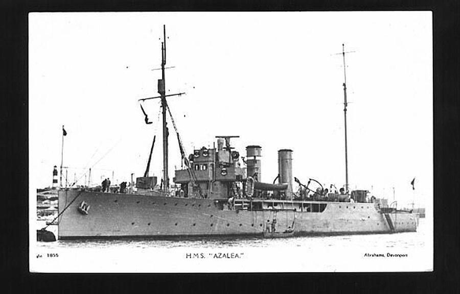
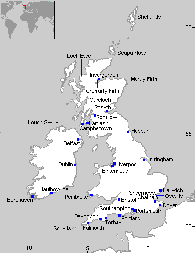
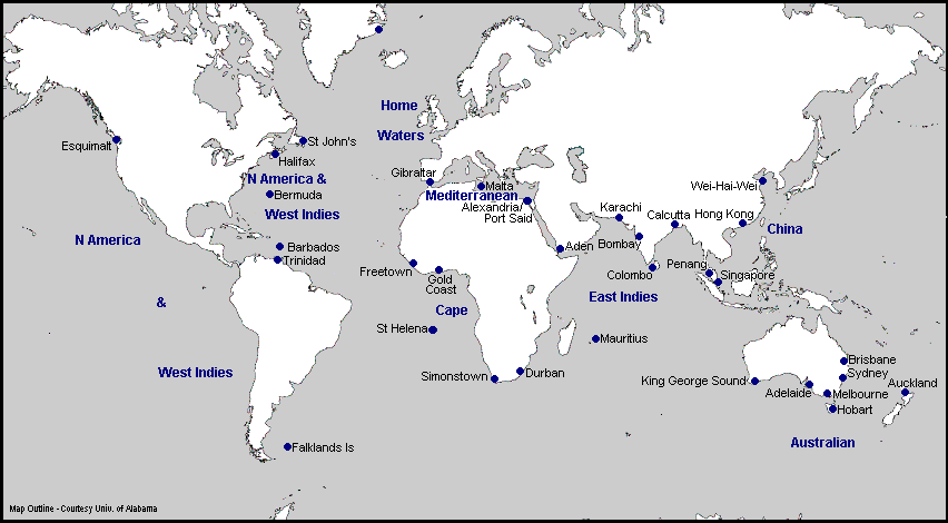
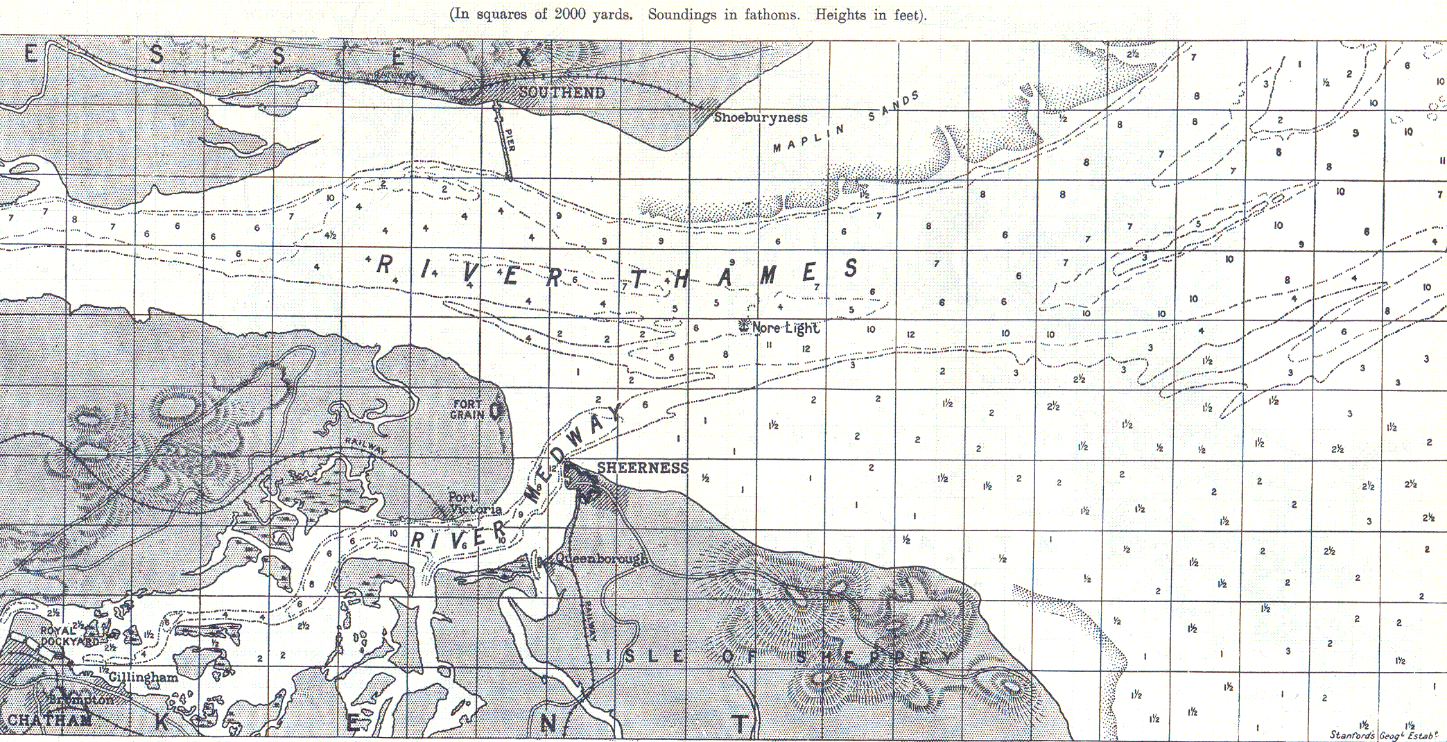
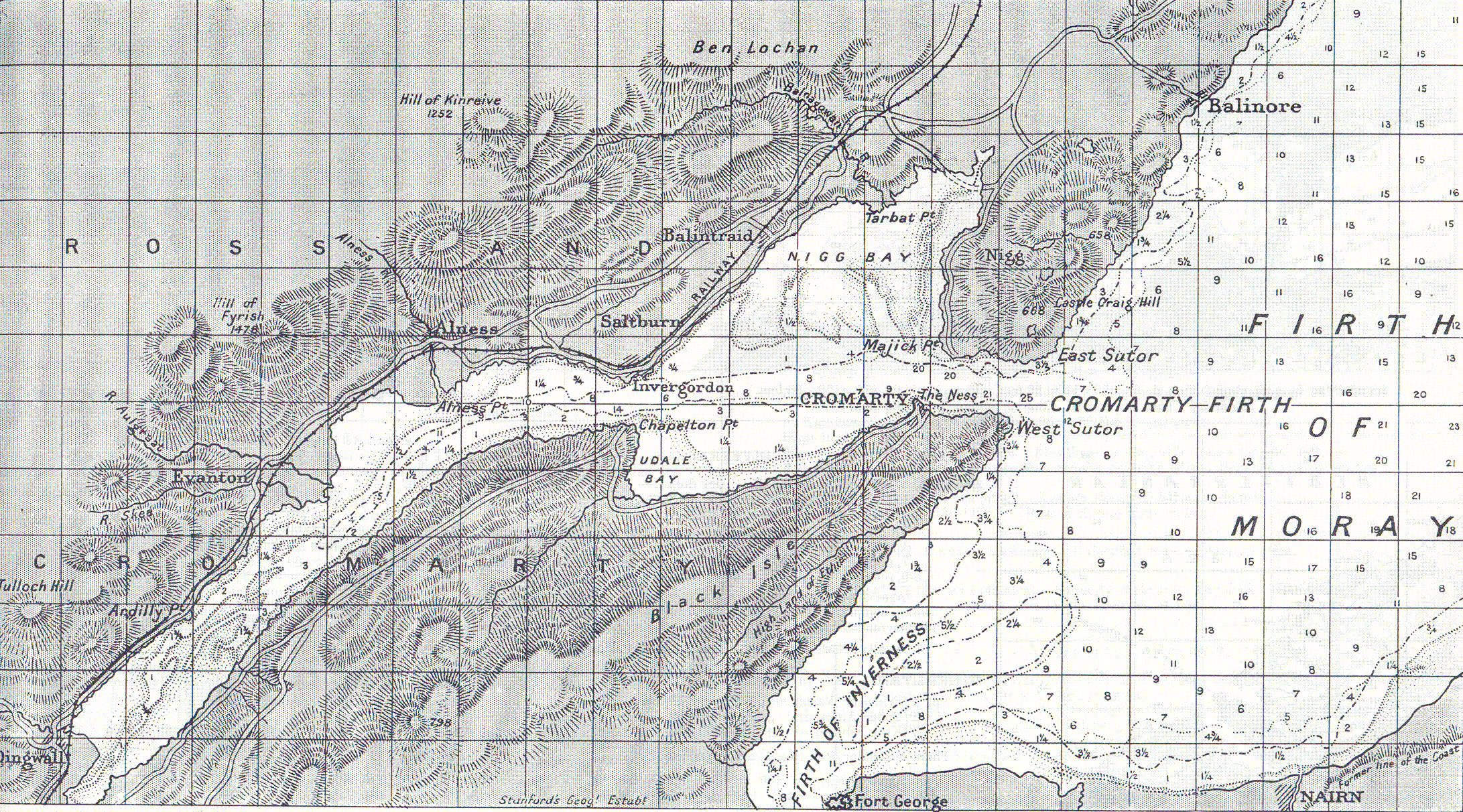
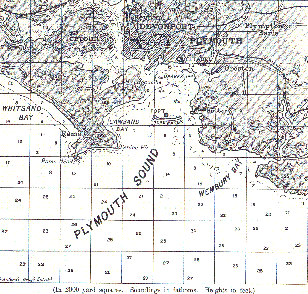
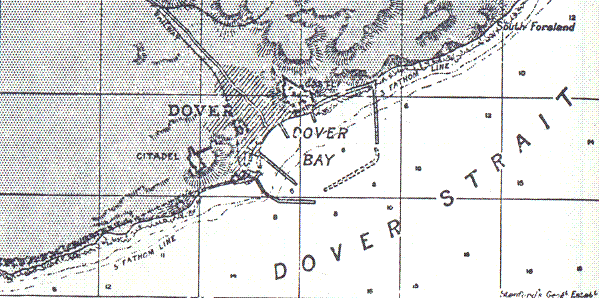
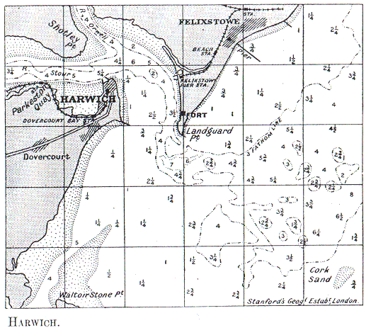
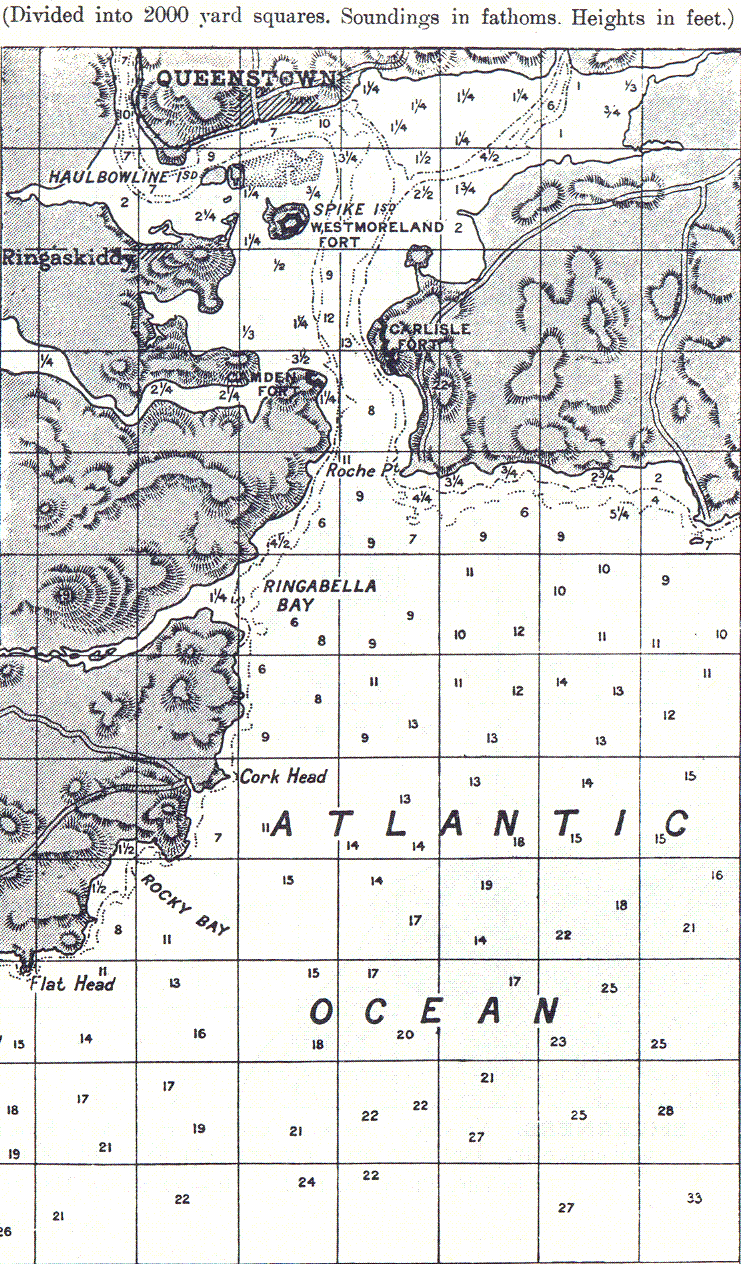
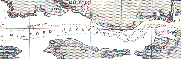
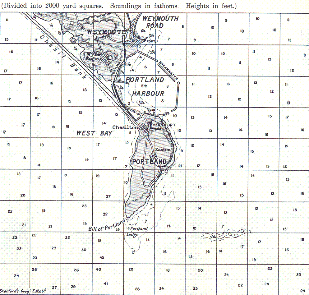
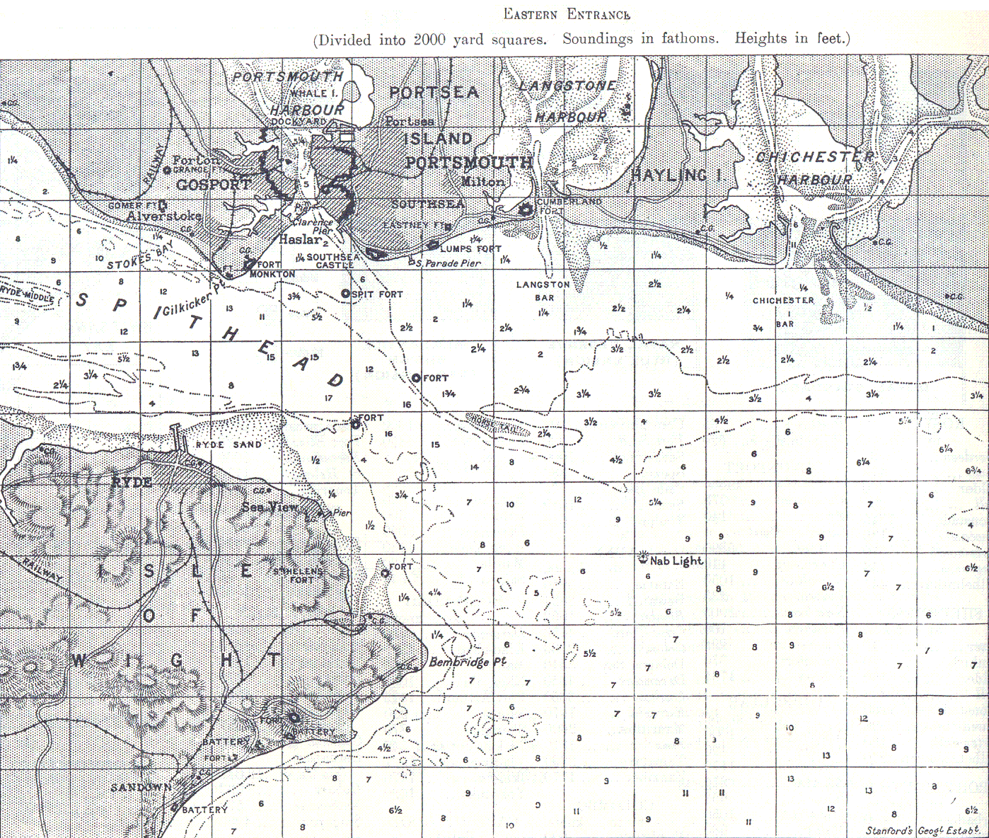
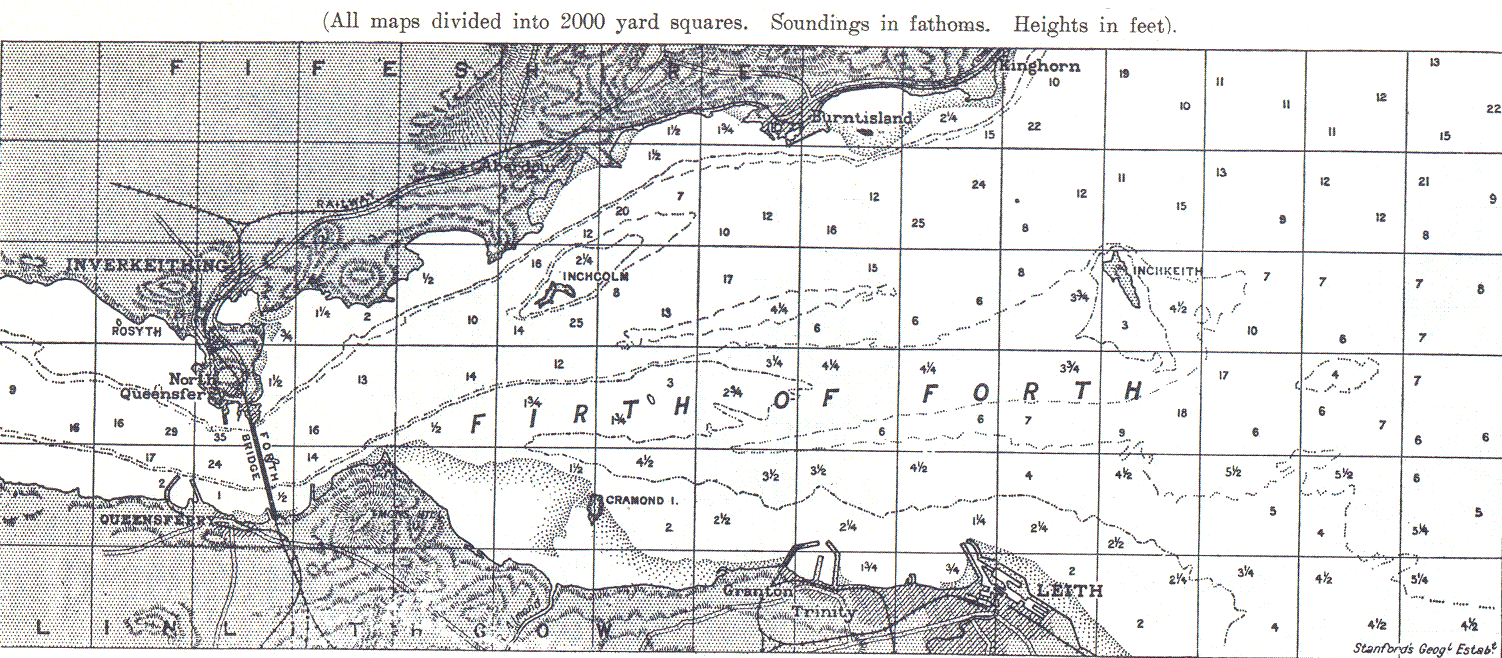
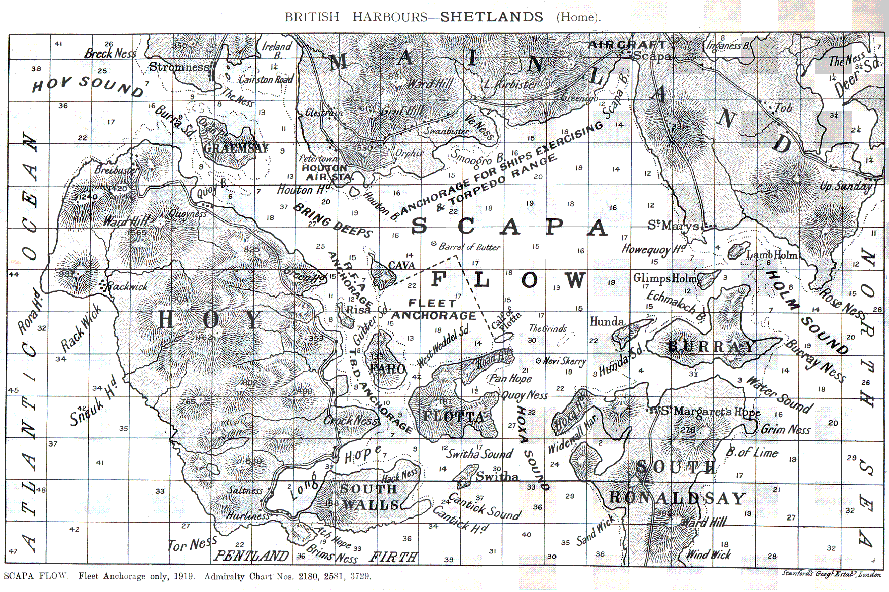
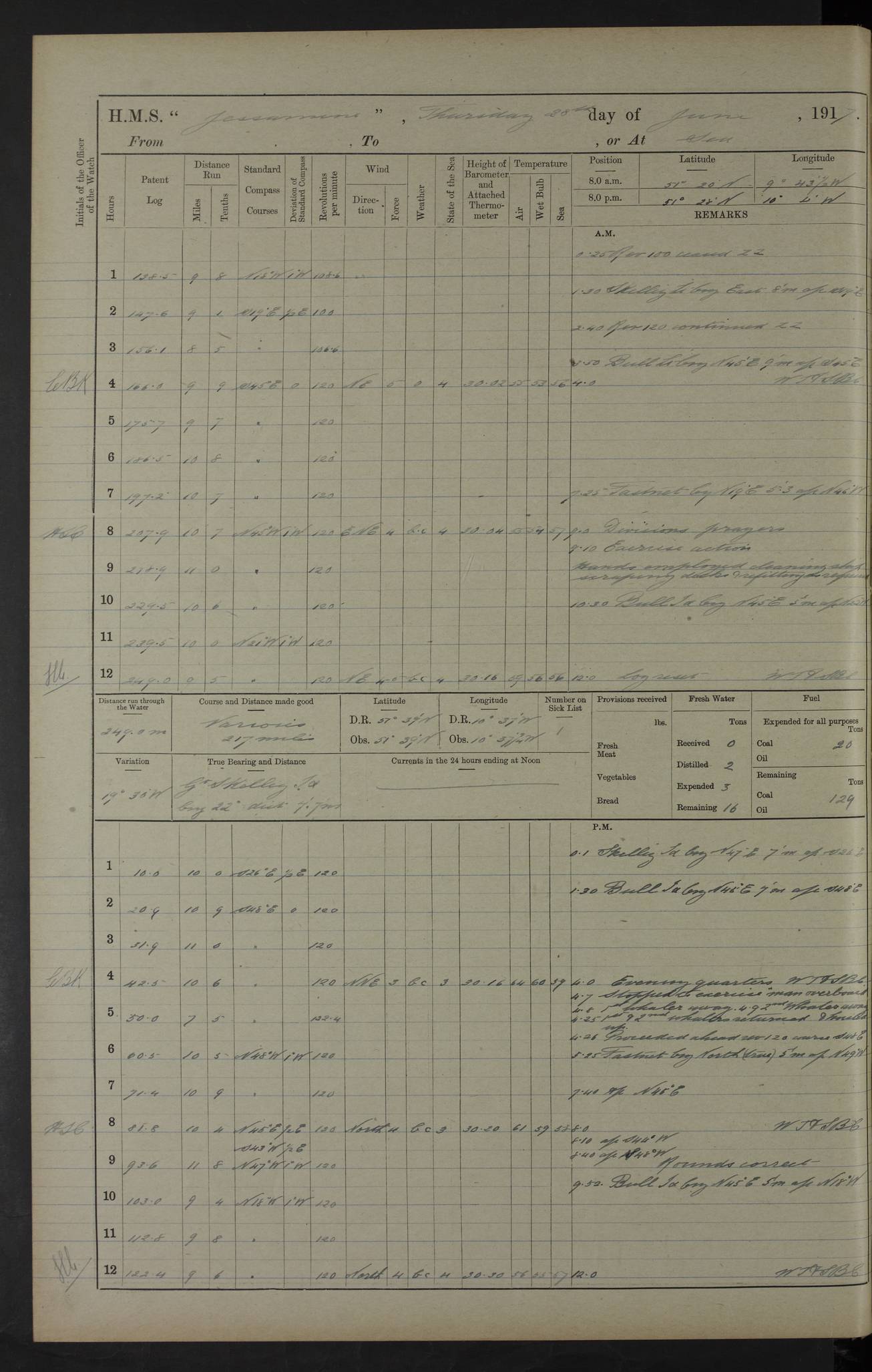
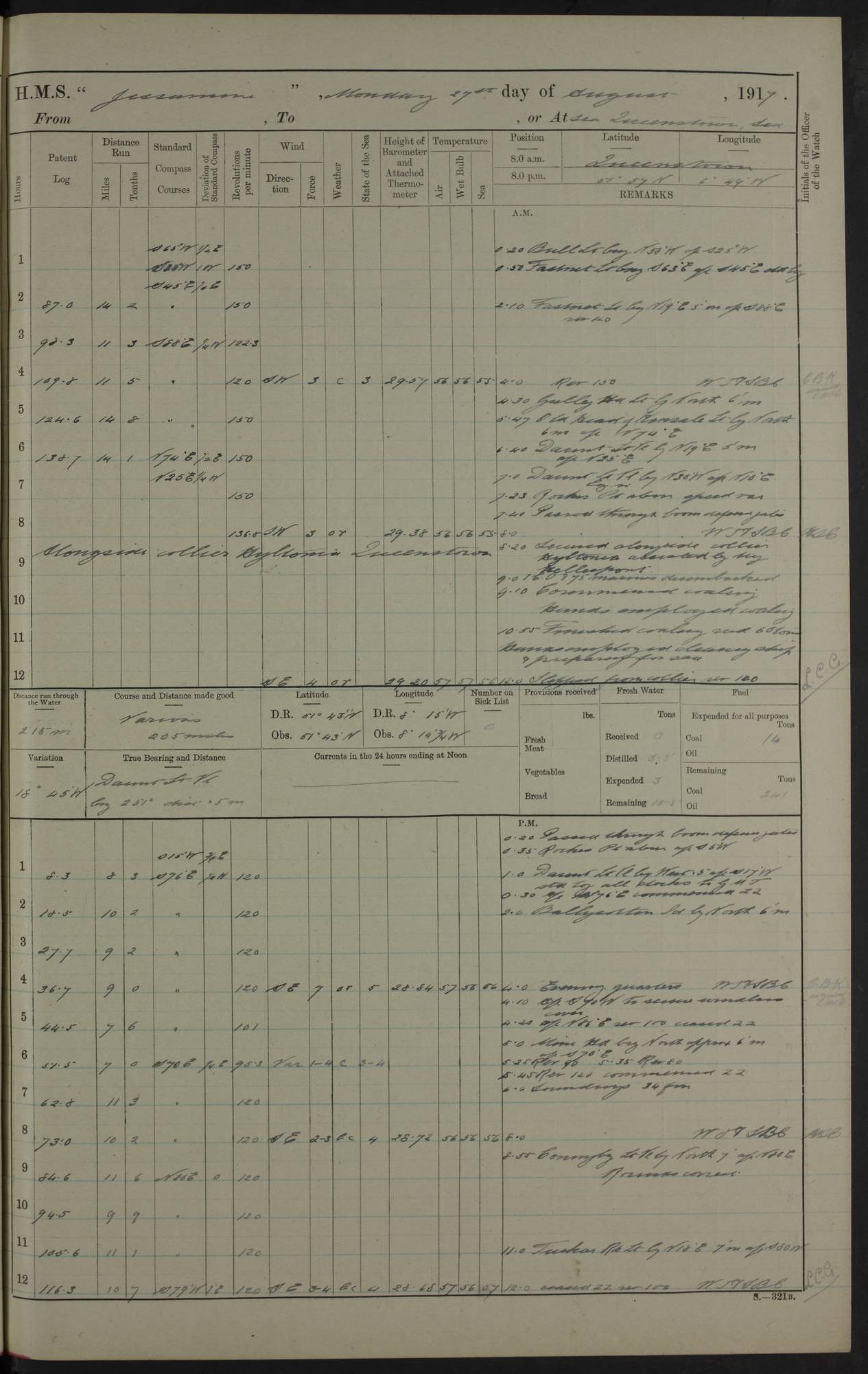
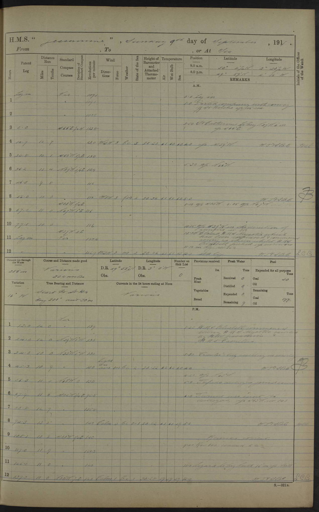
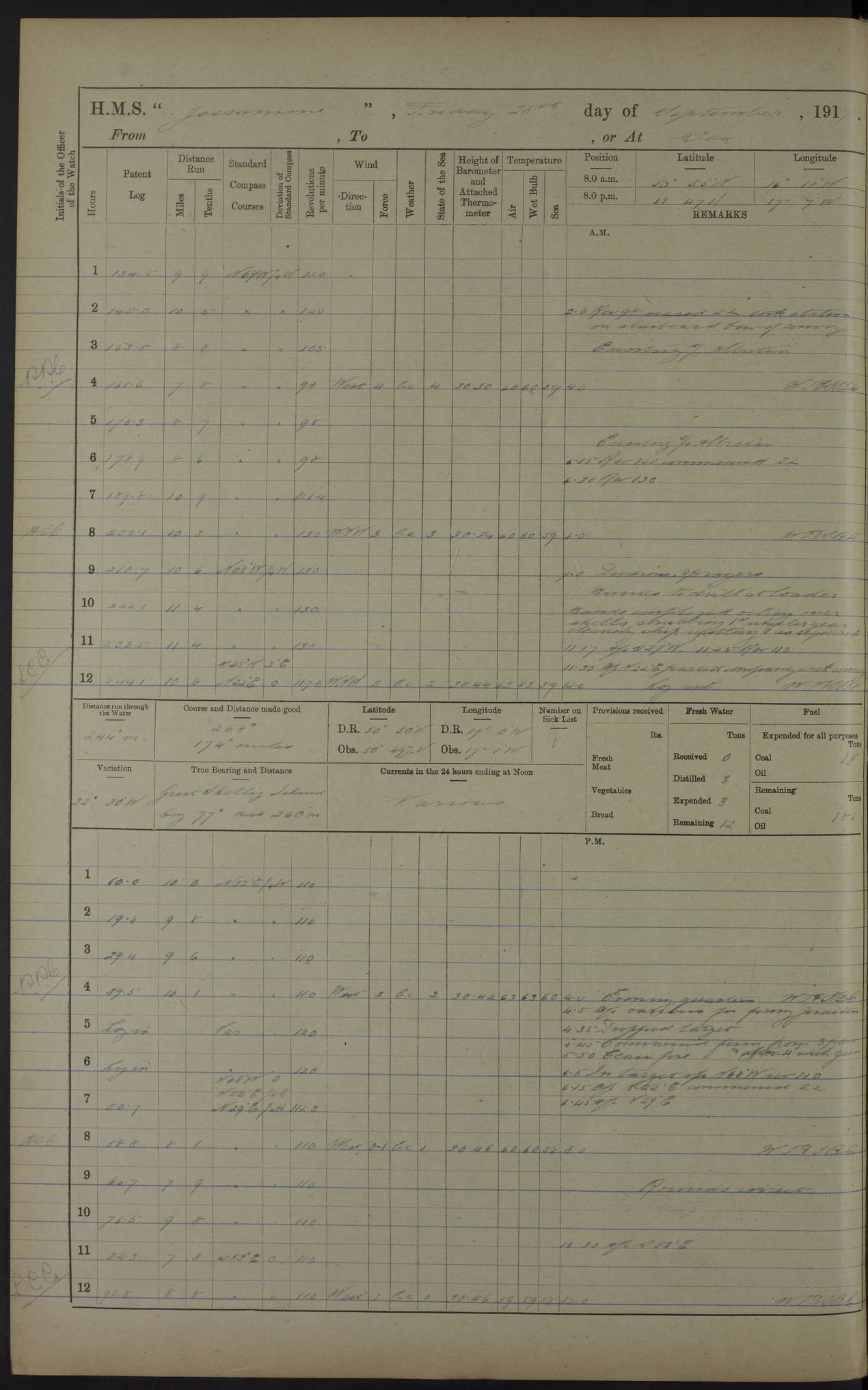
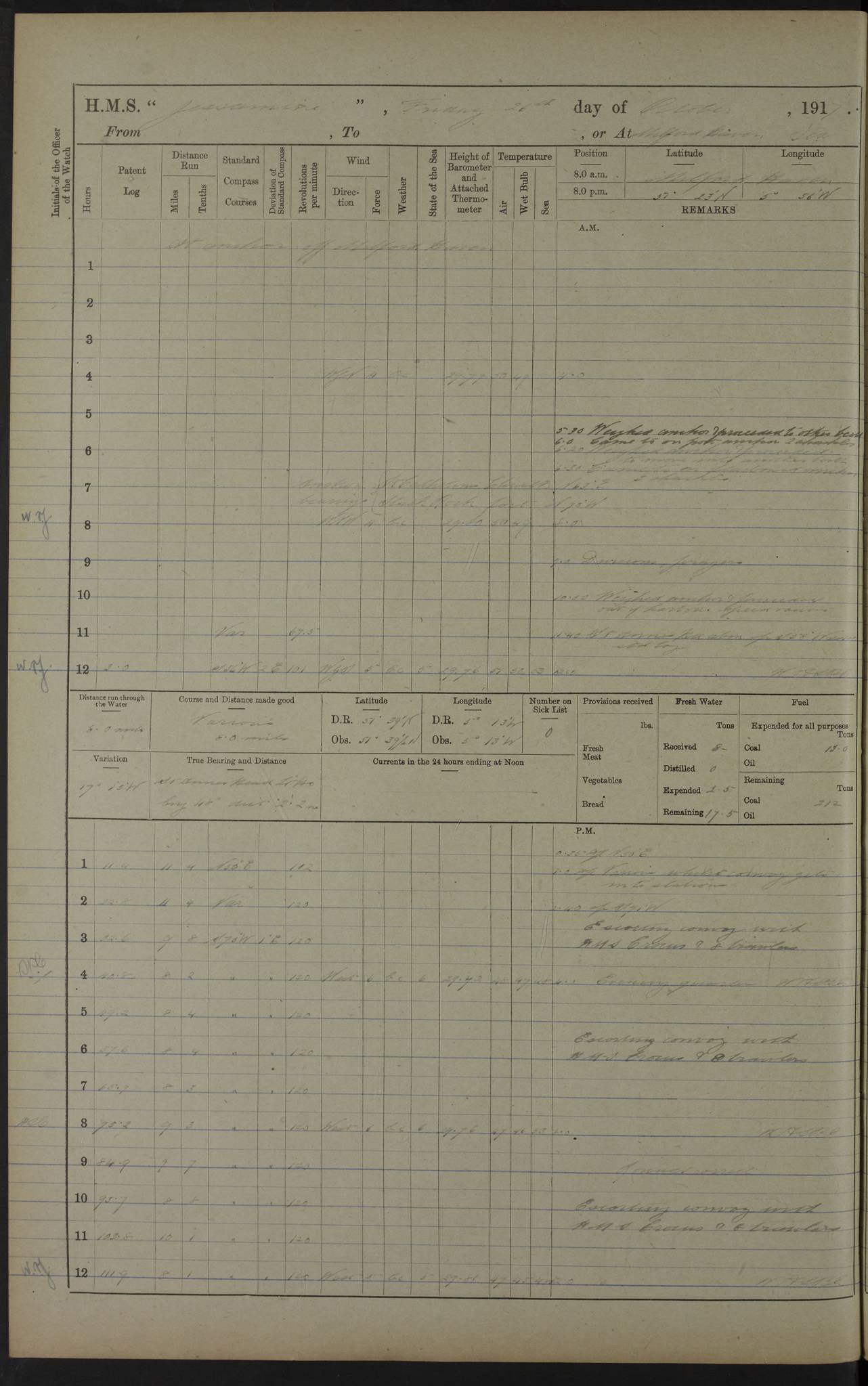
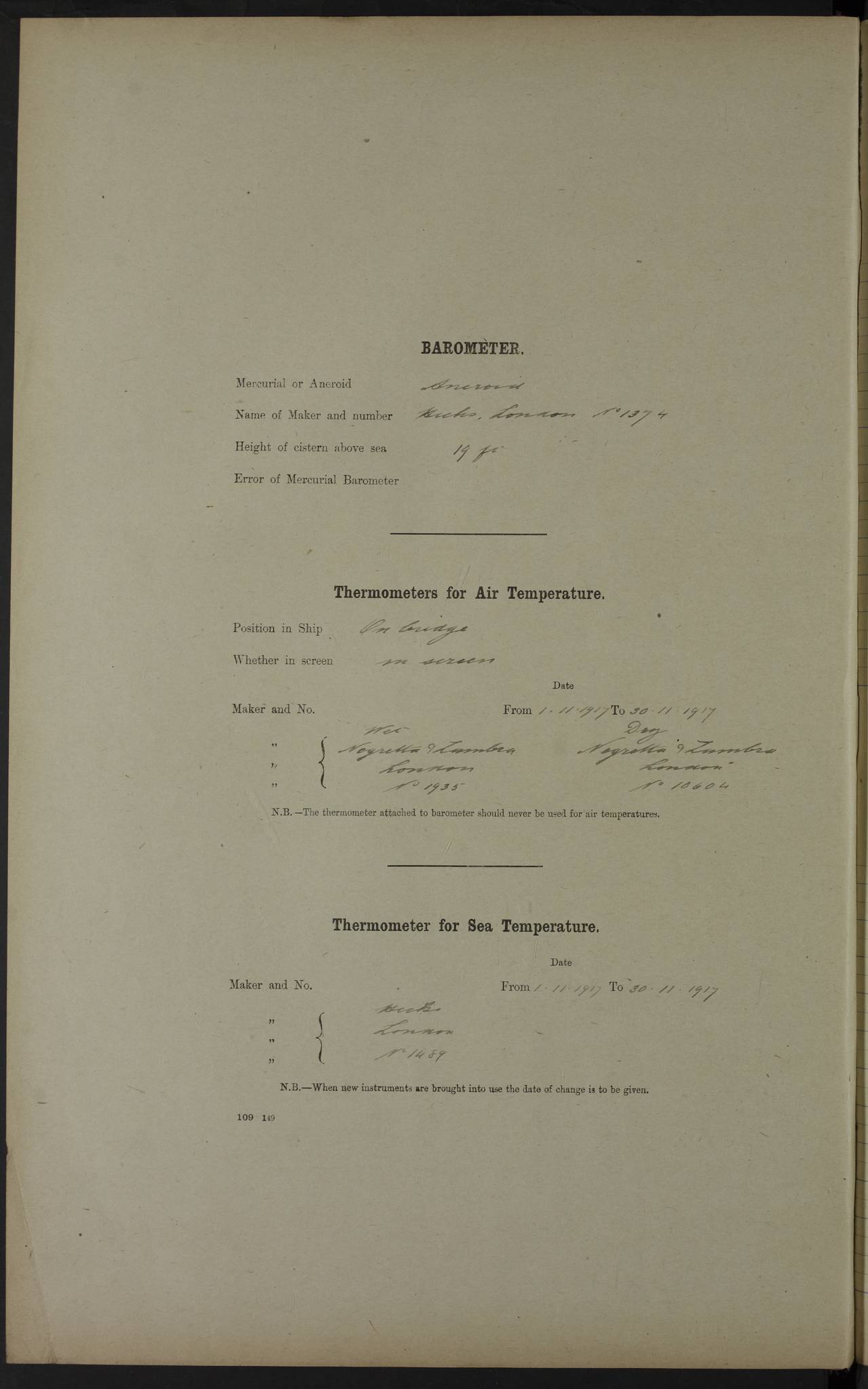
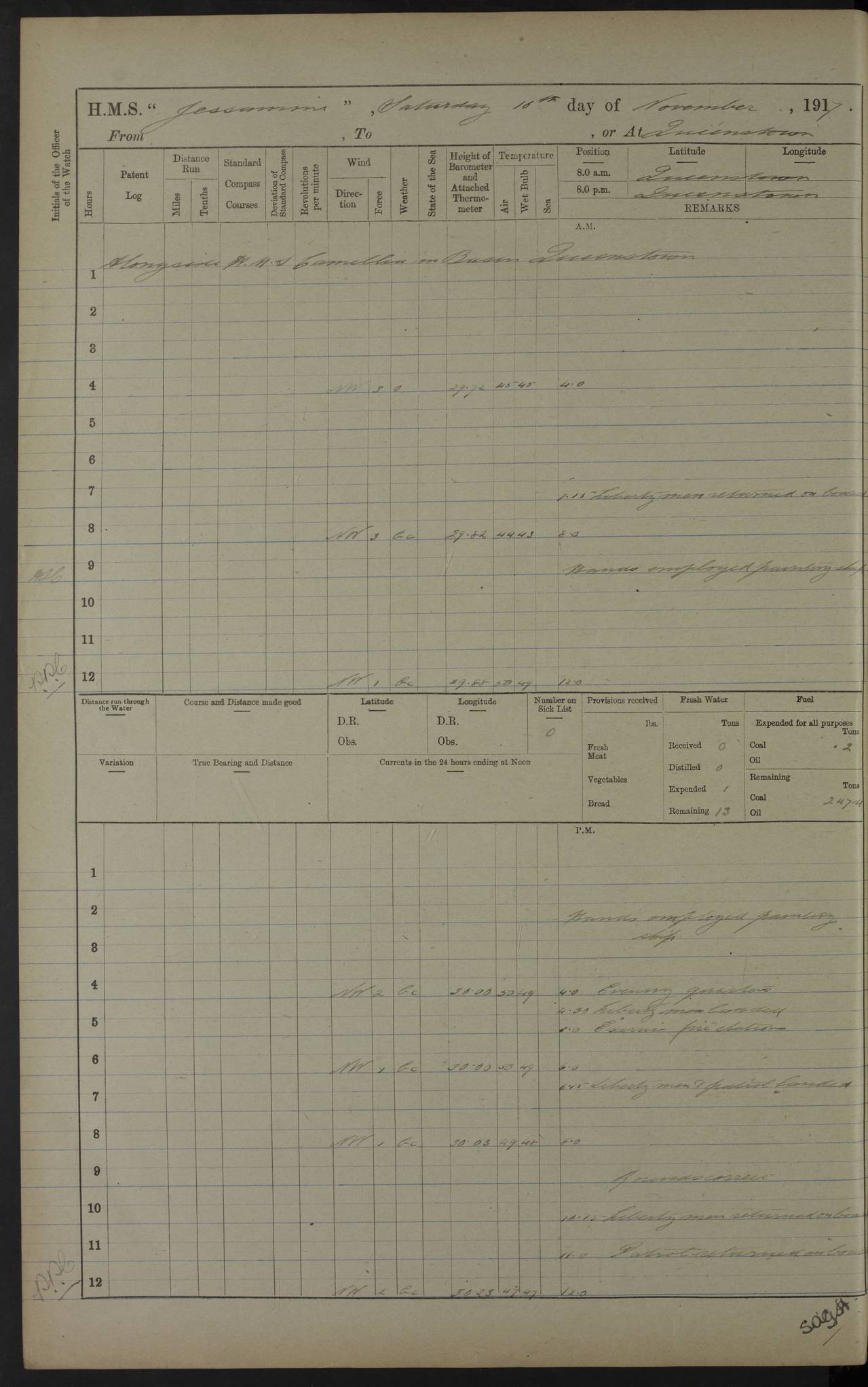
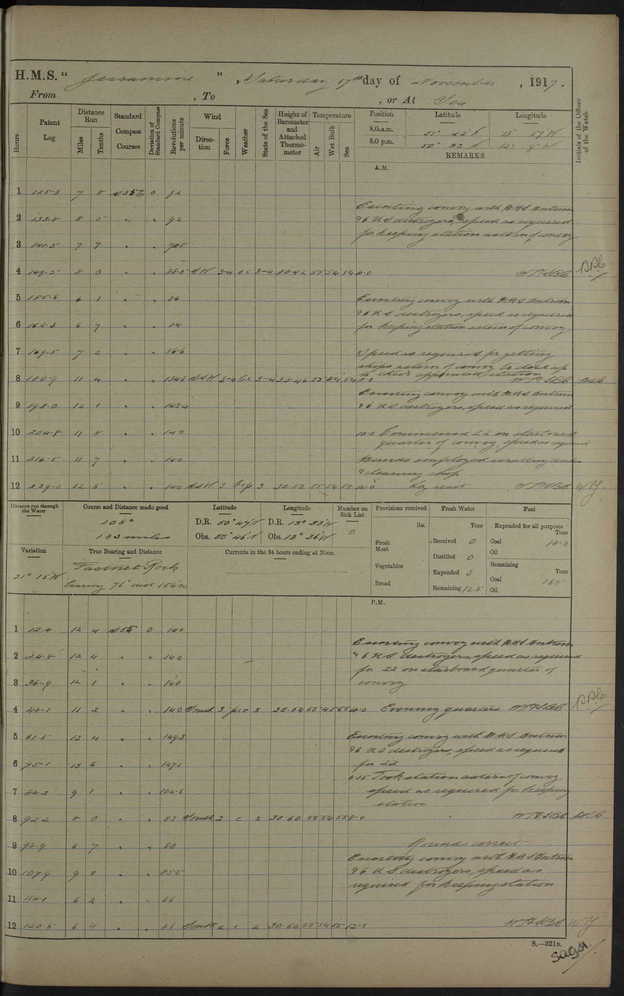
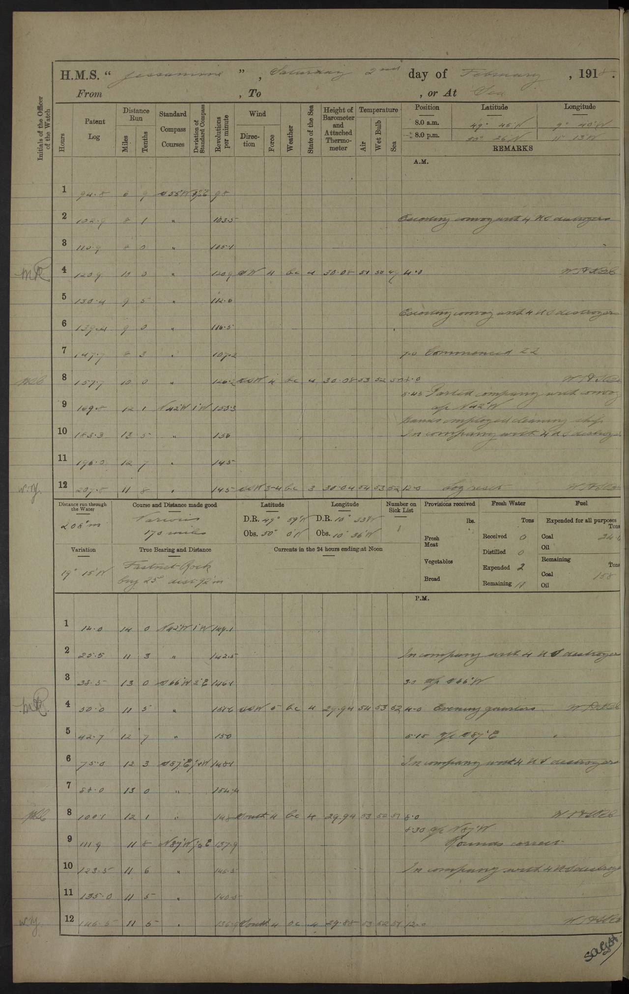
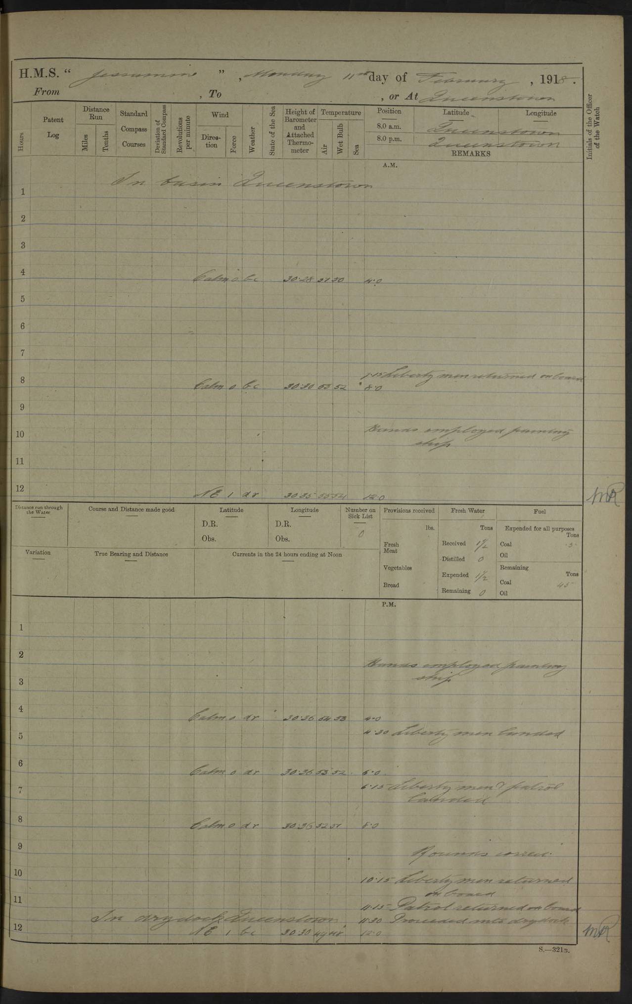
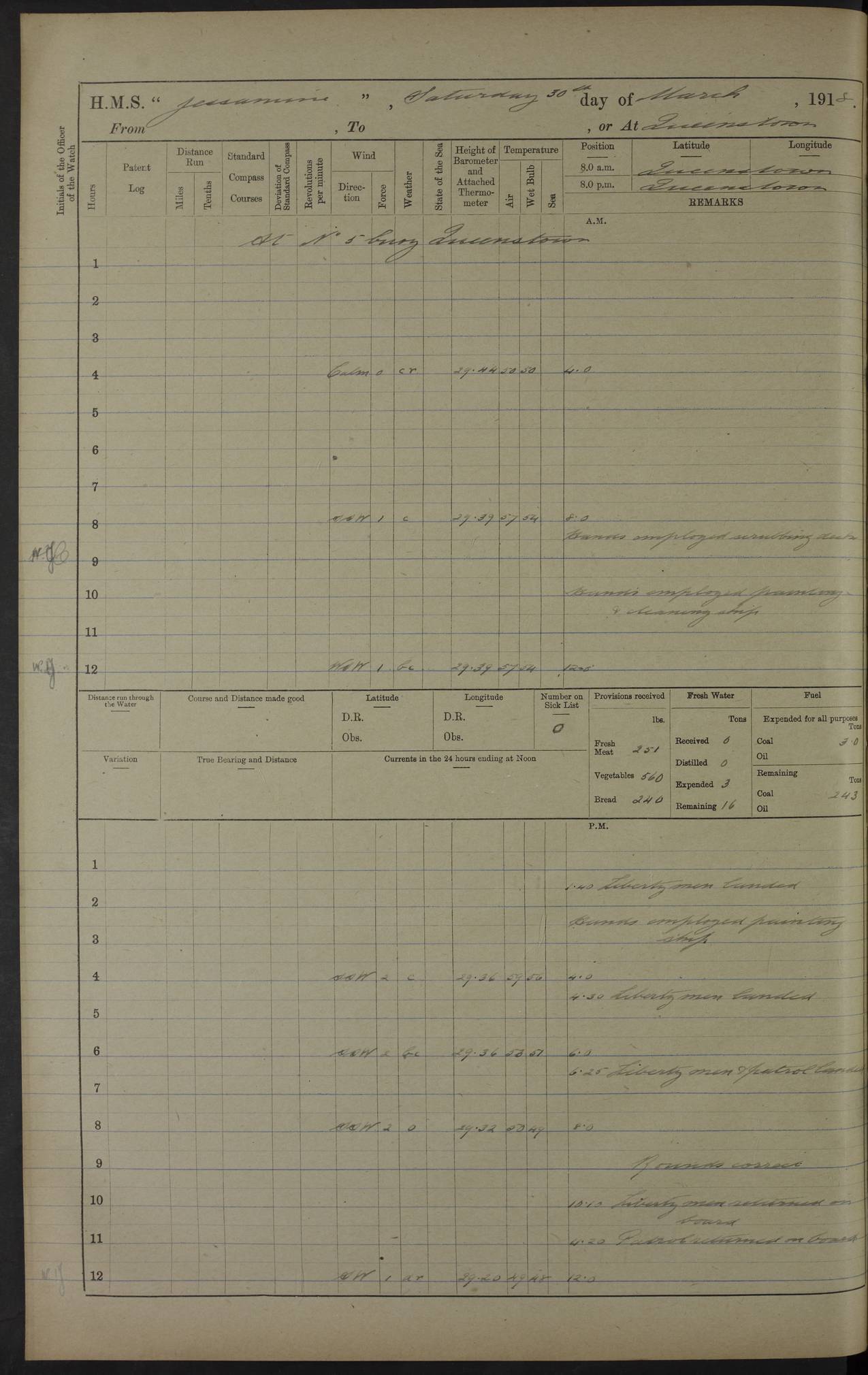
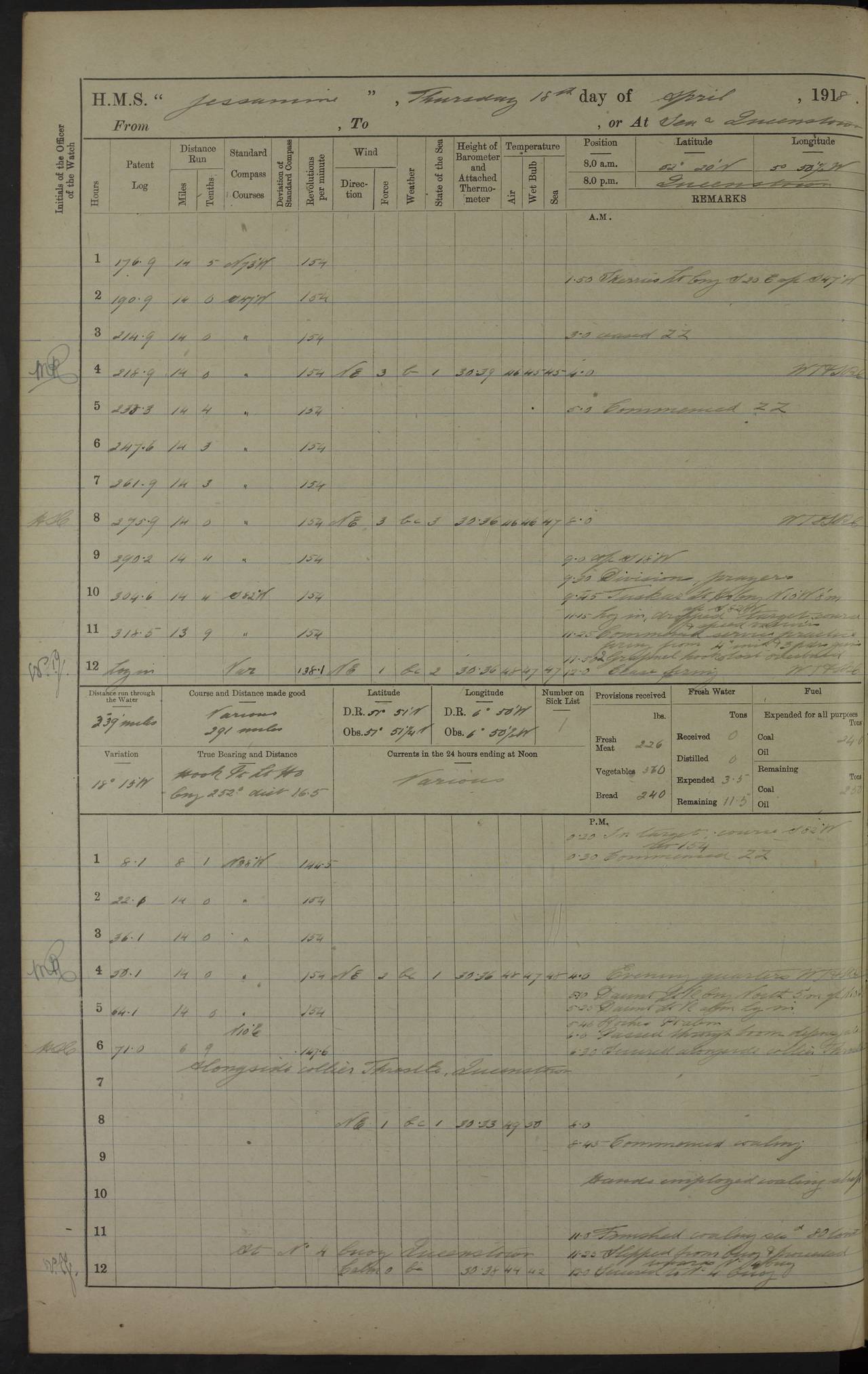
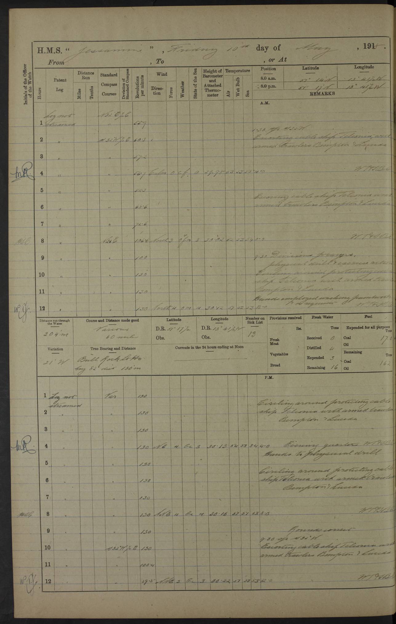
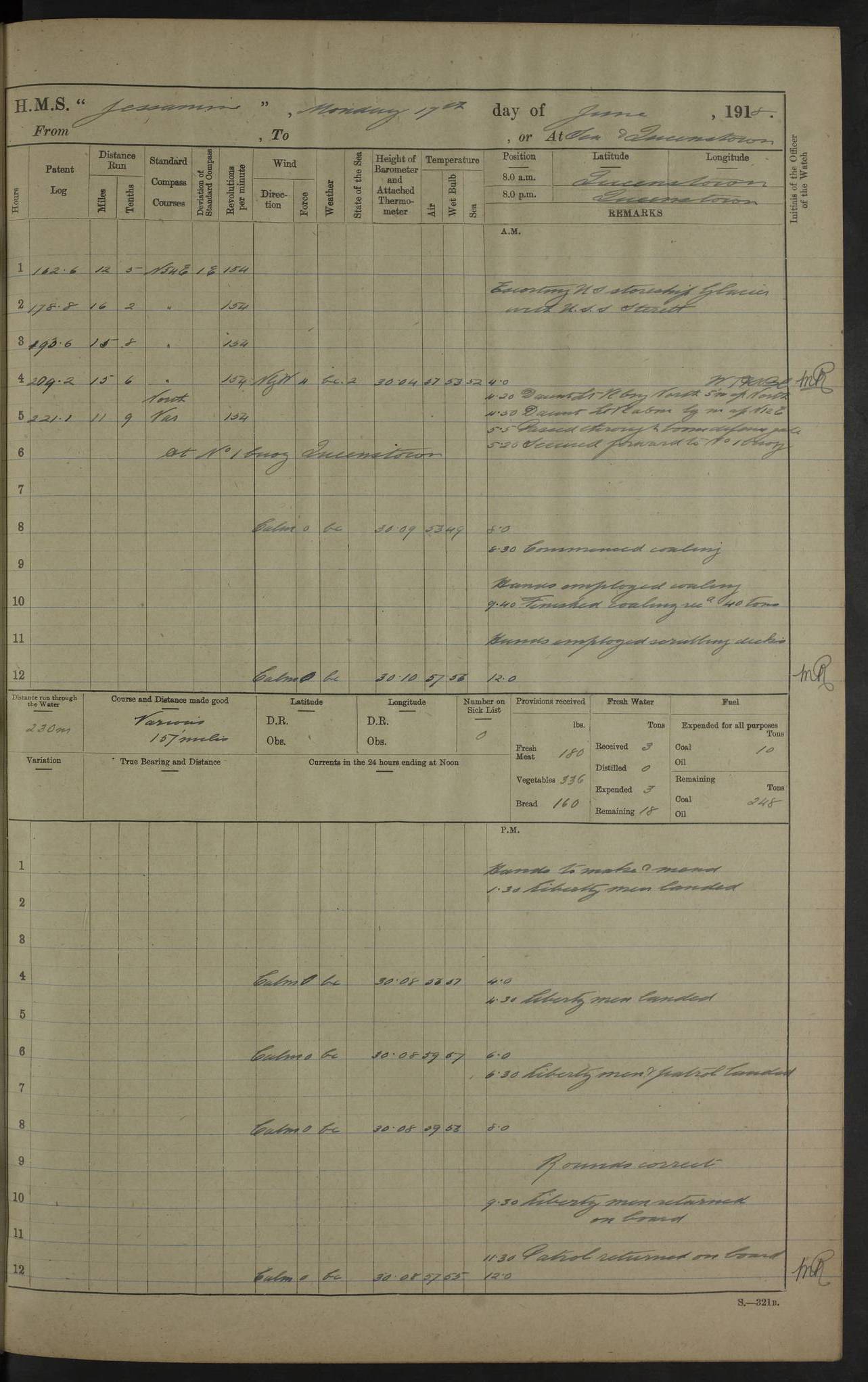
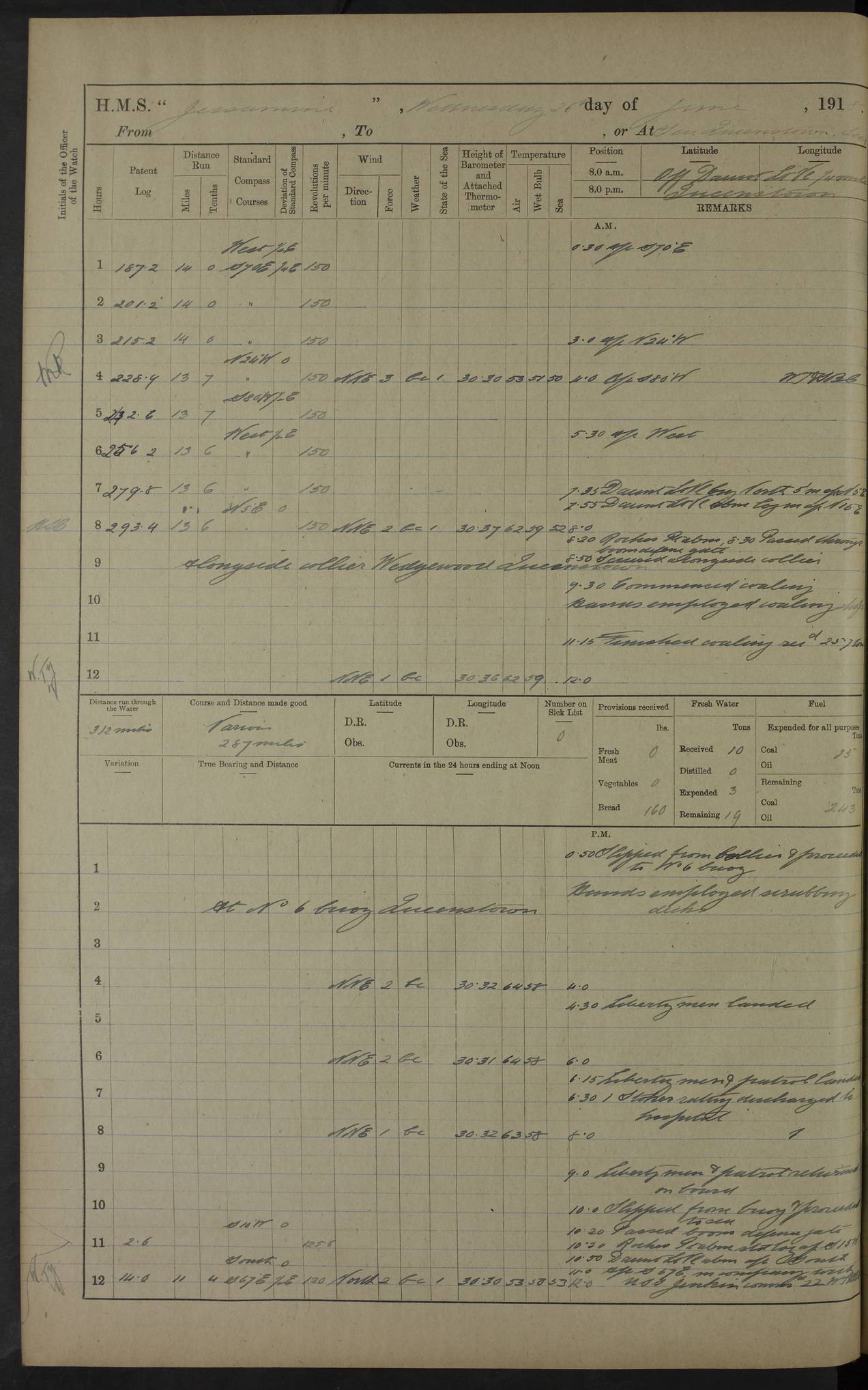
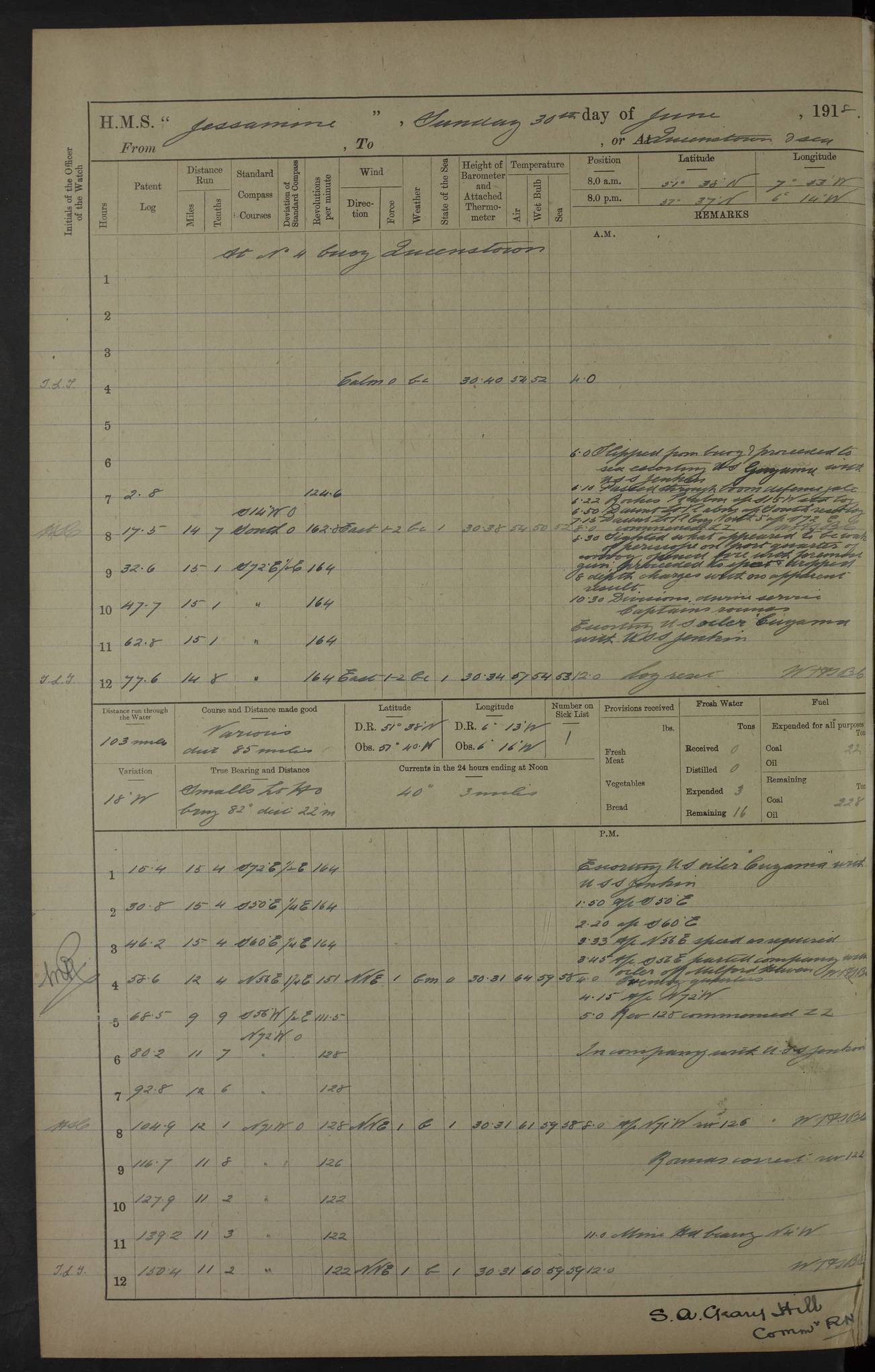
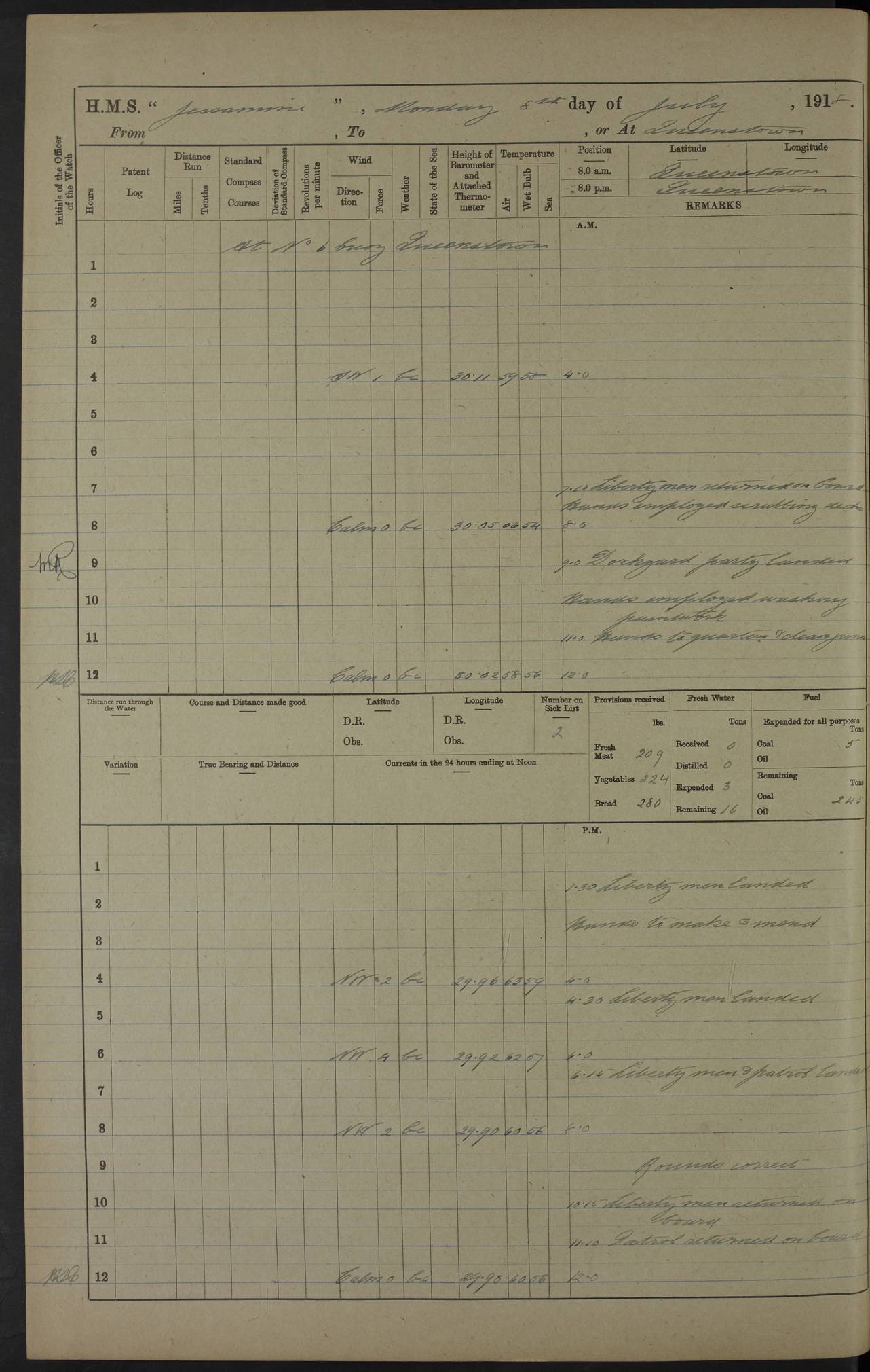
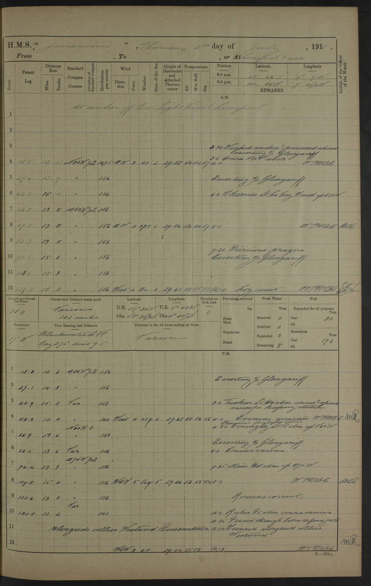
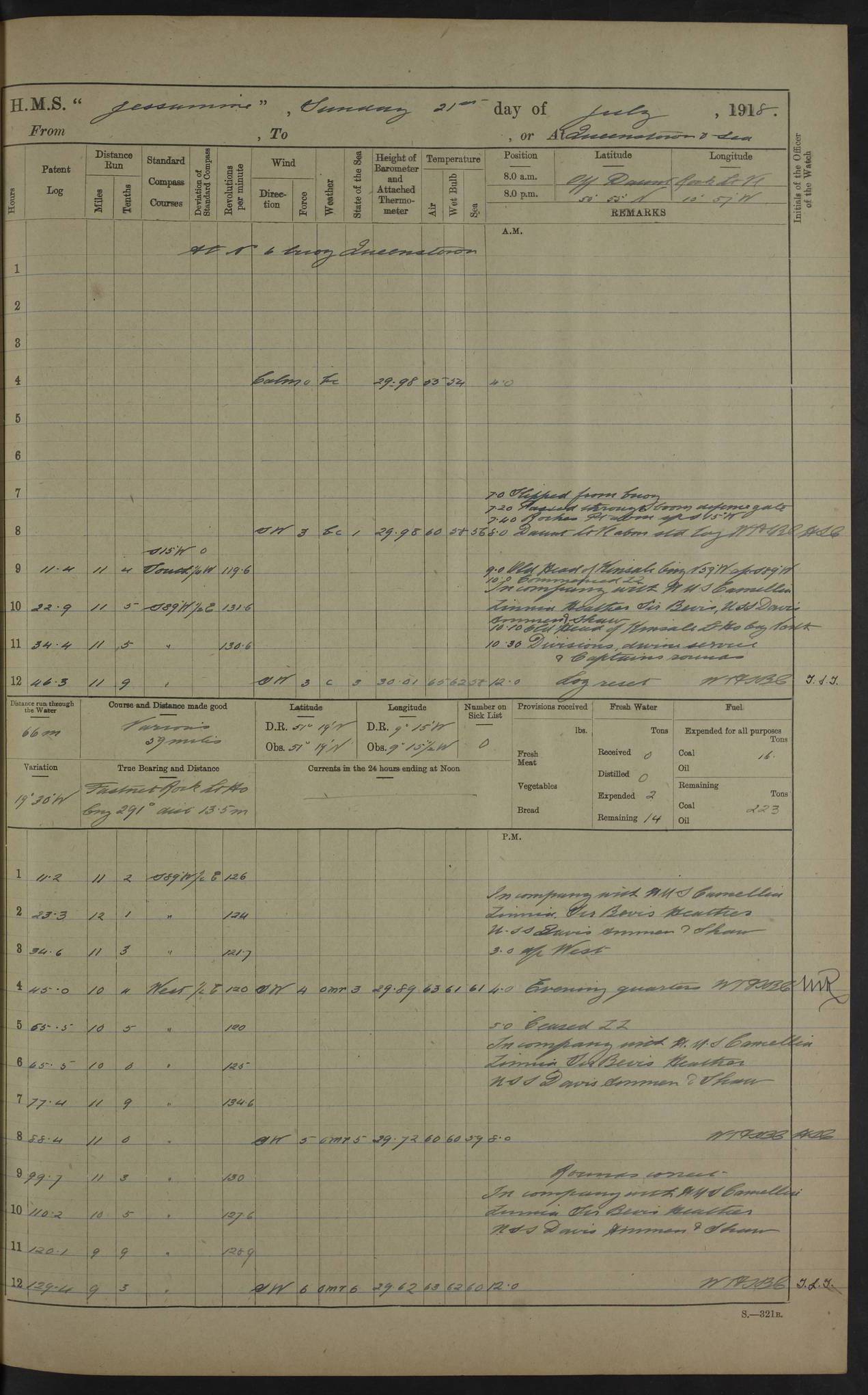
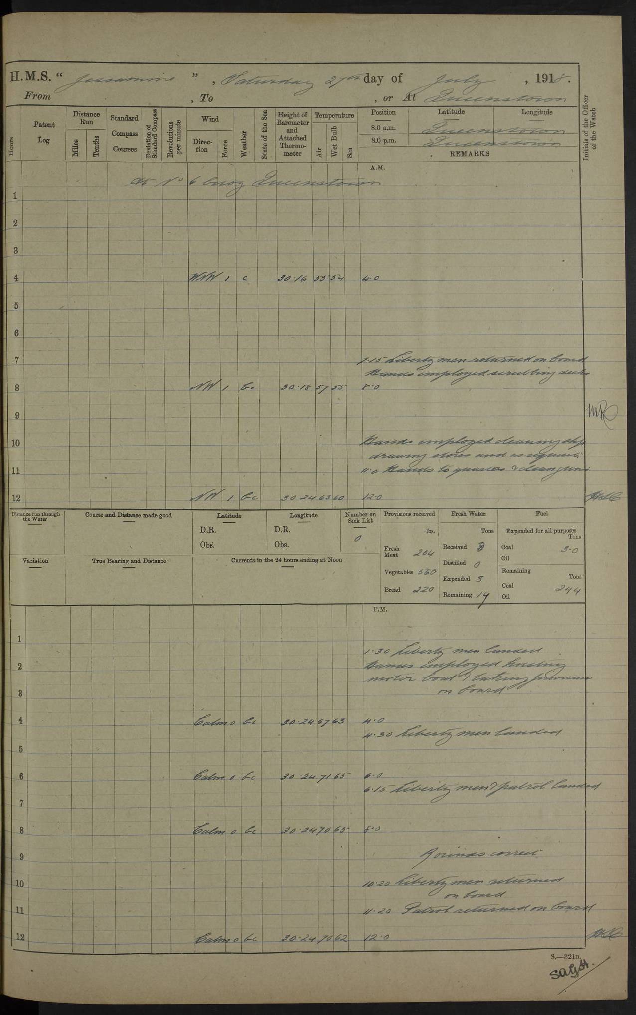
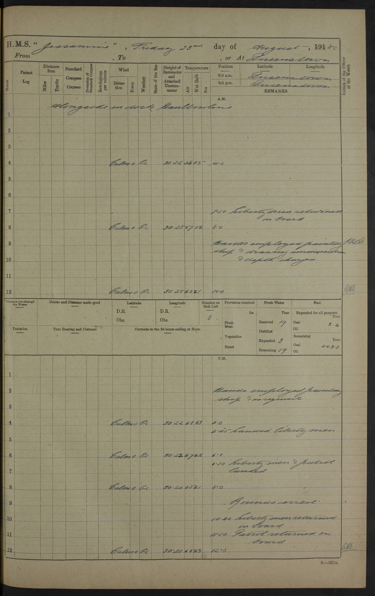
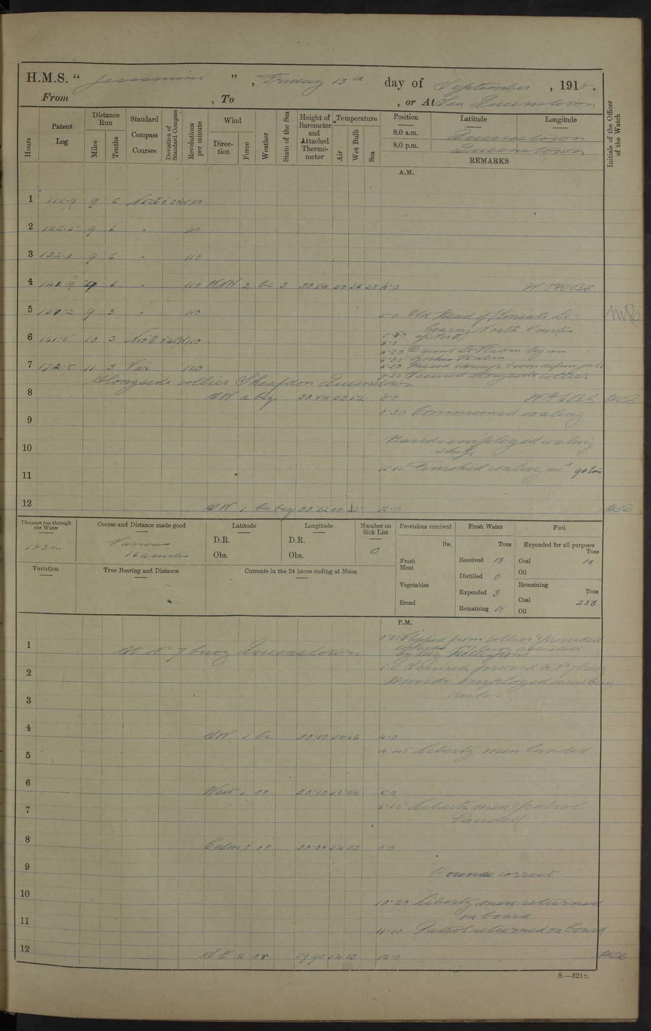